Here's something you might be interested in.
Ask a Hipster — Advice you didn't know you needed
Big Screen — Movie commentary
Blurt — Music's inside track
Booze News — San Diego spirits
Classical Music — Immortal beauty
Classifieds — Free and easy
Close to Home — What it’s like on the street where you live
Cover Stories — Front-page features
Drinks All Around — Bartenders' drink recipes
Excerpts — Literary and spiritual excerpts
Feast! — Food & drink reviews
Feature Stories — Local news & stories
Fishing Report — What’s getting hooked from ship and shore
From the Archives — Spotlight on the past
Golden Dreams — Talk of the town
The Gonzo Report — Making the musical scene, or at least reporting from it
Letters — Our inbox
Movies@Home — Local movie buffs share favorites
Movie Reviews — Our critics' picks and pans
Musician Interviews — Up close with local artists
Neighborhood News from Stringers — Hyperlocal news
News Ticker — News & politics
Obermeyer — San Diego politics illustrated
Outdoors — Weekly changes in flora and fauna
Overheard in San Diego — Eavesdropping illustrated
Poetry — The old and the new
Reader Travel — Travel section built by travelers
Reading — The hunt for intellectuals
Roam-O-Rama — SoCal's best hiking/biking trails
San Diego Beer — Inside San Diego suds
SD on the QT — Almost factual news
Sheep and Goats — Places of worship
Special Issues — The best of
Street Style — San Diego streets have style
Surf Diego — Real stories from those braving the waves
Theater — On stage in San Diego this week
Tin Fork — Silver spoon alternative
Under the Radar — Matt Potter's undercover work
Unforgettable — Long-ago San Diego
Unreal Estate — San Diego's priciest pads
Your Week — Daily event picks
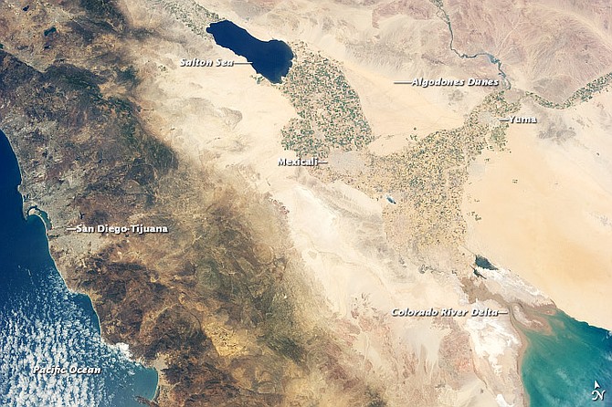
Creation of the Salton Sea
On August 9, the entire Colorado made a right turn at the Mexican cut.
In peak periods of the summer, "after melted snows of the Rockies in June reach Yuma, the Colorado would be a grand torrent"
In 1846, as General Stephen Kearny’s troops crossed the “90 miles of hell” from Yuma to Warner’s Ranch, Captain A.R. Johnson noted in a reconnaissance report, “At no distant day this place, which is now dry desert, was once a permanent lake.” As evidence Johnson pointed to white shells ringing an ancient shoreline. His was the first written word that what became known as the Salton Sink was once a vast sea. Johnson never returned. He died, a few days later, at the Battle of San Pasqual.
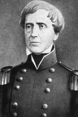
Stephen Kearny. As Kearny’s troops crossed the “90 miles of hell” from Yuma to Warner’s Ranch, Captain A.R. Johnson pointed to white shells ringing an ancient shoreline of what was known as the Salton Sink.
In 1853, William P. Blake named the region the “Colorado Desert.” He explored the dry sink, 227 feet below sea level, and named it Lake Cahuilla, after the local Indian tribe. Cahuilla oral tradition warned of sudden and dangerous floods — even of a lake growing in the desert. Blake wrote: “It is probable that the lake was long subject to great floods of the [Colorado] river at seasons of freshets” — rapid rises in the level of a stream or flood — “or by a change in its channel.”
The geography of the Colorado Desert, from the Chocolate Mountains in the east to the Lagunas and Santa Rosas in the west, resembles your bathroom sink. On the right-hand side, the raised area, the Colorado flows south to the Gulf of California. It runs on a ridge of impacted silt, like an immense aqueduct. Up until 1905, there was no Salton Sea. The depressed “sink” region — your drain in the middle — was dry, though barrancas, arroyos, and ravines forking up from the southeast and Mexico show scars of previous flooding, as does the Coachella Valley’s original name, conchella. From the Salton up to Indio, the valley brims with “little shells.”
The desert ranked among the most desolate on earth. But it was obvious: if someone redirected just a portion of the river, gravity would pull water down the gradual northwestern drop to the valley. And the rich, coffee-brown, alluvial soil would become a garden.
On April 3, 1900, George Chaffey, of the California Development Company (and founder of Ontario, California), signed a contract to irrigate the Colorado Desert. One of his first acts: he renamed the area “Imperial Valley.” He promised an Edenic empire, and by 1901 the population went from near zero to around 1500; by 1905,an estimated 12,000. They lived in shacks, brush ramadas, and adobe houses and dreamed of green vistas.
Mark Twain chortled that when he fell into a California river, he “came out all dusty.” As they saw it, the problem for the CDC wasn’t where to make a cut in the river, but how to regulate the flow. For parts of the year the Colorado is almost dry. The CDC promised customers a regular daily amount. Because of this, they fretted more about too little water than too much.
But in peak periods of the summer, writes Helen Hosmer,“after melted snows of the Rockies in June reach Yuma, the river would be a grand torrent, carrying 50, 100, even 150,000 cubic feet of water past a given point each second,” and “each cubic foot might contain as much as a quarter-pound of silt.”
Also in midsummer, Arizona and New Mexico’s rainy season, the swelling Gila River joins the Colorado east of Yuma and creates liquid havoc. In Harold Bell Wright’s novel, The Winning of Barbara Worth (1911), the savvy Abe Lee warns, “The Rio Colorado alone won’t hurt us, but when the Gila and the Little Colorado go on the warpath and come down on top of a high Colorado flood, you’ll catch hell.”
Chaffey constructed a diversion headgate at Pilot Knob, west of Yuma across the river, one mile north of the Mexican border. He couldn’t route the in-flow due west, however. The Algodones sand dunes — the enormous “walking hills”— prevented direct access. So Chaffey swung south into Mexico, then connected with the prehistoric Alamo barranca. Using everything from Fresno scraper plows to shovels and hoes, laborers dug, cleared brush, and shaped 50 miles of canals, feeder channels, and ditches south, then west-northwest, to the valley. On the morning of May 14, 1901, Chaffey raised the wooden headgate. By June the inflow reached the new border towns of Calexico and Mexicali. Almost overnight El Centro, Brawley, and Holtville, which started as supply camps, sprouted into tent communities.
Kevin Starr: “By scraping a downhill ditch for little more than 50 miles, Chaffey and his associates had acquired control of the productivity, hence the ultimate value if not the formal ownership of a million public acres.”
By 1903, the Pilot Knob intake’s first four miles, which weren’t graded properly, silted up. The CDC had promised a steady flow of water, at $5.75 an acre, not the trickle meandering toward the valley when the Colorado was low. Irate settlers, farming in an outdoor oven where “man was hardly welcome,” threatened lawsuits. The summer of 1904 was another moderate flood season. And the CDC, now led by A.H. Heber and C.R. Rockwood, opted — many say out of panic — for a radical measure: bypass Chaffey’s gate.
Four miles below the Mexican border, across from an island of cottonwoods, Rockwood made an “open river cut” — a 50-foot-wide, 6-foot-deep gap — on the Colorado’s west bank. By October 1904, without permission from Mexico, the CDC completed a 3300-foot feeder channel from the cut west to the Alamo canal. Rockwood didn’t build a headgate; he saw no need to halt the river’s flow. In fact, he constructed temporary wing dams in the river to guide the current toward the “Mexican cut.”
The result was a two year disaster, known as the Great Flood of Imperial Valley. Rockwood later wrote, “I doubt whether any one should be accused of negligence or carelessness in failing to foresee that which had never happened before.” He had studied the river’s recorded history: 27 years of daily “rod readings” at Yuma marked only three winter floods and never two in one year. “It was not probable, in the winter of 1905, that there would be any flood to enlarge the cut made by us, and without doubt…we would be able to close the cut before the approach of the summer floods.”
In the spring of 1905, between February and early April, the Colorado flooded five times.
Rockwood writes that in the middle of January, while hunting south of the Mexican cut, he hitched his boat to the embankment of an almost dry channel. When he returned, the boat was far downstream. He first assumed it just came loose. Then he realized: the river is flooding.It took him three days on foot, through willows, tough mesquite, and spearstiff arrowweed, to reach the cut.
Chroniclers of the Great Flood don’t count this brief onslaught, which reached 23.8 in gauge height, as one of the five. Two heavier deluges hit in February. They gushed through the cut, down the canals, and into the basin. They also left large silt deposits at the opening. Rockwood claims he wasn’t alarmed until a third flood, on March 3,“was sufficient notice that we were up against a very unusual season, something unknown in the history of the river as far back as we were able to reach.”
The third, a monster had twice the volume of the others. Rockwood ordered the cut closed with pilings, sandbags, and arrowweed riprap. William deBuys: “In this effort, as in all that followed, CDC’s engineers and laborers were working blind. They had no scouts upstream of Yuma to warn them of surges coming down the Colorado or the Gila, and hence they had no way to time their most delicate operations under favorable conditions.” They also had no idea that 1905–’06 would be a record season. “Scientists using tree-ring data to reconstruct watershed yield for the upper Gila and other rivers have concluded that 1905 may have been the wettest year for that part of the Southwest in several centuries.” The Colorado resembles a giant, sinuous buzzsaw. Only the Tigris carries more silt.
The Colorado raises its own bed a foot a year and deposits a million tons a day in Lakes Mead and Powell. The river carries enough silt, in one year, to refill the Panama Canal.
When it floods, the Colorado clogs with “drift”: brush, leafmold, treetrunks, railroad ties, disintegrated rock, boulders. These chew like teeth. Cory: “When the river falls rapidly, much of this drift becomes stranded in the bed and is left ready for the next flood.” Throw the river’s rampant scouring action against crumbly alluvial soil — which melts, writes Ednah Aiken, “like sugar”— and the Colorado can gouge out whole canyons, including the Grand.
Before workers could close the Mexican cut, on March 25 a fourth flood demolished the makeshift dam in a few hours. A fifth, in early April, obliterated another attempt. As the pilings ripped away, the cut began to widen.
The fifth flood delighted the farmers. The valley had plenty of water. Their alfalfa, Egyptian corn, and grains flourished. The only complaints came from the New Liverpool Salt Works. It stood deep in the Salton Sink, which was fast becoming an inland sea.
Toward the end of April, the river dropped to 24 feet. Captain J.A. Mellen of the steamer Cochan argued that the CDC should tow an old barge down from Yuma, fill it with boulders, and scuttle it at the Mexican cut. The river was low enough. Godfrey Sykes: “There is little doubt that this plan would have succeeded, and that the whole course of the river and valley history would have been changed.”
No one accepted the idea — too expensive — and the Colorado rose again in May. During the summer of 1905, the river averaged a height of 29 feet and 90,000 “second feet.” A cubic foot of water equals 7.48 gallons. A “second foot” is a unit of flow: it equals one cubic foot of water per second. During summer, between 14,000 and 25,000 second feet sped through the Mexican cut. With less water running through it, the old channel began to silt up. Willows sprouted where the river once roared.
The banks of the cut began to cave in. The aperture, widened from 60 to 160 feet, became a spillway. On August 9,the entire Colorado made a right turn at the Mexican cut, powered through the breach, gushed down the Alamo canal into the valley, and created the Salton Sea.
In haste, Rockwood tried to construct a jetty between the half-mile-long island in the river — soon to be called “Disaster Island” — and the Mexican cut. In theory, log pilings, sand, and brush mattresses would divert the river back to its original course. On November 29, however, the Gila rose ten feet in ten hours, then rose again. Brownish-red with drift and flotsam, the wall of water bullied down the Colorado with 100,000 second feet. It wiped out the jetty and stranded 240 workers on Disaster Island.
All night the torrent hammered the island. Its western banks, side-cut by the river, began to wash downstream. In the morning a barge — the one Captain Mellen wanted to scuttle? — braved the flashflood current and rescued the workers.
Cory: “It was soon obvious that it would be folly to resume work at that location, and that the piling-brush-sandbag-barrier-dam method was not to be given further consideration.” Another observer was less delicate: “They might as well attempt to plug an open faucet with a postage stamp as to stop this flow with brushwood mats.”
In the next few months, almost 50 engineers visited the site. No two, writes Cory, “agreed on any one plan as offering the greatest chances of success.” What was clear: the Colorado River had made a giant geological shift and that to prevent it from inundating the entire Imperial Valley, workers must battle an imperious invader. And the war had just begun.
SOURCES:
- Aiken, Ednah,The River (Grosset & Dunlap, 1914)
- Cory, H.T.,The Imperial Valley and the Salton Sink (John J. Newbegin, 1915)
- deBuys, William, Salt Dreams: Land & Water in Low-Down California (New Mexico Press, 1999)
- Hosmer, Helen, “Triumph and Failure in the Imperial Valley,”The Grand Colorado: The Story of the River and Its Canyons (American West Publishing, 1969)
- Rockwood, Charles Robinson, Born of the Desert (Calexico, 1909)
- Starr, Kevin, Material Dreams: Southern California through the 1920s (Oxford, 1990)
- Sykes, Godfrey, The Colorado Delta (Kennikat Press, 1937)
- Wright, Harold Bell, The Winning of Barbara Worth (A.L.Burt Company,1911)
Here's something you might be interested in.
Creation of the Salton Sea
On August 9, the entire Colorado made a right turn at the Mexican cut.
Creation of the Salton Sea
On August 9, the entire Colorado made a right turn at the Mexican cut.
In peak periods of the summer, "after melted snows of the Rockies in June reach Yuma, the Colorado would be a grand torrent"
In 1846, as General Stephen Kearny’s troops crossed the “90 miles of hell” from Yuma to Warner’s Ranch, Captain A.R. Johnson noted in a reconnaissance report, “At no distant day this place, which is now dry desert, was once a permanent lake.” As evidence Johnson pointed to white shells ringing an ancient shoreline. His was the first written word that what became known as the Salton Sink was once a vast sea. Johnson never returned. He died, a few days later, at the Battle of San Pasqual.
Stephen Kearny. As Kearny’s troops crossed the “90 miles of hell” from Yuma to Warner’s Ranch, Captain A.R. Johnson pointed to white shells ringing an ancient shoreline of what was known as the Salton Sink.
In 1853, William P. Blake named the region the “Colorado Desert.” He explored the dry sink, 227 feet below sea level, and named it Lake Cahuilla, after the local Indian tribe. Cahuilla oral tradition warned of sudden and dangerous floods — even of a lake growing in the desert. Blake wrote: “It is probable that the lake was long subject to great floods of the [Colorado] river at seasons of freshets” — rapid rises in the level of a stream or flood — “or by a change in its channel.”
The geography of the Colorado Desert, from the Chocolate Mountains in the east to the Lagunas and Santa Rosas in the west, resembles your bathroom sink. On the right-hand side, the raised area, the Colorado flows south to the Gulf of California. It runs on a ridge of impacted silt, like an immense aqueduct. Up until 1905, there was no Salton Sea. The depressed “sink” region — your drain in the middle — was dry, though barrancas, arroyos, and ravines forking up from the southeast and Mexico show scars of previous flooding, as does the Coachella Valley’s original name, conchella. From the Salton up to Indio, the valley brims with “little shells.”
The desert ranked among the most desolate on earth. But it was obvious: if someone redirected just a portion of the river, gravity would pull water down the gradual northwestern drop to the valley. And the rich, coffee-brown, alluvial soil would become a garden.
On April 3, 1900, George Chaffey, of the California Development Company (and founder of Ontario, California), signed a contract to irrigate the Colorado Desert. One of his first acts: he renamed the area “Imperial Valley.” He promised an Edenic empire, and by 1901 the population went from near zero to around 1500; by 1905,an estimated 12,000. They lived in shacks, brush ramadas, and adobe houses and dreamed of green vistas.
Mark Twain chortled that when he fell into a California river, he “came out all dusty.” As they saw it, the problem for the CDC wasn’t where to make a cut in the river, but how to regulate the flow. For parts of the year the Colorado is almost dry. The CDC promised customers a regular daily amount. Because of this, they fretted more about too little water than too much.
But in peak periods of the summer, writes Helen Hosmer,“after melted snows of the Rockies in June reach Yuma, the river would be a grand torrent, carrying 50, 100, even 150,000 cubic feet of water past a given point each second,” and “each cubic foot might contain as much as a quarter-pound of silt.”
Also in midsummer, Arizona and New Mexico’s rainy season, the swelling Gila River joins the Colorado east of Yuma and creates liquid havoc. In Harold Bell Wright’s novel, The Winning of Barbara Worth (1911), the savvy Abe Lee warns, “The Rio Colorado alone won’t hurt us, but when the Gila and the Little Colorado go on the warpath and come down on top of a high Colorado flood, you’ll catch hell.”
Chaffey constructed a diversion headgate at Pilot Knob, west of Yuma across the river, one mile north of the Mexican border. He couldn’t route the in-flow due west, however. The Algodones sand dunes — the enormous “walking hills”— prevented direct access. So Chaffey swung south into Mexico, then connected with the prehistoric Alamo barranca. Using everything from Fresno scraper plows to shovels and hoes, laborers dug, cleared brush, and shaped 50 miles of canals, feeder channels, and ditches south, then west-northwest, to the valley. On the morning of May 14, 1901, Chaffey raised the wooden headgate. By June the inflow reached the new border towns of Calexico and Mexicali. Almost overnight El Centro, Brawley, and Holtville, which started as supply camps, sprouted into tent communities.
Kevin Starr: “By scraping a downhill ditch for little more than 50 miles, Chaffey and his associates had acquired control of the productivity, hence the ultimate value if not the formal ownership of a million public acres.”
By 1903, the Pilot Knob intake’s first four miles, which weren’t graded properly, silted up. The CDC had promised a steady flow of water, at $5.75 an acre, not the trickle meandering toward the valley when the Colorado was low. Irate settlers, farming in an outdoor oven where “man was hardly welcome,” threatened lawsuits. The summer of 1904 was another moderate flood season. And the CDC, now led by A.H. Heber and C.R. Rockwood, opted — many say out of panic — for a radical measure: bypass Chaffey’s gate.
Four miles below the Mexican border, across from an island of cottonwoods, Rockwood made an “open river cut” — a 50-foot-wide, 6-foot-deep gap — on the Colorado’s west bank. By October 1904, without permission from Mexico, the CDC completed a 3300-foot feeder channel from the cut west to the Alamo canal. Rockwood didn’t build a headgate; he saw no need to halt the river’s flow. In fact, he constructed temporary wing dams in the river to guide the current toward the “Mexican cut.”
The result was a two year disaster, known as the Great Flood of Imperial Valley. Rockwood later wrote, “I doubt whether any one should be accused of negligence or carelessness in failing to foresee that which had never happened before.” He had studied the river’s recorded history: 27 years of daily “rod readings” at Yuma marked only three winter floods and never two in one year. “It was not probable, in the winter of 1905, that there would be any flood to enlarge the cut made by us, and without doubt…we would be able to close the cut before the approach of the summer floods.”
In the spring of 1905, between February and early April, the Colorado flooded five times.
Rockwood writes that in the middle of January, while hunting south of the Mexican cut, he hitched his boat to the embankment of an almost dry channel. When he returned, the boat was far downstream. He first assumed it just came loose. Then he realized: the river is flooding.It took him three days on foot, through willows, tough mesquite, and spearstiff arrowweed, to reach the cut.
Chroniclers of the Great Flood don’t count this brief onslaught, which reached 23.8 in gauge height, as one of the five. Two heavier deluges hit in February. They gushed through the cut, down the canals, and into the basin. They also left large silt deposits at the opening. Rockwood claims he wasn’t alarmed until a third flood, on March 3,“was sufficient notice that we were up against a very unusual season, something unknown in the history of the river as far back as we were able to reach.”
The third, a monster had twice the volume of the others. Rockwood ordered the cut closed with pilings, sandbags, and arrowweed riprap. William deBuys: “In this effort, as in all that followed, CDC’s engineers and laborers were working blind. They had no scouts upstream of Yuma to warn them of surges coming down the Colorado or the Gila, and hence they had no way to time their most delicate operations under favorable conditions.” They also had no idea that 1905–’06 would be a record season. “Scientists using tree-ring data to reconstruct watershed yield for the upper Gila and other rivers have concluded that 1905 may have been the wettest year for that part of the Southwest in several centuries.” The Colorado resembles a giant, sinuous buzzsaw. Only the Tigris carries more silt.
The Colorado raises its own bed a foot a year and deposits a million tons a day in Lakes Mead and Powell. The river carries enough silt, in one year, to refill the Panama Canal.
When it floods, the Colorado clogs with “drift”: brush, leafmold, treetrunks, railroad ties, disintegrated rock, boulders. These chew like teeth. Cory: “When the river falls rapidly, much of this drift becomes stranded in the bed and is left ready for the next flood.” Throw the river’s rampant scouring action against crumbly alluvial soil — which melts, writes Ednah Aiken, “like sugar”— and the Colorado can gouge out whole canyons, including the Grand.
Before workers could close the Mexican cut, on March 25 a fourth flood demolished the makeshift dam in a few hours. A fifth, in early April, obliterated another attempt. As the pilings ripped away, the cut began to widen.
The fifth flood delighted the farmers. The valley had plenty of water. Their alfalfa, Egyptian corn, and grains flourished. The only complaints came from the New Liverpool Salt Works. It stood deep in the Salton Sink, which was fast becoming an inland sea.
Toward the end of April, the river dropped to 24 feet. Captain J.A. Mellen of the steamer Cochan argued that the CDC should tow an old barge down from Yuma, fill it with boulders, and scuttle it at the Mexican cut. The river was low enough. Godfrey Sykes: “There is little doubt that this plan would have succeeded, and that the whole course of the river and valley history would have been changed.”
No one accepted the idea — too expensive — and the Colorado rose again in May. During the summer of 1905, the river averaged a height of 29 feet and 90,000 “second feet.” A cubic foot of water equals 7.48 gallons. A “second foot” is a unit of flow: it equals one cubic foot of water per second. During summer, between 14,000 and 25,000 second feet sped through the Mexican cut. With less water running through it, the old channel began to silt up. Willows sprouted where the river once roared.
The banks of the cut began to cave in. The aperture, widened from 60 to 160 feet, became a spillway. On August 9,the entire Colorado made a right turn at the Mexican cut, powered through the breach, gushed down the Alamo canal into the valley, and created the Salton Sea.
In haste, Rockwood tried to construct a jetty between the half-mile-long island in the river — soon to be called “Disaster Island” — and the Mexican cut. In theory, log pilings, sand, and brush mattresses would divert the river back to its original course. On November 29, however, the Gila rose ten feet in ten hours, then rose again. Brownish-red with drift and flotsam, the wall of water bullied down the Colorado with 100,000 second feet. It wiped out the jetty and stranded 240 workers on Disaster Island.
All night the torrent hammered the island. Its western banks, side-cut by the river, began to wash downstream. In the morning a barge — the one Captain Mellen wanted to scuttle? — braved the flashflood current and rescued the workers.
Cory: “It was soon obvious that it would be folly to resume work at that location, and that the piling-brush-sandbag-barrier-dam method was not to be given further consideration.” Another observer was less delicate: “They might as well attempt to plug an open faucet with a postage stamp as to stop this flow with brushwood mats.”
In the next few months, almost 50 engineers visited the site. No two, writes Cory, “agreed on any one plan as offering the greatest chances of success.” What was clear: the Colorado River had made a giant geological shift and that to prevent it from inundating the entire Imperial Valley, workers must battle an imperious invader. And the war had just begun.
SOURCES:
- Aiken, Ednah,The River (Grosset & Dunlap, 1914)
- Cory, H.T.,The Imperial Valley and the Salton Sink (John J. Newbegin, 1915)
- deBuys, William, Salt Dreams: Land & Water in Low-Down California (New Mexico Press, 1999)
- Hosmer, Helen, “Triumph and Failure in the Imperial Valley,”The Grand Colorado: The Story of the River and Its Canyons (American West Publishing, 1969)
- Rockwood, Charles Robinson, Born of the Desert (Calexico, 1909)
- Starr, Kevin, Material Dreams: Southern California through the 1920s (Oxford, 1990)
- Sykes, Godfrey, The Colorado Delta (Kennikat Press, 1937)
- Wright, Harold Bell, The Winning of Barbara Worth (A.L.Burt Company,1911)