Here's something you might be interested in.
Ask a Hipster — Advice you didn't know you needed
Big Screen — Movie commentary
Blurt — Music's inside track
Booze News — San Diego spirits
Classical Music — Immortal beauty
Classifieds — Free and easy
Close to Home — What it’s like on the street where you live
Cover Stories — Front-page features
Drinks All Around — Bartenders' drink recipes
Excerpts — Literary and spiritual excerpts
Feast! — Food & drink reviews
Feature Stories — Local news & stories
Fishing Report — What’s getting hooked from ship and shore
From the Archives — Spotlight on the past
Golden Dreams — Talk of the town
The Gonzo Report — Making the musical scene, or at least reporting from it
Letters — Our inbox
Movies@Home — Local movie buffs share favorites
Movie Reviews — Our critics' picks and pans
Musician Interviews — Up close with local artists
Neighborhood News from Stringers — Hyperlocal news
News Ticker — News & politics
Obermeyer — San Diego politics illustrated
Outdoors — Weekly changes in flora and fauna
Overheard in San Diego — Eavesdropping illustrated
Poetry — The old and the new
Reader Travel — Travel section built by travelers
Reading — The hunt for intellectuals
Roam-O-Rama — SoCal's best hiking/biking trails
San Diego Beer — Inside San Diego suds
SD on the QT — Almost factual news
Sheep and Goats — Places of worship
Special Issues — The best of
Street Style — San Diego streets have style
Surf Diego — Real stories from those braving the waves
Theater — On stage in San Diego this week
Tin Fork — Silver spoon alternative
Under the Radar — Matt Potter's undercover work
Unforgettable — Long-ago San Diego
Unreal Estate — San Diego's priciest pads
Your Week — Daily event picks
Mission Bay: pirates, dolphin races, volcanoes, and see-through blouses
All the good sand was deposited west of Ingraham Street
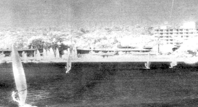
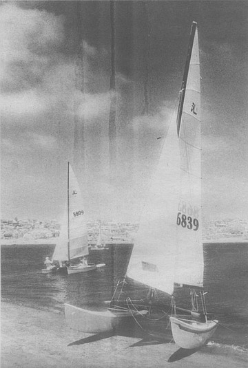
Sailboats on the bay. Earnest is convinced that Mission Bay is a relative newborn in geologic time.
When Les Earnest retired in 1971 as director of the San Diego Park and Recreation Department, the zoo’s Joan Embery brought a black brant to the retirement party at the U.S. Grant. The bird was a symbol of Earnest’s years overseeing the development of Mission Bay, a job he was appointed to in 1959. Hundreds of migrating black brants had once used the Rose Creek delta, in the northeast corner of the Mission Bay mud flats, as roosting grounds, and bird lovers had warned that dredging, construction, and road building in the De Anza Cove area would destroy the birds' habitat. “But all the birds did was move over to the area around the Bahia Hotel,” explains Earnest. The zoo’s brant still took the opportunity to give Earnest a message that brought gales of laughter from the assembled guests. It clamped its bill firmly onto Earnest’s thumb.
Mission Bay, c. 1956. In about 1950, Marian Marchant from Beverly Hills presented her idea for a trailer park on De Anza Point. Her see-through blouses tended to rivet the attention of the city fathers, as did her credit rating.
Les Earnest, who’s now 87, went to work for the city in 1947, just as the city fathers were looking for something other than war production on which to base the local economy, and city planner Glenn Rick was dusting off a 20-year-old plan for dredging Mission Bay and transforming it into a tourist mecca. Earnest worked in the city’s budget office throughout the 1950s, while the park’s master plan evolved, the bond issues were passed, private property around the bay was purchased or condemned, and piece by piece the park took shape. After completing a six-month assignment to integrate the nascent park into the city administration, Earnest became acting Mission Bay director in 1959. The next year, he was also made director of the city’s park and recreation department.
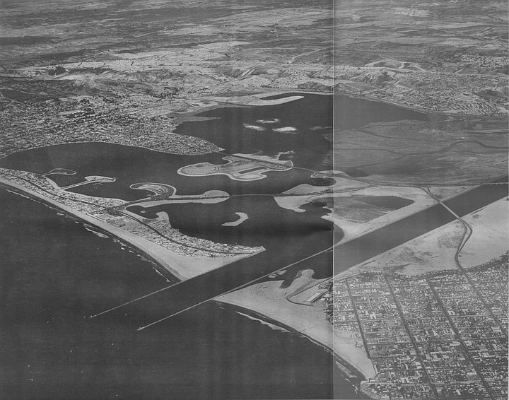
Map of Mission Bay. Virtually all of the sand and silt dredged from Mission Bay was redistributed elsewhere within the bay. Earnest says the only sand that was piped out of the park was dumped on Mission Beach.
Earlier this summer. Earnest agreed to give a waterborne tour of the park he helped create. As we cruised in a small boat around Mission Bay, he told stories of how the park came to look as it does today. Inspecting the area with him was like test-driving a lovingly restored jalopy while the man who did the job rode shotgun.
As we floated into De Anza Cove, Earnest explains that the northeast comer of the cove's shoreline was filled in with mud and sand dredged from the bay. Once that was done, in about 1950, city workers began trucking sewage sludge and dumping it there as fertilizer. The main sewage treatment plant was then located on the shore of San Diego Bay, near the foot of 28th Street. The city had tried to dry the sludge at the plant and market it commercially as fertilizer, but that idea fizzled when the wind blew away most of the product.
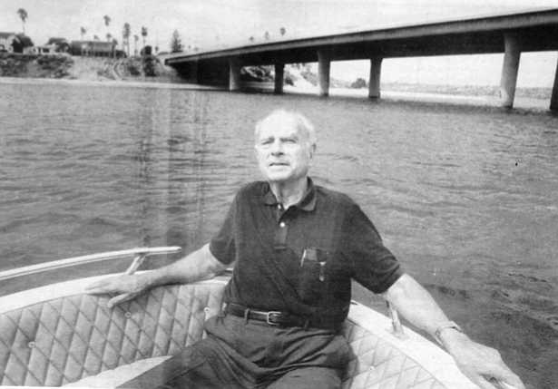
Les Earnest with Ingraham Street Bridge and Crown Point in the background. When Millay and his partners won the Sea World lease in 1961, their original architectural plans were horrible, says Earnest.
The city’s plan B was to use the sludge as fertilizer in its parks. But some local citizens objected to the notion of dumping sewage residue around Mission Bay.
“One day a guy came out to where the sludge was being dumped here and pushed the truck driver out of the way. He says,“You’re not going to dump that here,’ and he tries to shut off the valve. The sludge was hauled in wet and spread out in furrows to dry. But as the guy tries to shut off the valve, he slips in the sludge and goes down in it.” Earnest chuckles. “He never bothered us again.”
"As generations of Over-the-Line competitors have discovered, when the afternoon winds arise, Fiesta Island becomes a dust pit."
Once the new sewage treatment plant began operating on Point Loma in 1963, the sludge fertilizer had worked so well in Mission Bay (the whole east side of Vacation Isle was fertilized with sludge) that an eight-inch pipe was extended from the plant down Rosecrans to empty on the south side of the San Diego River flood-control channel, where two settling basins were located near the end of West Point Loma Boulevard. Later the line was extended across the channel to the newly created Fiesta Island.
The Quivira Basin breakwater was constructed to protect Quivira Basin. Since then, the wave energy has bounced back toward Mariner’s Point and eaten away at the beach.
The island’s sludge beds were supposed to have been a temporary staging point for another attempt to dry the sludge and bag it for commercial use. That half-hearted effort died when the need for fertilizer in city parks could not keep pace with the sludge production of the fast-growing city. “I kind of thought we could keep up with it, but it didn’t work out that way,” Earnest remarks. “I never envisioned those mountains of sludge taking up such a large part of the island.” In the new Mission Bay master plan, now in the early stages of being written, those sludge beds are to be moved near the city dump alongside NAS Miramar, and a hotel is being talked about for that part of Fiesta Island.
De Anza Cove. Bird lovers had warned that dredging, construction, and road building in the De Anza Cove area would destroy the birds' habitat. “But all the birds did was move over to the area around the Bahia Hotel."
Another semi-permanent feature of Mission Bay — the De Anza mobile home park — also devolved from a good idea into a civic embarrassment. Now the dwellings are recognized as a violation of provisions the city agreed to when the State of California deeded its 2900 acres of Mission Bay tidelands over to the city in 1945. The agreement prohibited any permanent residences on dedicated parkland. As we chum around De Anza Point and view some of the comically palatial “mobile” homes. Earnest relates how they came to be here.
In about 1950, he says, a Mrs. Marian Marchant from Beverly Hills arrived at city hall and presented her idea for building a trailer park on De Anza Point. She had just completed a nationwide tour of mobile home parks, “and she decided this is what she wanted to do.“ One morning at nine a.m. she arrived at the council conference in which the city council members, the city manager, the city attorney, various staffers, and the press met to discuss that day’s council docket. “She was not a bad-looking woman,” Earnest recalls. He remembers that her see-through blouses tended to rivet the attention of the city fathers, as did her credit rating. When city personnel checked with her Beverly Hills bank, they were told that her credit was “unlimited.” “It was the only time in my life I’ve ever seen a credit rating like that,” Earnest marvels.
“She made her pitch to the whole council, saying that leasing out this area for a trailer park would bring tourists to San Diego from all over the country. The council saw it as a way to get the bay off and running. She made a hell of an impression. But the council thought she was talking about trailers; they never dreamed it would become permanent housing.”
Whatever impression Mrs. Marchant made on the council, it worked. She received a 50-year lease on 68 acres of parkland. But as early as 1952, as the mobile home sites were being completed, she indicated to the local newspapers that her intent was for long-term residences in the park. In August of 1952, the San Diego Union reported, “The trailer park will cater to persons who are interested in year-round residence here, ’not just a holiday,’ [Mrs. Marchant] explained.” In subsequent years, the mobile home park became an irritant to many citizens, and the city made sure one section of it was set aside for only four-month residencies. When the final extension on the lease expires in 2005, the houses are supposed to be removed and the point may become marshland.
On that point, Earnest has some strong opinions. He has kept up on recent efforts to create a new Mission Bay master plan, and he doesn’t like some of what he’s seen — like the possibility that De Anza Point and the Rose Creek outlet will be turned back into marshland to improve water quality in the east bay. As we ease the boat up toward the rock-lined channel of Rose Creek, Earnest remarks, “Water quality problems in the bay are related to sewage breaks; street runoff into the creek is only a part of it. Marshland down here won’t clean up the water enough to make it worth destroying a major part of our bay.”
Slipping westward across the mouth of the Rose Creek inlet, behind Mission Bay High School, Earnest declares, “At one time we were going to put a bridge across the creek. There was going to be a footpath all the way around the bay.” But several commercial leasees such as De Anza, Campland on the Bay, and Sea World ended up blocking public access to the shoreline. And even today, several homeowners along Sail Bay treat the public beach in front of their homes as private property. The contiguous footpath idea was a victim of private interests.
Off to starboard is Campland, the pricey shoreside campground (as much as $50 a night to park an RV) that paid the city $772,000 in lease fees last year. In 1960 this area spent most of a year as a settling pond for raw sewage. “We called it Bean’s Pond,” Earnest explains. George Bean was San Diego city manager from 1957 to 1961. When the main sewer line serving the beach areas broke in the northeast comer of the bay. Bean decided that the effluent should be diverted into settling ponds on the mud flats at the end of Olney Street until the sewer main could be fixed. Decrepit sewage pipes continue breaking in the beach areas today, periodically rendering a waterski outing in bay waters a flirtation with hepatitis. Parts of the bay were closed to water contact for 1500 days (about four years’ worth of closures) between 1980 and 1988.
Abutting Campland is the 70-acre marsh called the Kendall-Frost Wildlife Preserve, the one piece of the 4600-acre park that was left in its original state. Although early plans for Mission Bay envisioned several such wildlife areas, with each succeeding plan update, the natural habitat shrank. A 1945 version of the plan included a long wildlife lagoon in the east bay ; later versions showed a small archipelago of wildlife islands southwest of De Anza Point. In the end, these were replaced by the waterskiing area of Fiesta Bay.
In 1951 the city had sought to condemn the Kendall marshlands at the foot of Olney Street for incorporation into the park; early plans called for a golf course on the site, an idea favored by group of Pacific Beach residents. But Mrs. Lena Kendall donated the marsh to the University of California's Scripps Institution of Oceanography for safekeeping. Carl Hubbs, the Scripps marine biologist, had lobbied against destruction of the marsh, which was a remnant of what had once been a 4000-acre feeding ground for the huge flocks of migrating black brants, as well as numerous other birds and fish. Hubbs saw it as one of the last remaining salt marshes in Southern California; virtually all of the state’s rivers had been dammed, and most of the coastal lagoons had been drained for commercial development or military use.
In his 1979 memoir about the development of the bay, Glenn Rick, the city planning director who oversaw most of the design process (he died in 1983), reports that in the late 1940s Scripps’s Roger Revelle had solicited the gift from Mrs. Kendall in hopes of using it for scientific experiments. “The idea was to ascertain if protein bearing grasses and plants could be grown in salt water,” Rick writes. “Fear had been expressed that future world needs might call for such feed for animals.”
Rick included a brief biographical reminiscence of Mrs. Kendall in his book:
- Mrs. Lena Kendall was a gracious lady who lived in a large two-story house on the north shore of Mission Bay. She once or twice told me the story about how she came to buy the land and build the house in which she lived. Toward evening one night she stood alone on the easterly shore of Crown Point and a white-gowned figure suddenly appeared behind her and pointed an arm toward the cast and said, “Buy that property." She did buy the property and lived on it for many years. On more than one occasion she would call me after a slight earthquake was felt and ask me to come out and inspect the results of the earthquake. The quake had disturbed the bay area and caused oil to come bubbling to the surface. It was not ordinary black oil, but pure refined Pennsylvania oil that spread itself over the water. She knew it was such because she had lived among the Texas oil fields and knew what she was talking about. By the time I drove out at her request, the oil had dispersed.
Earnest says he too was called out to see the oil by Mrs. Kendall. “The oil was a figment of her imagination,” he declares. “I went out on several occasions and spent more than an hour with her. She was very pleasant to talk to. She’d say. ‘See out there? The oil was shooting up like a geyser!’”
Rounding Crown Point prompts Earnest’s account of the bay’s opening-day ceremonies. April 24, 1962. According to Earnest, City Councilwoman Helen Cobb saw to it that City Manager Tom Fletcher and a couple of councilmen heaved him into the bay at the point.
As we pass beneath the Ingraham Street bridge, in the narrow channel between Crown Point and Vacation Isle, Earnest gestures toward the point’s sand beach and says, ‘The bay originally went all the way back to the slope there. The point dropped off straight into the bay. First thing we did, we set up the dredge pipe on floats and piped sand along Crown Point, building a little dike running back north and east, toward the Kendall reserve, and filled in behind it with material dredged from the western part of the bay. That’s good sand. Some of that material came from along the eastern edge of Tierra del Fuego — I mean Vacation Isle — Tierra del Fuego was the original name. Vacation Isle is about the dividing line between good sand on the bottom of the bay and all that fine silt to the east.”
The beach along the western curve of Crown Point was created by the private property owners who held leases on the beaches rimming Sail Bay, says Earnest. “They wanted to dredge out the northern shore of Sail Bay, and they needed some place to dump the spoil, so we let ’em put it on Crown Point.”
Virtually all of the sand and silt dredged from the bottom of Mission Bay was redistributed elsewhere within the bay. Earnest says the only sand that was piped out of the park was a relatively small amount dredged from San Juan and Santa Clara Coves and dumped on Mission Beach.
In 1926 the state harbor board controlled the area covered by Mission Bay Park. In that year, the board made several 50-year leases around Sail Bay. then known as Crescent Bay, theorizing that the best way to develop the park was to let private property owners do it. The leases extended from the high tide line into the water a couple of hundred feet. “But all they did was use the leases to provide themselves private access to the water,” Earnest says of the leaseholders. About 1920, John D. Spreckels received a permit to dredge out Bonita Cove, across the strand from his Belmont Park amusement center, to use as a bay-side swimming hole. He also dredged a narrow channel from Bonita Cove south to where the San Diego River trickled into the ocean. Shortly after that, the private leaseholders extended the channel north into Sail Bay so they could sail their boats out to the sea.
Eventually, the state canceled all but three of the private leases. One that was canceled belonged to a streetcar company that ran a rail line from Ocean Beach to La Jolla. The tracks crossed a bridge over the shallow mouth of the San Diego River on its way into South Mission Beach. According to Glenn Rick, the lease was withdrawn when the rail line was switched over to bus transportation. But the bridge connecting Ocean Beach and south Mission Beach remained in place until 1950. In February of 1946 its middle section was removed in order to bring the dredges into Mission Bay, and then the bridge was reassembled.
For O.Betians, that bridge connecting Mission Boulevard and Bacon Street was the main access route to the north and a popular fishing pier. “Ocean Beach fought us taking that bridge out,” Earnest recalls, “so the city had to draw up plans and pay for the bridge connecting Sea World Drive and Sunset Cliffs Boulevard.”
The three main leases that were kept active in the Sail Bay area were known as the Scripps lease, which was held by Tom Scripps and was acquired in the mid-1950s by Bill Evans, whose Catamaran Hotel needed it for beach space; the Crescent Bay lease, held by a group of 17 local property owners; and the Crown Point lease, which extended from the western end of Moorland Street all the way around the point to the eastern end of Moorland Street, which was also held by local property owners. The Crescent Bay and Scripps leases expired in 1976 and were not renewed. But the Crown Point lease became a major stumbling block to the city’s acquisition of all the land around the shoreline. A unified park covering such a large area required that ownership questions be resolved.
Houses and shacks had existed close to Mission Bay since the early 1800s; the best-known community was called Duckville, a motley collection of hunting and fishing shanties on the river delta near the end of what is now Friars Road, one-half mile east of Sea World. The 100-year flood of 1916, which produced enough runoff to fill Mission Valley from bank to bank (and may do so again someday) wiped it out.
An area called Pike’s airfield was one sizeable concentration of houses and shacks still around in 1945, when Glenn Rick suggested that the city administration begin condemnation proceedings on about 1000 pieces of bayside property for nonpayment of taxes. Pike’s airfield was located in the southeast section of the bayshore, near the present-day Fiesta Island access road. Les Earnest says one of his tasks was to inform the settlers in the Pike’s airfield area that they had to move. “I was the grim reaper,” he recalls. “There was one guy in there who had about 17 acres, with pigs and a dog track. He never had clear title. And if your taxes were five years in arrears, the city could take the property on tax title. Nobody really fought it.”
The city also needed to obtain the Crown Point lease, because the park required public control of the entire shoreline. And the Crown Point leaseholders were talking about building a hotel on the western shore, facing Sail Bay. Earnest says a hotel there would have caused a serious traffic problem and did not fit into the plans for the park. Like many of the leases, the Crown Point lease had not been kept current in payments to the state. The lease was held by Mr. C.C. Pease, an attorney who had acquired it from a group of Crown Point property owners. In 1945, as the city was endeavoring to pass the first $2 million bond issue for development of the bay, city staffers requested that the state refuse to accept past-due rental payments on that lease. Pease was notified that his lease was canceled for nonpayment of rent.
According to Les Earnest. Pease sent in his back rent to the state anyway, and an unknowing clerk deposited it and brought the lease current again. Glenn Rick's book has a slightly different account. ‘‘[Pease] went to the State and convinced it to accept payments bringing the lease up to date,” Rick wrote. “In the meantime, the city had served notice on Mr. Pease that his lease was canceled. A court case decided in favor of Mr. Pease. It was reported that the mayor, on a visit to Sacramento, had a near fistfight with the state official who took the rental payment and put the lease in good standing.” Earnest says that would have to be Mayor Harley Knox, “a short, stocky guy who’d run a dairy farm all his life.” So the city was trumped. Eventually Pease sold his lease, which covered 6800 feet of bay frontage around Crown Point, to Tucson-based hotel magnate Del Webb, the one-time owner of the New York Yankees, but by then only 17 years remained on the lease. Webb was determined to build a major hotel on Mission Bay, so the city cut a deal with him: He would get a 50-year lease on a large hotel site next to U.S. 101 (now I-5) in the east bay, and the city would buy out his Crown Point lease for $125,000. Webb agreed to the deal on January 21, 1960 — coincidentally, the same day Les Earnest was named Mission Bay Park director. Three years later he opened Del Webb’s Ocean House, which was later sold to the Hilton chain.
Our little boat motored into Sail Bay just as the early summer sunlight turned from silver to brass. In the late 1940s one of the dredges broke a $10,000 drill bit when it struck sandstone boulders in here. Earnest says, which to him was further evidence of “my theory that this” — he sweeps his hand back toward Crown Point — “was once the original shoreline.”
Earnest is convinced that Mission Bay, which Juan Cabrillo's landing party named False Bay when they came upon its tidal flats in 1542, is a relative newborn in geologic time. He believes that Point Loma and North Island were originally islands, and the shoreline scalloped back all the way along what is now the eastern edge of Mission bay and across the river to the area around Rosecrans and Sports Arena Boulevard. The ocean currents circulate southward off what is now La Jolla. Pacific Beach, Mission Beach, and Ocean Beach, and over time enormous sand bars accumulated in front of the sprawling San Diego River delta. When Junipero Serra arrived to establish the mission in 1769, the river was then emptying into False Bay. A major flood that year carved a channel into San Diego Bay and diverted the river in that direction, demonstrating the alternating outflow that must have gone on for hundreds of thousands of years. Eventually the buildup of river silt helped the ocean currents to find a foothold for creation of a strand of deep sand trending south from about where Pacific Beach Drive hits the beach. Similarly, the northward circulating currents outside San Diego Bay piled up sand that became the Silver Strand and turned what had been North Island into a peninsula.
In constructing the various points, islands, and bays of Mission Bay Park, “We wanted to start with the best material we had to work with,” Earnest explains. So soil samples were taken throughout the bay. Testing revealed that all the good sand was deposited west of Ingraham Street, and everything else to the east was fine, muddy silt laid down by the San Diego River, Rose Creek, and Tecolote Creek, which drain 57 square miles of watershed. The first dredging contract was for the construction of Bahia Point, where the Bahia Hotel is now located; creation of the western end of what is now Vacation Isle; and the pumping of sand from Bonita Cove to the northeast comer of the bay for the construction of De Anza Point. By that time the Army Corps of Engineers had completed construction of the south and middle jetties of the San Diego River flood control channel, using granite boulders from Mission Gorge. The north jetty, forming the entrance to Mission Bay, wasn't completed until 1950.
By 1956, when the third Mission Bay bond issue was passed by the voters. Earnest says people were starting to complain about having spent so much money just to move mud and water. “All you could see was some fishing boats and the dredges — there was no landscaping.” The $5 million bond issue was originally intended to be split, one half for more dredging and the other for landscaping. But with the end in sight for the dredging — the completion of Fiesta Island and the eastern shoreline — city engineer Ed Gabrielson had another idea. “Ed said, ‘Let’s do two bids,’ ” Earnest recalls, “‘this job — what we can get for two and a half million — and a proposal for completing the rest of the dredging.’ A company from Sioux City, Iowa, that wanted to get a foothold on the West Coast, turned in a bid to do all the dredging, the whole thing, for a little over $5 million. So we took the bond money, added two or three hundred thousand more from capital outlay funds, and gave ’em the whole job. It saved the city several million dollars.” The city had paid 75 cents a cubic yard for dredging some parts of the bay; the $5 million bid worked out to about 35 cents a cubic yard, even though the Iowa company had their dredge towed down the Missouri River, the Mississippi, and through the Panama Canal to get to the job site in San Diego.
The dredging was completed by the end of 1961, but the park’s landscaping was still missing. However, the next time the city went to the electorate for bond money, the $12.5 million request was defeated. This was 1962, “And several people weren’t convinced we were making a park of it.” Earnest remarks. “After spending $9 million, it still looked a mess.” Four years later, bonds were passed for improvements in all of the city’s parks, including Mission Bay.
Concurrent with the park’s money troubles, the hydrodynamic patterns of the new bay began to reveal themselves. Tidal action ate away at some areas, such as the north end of Carmel Point, and silted up others, such as the channel between Bahia Point and Vacation Isle. "We learned that if you have a sand beach, you need a long slope, not steep, otherwise it will be washed away,” says Earnest. This was an early and continuing problem with the beachfront behind the Bahia Hotel facing Vacation Isle. Ever since the bay was completed, sand has had to be dragged back up onto the beach to keep the perimeter road and landscaping from being undermined. The only way to stop the erosion would be to build groins extending out into the water, which is problematical in such a narrow channel.
Similarly, it was discovered that tidal action could erode sand from behind rock revetments. As we ease our boat along the western shore of Vacation Isle, Earnest gestures toward the gray boulders lining that side of the island. “When the sand started disappearing from behind those boulders, we realized you couldn't just dump big boulders to protect a beach. You had to start with smaller rock, like gravel, then bigger rock, then the boulders. The same thing happened when the north jetty went in alongside South Mission Beach. The sand started seeping through the jetty from South Mission. Eventually a large part of that beach would have been washed away, so in about 1961 we had to go in and pump grout and concrete down into the jetty.”
Another kind of scouring resulted from the ricochet of wave and tidal energy as it bounds down the Mission Bay channel and strikes Hospitality Point, just below the lifeguard headquarters. This wasn’t a serious problem until the channel was dredged to a depth of 20 feet in the late 1960s (it had originally been only 8 feet deep from the mean low tide line, like the rest of the bay), and the breakwater was constructed to protect Quivira Basin. Since then, the wave energy has bounced back toward Mariner’s Point and eaten away at the beach on the inside of Mariner’s Basin. A large amount of sand was lost from the western edge of Mariner’s Point, but the erosion seems to have ceased now that the currents have reconfigured the point.
In the Mission Bay channel, we watched as a sportfishing boat bristling with rods churned out toward the sea, then we turned back and faced Hospitality Point, “Right there is where we wanted to put a restaurant/' Earnest declares, indicating a vacant plot of land at the terminus of Quivira Way. “The only person interested was George Joe, the Chinese restauranteur who'd had a Chinese restaurant at the '35 Exposition. He’d owned several restaurants around town, but he didn't have the money to build one here. Plus, there’s an access problem. This is pretty far out of the way.” Several ideas for the bay didn’t make it to reality: bridle paths encircling the park; a gun club in the area near where 1-8 now crosses West Mission Bay Drive; a drive-in theater in the northeast comer of the park and a small bay side stadium. One early idea that was discarded was to make different areas of the park conform to some Pacific theme, such as Polynesian, Japanese, and Pacific Northwest. One of the weirder brainstorms came from Bill Evans, owner of the Bahia and a major stockholder in the Catamaran, who wanted to build a floating island that would shuttle between the two hotels and would feature a 30-foot-tall volcano spewing steam. The island would also include a waterfall, palm trees, and a grass hut cocktail lounge and would be manned by a crew dressed in pirate garb. Although the Mission Bay Park Commission was receptive to the idea, Evans had second thoughts and acquired paddlewheelers instead.
Sea World almost didn’t come into being. As we head east and cross back under the Ingraham Street bridge. Earnest explains, “At first the federal government wanted their VOR station down where Sea World is, and they didn’t want any activity within a half a mile of it. That would have killed us.” The VOR station, a navigational aid for airplane traffic, is that white cone-shaped transmitter in the bay west of Fiesta Island. “We sweated it out and finally conned the government into putting it on that little island.”
A marine aquarium had always been in the plans for Mission Bay, and it was believed that such an attraction would only need 15 acres of land. The park planners never imagined that Sea World would gobble up 150 acres of the park (and it’s lobbying for an additional 50 acres for overflow parking) and convert living marine animals into major revenue producers for the city. (Sea World’s lease payments to the city last year totaled about $4 million, almost one-third of all the lease revenue generated in the park; it will be $5 million in the year 2001.) But when proposals for the theme park were solicited, one idea had obvious possibilities: “The Sea World proposal included dolphin races with monkeys as jockeys,” Earnest recalls.
The most intense pressure for the lease came from a group of local developers who wanted 75 acres of land for their theme park. “But we said that was too much land.” Earnest recalls now, chuckling. The group that was awarded the lease was headed by George Millay, who was bom in Ocean Beach but raised in Long Beach. He spent time in the Navy, attended UCLA, and had established a successful restaurant on Terminal Island. He had wanted to build part of that restaurant underwater, so diners could gaze at fish while they ate, but poor underwater visibility.off Long Beach made that impossible. When Millay and his partners won the Sea World lease in 1961, their original architectural plans were horrible, says Earnest. “Structurally it was ideal, but it was not aesthetic.” They had hired a firm in Long Beach that specialized in waterfront construction, specifically piers and docks. When the city rejected the plans, Millay and Earnest visited an architectural consulting firm in Pasadena that had written a report for the city on architecture around Mission Bay, and Millay was considerably enlightened. He hired architects from back East to do the design work. “The only thing that group didn’t design was the Japanese garden,” Earnest explains. “That was designed in Japan, and all the lumber was cut and shaped over there, wrapped in paper, and shipped to San Diego. There was a Japanese Ph.D. landscape architect George wanted to do the planting, but he couldn’t come over unless he was requested by the government. So I wrote them a letter, and they let him come put the garden in.”
Our boat pulled up alongside Fiesta Island, which isn’t really an island because of the causeway connecting it to East Mission Bay Drive. Earnest says that early plans called for bridges to be built at the northern and southern points of the island, allowing access to the island for an automobile racecourse. The spectators would have watched the action from grandstands on the island, inside the racecourse. “This was at the same time when we built the Torrey Pines golf course,” Earnest explains. “There had been a racecourse up there, and it had to be removed, and the people who ran it thought we should put it in Mission Bay. But we thought everything in the bay should be water oriented.” The racecourse idea met the same fate as the seaplane landing that area planners had imagined nearby, just off the beach from what is now the Hilton.
Fiesta Island was the next-to-last feature to be constructed (the fill beneath Sea World was the final job), and by then traffic patterns and landscaping had been established along the eastern shoreline, making the bridges problematical. Plus “We were running out of money,” Earnest recalls. The bridges were erased from the final plans, and an inexpensive causeway was constructed.
The loss of water circulation around the island has contributed to the poor water quality in the east bay. Pollutants brought down by storm drains and Tecolote and Rose Creeks tend to linger there in the still waters. In the future, the island may be cut into three main sections to allow more flushing action.
“If we knew then what we know now, we’d have done Fiesta Island a little differently,” Earnest reflects. “We would have used two dredges at a time and mixed the west bay sand with the east bay muck to fill Fiesta Island.” As generations of over-the-Line competitors have discovered, when the afternoon winds arise, Fiesta Island becomes a dust pit. Only the perimeter of the island, its beach and berm, was formed with sand, most of it pumped across the bay starting in 1959 from Quivira Basin. The body of the island was made from the muck dredged from the immediate vicinity. This clay-like silt blows around and is not a good base for holding vegetation. Although Fiesta Island was planned as one of the bay’s wildlife areas, the thin, dusty soil has stunted that idea.
The shape of Fiesta Island was determined by two factors: All the dredged material from the bay had to be dumped somewhere, so the island had to be very big, and a decision was made early that an aquatic park needed the maximum amount of shoreline. In the late 1940s, planning director Glenn Rick had been sent by the city on an inspection tour of waterfront developments all over the U.S. Although his itinerary included Portland, Seattle, Minneapolis, Milwaukee, Detroit, Chicago, New York City, Boston, and Miami, Rick wrote, “Nowhere on the tour did I find more helpful information than I did at Newport Harbor.... There is a similarity of development because both areas had to go to the state to get control of water rights. The climate and tidal action are the same in each case and the closeness to the fishing grounds of the Pacific made them similar, and both appeal to about the same general class of people.” In Chicago, Rick had noted that the lakefront yacht basin had appealed to “the wealthy rather than the common man.” After several trips to Newport to view its harbor and talk with city planner L. Deming Tilton, “who repeatedly urged the creation of peninsulas and islands which could be designed to offer the greatest amount of shoreline,” Rick came home with a vision for the east bay that evolved into the points and coves of Fiesta Island.
Such a scheme was also envisioned for the east bay shoreline, but it was changed to a straight line during the bay’s construction. The city had been informed by scientists from Scripps and from Woods Hole Oceanographic Institute in Massachusetts that the planned “unnatural shapes” of the eastern shoreline would eventually be eroded and filled by tidal forces to something approximating a straight line. On that advice, the shoreline was built straight. “But we had two storm drains coming across the beach, south of where the information booth is, and we didn’t want that drainage just pouring across the land there,” says Earnest, pointing from the boat to the nearby eastern shoreline, “so in the late 1960s we built Paradise Cove to prevent the storm waters from messing up the park.” Another small cove was cut into the shore just to the north of Paradise Cove for the other storm drain, and suddenly the eastern shore looked like it did in the original plans. And since there’s no real water circulation around Fiesta Island, so far. Earnest observes, the scientific predictions about the shoreline straightening itself out haven’t proved true. Maybe that would change if Fiesta Island is segmented and circulation is improved, but Earnest, based on his experience in Mission Bay, isn’t making any predictions. “You have an idea,” he observes, “and sometimes it works. But sometimes it doesn’t.”
Here's something you might be interested in.
Mission Bay: pirates, dolphin races, volcanoes, and see-through blouses
All the good sand was deposited west of Ingraham Street
Mission Bay: pirates, dolphin races, volcanoes, and see-through blouses
All the good sand was deposited west of Ingraham Street
Sailboats on the bay. Earnest is convinced that Mission Bay is a relative newborn in geologic time.
When Les Earnest retired in 1971 as director of the San Diego Park and Recreation Department, the zoo’s Joan Embery brought a black brant to the retirement party at the U.S. Grant. The bird was a symbol of Earnest’s years overseeing the development of Mission Bay, a job he was appointed to in 1959. Hundreds of migrating black brants had once used the Rose Creek delta, in the northeast corner of the Mission Bay mud flats, as roosting grounds, and bird lovers had warned that dredging, construction, and road building in the De Anza Cove area would destroy the birds' habitat. “But all the birds did was move over to the area around the Bahia Hotel,” explains Earnest. The zoo’s brant still took the opportunity to give Earnest a message that brought gales of laughter from the assembled guests. It clamped its bill firmly onto Earnest’s thumb.
Mission Bay, c. 1956. In about 1950, Marian Marchant from Beverly Hills presented her idea for a trailer park on De Anza Point. Her see-through blouses tended to rivet the attention of the city fathers, as did her credit rating.
Les Earnest, who’s now 87, went to work for the city in 1947, just as the city fathers were looking for something other than war production on which to base the local economy, and city planner Glenn Rick was dusting off a 20-year-old plan for dredging Mission Bay and transforming it into a tourist mecca. Earnest worked in the city’s budget office throughout the 1950s, while the park’s master plan evolved, the bond issues were passed, private property around the bay was purchased or condemned, and piece by piece the park took shape. After completing a six-month assignment to integrate the nascent park into the city administration, Earnest became acting Mission Bay director in 1959. The next year, he was also made director of the city’s park and recreation department.
Map of Mission Bay. Virtually all of the sand and silt dredged from Mission Bay was redistributed elsewhere within the bay. Earnest says the only sand that was piped out of the park was dumped on Mission Beach.
Earlier this summer. Earnest agreed to give a waterborne tour of the park he helped create. As we cruised in a small boat around Mission Bay, he told stories of how the park came to look as it does today. Inspecting the area with him was like test-driving a lovingly restored jalopy while the man who did the job rode shotgun.
As we floated into De Anza Cove, Earnest explains that the northeast comer of the cove's shoreline was filled in with mud and sand dredged from the bay. Once that was done, in about 1950, city workers began trucking sewage sludge and dumping it there as fertilizer. The main sewage treatment plant was then located on the shore of San Diego Bay, near the foot of 28th Street. The city had tried to dry the sludge at the plant and market it commercially as fertilizer, but that idea fizzled when the wind blew away most of the product.
Les Earnest with Ingraham Street Bridge and Crown Point in the background. When Millay and his partners won the Sea World lease in 1961, their original architectural plans were horrible, says Earnest.
The city’s plan B was to use the sludge as fertilizer in its parks. But some local citizens objected to the notion of dumping sewage residue around Mission Bay.
“One day a guy came out to where the sludge was being dumped here and pushed the truck driver out of the way. He says,“You’re not going to dump that here,’ and he tries to shut off the valve. The sludge was hauled in wet and spread out in furrows to dry. But as the guy tries to shut off the valve, he slips in the sludge and goes down in it.” Earnest chuckles. “He never bothered us again.”
"As generations of Over-the-Line competitors have discovered, when the afternoon winds arise, Fiesta Island becomes a dust pit."
Once the new sewage treatment plant began operating on Point Loma in 1963, the sludge fertilizer had worked so well in Mission Bay (the whole east side of Vacation Isle was fertilized with sludge) that an eight-inch pipe was extended from the plant down Rosecrans to empty on the south side of the San Diego River flood-control channel, where two settling basins were located near the end of West Point Loma Boulevard. Later the line was extended across the channel to the newly created Fiesta Island.
The Quivira Basin breakwater was constructed to protect Quivira Basin. Since then, the wave energy has bounced back toward Mariner’s Point and eaten away at the beach.
The island’s sludge beds were supposed to have been a temporary staging point for another attempt to dry the sludge and bag it for commercial use. That half-hearted effort died when the need for fertilizer in city parks could not keep pace with the sludge production of the fast-growing city. “I kind of thought we could keep up with it, but it didn’t work out that way,” Earnest remarks. “I never envisioned those mountains of sludge taking up such a large part of the island.” In the new Mission Bay master plan, now in the early stages of being written, those sludge beds are to be moved near the city dump alongside NAS Miramar, and a hotel is being talked about for that part of Fiesta Island.
De Anza Cove. Bird lovers had warned that dredging, construction, and road building in the De Anza Cove area would destroy the birds' habitat. “But all the birds did was move over to the area around the Bahia Hotel."
Another semi-permanent feature of Mission Bay — the De Anza mobile home park — also devolved from a good idea into a civic embarrassment. Now the dwellings are recognized as a violation of provisions the city agreed to when the State of California deeded its 2900 acres of Mission Bay tidelands over to the city in 1945. The agreement prohibited any permanent residences on dedicated parkland. As we chum around De Anza Point and view some of the comically palatial “mobile” homes. Earnest relates how they came to be here.
In about 1950, he says, a Mrs. Marian Marchant from Beverly Hills arrived at city hall and presented her idea for building a trailer park on De Anza Point. She had just completed a nationwide tour of mobile home parks, “and she decided this is what she wanted to do.“ One morning at nine a.m. she arrived at the council conference in which the city council members, the city manager, the city attorney, various staffers, and the press met to discuss that day’s council docket. “She was not a bad-looking woman,” Earnest recalls. He remembers that her see-through blouses tended to rivet the attention of the city fathers, as did her credit rating. When city personnel checked with her Beverly Hills bank, they were told that her credit was “unlimited.” “It was the only time in my life I’ve ever seen a credit rating like that,” Earnest marvels.
“She made her pitch to the whole council, saying that leasing out this area for a trailer park would bring tourists to San Diego from all over the country. The council saw it as a way to get the bay off and running. She made a hell of an impression. But the council thought she was talking about trailers; they never dreamed it would become permanent housing.”
Whatever impression Mrs. Marchant made on the council, it worked. She received a 50-year lease on 68 acres of parkland. But as early as 1952, as the mobile home sites were being completed, she indicated to the local newspapers that her intent was for long-term residences in the park. In August of 1952, the San Diego Union reported, “The trailer park will cater to persons who are interested in year-round residence here, ’not just a holiday,’ [Mrs. Marchant] explained.” In subsequent years, the mobile home park became an irritant to many citizens, and the city made sure one section of it was set aside for only four-month residencies. When the final extension on the lease expires in 2005, the houses are supposed to be removed and the point may become marshland.
On that point, Earnest has some strong opinions. He has kept up on recent efforts to create a new Mission Bay master plan, and he doesn’t like some of what he’s seen — like the possibility that De Anza Point and the Rose Creek outlet will be turned back into marshland to improve water quality in the east bay. As we ease the boat up toward the rock-lined channel of Rose Creek, Earnest remarks, “Water quality problems in the bay are related to sewage breaks; street runoff into the creek is only a part of it. Marshland down here won’t clean up the water enough to make it worth destroying a major part of our bay.”
Slipping westward across the mouth of the Rose Creek inlet, behind Mission Bay High School, Earnest declares, “At one time we were going to put a bridge across the creek. There was going to be a footpath all the way around the bay.” But several commercial leasees such as De Anza, Campland on the Bay, and Sea World ended up blocking public access to the shoreline. And even today, several homeowners along Sail Bay treat the public beach in front of their homes as private property. The contiguous footpath idea was a victim of private interests.
Off to starboard is Campland, the pricey shoreside campground (as much as $50 a night to park an RV) that paid the city $772,000 in lease fees last year. In 1960 this area spent most of a year as a settling pond for raw sewage. “We called it Bean’s Pond,” Earnest explains. George Bean was San Diego city manager from 1957 to 1961. When the main sewer line serving the beach areas broke in the northeast comer of the bay. Bean decided that the effluent should be diverted into settling ponds on the mud flats at the end of Olney Street until the sewer main could be fixed. Decrepit sewage pipes continue breaking in the beach areas today, periodically rendering a waterski outing in bay waters a flirtation with hepatitis. Parts of the bay were closed to water contact for 1500 days (about four years’ worth of closures) between 1980 and 1988.
Abutting Campland is the 70-acre marsh called the Kendall-Frost Wildlife Preserve, the one piece of the 4600-acre park that was left in its original state. Although early plans for Mission Bay envisioned several such wildlife areas, with each succeeding plan update, the natural habitat shrank. A 1945 version of the plan included a long wildlife lagoon in the east bay ; later versions showed a small archipelago of wildlife islands southwest of De Anza Point. In the end, these were replaced by the waterskiing area of Fiesta Bay.
In 1951 the city had sought to condemn the Kendall marshlands at the foot of Olney Street for incorporation into the park; early plans called for a golf course on the site, an idea favored by group of Pacific Beach residents. But Mrs. Lena Kendall donated the marsh to the University of California's Scripps Institution of Oceanography for safekeeping. Carl Hubbs, the Scripps marine biologist, had lobbied against destruction of the marsh, which was a remnant of what had once been a 4000-acre feeding ground for the huge flocks of migrating black brants, as well as numerous other birds and fish. Hubbs saw it as one of the last remaining salt marshes in Southern California; virtually all of the state’s rivers had been dammed, and most of the coastal lagoons had been drained for commercial development or military use.
In his 1979 memoir about the development of the bay, Glenn Rick, the city planning director who oversaw most of the design process (he died in 1983), reports that in the late 1940s Scripps’s Roger Revelle had solicited the gift from Mrs. Kendall in hopes of using it for scientific experiments. “The idea was to ascertain if protein bearing grasses and plants could be grown in salt water,” Rick writes. “Fear had been expressed that future world needs might call for such feed for animals.”
Rick included a brief biographical reminiscence of Mrs. Kendall in his book:
- Mrs. Lena Kendall was a gracious lady who lived in a large two-story house on the north shore of Mission Bay. She once or twice told me the story about how she came to buy the land and build the house in which she lived. Toward evening one night she stood alone on the easterly shore of Crown Point and a white-gowned figure suddenly appeared behind her and pointed an arm toward the cast and said, “Buy that property." She did buy the property and lived on it for many years. On more than one occasion she would call me after a slight earthquake was felt and ask me to come out and inspect the results of the earthquake. The quake had disturbed the bay area and caused oil to come bubbling to the surface. It was not ordinary black oil, but pure refined Pennsylvania oil that spread itself over the water. She knew it was such because she had lived among the Texas oil fields and knew what she was talking about. By the time I drove out at her request, the oil had dispersed.
Earnest says he too was called out to see the oil by Mrs. Kendall. “The oil was a figment of her imagination,” he declares. “I went out on several occasions and spent more than an hour with her. She was very pleasant to talk to. She’d say. ‘See out there? The oil was shooting up like a geyser!’”
Rounding Crown Point prompts Earnest’s account of the bay’s opening-day ceremonies. April 24, 1962. According to Earnest, City Councilwoman Helen Cobb saw to it that City Manager Tom Fletcher and a couple of councilmen heaved him into the bay at the point.
As we pass beneath the Ingraham Street bridge, in the narrow channel between Crown Point and Vacation Isle, Earnest gestures toward the point’s sand beach and says, ‘The bay originally went all the way back to the slope there. The point dropped off straight into the bay. First thing we did, we set up the dredge pipe on floats and piped sand along Crown Point, building a little dike running back north and east, toward the Kendall reserve, and filled in behind it with material dredged from the western part of the bay. That’s good sand. Some of that material came from along the eastern edge of Tierra del Fuego — I mean Vacation Isle — Tierra del Fuego was the original name. Vacation Isle is about the dividing line between good sand on the bottom of the bay and all that fine silt to the east.”
The beach along the western curve of Crown Point was created by the private property owners who held leases on the beaches rimming Sail Bay, says Earnest. “They wanted to dredge out the northern shore of Sail Bay, and they needed some place to dump the spoil, so we let ’em put it on Crown Point.”
Virtually all of the sand and silt dredged from the bottom of Mission Bay was redistributed elsewhere within the bay. Earnest says the only sand that was piped out of the park was a relatively small amount dredged from San Juan and Santa Clara Coves and dumped on Mission Beach.
In 1926 the state harbor board controlled the area covered by Mission Bay Park. In that year, the board made several 50-year leases around Sail Bay. then known as Crescent Bay, theorizing that the best way to develop the park was to let private property owners do it. The leases extended from the high tide line into the water a couple of hundred feet. “But all they did was use the leases to provide themselves private access to the water,” Earnest says of the leaseholders. About 1920, John D. Spreckels received a permit to dredge out Bonita Cove, across the strand from his Belmont Park amusement center, to use as a bay-side swimming hole. He also dredged a narrow channel from Bonita Cove south to where the San Diego River trickled into the ocean. Shortly after that, the private leaseholders extended the channel north into Sail Bay so they could sail their boats out to the sea.
Eventually, the state canceled all but three of the private leases. One that was canceled belonged to a streetcar company that ran a rail line from Ocean Beach to La Jolla. The tracks crossed a bridge over the shallow mouth of the San Diego River on its way into South Mission Beach. According to Glenn Rick, the lease was withdrawn when the rail line was switched over to bus transportation. But the bridge connecting Ocean Beach and south Mission Beach remained in place until 1950. In February of 1946 its middle section was removed in order to bring the dredges into Mission Bay, and then the bridge was reassembled.
For O.Betians, that bridge connecting Mission Boulevard and Bacon Street was the main access route to the north and a popular fishing pier. “Ocean Beach fought us taking that bridge out,” Earnest recalls, “so the city had to draw up plans and pay for the bridge connecting Sea World Drive and Sunset Cliffs Boulevard.”
The three main leases that were kept active in the Sail Bay area were known as the Scripps lease, which was held by Tom Scripps and was acquired in the mid-1950s by Bill Evans, whose Catamaran Hotel needed it for beach space; the Crescent Bay lease, held by a group of 17 local property owners; and the Crown Point lease, which extended from the western end of Moorland Street all the way around the point to the eastern end of Moorland Street, which was also held by local property owners. The Crescent Bay and Scripps leases expired in 1976 and were not renewed. But the Crown Point lease became a major stumbling block to the city’s acquisition of all the land around the shoreline. A unified park covering such a large area required that ownership questions be resolved.
Houses and shacks had existed close to Mission Bay since the early 1800s; the best-known community was called Duckville, a motley collection of hunting and fishing shanties on the river delta near the end of what is now Friars Road, one-half mile east of Sea World. The 100-year flood of 1916, which produced enough runoff to fill Mission Valley from bank to bank (and may do so again someday) wiped it out.
An area called Pike’s airfield was one sizeable concentration of houses and shacks still around in 1945, when Glenn Rick suggested that the city administration begin condemnation proceedings on about 1000 pieces of bayside property for nonpayment of taxes. Pike’s airfield was located in the southeast section of the bayshore, near the present-day Fiesta Island access road. Les Earnest says one of his tasks was to inform the settlers in the Pike’s airfield area that they had to move. “I was the grim reaper,” he recalls. “There was one guy in there who had about 17 acres, with pigs and a dog track. He never had clear title. And if your taxes were five years in arrears, the city could take the property on tax title. Nobody really fought it.”
The city also needed to obtain the Crown Point lease, because the park required public control of the entire shoreline. And the Crown Point leaseholders were talking about building a hotel on the western shore, facing Sail Bay. Earnest says a hotel there would have caused a serious traffic problem and did not fit into the plans for the park. Like many of the leases, the Crown Point lease had not been kept current in payments to the state. The lease was held by Mr. C.C. Pease, an attorney who had acquired it from a group of Crown Point property owners. In 1945, as the city was endeavoring to pass the first $2 million bond issue for development of the bay, city staffers requested that the state refuse to accept past-due rental payments on that lease. Pease was notified that his lease was canceled for nonpayment of rent.
According to Les Earnest. Pease sent in his back rent to the state anyway, and an unknowing clerk deposited it and brought the lease current again. Glenn Rick's book has a slightly different account. ‘‘[Pease] went to the State and convinced it to accept payments bringing the lease up to date,” Rick wrote. “In the meantime, the city had served notice on Mr. Pease that his lease was canceled. A court case decided in favor of Mr. Pease. It was reported that the mayor, on a visit to Sacramento, had a near fistfight with the state official who took the rental payment and put the lease in good standing.” Earnest says that would have to be Mayor Harley Knox, “a short, stocky guy who’d run a dairy farm all his life.” So the city was trumped. Eventually Pease sold his lease, which covered 6800 feet of bay frontage around Crown Point, to Tucson-based hotel magnate Del Webb, the one-time owner of the New York Yankees, but by then only 17 years remained on the lease. Webb was determined to build a major hotel on Mission Bay, so the city cut a deal with him: He would get a 50-year lease on a large hotel site next to U.S. 101 (now I-5) in the east bay, and the city would buy out his Crown Point lease for $125,000. Webb agreed to the deal on January 21, 1960 — coincidentally, the same day Les Earnest was named Mission Bay Park director. Three years later he opened Del Webb’s Ocean House, which was later sold to the Hilton chain.
Our little boat motored into Sail Bay just as the early summer sunlight turned from silver to brass. In the late 1940s one of the dredges broke a $10,000 drill bit when it struck sandstone boulders in here. Earnest says, which to him was further evidence of “my theory that this” — he sweeps his hand back toward Crown Point — “was once the original shoreline.”
Earnest is convinced that Mission Bay, which Juan Cabrillo's landing party named False Bay when they came upon its tidal flats in 1542, is a relative newborn in geologic time. He believes that Point Loma and North Island were originally islands, and the shoreline scalloped back all the way along what is now the eastern edge of Mission bay and across the river to the area around Rosecrans and Sports Arena Boulevard. The ocean currents circulate southward off what is now La Jolla. Pacific Beach, Mission Beach, and Ocean Beach, and over time enormous sand bars accumulated in front of the sprawling San Diego River delta. When Junipero Serra arrived to establish the mission in 1769, the river was then emptying into False Bay. A major flood that year carved a channel into San Diego Bay and diverted the river in that direction, demonstrating the alternating outflow that must have gone on for hundreds of thousands of years. Eventually the buildup of river silt helped the ocean currents to find a foothold for creation of a strand of deep sand trending south from about where Pacific Beach Drive hits the beach. Similarly, the northward circulating currents outside San Diego Bay piled up sand that became the Silver Strand and turned what had been North Island into a peninsula.
In constructing the various points, islands, and bays of Mission Bay Park, “We wanted to start with the best material we had to work with,” Earnest explains. So soil samples were taken throughout the bay. Testing revealed that all the good sand was deposited west of Ingraham Street, and everything else to the east was fine, muddy silt laid down by the San Diego River, Rose Creek, and Tecolote Creek, which drain 57 square miles of watershed. The first dredging contract was for the construction of Bahia Point, where the Bahia Hotel is now located; creation of the western end of what is now Vacation Isle; and the pumping of sand from Bonita Cove to the northeast comer of the bay for the construction of De Anza Point. By that time the Army Corps of Engineers had completed construction of the south and middle jetties of the San Diego River flood control channel, using granite boulders from Mission Gorge. The north jetty, forming the entrance to Mission Bay, wasn't completed until 1950.
By 1956, when the third Mission Bay bond issue was passed by the voters. Earnest says people were starting to complain about having spent so much money just to move mud and water. “All you could see was some fishing boats and the dredges — there was no landscaping.” The $5 million bond issue was originally intended to be split, one half for more dredging and the other for landscaping. But with the end in sight for the dredging — the completion of Fiesta Island and the eastern shoreline — city engineer Ed Gabrielson had another idea. “Ed said, ‘Let’s do two bids,’ ” Earnest recalls, “‘this job — what we can get for two and a half million — and a proposal for completing the rest of the dredging.’ A company from Sioux City, Iowa, that wanted to get a foothold on the West Coast, turned in a bid to do all the dredging, the whole thing, for a little over $5 million. So we took the bond money, added two or three hundred thousand more from capital outlay funds, and gave ’em the whole job. It saved the city several million dollars.” The city had paid 75 cents a cubic yard for dredging some parts of the bay; the $5 million bid worked out to about 35 cents a cubic yard, even though the Iowa company had their dredge towed down the Missouri River, the Mississippi, and through the Panama Canal to get to the job site in San Diego.
The dredging was completed by the end of 1961, but the park’s landscaping was still missing. However, the next time the city went to the electorate for bond money, the $12.5 million request was defeated. This was 1962, “And several people weren’t convinced we were making a park of it.” Earnest remarks. “After spending $9 million, it still looked a mess.” Four years later, bonds were passed for improvements in all of the city’s parks, including Mission Bay.
Concurrent with the park’s money troubles, the hydrodynamic patterns of the new bay began to reveal themselves. Tidal action ate away at some areas, such as the north end of Carmel Point, and silted up others, such as the channel between Bahia Point and Vacation Isle. "We learned that if you have a sand beach, you need a long slope, not steep, otherwise it will be washed away,” says Earnest. This was an early and continuing problem with the beachfront behind the Bahia Hotel facing Vacation Isle. Ever since the bay was completed, sand has had to be dragged back up onto the beach to keep the perimeter road and landscaping from being undermined. The only way to stop the erosion would be to build groins extending out into the water, which is problematical in such a narrow channel.
Similarly, it was discovered that tidal action could erode sand from behind rock revetments. As we ease our boat along the western shore of Vacation Isle, Earnest gestures toward the gray boulders lining that side of the island. “When the sand started disappearing from behind those boulders, we realized you couldn't just dump big boulders to protect a beach. You had to start with smaller rock, like gravel, then bigger rock, then the boulders. The same thing happened when the north jetty went in alongside South Mission Beach. The sand started seeping through the jetty from South Mission. Eventually a large part of that beach would have been washed away, so in about 1961 we had to go in and pump grout and concrete down into the jetty.”
Another kind of scouring resulted from the ricochet of wave and tidal energy as it bounds down the Mission Bay channel and strikes Hospitality Point, just below the lifeguard headquarters. This wasn’t a serious problem until the channel was dredged to a depth of 20 feet in the late 1960s (it had originally been only 8 feet deep from the mean low tide line, like the rest of the bay), and the breakwater was constructed to protect Quivira Basin. Since then, the wave energy has bounced back toward Mariner’s Point and eaten away at the beach on the inside of Mariner’s Basin. A large amount of sand was lost from the western edge of Mariner’s Point, but the erosion seems to have ceased now that the currents have reconfigured the point.
In the Mission Bay channel, we watched as a sportfishing boat bristling with rods churned out toward the sea, then we turned back and faced Hospitality Point, “Right there is where we wanted to put a restaurant/' Earnest declares, indicating a vacant plot of land at the terminus of Quivira Way. “The only person interested was George Joe, the Chinese restauranteur who'd had a Chinese restaurant at the '35 Exposition. He’d owned several restaurants around town, but he didn't have the money to build one here. Plus, there’s an access problem. This is pretty far out of the way.” Several ideas for the bay didn’t make it to reality: bridle paths encircling the park; a gun club in the area near where 1-8 now crosses West Mission Bay Drive; a drive-in theater in the northeast comer of the park and a small bay side stadium. One early idea that was discarded was to make different areas of the park conform to some Pacific theme, such as Polynesian, Japanese, and Pacific Northwest. One of the weirder brainstorms came from Bill Evans, owner of the Bahia and a major stockholder in the Catamaran, who wanted to build a floating island that would shuttle between the two hotels and would feature a 30-foot-tall volcano spewing steam. The island would also include a waterfall, palm trees, and a grass hut cocktail lounge and would be manned by a crew dressed in pirate garb. Although the Mission Bay Park Commission was receptive to the idea, Evans had second thoughts and acquired paddlewheelers instead.
Sea World almost didn’t come into being. As we head east and cross back under the Ingraham Street bridge. Earnest explains, “At first the federal government wanted their VOR station down where Sea World is, and they didn’t want any activity within a half a mile of it. That would have killed us.” The VOR station, a navigational aid for airplane traffic, is that white cone-shaped transmitter in the bay west of Fiesta Island. “We sweated it out and finally conned the government into putting it on that little island.”
A marine aquarium had always been in the plans for Mission Bay, and it was believed that such an attraction would only need 15 acres of land. The park planners never imagined that Sea World would gobble up 150 acres of the park (and it’s lobbying for an additional 50 acres for overflow parking) and convert living marine animals into major revenue producers for the city. (Sea World’s lease payments to the city last year totaled about $4 million, almost one-third of all the lease revenue generated in the park; it will be $5 million in the year 2001.) But when proposals for the theme park were solicited, one idea had obvious possibilities: “The Sea World proposal included dolphin races with monkeys as jockeys,” Earnest recalls.
The most intense pressure for the lease came from a group of local developers who wanted 75 acres of land for their theme park. “But we said that was too much land.” Earnest recalls now, chuckling. The group that was awarded the lease was headed by George Millay, who was bom in Ocean Beach but raised in Long Beach. He spent time in the Navy, attended UCLA, and had established a successful restaurant on Terminal Island. He had wanted to build part of that restaurant underwater, so diners could gaze at fish while they ate, but poor underwater visibility.off Long Beach made that impossible. When Millay and his partners won the Sea World lease in 1961, their original architectural plans were horrible, says Earnest. “Structurally it was ideal, but it was not aesthetic.” They had hired a firm in Long Beach that specialized in waterfront construction, specifically piers and docks. When the city rejected the plans, Millay and Earnest visited an architectural consulting firm in Pasadena that had written a report for the city on architecture around Mission Bay, and Millay was considerably enlightened. He hired architects from back East to do the design work. “The only thing that group didn’t design was the Japanese garden,” Earnest explains. “That was designed in Japan, and all the lumber was cut and shaped over there, wrapped in paper, and shipped to San Diego. There was a Japanese Ph.D. landscape architect George wanted to do the planting, but he couldn’t come over unless he was requested by the government. So I wrote them a letter, and they let him come put the garden in.”
Our boat pulled up alongside Fiesta Island, which isn’t really an island because of the causeway connecting it to East Mission Bay Drive. Earnest says that early plans called for bridges to be built at the northern and southern points of the island, allowing access to the island for an automobile racecourse. The spectators would have watched the action from grandstands on the island, inside the racecourse. “This was at the same time when we built the Torrey Pines golf course,” Earnest explains. “There had been a racecourse up there, and it had to be removed, and the people who ran it thought we should put it in Mission Bay. But we thought everything in the bay should be water oriented.” The racecourse idea met the same fate as the seaplane landing that area planners had imagined nearby, just off the beach from what is now the Hilton.
Fiesta Island was the next-to-last feature to be constructed (the fill beneath Sea World was the final job), and by then traffic patterns and landscaping had been established along the eastern shoreline, making the bridges problematical. Plus “We were running out of money,” Earnest recalls. The bridges were erased from the final plans, and an inexpensive causeway was constructed.
The loss of water circulation around the island has contributed to the poor water quality in the east bay. Pollutants brought down by storm drains and Tecolote and Rose Creeks tend to linger there in the still waters. In the future, the island may be cut into three main sections to allow more flushing action.
“If we knew then what we know now, we’d have done Fiesta Island a little differently,” Earnest reflects. “We would have used two dredges at a time and mixed the west bay sand with the east bay muck to fill Fiesta Island.” As generations of over-the-Line competitors have discovered, when the afternoon winds arise, Fiesta Island becomes a dust pit. Only the perimeter of the island, its beach and berm, was formed with sand, most of it pumped across the bay starting in 1959 from Quivira Basin. The body of the island was made from the muck dredged from the immediate vicinity. This clay-like silt blows around and is not a good base for holding vegetation. Although Fiesta Island was planned as one of the bay’s wildlife areas, the thin, dusty soil has stunted that idea.
The shape of Fiesta Island was determined by two factors: All the dredged material from the bay had to be dumped somewhere, so the island had to be very big, and a decision was made early that an aquatic park needed the maximum amount of shoreline. In the late 1940s, planning director Glenn Rick had been sent by the city on an inspection tour of waterfront developments all over the U.S. Although his itinerary included Portland, Seattle, Minneapolis, Milwaukee, Detroit, Chicago, New York City, Boston, and Miami, Rick wrote, “Nowhere on the tour did I find more helpful information than I did at Newport Harbor.... There is a similarity of development because both areas had to go to the state to get control of water rights. The climate and tidal action are the same in each case and the closeness to the fishing grounds of the Pacific made them similar, and both appeal to about the same general class of people.” In Chicago, Rick had noted that the lakefront yacht basin had appealed to “the wealthy rather than the common man.” After several trips to Newport to view its harbor and talk with city planner L. Deming Tilton, “who repeatedly urged the creation of peninsulas and islands which could be designed to offer the greatest amount of shoreline,” Rick came home with a vision for the east bay that evolved into the points and coves of Fiesta Island.
Such a scheme was also envisioned for the east bay shoreline, but it was changed to a straight line during the bay’s construction. The city had been informed by scientists from Scripps and from Woods Hole Oceanographic Institute in Massachusetts that the planned “unnatural shapes” of the eastern shoreline would eventually be eroded and filled by tidal forces to something approximating a straight line. On that advice, the shoreline was built straight. “But we had two storm drains coming across the beach, south of where the information booth is, and we didn’t want that drainage just pouring across the land there,” says Earnest, pointing from the boat to the nearby eastern shoreline, “so in the late 1960s we built Paradise Cove to prevent the storm waters from messing up the park.” Another small cove was cut into the shore just to the north of Paradise Cove for the other storm drain, and suddenly the eastern shore looked like it did in the original plans. And since there’s no real water circulation around Fiesta Island, so far. Earnest observes, the scientific predictions about the shoreline straightening itself out haven’t proved true. Maybe that would change if Fiesta Island is segmented and circulation is improved, but Earnest, based on his experience in Mission Bay, isn’t making any predictions. “You have an idea,” he observes, “and sometimes it works. But sometimes it doesn’t.”
Comments