Here's something you might be interested in.
Ask a Hipster — Advice you didn't know you needed
Big Screen — Movie commentary
Blurt — Music's inside track
Booze News — San Diego spirits
Classical Music — Immortal beauty
Classifieds — Free and easy
Close to Home — What it’s like on the street where you live
Cover Stories — Front-page features
Drinks All Around — Bartenders' drink recipes
Excerpts — Literary and spiritual excerpts
Feast! — Food & drink reviews
Feature Stories — Local news & stories
Fishing Report — What’s getting hooked from ship and shore
From the Archives — Spotlight on the past
Golden Dreams — Talk of the town
The Gonzo Report — Making the musical scene, or at least reporting from it
Letters — Our inbox
Movies@Home — Local movie buffs share favorites
Movie Reviews — Our critics' picks and pans
Musician Interviews — Up close with local artists
Neighborhood News from Stringers — Hyperlocal news
News Ticker — News & politics
Obermeyer — San Diego politics illustrated
Outdoors — Weekly changes in flora and fauna
Overheard in San Diego — Eavesdropping illustrated
Poetry — The old and the new
Reader Travel — Travel section built by travelers
Reading — The hunt for intellectuals
Roam-O-Rama — SoCal's best hiking/biking trails
San Diego Beer — Inside San Diego suds
SD on the QT — Almost factual news
Sheep and Goats — Places of worship
Special Issues — The best of
Street Style — San Diego streets have style
Surf Diego — Real stories from those braving the waves
Theater — On stage in San Diego this week
Tin Fork — Silver spoon alternative
Under the Radar — Matt Potter's undercover work
Unforgettable — Long-ago San Diego
Unreal Estate — San Diego's priciest pads
Your Week — Daily event picks
When dinosaurs roamed and volcanoes roared in San Diego
San Diego State's Gordon Gastil has studied the area's evolution for 20 years
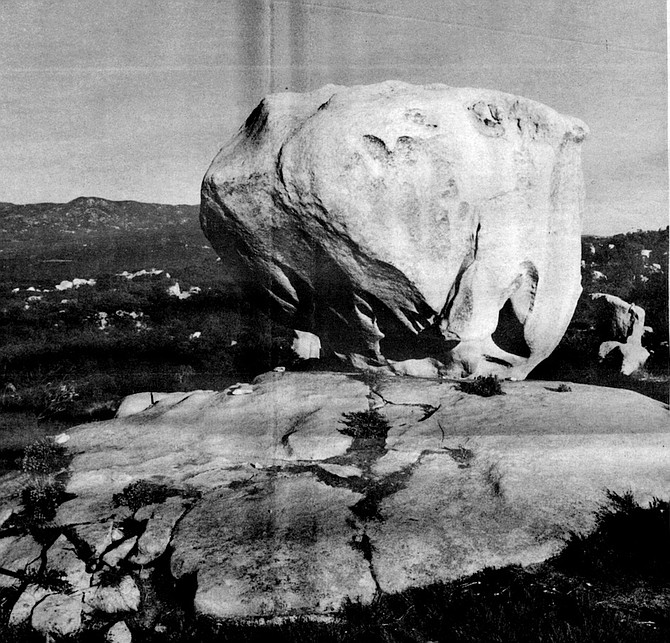
Just east of Jacumba, where Interstate 8 leads steeply down to the Colorado desert, tonalite is bared in fantastic pyramids that are one of the eeriest sights in the county.
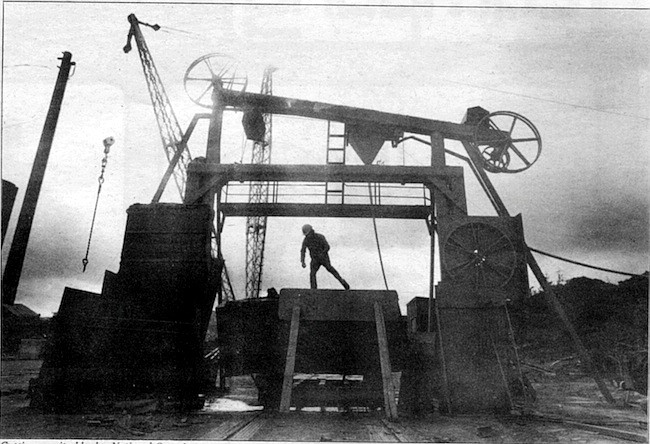
The boulders rattle down a chute into the deep black mouth of the crusher. Inside the machine, two heavy steel plates come together repeatedly with force beyond imagination. Whoomp! Whoomp! Whoomp! And 150 million years of history is broken into softball-size pieces and comes out on a conveyor belt on the other side, moving toward yet another crusher in this quarry just west of Cowles Mountain on Mission Gorge Road.
Granite blocks, National Quarries. Nearly all of northern and eastern San Diego County is made up of granite rock; it formed in vast pools underground while the island volcanoes were still smoking to the west.
Gordon Gastil peers into the mouth of the crusher, checks the rock coming out the far side, smiles faintly. The rock is andesite, he says, a hard gray volcanic stone that once constituted a chain of islands where San Diego now stands. Gastil, a professor of geology at San Diego State University, has spent more than twenty years studying the evolution of the San Diego area and the forces that gave it its current shape, and he makes such pronouncements with conviction. “Old rock like this makes up the basement rock of the region all the way from Guerrero Negro in Baja California up to Orange County" he adds.
Gastil and I pass south of Rancho Bernardo, crossing again the dried-up delta of the river that flowed here 50 million years ago. That river flowed for ten million years.
Ancient volcanoes lie buried beneath the beaches of San Diego. Mountain ranges that once rose across the county have disappeared. A river that flowed here from Sonora, Mexico dried up long ago, when tapirs the size of terriers wandered the county and crocodiles wallowed in marshy lagoons. The history that Gastil studies is a history beyond people, a history of primitive planetary energies and great, unfathomable time.
Tonalite formations along Interstate 8
And yet much of it is vitally important to humans. The water that flowed across underground reservoirs of still-cooling granite 100 million years ago contained the gold that prospectors found in the Laguna Mountains, leading to the founding of the town of Julian and, subsequently, the Cleveland National Forest. A gigantic plate of the earth’s crust that began to move away from mainland Mexico 60 million years ago is still moving, causing the earthquakes that make skyscrapers sway and send bookcases crashing to the floor. One of the biggest questions in San Diego’s future is fundamentally a geological one: how much oil lies off our coast? And remnants of the volcanic islands that once stood in San Diego’s place are crushed and used to make asphalt — tough, long-lasting asphalt — that covers the county’s roads.
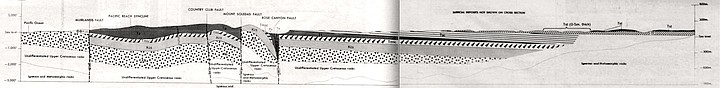
Geology of the La Jolla Quadrangle. The volcanic islands that once were San Diego spewed lava and ash for 60 million years. And then the volcanoes fell silent and the earth’s crust began to rise.
We had arrived unannounced at the quarry in the early morning. The management, suspicious at first and not eager for publicity because of ongoing conflicts with surrounding housing developments, at last agreed to let us in (on condition that they and the quarry remain unnamed). And almost immediately we came to a great gray wall of stone — the original quarry ledge, now abandoned — rising out of a pool of murky green water. In that wall you can still read the record of the awesome volcanoes that built the ancient islands.
Pride of the West mine, Julian, 1900. The water that flowed across underground reservoirs of granite 100 million years ago contained the gold that prospectors found in the Laguna Mountains, leading to the founding of Julian.
Seams in the gray mass represent fractures through which molten rock rose toward the surface, then cooled. In places, smaller rocks embedded in the gray stone testify to material that was hurled high into the air and rained down on the surrounding region. “It blew out in pieces the size of your fist down to dust,” Gastil comments. “The fine layering you can see over there indicates ash falls. The rock here probably goes down for a kilometer or two; it’s very thick. There’s no place in the county where these old rocks are so undisturbed.”
Polishing granite, National Quarries. The surface of dense granite like that quarried by National can be polished to a degree of level smoothness unmatched by any other material on earth.
But there are other places where the old rock is exposed. Although much of it now lies buried beneath coastal sediments, it juts up in Spring Valley and at Rancho Bernardo. Hikers and horseback riders pass by huge weathered boulders of it in the middle of Penasquitos Canyon County Park. Otay Mountain is almost solid andesite thrown out by these old volcanoes.
The andesite is not the oldest rock in the county; that distinction belongs to rough gray marble, half a billion years old, that has been found near the mouth of Palm Canyon in Anza-Borrego Desert State Park. At one time the marble was the floor of some shallow, temperate sea, but little more is known about it. And even less is known about what happened here for the next 350 million years after the marble began to form. But 150 million years ago islands rose out of the water where the houses and shopping centers of San Diego now stand. On their shores grew reeds and redwood trees, and coral reefs rose from the shallows nearby. The islands extended in an arc from Mexico to Alaska along the coast of what is now North America; but most of North America lay underwater then, and the islands may have stood far out to sea, like the volcanic islands of Japan today. The earth was a different planet then, a planet we would not recognize. But the core of those ancient islands survived to form the oldest solid evidence of San Diego County to stand above the sea.
The quarry’s foreman leads Gastil and me over to a pile of the finished, crushed andesite that is twenty feet high. A thin stream of the gravel-size pebbles pours steadily down from a conveyor belt high overhead. We scoop fistfuls of the stones out of the pile and examine them; these bits of old island have a dry, smooth feel, but edges sharp enough to cut flesh. “The rock breaks angularly, and it’s very hard,” Gastil points out. “That’s why it’s good for asphalt.”
There is a simple serenity in contemplating rocks. In a world plagued by deadlines, constant changes, frenzied rushing from one place to another, rocks endure. For all practical purposes they are permanent, and their feel is reassuring and infinitely diverse: the fine, smooth grain of marble; granite’s gritty, solid texture; the razor-sharp edges of obsidian.
Examining rocks, you can read the forces of heat and pressure that formed them, and along with that their astoundingly great age. So there is time in geology, all the time in the world. In that sense it is a peaceful science.
In a few minutes Gastil and I get back into my station wagon and head up Interstate 15 toward Poway. The andesite quarry was interesting and we could have stayed longer; but we have plans to spend the rest of the day investigating the county’s geology, and we have 150 million years of history to discuss.
Gastil is a man of medium height with a big, open face. His black hair tends to lie on his head in an unruly sort of way, giving him the look of an absent-minded professor. But that image is contradicted by his sharp, topaz-blue eyes. He is fifty-six, but I discovered he can make his way easily up steep hillsides that left me huffing with the effort. His knowledge of local geology is encyclopedic, and if you ask him a question, he will sometimes give you a ten-minute answer, closing his eyes and spouting the information as though he were reading it on some inner screen. On one of our several forays around the county we ran into a young man who was fossil-hunting in a remote desert canyon. More to make conversation than anything else, the young man asked us if we knew where to find the best fossil beds in the area. Gastil responded with a five-minute soliloquy on the three or four top sites, complete with the fossil and rock types to be found there. Amazed, the young man finally observed, “Looks like I asked the right person.”
As we speed up the freeway toward Poway, Gastil tells me that the chain of volcanic islands that once was San Diego spewed lava and ash over a wide region for 60 million years. And then, for reasons that geologists can only guess at, the volcanoes fell silent and the earth’s crust began to rise. Gradually the coast of North America emerged from the sea, and with it San Diego County. The new coast lay only a mile or so inland from where it does today, and Gastil thinks it was steep, at least in places. In Baja California canyons he has found fossilized oysters from this era that lived near the shore, and a short distance westward in those same canyons lie marine sediments that could only have been deposited in deep water. “So the water must have dropped off rapidly, sort of like it does along Highway 1 in central California today,” he concludes.
Along this ancient coast reptiles fifteen feet tall walked on their hind legs. They swam in coastal lagoons, too, breathed through nostrils on the tops of their heads, and scooped up plants from the shallows with flat bills that a duck would envy. The climate was tropical — not unlike that of, say, Costa Rica — and the land was covered with lush forests of palms, redwoods, and giant ferns forty feet high. Lobsters and crabs scuttled across the ocean floor, and above them swam mosasaurs, thirty-foot-long oceanic reptiles with dagger-like teeth that make a modern white shark look like a tuna.
The fossilized bones of duck-billed dinosaurs (along with other creatures and petrified wood from this era) have been found embedded in rock near El Rosario, some 230 miles south of the U.S. border on Baja’s Pacific coast. But although the same hard orange-and-green rock can be seen on Point Loma, in the coastal cliffs of Pacific Beach, and in Carlsbad, only a single fragment of dinosaur bone had been found here until last December, when Brad Riney noticed the tip of a bone protruding from the earth just north of Palomar Airport in Carlsbad. Riney, a paleontological consultant, was working for a local construction firm that is building an industrial park, and he had been following bulldozers around the construction site every day for two months without finding a single fossil. “It does get kind of noisy out there,” said Riney, who wears earplugs on the job. “But right after quitting time — it was December 22 — I had just come back from another part of the site when I saw the bone. One of the bulldozer’s last scrapes had clipped it on the top and popped it up. It was smooth, shiny, coffee-brown — totally different from the surrounding rock. I knew right away what it was, but I had no idea how big it was.” Riney excavated the bone that same night (there is every reason to make haste in such cases to avoid having a fossil become lost, destroyed, or stolen). It turned out to be almost three feet long. The bone was later identified as the thigh bone of a duck-billed dinosaur, and it is the largest dinosaur bone ever discovered in Southern California.
Gastil and I turn eastward off Interstate 15 onto Pomerado Road, passing through a forest of eucalyptus and then out onto rolling, chaparral-covered hills. Signs everywhere advertise new housing developments: Whispering Woods, Loire Valley. After a few miles we come to a place where the road cuts a deep, narrow channel through a hillside, and Gastil tells me to stop. The thirty-foot banks that rise on either side of us are made up of tan earth full of rounded stones that are purple, green, and red. Gastil explains that this deposit is called the Poway conglomerate, and it was the delta of a river some 50 million years ago. Long after the duckbills died out, silt and stones carried by this river buried most of the coastline on which they had walked. Its delta can now be found from Encanto to Rancho Bernardo and eastward to the San Vicente Reservoir.
Gastil, who was born in San Diego in 1928, first investigated the Poway conglomerate as a boy growing up on property his parents owned on Fulmar Street, near what is now College Grove Shopping Center. His father grew avocados and raised frying chickens, but Gastil was more interested in the wide variety of rocks and fossils he could find in the canyons near home. He studied geology at San Diego State and UC Berkeley, and, after obtaining his doctorate at Berkeley in 1954, worked for a company exploring for iron in Labrador and Quebec.
In 1959 Gastil returned to San Diego and soon began teaching geology at SDSU. Not long after that he got it into his head to put together a geologic map of Baja California. At the time little was known about the types of rocks that existed on the Baja peninsula; to a geologist it was like a cake waiting to be savored. Of course there was a reason why Baja had not been mapped: most of it is a harsh, sparsely populated land, and parts of it were considered virtually uncrossable wilderness. But that didn't deter Gastil. With the aid of a National Science Foundation grant and a few graduate students, he and his fellow professor at State, Edwin Allison, began the project in 1963. They spent much of the next eight years mapping the northern half of the peninsula. “We traveled mostly by vehicle, but we used mules in the large areas that roads just don't get into, like the southern part of the Sierra San Pedro Martir.” Gastil recalls. “Several places along the gulf are (also) difficult to get to, and you can't use mules because there's so little fresh water. So we did those areas by boat, using Bahia de Los Angeles as a base.”
Gastil claims he never had any close calls while scrambling across the ' ravines and loose mountain slopes of Baja, but one of the students who worked with him was not so lucky. One afternoon during the summer of 1966, Charles Anthenill and another student were hiking back to a camp near Mission Santa Gertrudis (about sixty miles southeast of Guerrero Negro) when they split up to pursue separate routes. But Anthenill never returned to camp. That night the rest of the party stayed up late, honking car horns and waving flashlights, hoping to elicit some response from the missing student. But the only answer was an impassive silence.
“The next morning we went back in there, and soon had all kinds of ranchers on horseback and airplanes trying to locate him. . . . He was found at the bottom of a gulch, with some of the things from his pack scattered along the slope up above. He had died instantly, apparently. He was only a short distance from where he had separated from his partner, and must have been killed shortly after they separated. But the slope wasn't so steep that you'd think he actually plunged down it. You could walk down that slope, so why he ended up sprawled in the bushes at the bottom never really did add up. The only way he could have slipped and fallen down there would be if he started running down the bank. You can imagine maybe he saw a mountain lion or something, and started to run. . . . ’’
Gastil's geologic map of northern Baja was published in 1971. It is a jigsaw of bright colors (each color represents a different rock type), and it is the kind of map you can imagine a prospector poring over some night in front of a campfire, with coyotes yelping nearby. Gastil still visits Baja frequently — friends say his aging Chevy pickup is in more or less constant need of repair from the jolting it takes on Baja’s back roads — but he has a civic-minded streak in him, too. He has served on the county's air pollution control board, and he was chairman of a committee appointed by former mayor Pete Wilson to study the hazards of drilling for offshore oil. Gastil even ran for Congress in the 1975 Democratic primary (he finished second to King Golden, who in turn lost to incumbent Republican Bob Wilson). “I had this theory that in order for democracy to work, everybody had to be willing to run for office," he explains. “Otherwise, only the scoundrels would get elected. . . . When I lost [the primary election], I intended to rest for a while and then run again. But the further away from it I got, the more I thought, ‘Well, I've done my share.’ " He laughs — a short, dry laugh full of amusement and irony.
We get out of the car to look at the stones laid down by the ancient river in the banks on Pomerado Road. Some are the size of baseballs, and Gastil picks up a few and examines them thoughtfully. Many of these stones were thrown out by volcanoes in Sonora, and all of them were carried here 50 million years ago by the river, he says, some 175 miles across rolling hills to the coast. San Diego County was part of mainland Mexico then — it would be another 40 million years before the Baja peninsula would begin to tear away from the mainland, swinging the county northward into its current position and creating the Gulf of California — but the earth's climate had changed again and San Diego was no longer the steamy tropical forest it was when duck-billed dinosaurs swam in the coastal marshes. Clays and salts embedded in this river delta are similar to those found only in relatively dry, hot parts of the western United States today, and two local geologists at San Diego State have interpreted this to mean that the ancient river ran through a country warmer and with about twice as much rainfall as modern San Diego. In other words, 50 million years ago the county looked a little like Sacramento, California. Microscopic pollen grains that have survived in the delta sediments reveal that mangrove and nut-palm trees grew along the river’s banks. Primitive dog-faced primates lived in them, and crocodiles lay on the damp ground below. Rabbits and squirrel-like rodents scampered through the underbrush and tried to avoid the big boa snakes that hunted them. Flies and other insects were profuse.
The river delta from this area is the foundation rock for many communities and buildings in San Diego — Grossmont College, San Carlos, parts of La Mesa, Santee, Clairemont, and almost all of Scripps Ranch, for example — and it is exposed in massive beds in the Hazard and Conrock quarries in Mission Valley. These companies use the volcanic stones embedded in the river sediments for asphalt and concrete aggregate, valuing the rocks for the same reasons the Indians who fashioned them into primitive knives and choppers did: for their hardness and ability to hold a sharp, angular edge.
We drive back to Interstate 15 and head north again, passing the dark andesite of Rancho Bernardo and the granite bedrock of Escondido. The rocks that make up the county can be compared to a cake, but it is a cake in which the forces of the last 150 million years have lifted, split apart, worn down, and sometimes buried the original layers until they are jumbled together almost unrecognizably. Patches of andesite now lie next to outcrops of granite that didn’t exist when the andesite first formed; and next to that might be a layer of coastal sandstone that didn't appear for another 50 million years. To a geologist, landscapes are mysteries waiting to be solved, but as Gastil confirms with his dry laugh, it takes a lot of investigation to solve them.
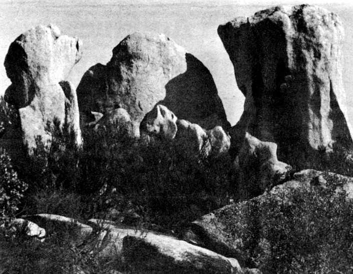
North of Escondido we turn west on Deer Springs Road, climb through a low gap in a ridge, and drop down into the San Marcos Valley. Scattered across the hillsides around us are huge granite boulders, and after winding our way several miles up Twin Oaks Valley Road we come to National Quarries, where every day granite is blasted out of the green hills in twenty-ton blocks. Nearly all of northern and eastern San Diego County is made up of granite rock; it formed in vast pools underground while the island volcanoes were still smoking to the west. But different pools of the rock had different chemical compositions, resulting in several kinds of granite: the pink granodiorite of El Capitan Mountain; the pretty white tonalite of Campo and McCain Valley; the dark gray gabbro of Cuyamaca Peak. All of these rocks formed somewhere between three and nine miles below the earth’s surface, but as the county rose 100 million years ago they were steadily pushed upward and the rocks that had once pressed down on them eroded away. Now the granite mass within the county lies open to the sky from Vista and Mount Palomar to El Cajon and Jacumba. In places it has become covered with soil washed down from the surrounding peaks, but just east of Jacumba, where Interstate 8 leads steeply down to the Colorado desert, tonalite is bared in fantastic pyramids that are one of the eeriest sights in the county. These mountains are made of boulders that look as if they have somehow been stacked on top of each other, but the boulders were once a solid mass of tonalite that has been weathered into smaller chunks by countless years of heat and rain. The rain also combines with minerals in the rock, covering the white tonalite with a thin brown stain known as desert varnish; and high winds scour the peaks clean of most soil, leaving them to stand starkly under the desert sun.
As granite cools underground, the elements in it combine to form tiny mineral crystals, giving the rock its familiar speckled appearance. In tonalite, for instance, white crystals of quartz are interspersed with crystals of black hornblende and sparkling mica. But some elements don’t combine readily with others and tend to remain dissolved in the last hot liquid portions of the granite. Silver is among these elements, as are lead, uranium, and gold. Groundwater seeping down from the surface picks up these dissolved metals and carries them to the outer edges of the cooling granite, where they crystallize and harden. Which is why, Gastil explains, when prospectors first found gold near Julian in the 1870s, it was almost always in veins just outside large masses of granitic rocks.
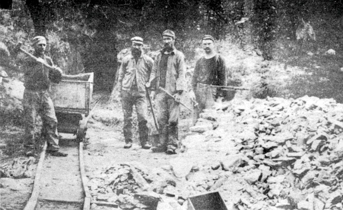
Amos Weed didn't know much about the origins of the county’s gold, and if someone had told him, he probably wouldn't have been impressed. Weed was a cousin of Ephraim Morse, a San Diego merchant and entrepreneur, and became manager and foreman at Morse's Oriflamme Mine near Julian in 1875. By then the area was teeming with prospectors who had been attracted by the discovery of gold-bearing quartz ledges at the George Washington and Stonewall mines in 1870. The town of Julian was first laid out and constructed that same year by miners — one of the more obvious instances in which the county's modem history has been directly influenced by its ancient geological one.
Weed was a competent but somewhat gloomy foreman who had a knack for turning plain words into eloquent statements, as can be seen in the letters he wrote to Morse. On September 12, 1875 Weed moved into a cabin near the Oriflamme Mine, and, like most prospectors, he had arrived with glowing hopes of striking it rich. But at first he had difficulty locating any worthwhile gold at all. Weed described what faint traces of the stuff he did find as “floury," “fine," and “more like yellow paint than gold." But by November his luck seemed to be changing. He wrote Morse:
For god sake what kind of a tempest have you got in San Diego! It is blowing the top of the hills off here it commenced yesterday morning and blowing in alternate gusts from every quarter. I can’t make a fire in the stove it blows the fire clear acrost the flore. The wind is still increasing. . . .I have been at work every day on the claim I could, opening the Ledge in different places. I find gold everywhere on the ledge. . . .
The nights are very cold now. ... I wish I had something to read anything I would not care what.
Weed
Quarrying the rock was tough work done with picks and shovels in a darkened tunnel lit by candles. Often the miners had to pack the rough ore out on their backs to the surface. After a few days of labor such as this, many of the miners were of a mind to do a little celebrating, even if they hadn't found pay dirt. They had come to Julian seeking gold, but they often settled for liquids fortified rather liberally with alcohol. The town gained a reputation for its ten-cent shots of whiskey, and by the 1890s there were no fewer than twenty-four saloons in Julian where a gentleman could quench his thirst. It wasn't unusual for the citizens to empty pistols at each other over card games, politics, and other important matters, but it was rare for someone actually to get hit with a bullet. Far more dangerous was the work in the mines, where cave-ins were a constant threat and a fall down a slanting 150-foot shaft could leave you laid up for months waiting for your bones to mend.
In December of 1875 Weed wrote to Morse:
You say there is some misunderstanding with your folks in regard to my wages, when I come up I had an understanding with you for forty dollars per month to take charge of the property here and keep the same from going to waste but I did not agree to doe anything more, but when I came up Mr. Pierce wanted me to prospect the mine which I did immediately and since you concluded to get out some rock I have been at work faithful every day getting out as much as I could.
Now for the amount of work I have been doing I think I ought to have $2.00 per day and board Sundays excepted, as when any more men comes to work they will expect me to cook for them besides. Should this not meet with the views of your people, you will please let me know immediately so I can commence work elsewhere.
Yours Truly
Amos Weed
Weed stayed on, but Morse was spending a small fortune on the Oriflamme Mine and by January of 1876 he began making plans to sell it. Weed offered his (unsolicited) opinion on the possible sale, and closed with some customarily bleak comments about his current situation:
I should not be in a hurry about presing a sale for this claim if I was in your place until I found out something more about it as I think by holding on you may make in the end. . . .
We had a snow storm the other day but it is nearly all gone it is getting very cold now night before last my water bucket frose over sitting by the stove, in the morning the ice was 1/2 inch thick I don’t know when I have suffered so much with the cold I shall go down (into the mine] again armed with another blanket.
This is all at present
Yours Truly
Amos Weed
But Morse's mine, like most of those in the Julian area, was flat-out disappointing. A few produced richly: the Stonewall Mine yielded more than two million dollars in gold from 1870 to the turn of the century: the Golden Chariot, $700,000; the Helvetia, $450,000. In contrast, Morse got about $2500 worth out of the Oriflamme, and in April, 1876 instructed Weed to send him an inventory of food on hand in preparation for putting the mine up for sale. Weed replied faithfully:
Grub on hand 125 lbs. flour; 125 lbs. Potatoes; about 40 lbs. Corned Beef; 5 gal. keg syrup; 25 lbs. Beans; 15 lbs. sugar; 4 papers Soda; 2 Bot. 1 Mustard 1 pepper; 2 lbs. raisins; 3 lbs. rice; 1 lbs. Tea; 2 qts. Vinegar; 3 lbs. Butter; 6 cans condensed Milk. . . .
P.S. My eyes will be turned towards the top of the hill from this on for some one to relieve me.
Yours Weed
The following year Morse found someone to lease the mine for six months, and the year after that he finally unloaded it to a group of investors for a bargain price.
Vast quantities of wood were needed to fuel the boilers of Julian’s mines; the boilers were used to run hoists, water pumps, and the heavy stamp mills which crushed raw ore for processing. The boilers of the Stonewall Mine alone consumed twelve cords of wood every twenty-four hours during the mine’s heyday, and that is a lot of felled trees. But besides cutting down trees, the new settlers in the mountains destroyed the forest by inadvertently setting wildfires that sometimes burned out of control for weeks at a time. People in far-off San Diego began to voice concerns over the watershed of the San Diego River, an important source of water for the city, and in 1908 much of the land surrounding Julian was incorporated into the newly established Cleveland National Forest.
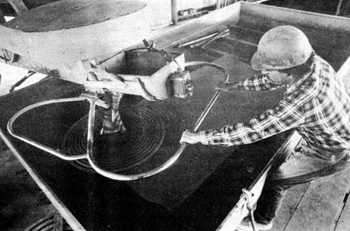
There is undoubtedly still gold in the hills near Julian, and a few mines there continue to be worked. But these days there is a bigger business in quarrying the rock from which the gold once came: granite. Several quarries near Vista and San Marcos cut and sell granite blocks for jetties and rip-rap; National Quarries near San Marcos, however, is the only quarry in the county that sells a high grade of granite for use in precision industrial processes. The surface of dense granite like that quarried by National can be polished to a degree of level smoothness unmatched by any other material on earth — more level than steel plates, for instance — with variations of less than forty millionths of an inch. A piece of notebook paper is 3000 millionths of an inch thick, so the variations on the granite don’t amount to much. Most of these granite plates produced locally are shipped to the Silicon Valley south of San Francisco, where they are used in the manufacture of computer wafers and to measure things such as screws and circuit boards very precisely. “Criminy,” says Mike Johnson, “it’s unbelievable what they’ll do with a block of granite.”
Johnson, whose family owns National, explains to Gastil and me that people are constantly asking him to produce more of these high-grade “surface plates” for industry. But it is difficult, time-consuming work, and so instead Johnson and his workers at the San Marcos quarry spend most of their time producing simpler stones: gravestones. The rock is blasted out of the ground with a small amount of black powder, hoisted onto trucks with a crane, and transported to the quarry’s wire saws. The saws, 1800-foot-long cables that circulate continuously, draw an abrasive solution through grooves in the granite and can cut through an eight-foot-thick block in about half a day. ‘ ‘The longer the wires are, the longer they last," explains Johnson. "At this length we can saw for about a week with one wire."
After being cut, the three-inch-thick, four-by-eight-foot blocks are ground, polished, and buffed to a shiny finish. Then they are cut to gravestone size. Most of the markers are designed to lie flat on the ground, a fact Johnson laments. He would like to make more upright monuments for people's last resting places, he says, but "people in California like the flat grass markers so they can mow right over the top of them. They're not as pretty; they're just done for speed."
We pause in front of rows of markers that are arranged on end, like books on a shelf. In one of them I can see my face reflected as if in a dark gray mirror, and over my shoulder is Gastil. Johnson remarks, "We’ve always called the granite Imperial Blue. It’s actually almost black, but that’s what we’ve always called it. Either way it's got a great finish. Nothing really affects it at all. It won’t blister or chip; water won’t affect it, alkali won't affect it. . . . You won't find anyone that won't tell you that's a dandy grave marker."
Gold was not the only precious thing concealed in the county's granite millions of years ago; gems were tucked away in it, too. Garnet, beryl, topaz, and a great quantity of tourmaline — all have been found here in hardened seams in the granite called pegmatite dikes. First discovered in the 1890s, the gemstones did not spark a rush like the one for gold primarily because tourmaline, although highly prized by connoisseurs, was a relatively little-known stone. Most of the county’s tourmaline was mined in the first ten years of the Twentieth Century from gem-rich hills near Mesa Grande, and was shipped to brokerage houses in New York. It is said these brokerage firms were controlled by Chinese who sold most of the pink, green, and sometimes blue stones to China's ruling elite. Between 1902 and 1910 tourmaline worth more than half a million dollars was taken from the Himalaya Mine alone, and the total amount produced by the county’s mines eventually exceeded two million dollars. But the raw tourmaline crystals were difficult to mine, and the pockets of the gem that were discovered never seemed to last for long. In 1911 a revolt in China ended the reign of the Manchu Dynasty and cooled the market for tourmaline as well. Large-scale gem mining in San Diego gradually fell off, although in 1919 a seventeen-carat blue topaz was found in the hills north of Warner Springs and cut into a striking pear-shaped gem that was displayed at the Smithsonian Institution.
As Gastil and I return to Interstate 15 and drive south through Escondido, he tells me that pegmatite dikes typically form in large granite masses like the one that underlies northern and eastern San Diego County. As the hot granite cools, cracks form in it which then fill with the last residue of molten rock. Just as in the formation of gold, this final liquid is rich with unusual elements, "things that don't fit into other minerals," as Gastil puts it, including the silicate brew that gives rise to most gemstones. The gem crystals begin to grow in hollow spaces in the dike as the rock hardens around them, building on each other as they come out of solution. If the hollow space stays open long enough and "these things are allowed to just grow quietly in there for thousands of years, that's when you get these enormous crystals," Gastil explains.
A red-tailed hawk floats gracefully over the freeway as we pass south of Rancho Bernardo, crossing again the dried-up delta of the river that flowed here 50 million years ago. That river flowed for ten million years, Gastil says — 2000 times as long as recorded human history — but eventually it, too, vanished from the earth. He thinks the river's course was disrupted by mountain ranges and deep basins that began to appear south and east of the county about 40 million years ago, as great plates of the earth's crust began to shift into their current positions.
The plates are still moving, driven by "spreading ridges" on the ocean floor where molten rock is pouring out and causing the earth’s crust to grow at a rate of a few centimeters each year. The new crust nudges the plates that cover the rest of the planet's surface, forcing them to slide past each other and sometimes up on top of each other; in a few cases they collide head on. While Gastil and I speed past Miramar Naval Air Station, he explains with a laugh that "one thing plate tectonics | as the science of crustal movement is called) has never explained is why the oceans are spreading apart and shoving the continents around and hanging them into each other. But people generally think that this has been going on for a long time. One theory is that it’s part of a cycle that takes half a billion years, maybe longer. The spreading eventually drives all the continents together, and then they split up and push off in the other direction until they all run into each other again/’ He shrugs.
Most of North America is on a single crustal plate, but a large sliver of California (including San Diego and the Baja peninsula) is on another plate that includes the Pacific Ocean floor. The main division between the two is the notorious San Andreas fault, which in Southern California runs down the eastern side of the Salton Sea and into the Gulf of California. The movement of the Pacific plate northwestward from the North American plate is what has created the gulf, a body of water that has been steadily widening since it first appeared as a narrow inlet about ten million years ago. But these plates do not glide past each other silently, like ships; they shriek and groan as layers of rock more than a hundred miles thick are driven past each other a few inches at a time. Each groan signals an earthquake, and they can be frighteningly powerful. Just after 11:00 p.m. on the night of February 23, 1892, the ground in San Diego began to swell and roll as an earthquake wave passed through it. Although there was no equipment to measure earthquakes then, some local scientists say that, based on the published accounts, this quake could well have been the strongest to hit the city in recorded history. “The streets were filled with an excited crowd," reported the San Diego Union. “Tall buildings swayed dangerously. . . . Persons on the street felt the quake plainly and were obliged to brace themselves in order to maintain their equilibrium.” In Campo the heaving ground caused an adobe blacksmith shop to split apart and collapse. Remarkably, no one was killed.
Buildings in San Diego are now fortified in various ways to withstand the stress put on them by earthquakes. A building of up to four or five stories is constructed with extra-rigid walls to withstand the shaking during a quake, but skyscrapers are protected by a different method. Their steel skeletons are made with flexible joints that will give during violent shaking, because the pressure on them becomes so great they might otherwise snap. The flexible joints allow a twenty-story' skyscraper to sway one or two feet from side to side during an earthquake, which may not seem like much. But just ask anyone who was in the Cuyamaca Club on the afternoon of April 8, 1968, how much two feet is. That’s when a powerful earthquake generated in the Imperial Valley hit San Diego, causing the club, located on the twenty-third floor of what is now the Crocker Bank Building at Second and Broadway, to sway violently from side to side. A Union reporter who was in the club during the quake said people froze for several minutes, eyeing each other nervously as they held on to counters and pillars for support. The Union also noted that the quake downed power wires and knocked merchandise off shelves in stores all over the county. People driving on the city’s freeways were alarmed when the roadbed beneath them began shaking unpredictably; they were undoubtedly even more alarmed when they looked up to see massive concrete bridges trembling in front of them. The quake, the strongest to reach San Diego in recent years, was measured at 6.5 on the Richter scale (Alaska’s devastating earthquake of 1964 was 8.5).
Although they are much smaller than the San Andreas fault (and over the last fifty years have generated much smaller earthquakes), there are dozens of faults in San Diego, too. According to Phil Kern, an SDSU geologist who has been mapping local faults in recent years, the metropolitan area is literally “honeycombed” with them from the international border to Del Mar. The largest is the Rose Canyon fault, and its location is fairly precisely known. It runs northward along the bottom of San Diego Bay, slants beneath the intersection of Cedar and State streets downtown, crosses Interstate 5 east of Lindbergh Field, and heads up to Tecolote Park in Claire-mont. There, one afternoon not long ago. Kern showed me the fault’s most visible trace. Pulling out a few weeds that grow in an embankment just beyond the left-center-field fence of the Tecolote Pony League field, he pointed to a crack that angles through the rock underneath. “Faults are breaks in the plates, and they're generally deep-seated,” Kern told me. “Presumably, this one goes hundreds of kilometers down through the earth’s crust and into part of the mantle.” From Tecolote Park the Rose Canyon fault runs northward along the east side of Interstate 5, bends toward the coast along Ardath Road, and heads out to sea beneath the La Jolla Beach and Tennis Club.
Over the last several million years the movement of the Rose Canyon fault has altered the face of San Diego in a major way. The flat coastal area west of the fault has been creeping northward, causing La Jolla to bulge out into the sea and creating La Jolla Cove. “La Jolla is getting closer to L.A.,“ Kern said laughingly, “and downtown San Diego is getting closer to east La Jolla.” At the same time, pressure along the fault has created Mount Soledad. Mount Soledad and Kearny Mesa were once part of the same flat surface, Kern explained, and lay in the ocean shallows. The ocean retreated, and the mountain was subsequently fractured and pushed up some 600 feet above the mesa along the Rose Canyon fault. “So if not for the fault. Mount Soledad would be part of Kearny Mesa,” he said, which would certainly be a distasteful prospect to the hundreds of wealthy San Diegans whose half-million-dollar homes ring the mountain's upper slopes.
Most of San Diego, from the current beaches to Tierrasanta, was covered by the ocean at one time or another during the last few million years as the coastline fluctuated back and forth. The land was at a lower elevation than it is today; whales swam in downtown Hillcrest, and brightly colored sea slugs made their way slowly across Clairemont. Dolphins, walruses, and thirty-foot-long sea cows dove in Chula Vista. But about five million years ago the county began to rise, Gastil says, for reasons that are not clear but are probably related to the relentless creeping of the Pacific plate. Eventually the sandy sediments that had been shallow ocean bottom became a series of mesas and terraces that stood above the sea. To the east the Laguna Mountains were pushed up from an elevation of about 1500 feet to their current elevation of more than 6000 feet. The streams rushing off these newly risen mountains began to cut into the soft coastal mesas and eventually created the maze of canyons and valleys that make up most of metropolitan San Diego today. “So all these canyons have been cut in relatively recent times,” Gastil says as we head down Murphy Canyon Road toward Mission Valley. In the canyon walls around us erosion has revealed the old ocean beds. Some are 150 feet thick — a million years or more of silt and sand filtering down to the ocean bottom layer after fine layer.
In a half hour more, Gastil and I are pulling into a parking lot on the seaward side of Point Loma. To the west the surface of the ocean is a calm metallic-blue plane stretching to the horizon, but at the foot of the cliffs below us white water roars and surges on a sandstone ledge. At low tide this ledge becomes a rocky expanse riddled with tide pools. Gastil says that in the long term the coast of California is still emerging from the sea, and if the trend continues, this sandstone ledge will eventually rise just as the mesas of Mission Hills and Kearny Mesa did long ago. People will build expensive ocean-front houses on it, if people are still around then, and someone will build a road along it called either Ocean Cliffs Avenue or Via Del Mar, depending on what the prevailing language of the region is then.
The future could bring a powerful earthquake, too. Kern says the Rose Canyon fault may be locked where it bends westward around Mount Soledad, and if it is, pressure could be mounting along it. “When you get a fault locked, it just defers the time when the next earthquake comes,” Kern explains. “Typically, what happens is that the stresses build up and then release in one big quake.” If that happens (and Kern says the probabilities are low). La Jolla will inch a little closer to Los Angeles, while Pacific Beach residents might get a chance to upgrade their zip code to 92037.
In the meantime, erosion will continue to break down the mesas and widen the canyons of San Diego until eventually the mesa tops will disappear altogether. The city will become a region of more gentle, rolling hills then, according to Gastil, and the shopping centers of Mission Valley will be no more than a bad memory buried beneath soft river sediments. I ask how long that will take, and Gastil grins. Maybe a million years, maybe more.
Long before that happens the city will have to deal with another one of its geological legacies: offshore oil. The stuff has been collecting out there for perhaps three million years as microscopic sea creatures called diatoms died and drifted to the ocean floor. Eventually they were buried and warmed by hot rock beneath them, and were transformed chemically into pools of hydrocarbons. The oil reservoirs offshore of San Diego exist in rocks near sea level down to depths of several thousand feet — at least, that is what the oil companies are hoping. Gastil says test wells have never turned up any oil. “Before they drilled it, I'd say (the area) was moderately promising (for finding oil], but now that they've drilled it. I’d say it isn’t promising.” But the rock formations are the right type and age for oil (they are similar to those found on the Arabian Peninsula), and Gastil concedes that “maybe the oil companies know something that isn't public information."
The leasing of offshore tracts here has been postponed indefinitely largely due to opposition from the Navy. But the concern over what oil-drilling could do to San Diego's beaches and tourist industry, not to mention its ocean view, continues. In a recent round of bickering, Republican Assemblywoman Sunny Mojonnier, whose 75th Assembly District includes the beach area from Imperial Beach to Leucadia, was castigated by opponents of the drilling for voting against a bill that will request the federal government to delete San Diego tracts from offshore leasing until 1986 (the bill passed both houses of the state legislature last month). Mojonnier insists she is against offshore oil drilling, but says she voted against the bill because it was rushed to a vote ahead of her own similar bill. Drilling opponents claim such reasoning is “petty," and say that Mojonnier may in fact have reversed her stand on offshore oil after being pressured by Governor George Deukmejian.
A few days after Mojonnier’s vote came to light I called Chris Heiserman, an administrative aide for Mojonnier. He insisted Mojonnier is firmly opposed to offshore drilling, and as evidence pointed to the bill she was writing herself. “Part of the reason Sunny voted against the other bill was political, but I don't think it was all that petty," he said, explaining that as a first-term assemblywoman Mojonnier is trying to build a reputation for tackling issues that are important to her constituents.
I asked Heiserman if he has ever stopped to mull over the fact that the controversy his boss is involved in has been brought about by a chemical stew that has been collecting offshore for three million years. In that time the whole county has shifted fifty miles northward; species of animals have evolved and died out; the very ground on which Mojonnier's University City office stands has been the floor of an ancient sea. Somehow, I said, knowing all that makes the political machinations of the California state assembly seem kind of insignificant.
"Three million years," said Heiserman. “That’s several terms longer than Sunny has been in office." He paused for a moment. “No, that’s not something I would think about on a daily basis," he finally responded. “It wouldn’t help get the work around here done."
Here's something you might be interested in.
When dinosaurs roamed and volcanoes roared in San Diego
San Diego State's Gordon Gastil has studied the area's evolution for 20 years
When dinosaurs roamed and volcanoes roared in San Diego
San Diego State's Gordon Gastil has studied the area's evolution for 20 years
Just east of Jacumba, where Interstate 8 leads steeply down to the Colorado desert, tonalite is bared in fantastic pyramids that are one of the eeriest sights in the county.
The boulders rattle down a chute into the deep black mouth of the crusher. Inside the machine, two heavy steel plates come together repeatedly with force beyond imagination. Whoomp! Whoomp! Whoomp! And 150 million years of history is broken into softball-size pieces and comes out on a conveyor belt on the other side, moving toward yet another crusher in this quarry just west of Cowles Mountain on Mission Gorge Road.
Granite blocks, National Quarries. Nearly all of northern and eastern San Diego County is made up of granite rock; it formed in vast pools underground while the island volcanoes were still smoking to the west.
Gordon Gastil peers into the mouth of the crusher, checks the rock coming out the far side, smiles faintly. The rock is andesite, he says, a hard gray volcanic stone that once constituted a chain of islands where San Diego now stands. Gastil, a professor of geology at San Diego State University, has spent more than twenty years studying the evolution of the San Diego area and the forces that gave it its current shape, and he makes such pronouncements with conviction. “Old rock like this makes up the basement rock of the region all the way from Guerrero Negro in Baja California up to Orange County" he adds.
Gastil and I pass south of Rancho Bernardo, crossing again the dried-up delta of the river that flowed here 50 million years ago. That river flowed for ten million years.
Ancient volcanoes lie buried beneath the beaches of San Diego. Mountain ranges that once rose across the county have disappeared. A river that flowed here from Sonora, Mexico dried up long ago, when tapirs the size of terriers wandered the county and crocodiles wallowed in marshy lagoons. The history that Gastil studies is a history beyond people, a history of primitive planetary energies and great, unfathomable time.
Tonalite formations along Interstate 8
And yet much of it is vitally important to humans. The water that flowed across underground reservoirs of still-cooling granite 100 million years ago contained the gold that prospectors found in the Laguna Mountains, leading to the founding of the town of Julian and, subsequently, the Cleveland National Forest. A gigantic plate of the earth’s crust that began to move away from mainland Mexico 60 million years ago is still moving, causing the earthquakes that make skyscrapers sway and send bookcases crashing to the floor. One of the biggest questions in San Diego’s future is fundamentally a geological one: how much oil lies off our coast? And remnants of the volcanic islands that once stood in San Diego’s place are crushed and used to make asphalt — tough, long-lasting asphalt — that covers the county’s roads.
Geology of the La Jolla Quadrangle. The volcanic islands that once were San Diego spewed lava and ash for 60 million years. And then the volcanoes fell silent and the earth’s crust began to rise.
We had arrived unannounced at the quarry in the early morning. The management, suspicious at first and not eager for publicity because of ongoing conflicts with surrounding housing developments, at last agreed to let us in (on condition that they and the quarry remain unnamed). And almost immediately we came to a great gray wall of stone — the original quarry ledge, now abandoned — rising out of a pool of murky green water. In that wall you can still read the record of the awesome volcanoes that built the ancient islands.
Pride of the West mine, Julian, 1900. The water that flowed across underground reservoirs of granite 100 million years ago contained the gold that prospectors found in the Laguna Mountains, leading to the founding of Julian.
Seams in the gray mass represent fractures through which molten rock rose toward the surface, then cooled. In places, smaller rocks embedded in the gray stone testify to material that was hurled high into the air and rained down on the surrounding region. “It blew out in pieces the size of your fist down to dust,” Gastil comments. “The fine layering you can see over there indicates ash falls. The rock here probably goes down for a kilometer or two; it’s very thick. There’s no place in the county where these old rocks are so undisturbed.”
Polishing granite, National Quarries. The surface of dense granite like that quarried by National can be polished to a degree of level smoothness unmatched by any other material on earth.
But there are other places where the old rock is exposed. Although much of it now lies buried beneath coastal sediments, it juts up in Spring Valley and at Rancho Bernardo. Hikers and horseback riders pass by huge weathered boulders of it in the middle of Penasquitos Canyon County Park. Otay Mountain is almost solid andesite thrown out by these old volcanoes.
The andesite is not the oldest rock in the county; that distinction belongs to rough gray marble, half a billion years old, that has been found near the mouth of Palm Canyon in Anza-Borrego Desert State Park. At one time the marble was the floor of some shallow, temperate sea, but little more is known about it. And even less is known about what happened here for the next 350 million years after the marble began to form. But 150 million years ago islands rose out of the water where the houses and shopping centers of San Diego now stand. On their shores grew reeds and redwood trees, and coral reefs rose from the shallows nearby. The islands extended in an arc from Mexico to Alaska along the coast of what is now North America; but most of North America lay underwater then, and the islands may have stood far out to sea, like the volcanic islands of Japan today. The earth was a different planet then, a planet we would not recognize. But the core of those ancient islands survived to form the oldest solid evidence of San Diego County to stand above the sea.
The quarry’s foreman leads Gastil and me over to a pile of the finished, crushed andesite that is twenty feet high. A thin stream of the gravel-size pebbles pours steadily down from a conveyor belt high overhead. We scoop fistfuls of the stones out of the pile and examine them; these bits of old island have a dry, smooth feel, but edges sharp enough to cut flesh. “The rock breaks angularly, and it’s very hard,” Gastil points out. “That’s why it’s good for asphalt.”
There is a simple serenity in contemplating rocks. In a world plagued by deadlines, constant changes, frenzied rushing from one place to another, rocks endure. For all practical purposes they are permanent, and their feel is reassuring and infinitely diverse: the fine, smooth grain of marble; granite’s gritty, solid texture; the razor-sharp edges of obsidian.
Examining rocks, you can read the forces of heat and pressure that formed them, and along with that their astoundingly great age. So there is time in geology, all the time in the world. In that sense it is a peaceful science.
In a few minutes Gastil and I get back into my station wagon and head up Interstate 15 toward Poway. The andesite quarry was interesting and we could have stayed longer; but we have plans to spend the rest of the day investigating the county’s geology, and we have 150 million years of history to discuss.
Gastil is a man of medium height with a big, open face. His black hair tends to lie on his head in an unruly sort of way, giving him the look of an absent-minded professor. But that image is contradicted by his sharp, topaz-blue eyes. He is fifty-six, but I discovered he can make his way easily up steep hillsides that left me huffing with the effort. His knowledge of local geology is encyclopedic, and if you ask him a question, he will sometimes give you a ten-minute answer, closing his eyes and spouting the information as though he were reading it on some inner screen. On one of our several forays around the county we ran into a young man who was fossil-hunting in a remote desert canyon. More to make conversation than anything else, the young man asked us if we knew where to find the best fossil beds in the area. Gastil responded with a five-minute soliloquy on the three or four top sites, complete with the fossil and rock types to be found there. Amazed, the young man finally observed, “Looks like I asked the right person.”
As we speed up the freeway toward Poway, Gastil tells me that the chain of volcanic islands that once was San Diego spewed lava and ash over a wide region for 60 million years. And then, for reasons that geologists can only guess at, the volcanoes fell silent and the earth’s crust began to rise. Gradually the coast of North America emerged from the sea, and with it San Diego County. The new coast lay only a mile or so inland from where it does today, and Gastil thinks it was steep, at least in places. In Baja California canyons he has found fossilized oysters from this era that lived near the shore, and a short distance westward in those same canyons lie marine sediments that could only have been deposited in deep water. “So the water must have dropped off rapidly, sort of like it does along Highway 1 in central California today,” he concludes.
Along this ancient coast reptiles fifteen feet tall walked on their hind legs. They swam in coastal lagoons, too, breathed through nostrils on the tops of their heads, and scooped up plants from the shallows with flat bills that a duck would envy. The climate was tropical — not unlike that of, say, Costa Rica — and the land was covered with lush forests of palms, redwoods, and giant ferns forty feet high. Lobsters and crabs scuttled across the ocean floor, and above them swam mosasaurs, thirty-foot-long oceanic reptiles with dagger-like teeth that make a modern white shark look like a tuna.
The fossilized bones of duck-billed dinosaurs (along with other creatures and petrified wood from this era) have been found embedded in rock near El Rosario, some 230 miles south of the U.S. border on Baja’s Pacific coast. But although the same hard orange-and-green rock can be seen on Point Loma, in the coastal cliffs of Pacific Beach, and in Carlsbad, only a single fragment of dinosaur bone had been found here until last December, when Brad Riney noticed the tip of a bone protruding from the earth just north of Palomar Airport in Carlsbad. Riney, a paleontological consultant, was working for a local construction firm that is building an industrial park, and he had been following bulldozers around the construction site every day for two months without finding a single fossil. “It does get kind of noisy out there,” said Riney, who wears earplugs on the job. “But right after quitting time — it was December 22 — I had just come back from another part of the site when I saw the bone. One of the bulldozer’s last scrapes had clipped it on the top and popped it up. It was smooth, shiny, coffee-brown — totally different from the surrounding rock. I knew right away what it was, but I had no idea how big it was.” Riney excavated the bone that same night (there is every reason to make haste in such cases to avoid having a fossil become lost, destroyed, or stolen). It turned out to be almost three feet long. The bone was later identified as the thigh bone of a duck-billed dinosaur, and it is the largest dinosaur bone ever discovered in Southern California.
Gastil and I turn eastward off Interstate 15 onto Pomerado Road, passing through a forest of eucalyptus and then out onto rolling, chaparral-covered hills. Signs everywhere advertise new housing developments: Whispering Woods, Loire Valley. After a few miles we come to a place where the road cuts a deep, narrow channel through a hillside, and Gastil tells me to stop. The thirty-foot banks that rise on either side of us are made up of tan earth full of rounded stones that are purple, green, and red. Gastil explains that this deposit is called the Poway conglomerate, and it was the delta of a river some 50 million years ago. Long after the duckbills died out, silt and stones carried by this river buried most of the coastline on which they had walked. Its delta can now be found from Encanto to Rancho Bernardo and eastward to the San Vicente Reservoir.
Gastil, who was born in San Diego in 1928, first investigated the Poway conglomerate as a boy growing up on property his parents owned on Fulmar Street, near what is now College Grove Shopping Center. His father grew avocados and raised frying chickens, but Gastil was more interested in the wide variety of rocks and fossils he could find in the canyons near home. He studied geology at San Diego State and UC Berkeley, and, after obtaining his doctorate at Berkeley in 1954, worked for a company exploring for iron in Labrador and Quebec.
In 1959 Gastil returned to San Diego and soon began teaching geology at SDSU. Not long after that he got it into his head to put together a geologic map of Baja California. At the time little was known about the types of rocks that existed on the Baja peninsula; to a geologist it was like a cake waiting to be savored. Of course there was a reason why Baja had not been mapped: most of it is a harsh, sparsely populated land, and parts of it were considered virtually uncrossable wilderness. But that didn't deter Gastil. With the aid of a National Science Foundation grant and a few graduate students, he and his fellow professor at State, Edwin Allison, began the project in 1963. They spent much of the next eight years mapping the northern half of the peninsula. “We traveled mostly by vehicle, but we used mules in the large areas that roads just don't get into, like the southern part of the Sierra San Pedro Martir.” Gastil recalls. “Several places along the gulf are (also) difficult to get to, and you can't use mules because there's so little fresh water. So we did those areas by boat, using Bahia de Los Angeles as a base.”
Gastil claims he never had any close calls while scrambling across the ' ravines and loose mountain slopes of Baja, but one of the students who worked with him was not so lucky. One afternoon during the summer of 1966, Charles Anthenill and another student were hiking back to a camp near Mission Santa Gertrudis (about sixty miles southeast of Guerrero Negro) when they split up to pursue separate routes. But Anthenill never returned to camp. That night the rest of the party stayed up late, honking car horns and waving flashlights, hoping to elicit some response from the missing student. But the only answer was an impassive silence.
“The next morning we went back in there, and soon had all kinds of ranchers on horseback and airplanes trying to locate him. . . . He was found at the bottom of a gulch, with some of the things from his pack scattered along the slope up above. He had died instantly, apparently. He was only a short distance from where he had separated from his partner, and must have been killed shortly after they separated. But the slope wasn't so steep that you'd think he actually plunged down it. You could walk down that slope, so why he ended up sprawled in the bushes at the bottom never really did add up. The only way he could have slipped and fallen down there would be if he started running down the bank. You can imagine maybe he saw a mountain lion or something, and started to run. . . . ’’
Gastil's geologic map of northern Baja was published in 1971. It is a jigsaw of bright colors (each color represents a different rock type), and it is the kind of map you can imagine a prospector poring over some night in front of a campfire, with coyotes yelping nearby. Gastil still visits Baja frequently — friends say his aging Chevy pickup is in more or less constant need of repair from the jolting it takes on Baja’s back roads — but he has a civic-minded streak in him, too. He has served on the county's air pollution control board, and he was chairman of a committee appointed by former mayor Pete Wilson to study the hazards of drilling for offshore oil. Gastil even ran for Congress in the 1975 Democratic primary (he finished second to King Golden, who in turn lost to incumbent Republican Bob Wilson). “I had this theory that in order for democracy to work, everybody had to be willing to run for office," he explains. “Otherwise, only the scoundrels would get elected. . . . When I lost [the primary election], I intended to rest for a while and then run again. But the further away from it I got, the more I thought, ‘Well, I've done my share.’ " He laughs — a short, dry laugh full of amusement and irony.
We get out of the car to look at the stones laid down by the ancient river in the banks on Pomerado Road. Some are the size of baseballs, and Gastil picks up a few and examines them thoughtfully. Many of these stones were thrown out by volcanoes in Sonora, and all of them were carried here 50 million years ago by the river, he says, some 175 miles across rolling hills to the coast. San Diego County was part of mainland Mexico then — it would be another 40 million years before the Baja peninsula would begin to tear away from the mainland, swinging the county northward into its current position and creating the Gulf of California — but the earth's climate had changed again and San Diego was no longer the steamy tropical forest it was when duck-billed dinosaurs swam in the coastal marshes. Clays and salts embedded in this river delta are similar to those found only in relatively dry, hot parts of the western United States today, and two local geologists at San Diego State have interpreted this to mean that the ancient river ran through a country warmer and with about twice as much rainfall as modern San Diego. In other words, 50 million years ago the county looked a little like Sacramento, California. Microscopic pollen grains that have survived in the delta sediments reveal that mangrove and nut-palm trees grew along the river’s banks. Primitive dog-faced primates lived in them, and crocodiles lay on the damp ground below. Rabbits and squirrel-like rodents scampered through the underbrush and tried to avoid the big boa snakes that hunted them. Flies and other insects were profuse.
The river delta from this area is the foundation rock for many communities and buildings in San Diego — Grossmont College, San Carlos, parts of La Mesa, Santee, Clairemont, and almost all of Scripps Ranch, for example — and it is exposed in massive beds in the Hazard and Conrock quarries in Mission Valley. These companies use the volcanic stones embedded in the river sediments for asphalt and concrete aggregate, valuing the rocks for the same reasons the Indians who fashioned them into primitive knives and choppers did: for their hardness and ability to hold a sharp, angular edge.
We drive back to Interstate 15 and head north again, passing the dark andesite of Rancho Bernardo and the granite bedrock of Escondido. The rocks that make up the county can be compared to a cake, but it is a cake in which the forces of the last 150 million years have lifted, split apart, worn down, and sometimes buried the original layers until they are jumbled together almost unrecognizably. Patches of andesite now lie next to outcrops of granite that didn’t exist when the andesite first formed; and next to that might be a layer of coastal sandstone that didn't appear for another 50 million years. To a geologist, landscapes are mysteries waiting to be solved, but as Gastil confirms with his dry laugh, it takes a lot of investigation to solve them.
North of Escondido we turn west on Deer Springs Road, climb through a low gap in a ridge, and drop down into the San Marcos Valley. Scattered across the hillsides around us are huge granite boulders, and after winding our way several miles up Twin Oaks Valley Road we come to National Quarries, where every day granite is blasted out of the green hills in twenty-ton blocks. Nearly all of northern and eastern San Diego County is made up of granite rock; it formed in vast pools underground while the island volcanoes were still smoking to the west. But different pools of the rock had different chemical compositions, resulting in several kinds of granite: the pink granodiorite of El Capitan Mountain; the pretty white tonalite of Campo and McCain Valley; the dark gray gabbro of Cuyamaca Peak. All of these rocks formed somewhere between three and nine miles below the earth’s surface, but as the county rose 100 million years ago they were steadily pushed upward and the rocks that had once pressed down on them eroded away. Now the granite mass within the county lies open to the sky from Vista and Mount Palomar to El Cajon and Jacumba. In places it has become covered with soil washed down from the surrounding peaks, but just east of Jacumba, where Interstate 8 leads steeply down to the Colorado desert, tonalite is bared in fantastic pyramids that are one of the eeriest sights in the county. These mountains are made of boulders that look as if they have somehow been stacked on top of each other, but the boulders were once a solid mass of tonalite that has been weathered into smaller chunks by countless years of heat and rain. The rain also combines with minerals in the rock, covering the white tonalite with a thin brown stain known as desert varnish; and high winds scour the peaks clean of most soil, leaving them to stand starkly under the desert sun.
As granite cools underground, the elements in it combine to form tiny mineral crystals, giving the rock its familiar speckled appearance. In tonalite, for instance, white crystals of quartz are interspersed with crystals of black hornblende and sparkling mica. But some elements don’t combine readily with others and tend to remain dissolved in the last hot liquid portions of the granite. Silver is among these elements, as are lead, uranium, and gold. Groundwater seeping down from the surface picks up these dissolved metals and carries them to the outer edges of the cooling granite, where they crystallize and harden. Which is why, Gastil explains, when prospectors first found gold near Julian in the 1870s, it was almost always in veins just outside large masses of granitic rocks.
Amos Weed didn't know much about the origins of the county’s gold, and if someone had told him, he probably wouldn't have been impressed. Weed was a cousin of Ephraim Morse, a San Diego merchant and entrepreneur, and became manager and foreman at Morse's Oriflamme Mine near Julian in 1875. By then the area was teeming with prospectors who had been attracted by the discovery of gold-bearing quartz ledges at the George Washington and Stonewall mines in 1870. The town of Julian was first laid out and constructed that same year by miners — one of the more obvious instances in which the county's modem history has been directly influenced by its ancient geological one.
Weed was a competent but somewhat gloomy foreman who had a knack for turning plain words into eloquent statements, as can be seen in the letters he wrote to Morse. On September 12, 1875 Weed moved into a cabin near the Oriflamme Mine, and, like most prospectors, he had arrived with glowing hopes of striking it rich. But at first he had difficulty locating any worthwhile gold at all. Weed described what faint traces of the stuff he did find as “floury," “fine," and “more like yellow paint than gold." But by November his luck seemed to be changing. He wrote Morse:
For god sake what kind of a tempest have you got in San Diego! It is blowing the top of the hills off here it commenced yesterday morning and blowing in alternate gusts from every quarter. I can’t make a fire in the stove it blows the fire clear acrost the flore. The wind is still increasing. . . .I have been at work every day on the claim I could, opening the Ledge in different places. I find gold everywhere on the ledge. . . .
The nights are very cold now. ... I wish I had something to read anything I would not care what.
Weed
Quarrying the rock was tough work done with picks and shovels in a darkened tunnel lit by candles. Often the miners had to pack the rough ore out on their backs to the surface. After a few days of labor such as this, many of the miners were of a mind to do a little celebrating, even if they hadn't found pay dirt. They had come to Julian seeking gold, but they often settled for liquids fortified rather liberally with alcohol. The town gained a reputation for its ten-cent shots of whiskey, and by the 1890s there were no fewer than twenty-four saloons in Julian where a gentleman could quench his thirst. It wasn't unusual for the citizens to empty pistols at each other over card games, politics, and other important matters, but it was rare for someone actually to get hit with a bullet. Far more dangerous was the work in the mines, where cave-ins were a constant threat and a fall down a slanting 150-foot shaft could leave you laid up for months waiting for your bones to mend.
In December of 1875 Weed wrote to Morse:
You say there is some misunderstanding with your folks in regard to my wages, when I come up I had an understanding with you for forty dollars per month to take charge of the property here and keep the same from going to waste but I did not agree to doe anything more, but when I came up Mr. Pierce wanted me to prospect the mine which I did immediately and since you concluded to get out some rock I have been at work faithful every day getting out as much as I could.
Now for the amount of work I have been doing I think I ought to have $2.00 per day and board Sundays excepted, as when any more men comes to work they will expect me to cook for them besides. Should this not meet with the views of your people, you will please let me know immediately so I can commence work elsewhere.
Yours Truly
Amos Weed
Weed stayed on, but Morse was spending a small fortune on the Oriflamme Mine and by January of 1876 he began making plans to sell it. Weed offered his (unsolicited) opinion on the possible sale, and closed with some customarily bleak comments about his current situation:
I should not be in a hurry about presing a sale for this claim if I was in your place until I found out something more about it as I think by holding on you may make in the end. . . .
We had a snow storm the other day but it is nearly all gone it is getting very cold now night before last my water bucket frose over sitting by the stove, in the morning the ice was 1/2 inch thick I don’t know when I have suffered so much with the cold I shall go down (into the mine] again armed with another blanket.
This is all at present
Yours Truly
Amos Weed
But Morse's mine, like most of those in the Julian area, was flat-out disappointing. A few produced richly: the Stonewall Mine yielded more than two million dollars in gold from 1870 to the turn of the century: the Golden Chariot, $700,000; the Helvetia, $450,000. In contrast, Morse got about $2500 worth out of the Oriflamme, and in April, 1876 instructed Weed to send him an inventory of food on hand in preparation for putting the mine up for sale. Weed replied faithfully:
Grub on hand 125 lbs. flour; 125 lbs. Potatoes; about 40 lbs. Corned Beef; 5 gal. keg syrup; 25 lbs. Beans; 15 lbs. sugar; 4 papers Soda; 2 Bot. 1 Mustard 1 pepper; 2 lbs. raisins; 3 lbs. rice; 1 lbs. Tea; 2 qts. Vinegar; 3 lbs. Butter; 6 cans condensed Milk. . . .
P.S. My eyes will be turned towards the top of the hill from this on for some one to relieve me.
Yours Weed
The following year Morse found someone to lease the mine for six months, and the year after that he finally unloaded it to a group of investors for a bargain price.
Vast quantities of wood were needed to fuel the boilers of Julian’s mines; the boilers were used to run hoists, water pumps, and the heavy stamp mills which crushed raw ore for processing. The boilers of the Stonewall Mine alone consumed twelve cords of wood every twenty-four hours during the mine’s heyday, and that is a lot of felled trees. But besides cutting down trees, the new settlers in the mountains destroyed the forest by inadvertently setting wildfires that sometimes burned out of control for weeks at a time. People in far-off San Diego began to voice concerns over the watershed of the San Diego River, an important source of water for the city, and in 1908 much of the land surrounding Julian was incorporated into the newly established Cleveland National Forest.
There is undoubtedly still gold in the hills near Julian, and a few mines there continue to be worked. But these days there is a bigger business in quarrying the rock from which the gold once came: granite. Several quarries near Vista and San Marcos cut and sell granite blocks for jetties and rip-rap; National Quarries near San Marcos, however, is the only quarry in the county that sells a high grade of granite for use in precision industrial processes. The surface of dense granite like that quarried by National can be polished to a degree of level smoothness unmatched by any other material on earth — more level than steel plates, for instance — with variations of less than forty millionths of an inch. A piece of notebook paper is 3000 millionths of an inch thick, so the variations on the granite don’t amount to much. Most of these granite plates produced locally are shipped to the Silicon Valley south of San Francisco, where they are used in the manufacture of computer wafers and to measure things such as screws and circuit boards very precisely. “Criminy,” says Mike Johnson, “it’s unbelievable what they’ll do with a block of granite.”
Johnson, whose family owns National, explains to Gastil and me that people are constantly asking him to produce more of these high-grade “surface plates” for industry. But it is difficult, time-consuming work, and so instead Johnson and his workers at the San Marcos quarry spend most of their time producing simpler stones: gravestones. The rock is blasted out of the ground with a small amount of black powder, hoisted onto trucks with a crane, and transported to the quarry’s wire saws. The saws, 1800-foot-long cables that circulate continuously, draw an abrasive solution through grooves in the granite and can cut through an eight-foot-thick block in about half a day. ‘ ‘The longer the wires are, the longer they last," explains Johnson. "At this length we can saw for about a week with one wire."
After being cut, the three-inch-thick, four-by-eight-foot blocks are ground, polished, and buffed to a shiny finish. Then they are cut to gravestone size. Most of the markers are designed to lie flat on the ground, a fact Johnson laments. He would like to make more upright monuments for people's last resting places, he says, but "people in California like the flat grass markers so they can mow right over the top of them. They're not as pretty; they're just done for speed."
We pause in front of rows of markers that are arranged on end, like books on a shelf. In one of them I can see my face reflected as if in a dark gray mirror, and over my shoulder is Gastil. Johnson remarks, "We’ve always called the granite Imperial Blue. It’s actually almost black, but that’s what we’ve always called it. Either way it's got a great finish. Nothing really affects it at all. It won’t blister or chip; water won’t affect it, alkali won't affect it. . . . You won't find anyone that won't tell you that's a dandy grave marker."
Gold was not the only precious thing concealed in the county's granite millions of years ago; gems were tucked away in it, too. Garnet, beryl, topaz, and a great quantity of tourmaline — all have been found here in hardened seams in the granite called pegmatite dikes. First discovered in the 1890s, the gemstones did not spark a rush like the one for gold primarily because tourmaline, although highly prized by connoisseurs, was a relatively little-known stone. Most of the county’s tourmaline was mined in the first ten years of the Twentieth Century from gem-rich hills near Mesa Grande, and was shipped to brokerage houses in New York. It is said these brokerage firms were controlled by Chinese who sold most of the pink, green, and sometimes blue stones to China's ruling elite. Between 1902 and 1910 tourmaline worth more than half a million dollars was taken from the Himalaya Mine alone, and the total amount produced by the county’s mines eventually exceeded two million dollars. But the raw tourmaline crystals were difficult to mine, and the pockets of the gem that were discovered never seemed to last for long. In 1911 a revolt in China ended the reign of the Manchu Dynasty and cooled the market for tourmaline as well. Large-scale gem mining in San Diego gradually fell off, although in 1919 a seventeen-carat blue topaz was found in the hills north of Warner Springs and cut into a striking pear-shaped gem that was displayed at the Smithsonian Institution.
As Gastil and I return to Interstate 15 and drive south through Escondido, he tells me that pegmatite dikes typically form in large granite masses like the one that underlies northern and eastern San Diego County. As the hot granite cools, cracks form in it which then fill with the last residue of molten rock. Just as in the formation of gold, this final liquid is rich with unusual elements, "things that don't fit into other minerals," as Gastil puts it, including the silicate brew that gives rise to most gemstones. The gem crystals begin to grow in hollow spaces in the dike as the rock hardens around them, building on each other as they come out of solution. If the hollow space stays open long enough and "these things are allowed to just grow quietly in there for thousands of years, that's when you get these enormous crystals," Gastil explains.
A red-tailed hawk floats gracefully over the freeway as we pass south of Rancho Bernardo, crossing again the dried-up delta of the river that flowed here 50 million years ago. That river flowed for ten million years, Gastil says — 2000 times as long as recorded human history — but eventually it, too, vanished from the earth. He thinks the river's course was disrupted by mountain ranges and deep basins that began to appear south and east of the county about 40 million years ago, as great plates of the earth's crust began to shift into their current positions.
The plates are still moving, driven by "spreading ridges" on the ocean floor where molten rock is pouring out and causing the earth’s crust to grow at a rate of a few centimeters each year. The new crust nudges the plates that cover the rest of the planet's surface, forcing them to slide past each other and sometimes up on top of each other; in a few cases they collide head on. While Gastil and I speed past Miramar Naval Air Station, he explains with a laugh that "one thing plate tectonics | as the science of crustal movement is called) has never explained is why the oceans are spreading apart and shoving the continents around and hanging them into each other. But people generally think that this has been going on for a long time. One theory is that it’s part of a cycle that takes half a billion years, maybe longer. The spreading eventually drives all the continents together, and then they split up and push off in the other direction until they all run into each other again/’ He shrugs.
Most of North America is on a single crustal plate, but a large sliver of California (including San Diego and the Baja peninsula) is on another plate that includes the Pacific Ocean floor. The main division between the two is the notorious San Andreas fault, which in Southern California runs down the eastern side of the Salton Sea and into the Gulf of California. The movement of the Pacific plate northwestward from the North American plate is what has created the gulf, a body of water that has been steadily widening since it first appeared as a narrow inlet about ten million years ago. But these plates do not glide past each other silently, like ships; they shriek and groan as layers of rock more than a hundred miles thick are driven past each other a few inches at a time. Each groan signals an earthquake, and they can be frighteningly powerful. Just after 11:00 p.m. on the night of February 23, 1892, the ground in San Diego began to swell and roll as an earthquake wave passed through it. Although there was no equipment to measure earthquakes then, some local scientists say that, based on the published accounts, this quake could well have been the strongest to hit the city in recorded history. “The streets were filled with an excited crowd," reported the San Diego Union. “Tall buildings swayed dangerously. . . . Persons on the street felt the quake plainly and were obliged to brace themselves in order to maintain their equilibrium.” In Campo the heaving ground caused an adobe blacksmith shop to split apart and collapse. Remarkably, no one was killed.
Buildings in San Diego are now fortified in various ways to withstand the stress put on them by earthquakes. A building of up to four or five stories is constructed with extra-rigid walls to withstand the shaking during a quake, but skyscrapers are protected by a different method. Their steel skeletons are made with flexible joints that will give during violent shaking, because the pressure on them becomes so great they might otherwise snap. The flexible joints allow a twenty-story' skyscraper to sway one or two feet from side to side during an earthquake, which may not seem like much. But just ask anyone who was in the Cuyamaca Club on the afternoon of April 8, 1968, how much two feet is. That’s when a powerful earthquake generated in the Imperial Valley hit San Diego, causing the club, located on the twenty-third floor of what is now the Crocker Bank Building at Second and Broadway, to sway violently from side to side. A Union reporter who was in the club during the quake said people froze for several minutes, eyeing each other nervously as they held on to counters and pillars for support. The Union also noted that the quake downed power wires and knocked merchandise off shelves in stores all over the county. People driving on the city’s freeways were alarmed when the roadbed beneath them began shaking unpredictably; they were undoubtedly even more alarmed when they looked up to see massive concrete bridges trembling in front of them. The quake, the strongest to reach San Diego in recent years, was measured at 6.5 on the Richter scale (Alaska’s devastating earthquake of 1964 was 8.5).
Although they are much smaller than the San Andreas fault (and over the last fifty years have generated much smaller earthquakes), there are dozens of faults in San Diego, too. According to Phil Kern, an SDSU geologist who has been mapping local faults in recent years, the metropolitan area is literally “honeycombed” with them from the international border to Del Mar. The largest is the Rose Canyon fault, and its location is fairly precisely known. It runs northward along the bottom of San Diego Bay, slants beneath the intersection of Cedar and State streets downtown, crosses Interstate 5 east of Lindbergh Field, and heads up to Tecolote Park in Claire-mont. There, one afternoon not long ago. Kern showed me the fault’s most visible trace. Pulling out a few weeds that grow in an embankment just beyond the left-center-field fence of the Tecolote Pony League field, he pointed to a crack that angles through the rock underneath. “Faults are breaks in the plates, and they're generally deep-seated,” Kern told me. “Presumably, this one goes hundreds of kilometers down through the earth’s crust and into part of the mantle.” From Tecolote Park the Rose Canyon fault runs northward along the east side of Interstate 5, bends toward the coast along Ardath Road, and heads out to sea beneath the La Jolla Beach and Tennis Club.
Over the last several million years the movement of the Rose Canyon fault has altered the face of San Diego in a major way. The flat coastal area west of the fault has been creeping northward, causing La Jolla to bulge out into the sea and creating La Jolla Cove. “La Jolla is getting closer to L.A.,“ Kern said laughingly, “and downtown San Diego is getting closer to east La Jolla.” At the same time, pressure along the fault has created Mount Soledad. Mount Soledad and Kearny Mesa were once part of the same flat surface, Kern explained, and lay in the ocean shallows. The ocean retreated, and the mountain was subsequently fractured and pushed up some 600 feet above the mesa along the Rose Canyon fault. “So if not for the fault. Mount Soledad would be part of Kearny Mesa,” he said, which would certainly be a distasteful prospect to the hundreds of wealthy San Diegans whose half-million-dollar homes ring the mountain's upper slopes.
Most of San Diego, from the current beaches to Tierrasanta, was covered by the ocean at one time or another during the last few million years as the coastline fluctuated back and forth. The land was at a lower elevation than it is today; whales swam in downtown Hillcrest, and brightly colored sea slugs made their way slowly across Clairemont. Dolphins, walruses, and thirty-foot-long sea cows dove in Chula Vista. But about five million years ago the county began to rise, Gastil says, for reasons that are not clear but are probably related to the relentless creeping of the Pacific plate. Eventually the sandy sediments that had been shallow ocean bottom became a series of mesas and terraces that stood above the sea. To the east the Laguna Mountains were pushed up from an elevation of about 1500 feet to their current elevation of more than 6000 feet. The streams rushing off these newly risen mountains began to cut into the soft coastal mesas and eventually created the maze of canyons and valleys that make up most of metropolitan San Diego today. “So all these canyons have been cut in relatively recent times,” Gastil says as we head down Murphy Canyon Road toward Mission Valley. In the canyon walls around us erosion has revealed the old ocean beds. Some are 150 feet thick — a million years or more of silt and sand filtering down to the ocean bottom layer after fine layer.
In a half hour more, Gastil and I are pulling into a parking lot on the seaward side of Point Loma. To the west the surface of the ocean is a calm metallic-blue plane stretching to the horizon, but at the foot of the cliffs below us white water roars and surges on a sandstone ledge. At low tide this ledge becomes a rocky expanse riddled with tide pools. Gastil says that in the long term the coast of California is still emerging from the sea, and if the trend continues, this sandstone ledge will eventually rise just as the mesas of Mission Hills and Kearny Mesa did long ago. People will build expensive ocean-front houses on it, if people are still around then, and someone will build a road along it called either Ocean Cliffs Avenue or Via Del Mar, depending on what the prevailing language of the region is then.
The future could bring a powerful earthquake, too. Kern says the Rose Canyon fault may be locked where it bends westward around Mount Soledad, and if it is, pressure could be mounting along it. “When you get a fault locked, it just defers the time when the next earthquake comes,” Kern explains. “Typically, what happens is that the stresses build up and then release in one big quake.” If that happens (and Kern says the probabilities are low). La Jolla will inch a little closer to Los Angeles, while Pacific Beach residents might get a chance to upgrade their zip code to 92037.
In the meantime, erosion will continue to break down the mesas and widen the canyons of San Diego until eventually the mesa tops will disappear altogether. The city will become a region of more gentle, rolling hills then, according to Gastil, and the shopping centers of Mission Valley will be no more than a bad memory buried beneath soft river sediments. I ask how long that will take, and Gastil grins. Maybe a million years, maybe more.
Long before that happens the city will have to deal with another one of its geological legacies: offshore oil. The stuff has been collecting out there for perhaps three million years as microscopic sea creatures called diatoms died and drifted to the ocean floor. Eventually they were buried and warmed by hot rock beneath them, and were transformed chemically into pools of hydrocarbons. The oil reservoirs offshore of San Diego exist in rocks near sea level down to depths of several thousand feet — at least, that is what the oil companies are hoping. Gastil says test wells have never turned up any oil. “Before they drilled it, I'd say (the area) was moderately promising (for finding oil], but now that they've drilled it. I’d say it isn’t promising.” But the rock formations are the right type and age for oil (they are similar to those found on the Arabian Peninsula), and Gastil concedes that “maybe the oil companies know something that isn't public information."
The leasing of offshore tracts here has been postponed indefinitely largely due to opposition from the Navy. But the concern over what oil-drilling could do to San Diego's beaches and tourist industry, not to mention its ocean view, continues. In a recent round of bickering, Republican Assemblywoman Sunny Mojonnier, whose 75th Assembly District includes the beach area from Imperial Beach to Leucadia, was castigated by opponents of the drilling for voting against a bill that will request the federal government to delete San Diego tracts from offshore leasing until 1986 (the bill passed both houses of the state legislature last month). Mojonnier insists she is against offshore oil drilling, but says she voted against the bill because it was rushed to a vote ahead of her own similar bill. Drilling opponents claim such reasoning is “petty," and say that Mojonnier may in fact have reversed her stand on offshore oil after being pressured by Governor George Deukmejian.
A few days after Mojonnier’s vote came to light I called Chris Heiserman, an administrative aide for Mojonnier. He insisted Mojonnier is firmly opposed to offshore drilling, and as evidence pointed to the bill she was writing herself. “Part of the reason Sunny voted against the other bill was political, but I don't think it was all that petty," he said, explaining that as a first-term assemblywoman Mojonnier is trying to build a reputation for tackling issues that are important to her constituents.
I asked Heiserman if he has ever stopped to mull over the fact that the controversy his boss is involved in has been brought about by a chemical stew that has been collecting offshore for three million years. In that time the whole county has shifted fifty miles northward; species of animals have evolved and died out; the very ground on which Mojonnier's University City office stands has been the floor of an ancient sea. Somehow, I said, knowing all that makes the political machinations of the California state assembly seem kind of insignificant.
"Three million years," said Heiserman. “That’s several terms longer than Sunny has been in office." He paused for a moment. “No, that’s not something I would think about on a daily basis," he finally responded. “It wouldn’t help get the work around here done."
Comments