Here's something you might be interested in.
Ask a Hipster — Advice you didn't know you needed
Big Screen — Movie commentary
Blurt — Music's inside track
Booze News — San Diego spirits
Classical Music — Immortal beauty
Classifieds — Free and easy
Close to Home — What it’s like on the street where you live
Cover Stories — Front-page features
Drinks All Around — Bartenders' drink recipes
Excerpts — Literary and spiritual excerpts
Feast! — Food & drink reviews
Feature Stories — Local news & stories
Fishing Report — What’s getting hooked from ship and shore
From the Archives — Spotlight on the past
Golden Dreams — Talk of the town
The Gonzo Report — Making the musical scene, or at least reporting from it
Letters — Our inbox
Movies@Home — Local movie buffs share favorites
Movie Reviews — Our critics' picks and pans
Musician Interviews — Up close with local artists
Neighborhood News from Stringers — Hyperlocal news
News Ticker — News & politics
Obermeyer — San Diego politics illustrated
Outdoors — Weekly changes in flora and fauna
Overheard in San Diego — Eavesdropping illustrated
Poetry — The old and the new
Reader Travel — Travel section built by travelers
Reading — The hunt for intellectuals
Roam-O-Rama — SoCal's best hiking/biking trails
San Diego Beer — Inside San Diego suds
SD on the QT — Almost factual news
Sheep and Goats — Places of worship
Special Issues — The best of
Street Style — San Diego streets have style
Surf Diego — Real stories from those braving the waves
Theater — On stage in San Diego this week
Tin Fork — Silver spoon alternative
Under the Radar — Matt Potter's undercover work
Unforgettable — Long-ago San Diego
Unreal Estate — San Diego's priciest pads
Your Week — Daily event picks
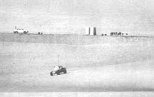
Rangers vs. the buggies in the Algodones Dunes
Who owns the desert?
“Some of these off-road-vehicle people claim that they don 't do any damage to the desert. They say, 'We just leave tracks.'"
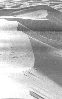
The wind picks up; here and there sand drifts across the blacktop like wisps of cloud. On either side of the highway the dunes extend to the horizon, tan, impassive giants with sparse scrub clinging to their sides. The plants are nearly all some shade of pastel — sun-bleached blue, pale dusty green — and look much too fragile to survive the withering heat of the sun. Yet there they are, swaying stiffly in the gusts of wind, a symbol of moisture and life somewhere beneath the mounds of sand.
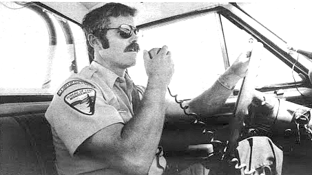
Dave Krouskop: "People out here have gone pretty much anywhere they pleased and done anything they wanted to do.’’
We are driving — Dave Krouskop and I — through the Algodones Dunes, one of the more unusual features of the southernmost of California's two deserts, the Colorado. Krouskop is a desert ranger out of the Bureau of Land Management’s field office in El Centro; his sturdy features are dominated by a bushy brown moustache. As he steers his jeep down the highway he scans the landscape on all sides. Summer has arrived, and with the temperature hovering around ninety degrees Fahrenheit (it is ten in the morning) the dunes are relatively deserted. A few dune buggies can be seen racing across the sand to the south, but this is a far cry, Krouskop explains, from the thousands of people who were here over the recent Memorial Day weekend.
“Actually, that isn't such an unusual speed out here.”
Like almost every other place, the California desert is getting crowded. The BLM’s information shows that more than sixteen million people live within 200 miles of some part of it, and this figure is expected to reach twenty million within a few years. About fifteen years ago this population boom began to cause bitter disputes among various groups who visited or lived in the desert. Environmentalists complained that the landscape was being torn up by motorcycles, dune buggies, trucks, and jeeps. The drivers of the vehicles complained that it wasn't fair to close certain areas to them in order to appease a few environmentalists. Meanwhile mining companies were petitioning for permission to excavate minerals and precious metals; wildlife biologists spoke of endangered species; utilities wanted rights of way for power lines and energy resource exploration. For years the BLM had administered its 473 million acres nationwide, including 12.5 million acres in the California desert, more or less passively. But in that time the public consciousness had changed. Now people were demanding that the BLM do more with its land than simply own it.
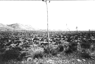
Davies Valley. On all sides of us is a wide plain covered with creosote, cholla, salt bush, and other shrubs.
Out of disputes like those over the desert grew the Federal Land Policy and Management Act, which directed the BLM to come up with a comprehensive multiple-use plan for its land holdings. It is the type of law that gains a minimum amount of public attention when it is passed and has a maximum impact on peoples’ lives for years to come. Officially the Congress gave the BLM fifteen years to ready its plan, but because the disputes in California’s desert had grown particularly critical. the Act created the special California Desert Conservation Area (CDCA), and gave the BLM just four years to recommend which areas within it were to be mined, which to be developed, which to be utilized for motorized recreation, and which to be preserved in their natural state.
"ORV enthusiasts still have unrestricted access to eighty-two percent of the dunes.”
That was in 1976; now there is only one year left, and the pressure on the BLM is mounting.
Krouskop turns off the highway onto a narrow blacktop road and drives to the top of a large dune. Below us a man and woman in a dune buggy maneuver slowly through a valley of sand. For miles in every direction, as far as one can see across the shimmering plain, the major landholder is the BLM. There are exactly 377 separate tracts of Bureau-owned land in the Desert Conservation Area, one-eighth of California's total land. One of Krouskop’s duties as ranger is to protect these tracts in their present condition, until their final use is determined by Congress.
But in the five years he has been a ranger the BLM has successfully prosecuted only one violator, and that was a man who had illegally built a house in the Jacumba Mountains. As he tells me this, Krouskop, who is generally rather serious, smiles thinly. “Traditionally, people out here have gone pretty much anywhere they pleased and done anything they wanted to do,’’ he says. “They’ve felt nobody’s going to bother them — and they’re right. For the last twenty or thirty years, nobody has.”
Twenty million years ago the climate of most of California’s desert was tropical. Rain fell heavily in the summer months, and the land was a network of rivers and freshwater lakes. Giant tree ferns grew abundantly, and primitive mammals roamed the area, including mastodons, rhinoceros, and the small three-toed horse Mesohippus. Hawks soared over the canyons, and in the ground the ancestors of rodents burrowed and raised their young. But the earth began to change as volcanoes erupted and huge plates of the earth’s crust shifted and ground into each other. Rocked by earthquakes, ancient Southern California's plains sank, forming an oval-shaped basin over 200 miles long.

At the same time the Peninsular ranges, including the Laguna Mountains, were pushed up, and thus cut off the flow of moisture-laden air from the coast. The winds still came incessantly from the west, but now they were burning and dry. Gradually the lakes and rivers began to disappear. The ferns and other plants died, and the mammals moved or suffered the same fate — all except the rodents, who learned to live without drinking. The soil that once supported life grew dry and coarse, and the winds picked it up and swirled it across the newly created basin, piling it up in huge mounds near the mountains on the eastern side. These mounds — 400 feet deep in some places — are still growing, and have come to be known as the Algodones Dunes.
As far as the BLM is concerned, the dunes fall into Dave Krouskop’s “patrol sector,” a tract bounded roughly by the dunes themselves on the north and west, the Colorado River on the east, and on the south by the international border with Mexico. Within this area of more than two million acres the BLM is responsible for about half the land; Krouskop is the Bureau’s only agent who visits any of it regularly. Krouskop has been a desert ranger since 1973. when the desert ranger program was first developed. Now thirty-eight years old. he has a bachelor’s degree in outdoor recreation and management from Colorado State University at Boulder, and worked for the National Park Service in.Texas before going to work for the BLM in El Centro. The ranger program first began, he tells me, in order to insure that the BLM's new regulations in certain areas of the desert were carried out. But the rangers had no authority to issue citations or make arrests, and they were often simply ignored. In 1977 new legislation empowered the rangers to make arrests, but still withheld from them the power to issue citations. “So now it’s kind of an all-or-nothing situation,” Krouskop shrugs. “But you don’t want to make an arrest if you can possibly avoid it; it creates a bad image.” In the two years since the rangers have had arrest authority, not a single arrest has been made.
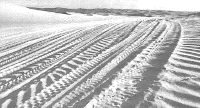
Krouskop laments the rangers’ ineffectiveness in policing BLM land, but claims that his job consists of more than just enforcing regulations. He says he looks for hazards (such as abandoned mines or live artillery shells left over from training maneuvers during World War II), gives emergency medical attention to injured drivers and hikers, searches for lost dogs, kids, and adults. His mode of transportation is a late-model jeep that he drives as much as 250 miles a day. It is equipped with two cameras, a shovel, a mirror and compass, two dozen flares, five gallons of water, smoke bombs, a fire extinguisher, oxygen, medical supplies, a winch, a tow strap, a jack, chains, a tire pump, binoculars, field guides for birds and mammals, maps, brochures, and a billy club — not to mention his thermos of coffee, two-way radio, and the tricolored (lashing lights on the roof of the cab, “Just basically what I need,” he says, “and not much more.” Nosing his jeep back onto Highway 78, Krouskop explains that nearly all of the visitors to the Algodones Dunes are offroad vehicle enthusiasts. The big crowds come from September to April, since the temperatures then are more tolerable — and not just for people. In the full heat of summer, or around 120 degrees Fahrenheit, the air-cooled engines that power most of the ORVs can’t cool themselves fast enough; they blow up. As we head eastward toward Glamis, Krouskop points to the north and south sides of the highway. The north side, an area closed to vehicles, is covered with low scrub, but the southern side, where vehicles are free to travel anywhere, is virtually bare. “Some of these off-road-vehicle people claim that they don 't do any damage to the desert,” he says. “They say, 'We just leave tracks; the first wind will cover them up.’ I always use the contrast between these two areas to show them that they do make a lasting effect.”
For their part, the off-road-vehicle people complain that the BLM is locking up the desert. In particular, they oppose the possibility that some areas may be designated “wilderness,” a special distinction under the Federal Land Policy and Management Act which would close an area permanently to vehicular travel, mining, and anything else that might significantly alter the pristine quality of the landscape. From 1978 to 1979 the BLM spent a full twelve months in an effort to identify any lands they control which might qualify for designation as wilderness. Two such areas have been identified in the dunes, and they have been at least temporarily closed to vehicles. “But they [the ORV enthusiasts] still have unrestricted access to eighty-two percent of the dunes,” Krouskop points out.
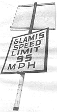
Vehicle travel in potential wilderness areas is generally restricted to existing major roads because, by law, the BLM must maintain these areas in their current state until their final use is determined by Congress. One of the results of this approach is that Krouskop, as a visible representative of the federal government, from time to time encounters hostile vehicle operators who resent being told where and how fast to drive, and generally think the BLM is trying to lay down a set of screwy regulations. As we pass into Glamis — a place that, with two buildings (one unoccupied), a small graveyard, and no electricity, bears a remarkable resemblance to its symbol on maps of the state, a small, hollow circle — he points to a sign that bears some of the antigovernment sentiment:
- Welcome to Glamis
- Speed Limit 95 m.p.h.
“Actually, that isn't such an unusual speed out here,” Krouskop observes, turning left onto a wide, gravelly county road. We head north, skirting the eastern edge of the dunes. “One evening a few weeks ago a guy on a Harley tried to take a turn in the road near Gekko Campground at about ninety. He didn’t make it, of course. He flew about 150 feet before he landed. I came by a little later and saw a group of people down off to the side of the road. I shined my light down there, and someone yelled up, 'You better come down here.’ When I got there the guy was lying face down in the sand. His face just right in the sand. I turned him over and gave him some oxygen, and after a while he started breathing on his own. Eventually we hauled him out and took him to the hospital, but as far as I know he never regained consciousness.”
The unpaved road stretches on and on and on. To our right rises the jagged blue ridge of the Chocolate Mountains; to our left is one of the two areas of the dunes that have been closed to vehicles (species of rare plants were discovered there). Krouskop has been peering into the scrub at the side of the road for some time, and now suddenly slows when he espies the end boundary of the closed area. Swinging off the main road we set out on a spine-jarring course toward a high ridge of the dunes about half a mile away. Lizards flee to cover at our approach. Whole plants disappear under the jeep’s hood and are ground into the sand by our tires. As we pass over a given patch of ground we leave wide tracks behind showing where we have been; the impressions are sharp and clearly visible. “The desert is a vast world, an oceanic world,” wrote Edward Abbey in Desert Solitaire, “as deep in its way and complex and various as the sea. ” In a few months our tracks here will probably disappear in the constant shifting of wind and sand, but elsewhere in the desert they would remain for thirty, forty, perhaps fifty years or more, preserved by the arid air and lack of rain, like a boat wake set in cement.
A man I spoke to in San Diego, a man whose sentiment runs toward preserving the environment, warned me at the outset, “Don’t make this out to be a war between ORV people and conservationists; the issues are much more complex than that.” In this he was absolutely right. In question is the whole attitude of man toward his environment. Nevertheless, even this man admitted that the conflict between ORV enthusiasts and conservationists is one of the “high profile” issues. And it is clear that this conflict and the questions it almost immediately raises — restricted or unrestricted access to desert areas, preservation or exploitation — are on the minds of nearly everyone who visits or lives in the desert. A few months ago I made a trip to the Fish Creek Mountains, a massive granite ridge that rises some 2500 feet out of the desert plain in Anza Borrego State Park. My companion and I drove for more than an hour up a dusty wash, to a place where the only sounds were the wind and the high, eerie twittering of white-throated swifts that periodically made forays from their cliffsidc nests fifty feet above us. We had been there only a few minutes when a low hum told us of the approach of another vehicle. Soon a dune buggy appeared carrying a family of four, who parked not thirty feet away, got out, and began talking loudly about the "environmentalists” who wanted to close large portions of the desert to vehicles. “I stay on the roads. I obey the regulations,” the father, a burly man covered with a fine layer of dust, told his son, “because I don’t want to give them any ammunition for their cause.” After a pause he added, ”’Course, we believe the only way you can see the desert is in a vehicle of some sort. You can’t hike to most of these areas because there’s no water.” Fifteen minutes later they all got back into the dune buggy and disappeared down the wash, leaving us to forever wonder if they had noticed the airborne swifts.
The split between conservationists and ORV people was dramatically demonstrated at a public hearing the BLM held at the SDG&E auditorium in downtown San Diego last December. The meeting marked the end of the preliminary inventory of all areas which would be studied for potential wilderness designation, and the BLM was soliciting comments that might pertain to specific areas. More than one hundred people showed up — the largest crowd at any such public hearing in the state, according to the BLM’s records. Presiding over the gathering was a judge from the Department of the Interior, who was flanked by two BLM officials. Below the dais sat a court reporter wearing glasses and a nondescript gray suit, repeating the proceedings rapidly and quietly into the microphone of a portable tape recorder.
From the beginning the battle lines were clearly drawn. The opposing groups were characterized by their dress as much as anything else: the conservationists wore plaid flannel shirts and jeans; the ORV people, who included several car and motorcycle clubs, wore brightly colored nylon jackets or T-shirts with car insignias on them; a third group, made up principally of elderly men who described themselves as “admitted rock-hounds,” wore sport coats, slacks, and string ties.
The most hotly disputed item of the evening was the question of what constituted a wilderness area and how such a designation would affect public access to that area. Frank Norris of the Sierra Club was the first to speak, and he urged that wilderness be given a high priority in the BLM’s overall plan. After that he named some thirty areas that he felt deserved particular attention. Several rock-hounds spoke next, including Clarence Ritter of Chula Vista, who charged that wilderness designation would essentially prevent children, senior citizens, and many others from visiting an area, since such people cannot generally hike very far (a wilderness area must have a minimum of 5000 acres). This was particularly true in the desert, Ritter noted, where “one cannot travel far without vehicular help.” Next, several ORV enthusiasts argued emotionally that the BLM’s definition of a road had been designed to limit vehicle access to the greatest possible extent. In particular, Richard Ramage of San Diego voiced suspicion about the BLM’s trend of closing more and more areas to vehicles. “Where will it stop?” he wondered, while the court reporter repeated his remarks into the microphone. After four hours of such comments, the judge from the Department of the Interior reiterated that the purpose of the hearing had been to gather information on specific areas, and, while most of the discussion had not addressed that concern, it would be filed and duly considered. Then he asked the BLM officials if they had any comments on the testimony. The BLM officials said no, they didn’t, and at a little after 11:00 p.m. everyone went home, wondering, perhaps, how government officials could always be so maddeningly noncommittal on subjects that were of such vital importance.
Several months later I contacted Frank Norris, a man whose intense dark eyes are made to look even darker and more intense by his shock of black hair and full beard. At twenty-eight, he is the president of a Sierra Club subcommittee on the desert, a group organized to monitor the progress of the BLM’s desert plan and to lobby for those decisions the Sierra Club feels are important. Their overall viewpoint is conservationist, and they have come to represent what their opponents, who sport bumper stickers such as Sierra Club: Go Hike To Hell, describe as knee-jerk environmentalism. I asked Norris about some of the questions raised at the hearing. He disagreed strongly with the general view that desert land should be kept accessible to the greatest number of people possible, and therefore vehicles, too. “What they’re saying is that their interest in not wanting to hike is more important than preserving the ecosystem,” he said simply.
Norris did say that parts of the desert should be reserved for off-road-vehicle use, and that some mining operations should continue. “I’m not a mining advocate, but I can see that certain areas may contain elements that are in the national interest to exploit,” he said. “But it takes an intermediary like the BLM for a confirmed ORVer and a conservationist to talk to each other. We think the ORV people are short-sighted. They seem to think God created the desert for man to go out in his vehicles in. When we go out to the desert, we see a lot of beauty, a lot of permanence, the ecosystem, the being of the desert. We’re concerned about what the desert will look like in one hundred years.”
Norris said he feels the BLM has done a good job providing information to the public and involving people in the data-gathering process. But he smiled when I mentioned the morass of regulations that surround public participation. “You definitely have to be into this whole process to know when to say what, and to whom, ” he commented. “But the BLM should be lauded for being as publicly oriented as it is.”
Richard Ramage, though, sharply criticized the BLM when I contacted him late last month. Ramage is the twenty-six-year-old president of Los Troqueros, a four-wheel-drive truck club based in San Diego. He steadfastly maintains that most ORV drivers stick to existing routes and do a minimal amount of damage to the landscape, and that most of the desert should therefore be kept open to vehicles. “The BLM is doing a terrible job,” he told me flatly. “My personal feeling is that they have these meetings just because it’s the law for them to do it before they make a big change. I’ve been to all the major meetings they’ve had. They ask for input, and we make comments and write letters with our suggestions . . . then it turns out they’re just going to close more areas. The input must go in the trash can.”
Ramage agreed there were some “fragile” areas of the desert that should be closed to vehicles, but said most of them had already been identified and closed. As for the many other desert areas the BLM might close to vehicles, he said a possible compromise would be to make them “designated roads and trails areas” — a BLM classification that limits vehicle travel and hiking to specific routes. “But 1 don’t think the environmentalists are willing to compromise,” he added.
In spite of the fact that he considers BLM officials unresponsive, Ramage said he will continue to attend public hearings. “What are you going to do?” he asked rhetorically. “If we don’t go at all, the environmentalists would think they could do anything they want. If we show up, it lets them know we’re still interested in certain things, and that probably has more effect than ‘input’ anyway.”
Area 368 on the BLM’s final wilderness inventory map is a roughly semicircular tract in the Jacumba Mountains between Interstate 8 and the international border with Mexico. It is about ten miles across from north to south, and varies in width from seven miles to just under eleven miles. Many of the areas on the BLM’s map are not being considered for possible designation as wilderness, but area 368 is; the description of it in the accompanying inventory booklet reads: “The western portion of this area consists of the Jacumba Mountains, which rise above the Yuha Basin and have impeded human travel and access for centuries. Landforms in the entire area range from the gently sloping, enclosed basin of Davies Valley to the steep-walled canyons and the pinnacles and spires of the higher summits. The area embraces secluded native palm oases and supports bighorn sheep. ...”
Anyone who has driven down the grade on Interstate 8 from Jacumba to El Centro knows just how rugged and imposing these mountains are. Lesser known is a dirt road that leads into the area a few miles east of Jacumba. As the afternoon sun begins to sink and the oppressive summer heat begins to abate, I coax my old Volkswagen sedan up this route, being as careful as is humanly possible not to tear out its mechanical innards once and for all on what might best be described as a rutted, tortuous path. A mile or so from the freeway I park it on a little bluff, hoist my backpack to my shoulders, and set off on foot.
The mountains around me are little more than huge rockpiles, the broken slabs of granite resting precariously upon each other, rich in pinkish quartz. June is late in the year for desert wildflowers, but because of the elevation here — nearly 3000 feet — a few hardy species are still in bloom: yellow choreopsis, cream-colored salt bush, here and there fiery red chuparosa. I follow the road as it winds into a rocky valley criss-crossed by sandy washes. In the distance the road curls up toward a mountaintop, the highest point of land in sight.
Hiking in the desert usually means, of course, carrying your own water. With an average rainfall of three to five inches a year, the Colorado Desert doesn’t have even one year-round river, and natural springs are few. The ideal solution would be to imitate the rodents and lizards; they don’t drink, they don't sweat, they don’t even urinate. By conserving this way they are able to get what little moisture they need from the food they eat. But humans are not as efficient as this, and most desert guidebooks will tell you that you need a minimum of one gallon of water a day. At about eight pounds a gallon, this limits somewhat your ability to trek indefinitely. But by avoiding the heat of midday, and keeping an eye out for rattlesnakes, scorpions, and certain species of ill-tempered spiders, one can hike in the desert as easily as one can hike anywhere else.
If an area were to be designated wilderness, hiking would be one of the more obvious things it could be used for, but it is certainly not the only thing. Such an area would also accommodate horseback riding, camping, rafting (where practical), picnics, birdwatching. Most have other, non-recreational values as well. In the Jacumba Mountains, for instance, wildlife biologists are intrigued by the diverse topography, which includes both low- and high-desert plant communities and variations between. Unique subspecies of lizards and ground squirrels are known to occur here, having hybridized, perhaps, in an effort to adapt to the varied terrain. The area also harbors bighorn sheep, a large and primitive mammal that has proved particularly sensitive to the encroachments of civilization. Bighorn sheep are on the federal endangered species list, and unless large portions of their native habitat are protected they will not survive.
It takes several hours to reach the mountaintop on the far side of the valley, and when I do, I find it is the site of an abandoned mine. An ancient metal cannister lies rusting among rocks on the hillside, and further up the road are gaping holes that lead deep into the mountain. It is impossible not to wonder what was mined here, and what sort of story lies behind it. A solitary miner with an image of the girl he hoped to marry someday? A corporate group, meeting deadlines and fixed yields per ton of ore? A few hours later, looking for rocks with which to anchor my tent, I discover the answer to half the riddle: a rock streaked with deep, brilliant blue — copper.
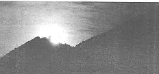
At sunset I climb to the highest point of the mountain, deserted except for the wind and a few stray mountain bees. To the south my view is blocked off by even higher peaks, but to the west i can see ridge after ridge of steep, dark mountains. In the east the full moon is rising, and below it the lights of distant El Centro are beginning to sparkle. To the north the last rays of the sun glint on the Salton Sea. The government’s criteria for evaluating a potential wilderness places heavy emphasis on the opportunities it offers for solitude; the BLM even defines solitude in their wilderness inventory booklet as (1) the state of being alone or remote from habitations; (2) a lonely, unfrequented, or secluded place. It is encouraging that the federal government has come to understand the value of such places, although just how seriously they believe in the concept remains to be seen. Ultimately, solitude is a subjective judgment, but right now I’d define it as sitting on top of an abandoned copper mine in the Jacumba Mountains, watching the light fade and listening to great homed owls hooting in the canyons all around me.
Later that night I am awakened by an unmistakable roar: motorcycles. In the darkness below me, less than a mile away, I can see lights, and snatches of conversation drift up on the wind. I think of the beer bottles I saw earlier in the day, lying by the side of the road, a few even gleaming from within one of the entrances to the abandoned mine. No one in his right mind would carry a six-pack of beer up here in a backpack. If vehicles were banned from this area, the litter would gradually disappear. Most of the roads would wash out in the first few storms, and anyone could come up here (this place is only a few miles from the highway, after all) and for a few hours or days forget about telephones, washing machines, bawling babies, dirty bathtubs, bank accounts, rent bills, deadlines, elections, nuclear accidents, cars, trucks, motorcycles. Anyone could come up here and listen for the sound of the moon as it sails across the night sky.
Arnold Schoeck is not your typical out-doorsy type. With his curly black hair, impish smile, and nasal accent, he looks and sounds as if he’d be more at home on the streets of Philadelphia than in the desert. As a matter of fact, Philadelphia is where he is from. But Schoeck has a master’s degree in forestry from the University of Washington, worked for the National Park Service in the state of Washington for several years, and today is wilderness coordinator for the BLM’s El Centro office. His favorite outdoor recreation is whitewater kayaking, but a few weeks ago Schoeck and a friend made a three-day trip on foot across area 368, from the Jacumba Mountains to the Yuha Basin. There are no roads or trails through most of this area, and the going, he says, was rough. When he got back, though, his friends were most surprised not about the fact that he had done it at all, or that he hadn’t been concerned about rattlesnakes, mountain lions, and rabid coyotes, but by the fact that he hadn’t taken a gun to protect himself from the smugglers and illegal aliens who are sometimes seen in the area.
At the moment, Schoeck is driving one of the Bureau’s jeeps over a rough dirt road that winds up the Davies Valley in the eastern part of the Jacumba Mountains. On all sides of us is a wide plain covered with creosote, cholla, salt bush, and a variety of other shrubs typical of the low desert. A little while ago Schoeck told me that if we drive far enough on this road we may cross into Mexico without even realizing it. The landscape is vast and primitive, and there are no markers and no fences to speak of. “The BLM’s plan is to come up with an overall balanced plan for multiple use of the desert,” he says. “Part of that is to establish wilderness areas. The question is how many and how big they should be. Basically, the Bureau’s policy is to let the politicians make their desires known, then we carry out their instructions. We’re not here to tell the Congress what to do. I expect they’ll take our recommendation seriously, but I hope they’ll also listen to their constituents and modify it on their own.”
Schoeck is well versed in the Bureau’s growing mass of regulations, one of the most controversial of which is the definition of a road. Off-road-vehicle enthusiasts tend to claim any route that is used regularly constitutes a road, a definition that gives the desert thousands of roads and would eliminate many areas from consideration as wilderness. But Schoeck says that “just because people go back and forth on it doesn’t mean that it’s a road. This road we’re on. for instance las he says this we are crawling up over a rocky ridge; the jeep bounces and pitches at a dangerous angle before righting itself and allowing us to continue], is a road here in the lower part of the valley, but up higher it’s not. That’s because in the lower part it provides access to a documented mining claim. To be consistent with Congress’s definition, a road not only has to be maintained, but used for an active purpose.”
Suddenly the jeep’s radio crackles and a man’s voice comes on. It is the dispatcher in the BLM’s Riverside office, responding to a call from a Bureau employee whose jeep has stalled in a remote area. For some reason we cannot hear both sides of the conversation, only the voice of the dispatcher as he maintains radio contact and tries to pinpoint the employee’s whereabouts. “Where exactly are you? We’re having trouble finding anyone who knows the area.”
We round a hilltop and pass into a valley where hundreds of yucca stalks loom out of the desert scrub like trees. In the shade of one of them sits an enormous jackrabbit, eyeing us warily as we continue on up the road. The problem in implementing a multiple-use plan for the desert, Schoeck continues, is that most of the possible uses are mutually exclusive. An area that is used for mining, for example, can’t be used for off-road vehicles, and an area open to off-road vehicles isn’t much good for hiking or solitude. “Personally,” he says, “I’m in favor of wilderness. I think we need it. But one thing everyone involved seems to agree on is that the desert should be used for a variety of things.” This is the BLM’s quintessential viewpoint, a viewpoint that some call objective and some call wishy-washy. Traditionally, in spite of a good deal of rhetoric about preserving natural areas, the government has come down on the side of developmental interests. Anyone who has been to Yellowstone or Yosemite national parks recently can verify this. On the other hand, it is only recently that laws were passed which officially recognized the value of undeveloped land.
The radio crackles again. “Wait a minute - Sam’s going to take directions, and talk slowly because he's writing them out in longhand.”
Ultimately, one of the problems with establishing wilderness areas is the expense of enforcing the regulations necessary to maintain them. Do you build a fence around Paradise? Or hire a huge patrol force to ticket each person who rambles through illegally in a truck? “There are definitely going to be problems along that line,” admits Schoeck. “Some will have to be decided by trial and error. We ’re trying to put together in four years a plan similar to what the National Park Service has been working on since the 1890s.”
"I've got a map that says . . . Ocotillo Way,” says the Riverside dispatcher. A pause. "It’s going to be hard for us to get a tow-truck in there.”
One thing seems clear: The BLM will get an increasing share of the government’s land-management funds as more and more of its land is set aside for a particular use. And as that happens, the BLM will likely put more of those funds into roads, campgrounds, and visitors’ centers, much like the National Park Service. Already the BLM has instituted forty-two camping areas in California that are accessible to all types of vehicles, and a sleek new tourist Way Station, the first of several, was completed in Barstow in 1974.
"Stay in your vehicle until I give you the word to start walkin' up that road.”
Schoeck brings the jeep to a halt in the middle of a rocky wash. Dust and heat and silence rise up all around us. In response to my question, he acknowledges that access to a particular wilderness area may eventually require reservations and use permits, much like state parks such as those in the Sierra Nevada. These days it’s the only way to protect an area from getting overloaded with people. “In some areas, camping can break down the land just like 'vehicle use,” he points out. “It takes more people, but. ...” Schoeck looks out across the valley and says he hopes if it comes to that, the BLM will have fewer regulations and fewer intrusions such as trails, trailmarkers, toilets, developed campgrounds. He hopes the BLM won't become a big brother to those who want to see some of the last few places on earth that man has had humility enough to leave alone.
“Hold on - Tyler's coming out,” says the dispatcher. “He says he thinks he knows approximately where you are. . . . We’ll just keep our fingers crossed.”
Here's something you might be interested in.
Rangers vs. the buggies in the Algodones Dunes
Who owns the desert?
Rangers vs. the buggies in the Algodones Dunes
Who owns the desert?
“Some of these off-road-vehicle people claim that they don 't do any damage to the desert. They say, 'We just leave tracks.'"
The wind picks up; here and there sand drifts across the blacktop like wisps of cloud. On either side of the highway the dunes extend to the horizon, tan, impassive giants with sparse scrub clinging to their sides. The plants are nearly all some shade of pastel — sun-bleached blue, pale dusty green — and look much too fragile to survive the withering heat of the sun. Yet there they are, swaying stiffly in the gusts of wind, a symbol of moisture and life somewhere beneath the mounds of sand.
Dave Krouskop: "People out here have gone pretty much anywhere they pleased and done anything they wanted to do.’’
We are driving — Dave Krouskop and I — through the Algodones Dunes, one of the more unusual features of the southernmost of California's two deserts, the Colorado. Krouskop is a desert ranger out of the Bureau of Land Management’s field office in El Centro; his sturdy features are dominated by a bushy brown moustache. As he steers his jeep down the highway he scans the landscape on all sides. Summer has arrived, and with the temperature hovering around ninety degrees Fahrenheit (it is ten in the morning) the dunes are relatively deserted. A few dune buggies can be seen racing across the sand to the south, but this is a far cry, Krouskop explains, from the thousands of people who were here over the recent Memorial Day weekend.
“Actually, that isn't such an unusual speed out here.”
Like almost every other place, the California desert is getting crowded. The BLM’s information shows that more than sixteen million people live within 200 miles of some part of it, and this figure is expected to reach twenty million within a few years. About fifteen years ago this population boom began to cause bitter disputes among various groups who visited or lived in the desert. Environmentalists complained that the landscape was being torn up by motorcycles, dune buggies, trucks, and jeeps. The drivers of the vehicles complained that it wasn't fair to close certain areas to them in order to appease a few environmentalists. Meanwhile mining companies were petitioning for permission to excavate minerals and precious metals; wildlife biologists spoke of endangered species; utilities wanted rights of way for power lines and energy resource exploration. For years the BLM had administered its 473 million acres nationwide, including 12.5 million acres in the California desert, more or less passively. But in that time the public consciousness had changed. Now people were demanding that the BLM do more with its land than simply own it.
Davies Valley. On all sides of us is a wide plain covered with creosote, cholla, salt bush, and other shrubs.
Out of disputes like those over the desert grew the Federal Land Policy and Management Act, which directed the BLM to come up with a comprehensive multiple-use plan for its land holdings. It is the type of law that gains a minimum amount of public attention when it is passed and has a maximum impact on peoples’ lives for years to come. Officially the Congress gave the BLM fifteen years to ready its plan, but because the disputes in California’s desert had grown particularly critical. the Act created the special California Desert Conservation Area (CDCA), and gave the BLM just four years to recommend which areas within it were to be mined, which to be developed, which to be utilized for motorized recreation, and which to be preserved in their natural state.
"ORV enthusiasts still have unrestricted access to eighty-two percent of the dunes.”
That was in 1976; now there is only one year left, and the pressure on the BLM is mounting.
Krouskop turns off the highway onto a narrow blacktop road and drives to the top of a large dune. Below us a man and woman in a dune buggy maneuver slowly through a valley of sand. For miles in every direction, as far as one can see across the shimmering plain, the major landholder is the BLM. There are exactly 377 separate tracts of Bureau-owned land in the Desert Conservation Area, one-eighth of California's total land. One of Krouskop’s duties as ranger is to protect these tracts in their present condition, until their final use is determined by Congress.
But in the five years he has been a ranger the BLM has successfully prosecuted only one violator, and that was a man who had illegally built a house in the Jacumba Mountains. As he tells me this, Krouskop, who is generally rather serious, smiles thinly. “Traditionally, people out here have gone pretty much anywhere they pleased and done anything they wanted to do,’’ he says. “They’ve felt nobody’s going to bother them — and they’re right. For the last twenty or thirty years, nobody has.”
Twenty million years ago the climate of most of California’s desert was tropical. Rain fell heavily in the summer months, and the land was a network of rivers and freshwater lakes. Giant tree ferns grew abundantly, and primitive mammals roamed the area, including mastodons, rhinoceros, and the small three-toed horse Mesohippus. Hawks soared over the canyons, and in the ground the ancestors of rodents burrowed and raised their young. But the earth began to change as volcanoes erupted and huge plates of the earth’s crust shifted and ground into each other. Rocked by earthquakes, ancient Southern California's plains sank, forming an oval-shaped basin over 200 miles long.
At the same time the Peninsular ranges, including the Laguna Mountains, were pushed up, and thus cut off the flow of moisture-laden air from the coast. The winds still came incessantly from the west, but now they were burning and dry. Gradually the lakes and rivers began to disappear. The ferns and other plants died, and the mammals moved or suffered the same fate — all except the rodents, who learned to live without drinking. The soil that once supported life grew dry and coarse, and the winds picked it up and swirled it across the newly created basin, piling it up in huge mounds near the mountains on the eastern side. These mounds — 400 feet deep in some places — are still growing, and have come to be known as the Algodones Dunes.
As far as the BLM is concerned, the dunes fall into Dave Krouskop’s “patrol sector,” a tract bounded roughly by the dunes themselves on the north and west, the Colorado River on the east, and on the south by the international border with Mexico. Within this area of more than two million acres the BLM is responsible for about half the land; Krouskop is the Bureau’s only agent who visits any of it regularly. Krouskop has been a desert ranger since 1973. when the desert ranger program was first developed. Now thirty-eight years old. he has a bachelor’s degree in outdoor recreation and management from Colorado State University at Boulder, and worked for the National Park Service in.Texas before going to work for the BLM in El Centro. The ranger program first began, he tells me, in order to insure that the BLM's new regulations in certain areas of the desert were carried out. But the rangers had no authority to issue citations or make arrests, and they were often simply ignored. In 1977 new legislation empowered the rangers to make arrests, but still withheld from them the power to issue citations. “So now it’s kind of an all-or-nothing situation,” Krouskop shrugs. “But you don’t want to make an arrest if you can possibly avoid it; it creates a bad image.” In the two years since the rangers have had arrest authority, not a single arrest has been made.
Krouskop laments the rangers’ ineffectiveness in policing BLM land, but claims that his job consists of more than just enforcing regulations. He says he looks for hazards (such as abandoned mines or live artillery shells left over from training maneuvers during World War II), gives emergency medical attention to injured drivers and hikers, searches for lost dogs, kids, and adults. His mode of transportation is a late-model jeep that he drives as much as 250 miles a day. It is equipped with two cameras, a shovel, a mirror and compass, two dozen flares, five gallons of water, smoke bombs, a fire extinguisher, oxygen, medical supplies, a winch, a tow strap, a jack, chains, a tire pump, binoculars, field guides for birds and mammals, maps, brochures, and a billy club — not to mention his thermos of coffee, two-way radio, and the tricolored (lashing lights on the roof of the cab, “Just basically what I need,” he says, “and not much more.” Nosing his jeep back onto Highway 78, Krouskop explains that nearly all of the visitors to the Algodones Dunes are offroad vehicle enthusiasts. The big crowds come from September to April, since the temperatures then are more tolerable — and not just for people. In the full heat of summer, or around 120 degrees Fahrenheit, the air-cooled engines that power most of the ORVs can’t cool themselves fast enough; they blow up. As we head eastward toward Glamis, Krouskop points to the north and south sides of the highway. The north side, an area closed to vehicles, is covered with low scrub, but the southern side, where vehicles are free to travel anywhere, is virtually bare. “Some of these off-road-vehicle people claim that they don 't do any damage to the desert,” he says. “They say, 'We just leave tracks; the first wind will cover them up.’ I always use the contrast between these two areas to show them that they do make a lasting effect.”
For their part, the off-road-vehicle people complain that the BLM is locking up the desert. In particular, they oppose the possibility that some areas may be designated “wilderness,” a special distinction under the Federal Land Policy and Management Act which would close an area permanently to vehicular travel, mining, and anything else that might significantly alter the pristine quality of the landscape. From 1978 to 1979 the BLM spent a full twelve months in an effort to identify any lands they control which might qualify for designation as wilderness. Two such areas have been identified in the dunes, and they have been at least temporarily closed to vehicles. “But they [the ORV enthusiasts] still have unrestricted access to eighty-two percent of the dunes,” Krouskop points out.
Vehicle travel in potential wilderness areas is generally restricted to existing major roads because, by law, the BLM must maintain these areas in their current state until their final use is determined by Congress. One of the results of this approach is that Krouskop, as a visible representative of the federal government, from time to time encounters hostile vehicle operators who resent being told where and how fast to drive, and generally think the BLM is trying to lay down a set of screwy regulations. As we pass into Glamis — a place that, with two buildings (one unoccupied), a small graveyard, and no electricity, bears a remarkable resemblance to its symbol on maps of the state, a small, hollow circle — he points to a sign that bears some of the antigovernment sentiment:
- Welcome to Glamis
- Speed Limit 95 m.p.h.
“Actually, that isn't such an unusual speed out here,” Krouskop observes, turning left onto a wide, gravelly county road. We head north, skirting the eastern edge of the dunes. “One evening a few weeks ago a guy on a Harley tried to take a turn in the road near Gekko Campground at about ninety. He didn’t make it, of course. He flew about 150 feet before he landed. I came by a little later and saw a group of people down off to the side of the road. I shined my light down there, and someone yelled up, 'You better come down here.’ When I got there the guy was lying face down in the sand. His face just right in the sand. I turned him over and gave him some oxygen, and after a while he started breathing on his own. Eventually we hauled him out and took him to the hospital, but as far as I know he never regained consciousness.”
The unpaved road stretches on and on and on. To our right rises the jagged blue ridge of the Chocolate Mountains; to our left is one of the two areas of the dunes that have been closed to vehicles (species of rare plants were discovered there). Krouskop has been peering into the scrub at the side of the road for some time, and now suddenly slows when he espies the end boundary of the closed area. Swinging off the main road we set out on a spine-jarring course toward a high ridge of the dunes about half a mile away. Lizards flee to cover at our approach. Whole plants disappear under the jeep’s hood and are ground into the sand by our tires. As we pass over a given patch of ground we leave wide tracks behind showing where we have been; the impressions are sharp and clearly visible. “The desert is a vast world, an oceanic world,” wrote Edward Abbey in Desert Solitaire, “as deep in its way and complex and various as the sea. ” In a few months our tracks here will probably disappear in the constant shifting of wind and sand, but elsewhere in the desert they would remain for thirty, forty, perhaps fifty years or more, preserved by the arid air and lack of rain, like a boat wake set in cement.
A man I spoke to in San Diego, a man whose sentiment runs toward preserving the environment, warned me at the outset, “Don’t make this out to be a war between ORV people and conservationists; the issues are much more complex than that.” In this he was absolutely right. In question is the whole attitude of man toward his environment. Nevertheless, even this man admitted that the conflict between ORV enthusiasts and conservationists is one of the “high profile” issues. And it is clear that this conflict and the questions it almost immediately raises — restricted or unrestricted access to desert areas, preservation or exploitation — are on the minds of nearly everyone who visits or lives in the desert. A few months ago I made a trip to the Fish Creek Mountains, a massive granite ridge that rises some 2500 feet out of the desert plain in Anza Borrego State Park. My companion and I drove for more than an hour up a dusty wash, to a place where the only sounds were the wind and the high, eerie twittering of white-throated swifts that periodically made forays from their cliffsidc nests fifty feet above us. We had been there only a few minutes when a low hum told us of the approach of another vehicle. Soon a dune buggy appeared carrying a family of four, who parked not thirty feet away, got out, and began talking loudly about the "environmentalists” who wanted to close large portions of the desert to vehicles. “I stay on the roads. I obey the regulations,” the father, a burly man covered with a fine layer of dust, told his son, “because I don’t want to give them any ammunition for their cause.” After a pause he added, ”’Course, we believe the only way you can see the desert is in a vehicle of some sort. You can’t hike to most of these areas because there’s no water.” Fifteen minutes later they all got back into the dune buggy and disappeared down the wash, leaving us to forever wonder if they had noticed the airborne swifts.
The split between conservationists and ORV people was dramatically demonstrated at a public hearing the BLM held at the SDG&E auditorium in downtown San Diego last December. The meeting marked the end of the preliminary inventory of all areas which would be studied for potential wilderness designation, and the BLM was soliciting comments that might pertain to specific areas. More than one hundred people showed up — the largest crowd at any such public hearing in the state, according to the BLM’s records. Presiding over the gathering was a judge from the Department of the Interior, who was flanked by two BLM officials. Below the dais sat a court reporter wearing glasses and a nondescript gray suit, repeating the proceedings rapidly and quietly into the microphone of a portable tape recorder.
From the beginning the battle lines were clearly drawn. The opposing groups were characterized by their dress as much as anything else: the conservationists wore plaid flannel shirts and jeans; the ORV people, who included several car and motorcycle clubs, wore brightly colored nylon jackets or T-shirts with car insignias on them; a third group, made up principally of elderly men who described themselves as “admitted rock-hounds,” wore sport coats, slacks, and string ties.
The most hotly disputed item of the evening was the question of what constituted a wilderness area and how such a designation would affect public access to that area. Frank Norris of the Sierra Club was the first to speak, and he urged that wilderness be given a high priority in the BLM’s overall plan. After that he named some thirty areas that he felt deserved particular attention. Several rock-hounds spoke next, including Clarence Ritter of Chula Vista, who charged that wilderness designation would essentially prevent children, senior citizens, and many others from visiting an area, since such people cannot generally hike very far (a wilderness area must have a minimum of 5000 acres). This was particularly true in the desert, Ritter noted, where “one cannot travel far without vehicular help.” Next, several ORV enthusiasts argued emotionally that the BLM’s definition of a road had been designed to limit vehicle access to the greatest possible extent. In particular, Richard Ramage of San Diego voiced suspicion about the BLM’s trend of closing more and more areas to vehicles. “Where will it stop?” he wondered, while the court reporter repeated his remarks into the microphone. After four hours of such comments, the judge from the Department of the Interior reiterated that the purpose of the hearing had been to gather information on specific areas, and, while most of the discussion had not addressed that concern, it would be filed and duly considered. Then he asked the BLM officials if they had any comments on the testimony. The BLM officials said no, they didn’t, and at a little after 11:00 p.m. everyone went home, wondering, perhaps, how government officials could always be so maddeningly noncommittal on subjects that were of such vital importance.
Several months later I contacted Frank Norris, a man whose intense dark eyes are made to look even darker and more intense by his shock of black hair and full beard. At twenty-eight, he is the president of a Sierra Club subcommittee on the desert, a group organized to monitor the progress of the BLM’s desert plan and to lobby for those decisions the Sierra Club feels are important. Their overall viewpoint is conservationist, and they have come to represent what their opponents, who sport bumper stickers such as Sierra Club: Go Hike To Hell, describe as knee-jerk environmentalism. I asked Norris about some of the questions raised at the hearing. He disagreed strongly with the general view that desert land should be kept accessible to the greatest number of people possible, and therefore vehicles, too. “What they’re saying is that their interest in not wanting to hike is more important than preserving the ecosystem,” he said simply.
Norris did say that parts of the desert should be reserved for off-road-vehicle use, and that some mining operations should continue. “I’m not a mining advocate, but I can see that certain areas may contain elements that are in the national interest to exploit,” he said. “But it takes an intermediary like the BLM for a confirmed ORVer and a conservationist to talk to each other. We think the ORV people are short-sighted. They seem to think God created the desert for man to go out in his vehicles in. When we go out to the desert, we see a lot of beauty, a lot of permanence, the ecosystem, the being of the desert. We’re concerned about what the desert will look like in one hundred years.”
Norris said he feels the BLM has done a good job providing information to the public and involving people in the data-gathering process. But he smiled when I mentioned the morass of regulations that surround public participation. “You definitely have to be into this whole process to know when to say what, and to whom, ” he commented. “But the BLM should be lauded for being as publicly oriented as it is.”
Richard Ramage, though, sharply criticized the BLM when I contacted him late last month. Ramage is the twenty-six-year-old president of Los Troqueros, a four-wheel-drive truck club based in San Diego. He steadfastly maintains that most ORV drivers stick to existing routes and do a minimal amount of damage to the landscape, and that most of the desert should therefore be kept open to vehicles. “The BLM is doing a terrible job,” he told me flatly. “My personal feeling is that they have these meetings just because it’s the law for them to do it before they make a big change. I’ve been to all the major meetings they’ve had. They ask for input, and we make comments and write letters with our suggestions . . . then it turns out they’re just going to close more areas. The input must go in the trash can.”
Ramage agreed there were some “fragile” areas of the desert that should be closed to vehicles, but said most of them had already been identified and closed. As for the many other desert areas the BLM might close to vehicles, he said a possible compromise would be to make them “designated roads and trails areas” — a BLM classification that limits vehicle travel and hiking to specific routes. “But 1 don’t think the environmentalists are willing to compromise,” he added.
In spite of the fact that he considers BLM officials unresponsive, Ramage said he will continue to attend public hearings. “What are you going to do?” he asked rhetorically. “If we don’t go at all, the environmentalists would think they could do anything they want. If we show up, it lets them know we’re still interested in certain things, and that probably has more effect than ‘input’ anyway.”
Area 368 on the BLM’s final wilderness inventory map is a roughly semicircular tract in the Jacumba Mountains between Interstate 8 and the international border with Mexico. It is about ten miles across from north to south, and varies in width from seven miles to just under eleven miles. Many of the areas on the BLM’s map are not being considered for possible designation as wilderness, but area 368 is; the description of it in the accompanying inventory booklet reads: “The western portion of this area consists of the Jacumba Mountains, which rise above the Yuha Basin and have impeded human travel and access for centuries. Landforms in the entire area range from the gently sloping, enclosed basin of Davies Valley to the steep-walled canyons and the pinnacles and spires of the higher summits. The area embraces secluded native palm oases and supports bighorn sheep. ...”
Anyone who has driven down the grade on Interstate 8 from Jacumba to El Centro knows just how rugged and imposing these mountains are. Lesser known is a dirt road that leads into the area a few miles east of Jacumba. As the afternoon sun begins to sink and the oppressive summer heat begins to abate, I coax my old Volkswagen sedan up this route, being as careful as is humanly possible not to tear out its mechanical innards once and for all on what might best be described as a rutted, tortuous path. A mile or so from the freeway I park it on a little bluff, hoist my backpack to my shoulders, and set off on foot.
The mountains around me are little more than huge rockpiles, the broken slabs of granite resting precariously upon each other, rich in pinkish quartz. June is late in the year for desert wildflowers, but because of the elevation here — nearly 3000 feet — a few hardy species are still in bloom: yellow choreopsis, cream-colored salt bush, here and there fiery red chuparosa. I follow the road as it winds into a rocky valley criss-crossed by sandy washes. In the distance the road curls up toward a mountaintop, the highest point of land in sight.
Hiking in the desert usually means, of course, carrying your own water. With an average rainfall of three to five inches a year, the Colorado Desert doesn’t have even one year-round river, and natural springs are few. The ideal solution would be to imitate the rodents and lizards; they don’t drink, they don't sweat, they don’t even urinate. By conserving this way they are able to get what little moisture they need from the food they eat. But humans are not as efficient as this, and most desert guidebooks will tell you that you need a minimum of one gallon of water a day. At about eight pounds a gallon, this limits somewhat your ability to trek indefinitely. But by avoiding the heat of midday, and keeping an eye out for rattlesnakes, scorpions, and certain species of ill-tempered spiders, one can hike in the desert as easily as one can hike anywhere else.
If an area were to be designated wilderness, hiking would be one of the more obvious things it could be used for, but it is certainly not the only thing. Such an area would also accommodate horseback riding, camping, rafting (where practical), picnics, birdwatching. Most have other, non-recreational values as well. In the Jacumba Mountains, for instance, wildlife biologists are intrigued by the diverse topography, which includes both low- and high-desert plant communities and variations between. Unique subspecies of lizards and ground squirrels are known to occur here, having hybridized, perhaps, in an effort to adapt to the varied terrain. The area also harbors bighorn sheep, a large and primitive mammal that has proved particularly sensitive to the encroachments of civilization. Bighorn sheep are on the federal endangered species list, and unless large portions of their native habitat are protected they will not survive.
It takes several hours to reach the mountaintop on the far side of the valley, and when I do, I find it is the site of an abandoned mine. An ancient metal cannister lies rusting among rocks on the hillside, and further up the road are gaping holes that lead deep into the mountain. It is impossible not to wonder what was mined here, and what sort of story lies behind it. A solitary miner with an image of the girl he hoped to marry someday? A corporate group, meeting deadlines and fixed yields per ton of ore? A few hours later, looking for rocks with which to anchor my tent, I discover the answer to half the riddle: a rock streaked with deep, brilliant blue — copper.
At sunset I climb to the highest point of the mountain, deserted except for the wind and a few stray mountain bees. To the south my view is blocked off by even higher peaks, but to the west i can see ridge after ridge of steep, dark mountains. In the east the full moon is rising, and below it the lights of distant El Centro are beginning to sparkle. To the north the last rays of the sun glint on the Salton Sea. The government’s criteria for evaluating a potential wilderness places heavy emphasis on the opportunities it offers for solitude; the BLM even defines solitude in their wilderness inventory booklet as (1) the state of being alone or remote from habitations; (2) a lonely, unfrequented, or secluded place. It is encouraging that the federal government has come to understand the value of such places, although just how seriously they believe in the concept remains to be seen. Ultimately, solitude is a subjective judgment, but right now I’d define it as sitting on top of an abandoned copper mine in the Jacumba Mountains, watching the light fade and listening to great homed owls hooting in the canyons all around me.
Later that night I am awakened by an unmistakable roar: motorcycles. In the darkness below me, less than a mile away, I can see lights, and snatches of conversation drift up on the wind. I think of the beer bottles I saw earlier in the day, lying by the side of the road, a few even gleaming from within one of the entrances to the abandoned mine. No one in his right mind would carry a six-pack of beer up here in a backpack. If vehicles were banned from this area, the litter would gradually disappear. Most of the roads would wash out in the first few storms, and anyone could come up here (this place is only a few miles from the highway, after all) and for a few hours or days forget about telephones, washing machines, bawling babies, dirty bathtubs, bank accounts, rent bills, deadlines, elections, nuclear accidents, cars, trucks, motorcycles. Anyone could come up here and listen for the sound of the moon as it sails across the night sky.
Arnold Schoeck is not your typical out-doorsy type. With his curly black hair, impish smile, and nasal accent, he looks and sounds as if he’d be more at home on the streets of Philadelphia than in the desert. As a matter of fact, Philadelphia is where he is from. But Schoeck has a master’s degree in forestry from the University of Washington, worked for the National Park Service in the state of Washington for several years, and today is wilderness coordinator for the BLM’s El Centro office. His favorite outdoor recreation is whitewater kayaking, but a few weeks ago Schoeck and a friend made a three-day trip on foot across area 368, from the Jacumba Mountains to the Yuha Basin. There are no roads or trails through most of this area, and the going, he says, was rough. When he got back, though, his friends were most surprised not about the fact that he had done it at all, or that he hadn’t been concerned about rattlesnakes, mountain lions, and rabid coyotes, but by the fact that he hadn’t taken a gun to protect himself from the smugglers and illegal aliens who are sometimes seen in the area.
At the moment, Schoeck is driving one of the Bureau’s jeeps over a rough dirt road that winds up the Davies Valley in the eastern part of the Jacumba Mountains. On all sides of us is a wide plain covered with creosote, cholla, salt bush, and a variety of other shrubs typical of the low desert. A little while ago Schoeck told me that if we drive far enough on this road we may cross into Mexico without even realizing it. The landscape is vast and primitive, and there are no markers and no fences to speak of. “The BLM’s plan is to come up with an overall balanced plan for multiple use of the desert,” he says. “Part of that is to establish wilderness areas. The question is how many and how big they should be. Basically, the Bureau’s policy is to let the politicians make their desires known, then we carry out their instructions. We’re not here to tell the Congress what to do. I expect they’ll take our recommendation seriously, but I hope they’ll also listen to their constituents and modify it on their own.”
Schoeck is well versed in the Bureau’s growing mass of regulations, one of the most controversial of which is the definition of a road. Off-road-vehicle enthusiasts tend to claim any route that is used regularly constitutes a road, a definition that gives the desert thousands of roads and would eliminate many areas from consideration as wilderness. But Schoeck says that “just because people go back and forth on it doesn’t mean that it’s a road. This road we’re on. for instance las he says this we are crawling up over a rocky ridge; the jeep bounces and pitches at a dangerous angle before righting itself and allowing us to continue], is a road here in the lower part of the valley, but up higher it’s not. That’s because in the lower part it provides access to a documented mining claim. To be consistent with Congress’s definition, a road not only has to be maintained, but used for an active purpose.”
Suddenly the jeep’s radio crackles and a man’s voice comes on. It is the dispatcher in the BLM’s Riverside office, responding to a call from a Bureau employee whose jeep has stalled in a remote area. For some reason we cannot hear both sides of the conversation, only the voice of the dispatcher as he maintains radio contact and tries to pinpoint the employee’s whereabouts. “Where exactly are you? We’re having trouble finding anyone who knows the area.”
We round a hilltop and pass into a valley where hundreds of yucca stalks loom out of the desert scrub like trees. In the shade of one of them sits an enormous jackrabbit, eyeing us warily as we continue on up the road. The problem in implementing a multiple-use plan for the desert, Schoeck continues, is that most of the possible uses are mutually exclusive. An area that is used for mining, for example, can’t be used for off-road vehicles, and an area open to off-road vehicles isn’t much good for hiking or solitude. “Personally,” he says, “I’m in favor of wilderness. I think we need it. But one thing everyone involved seems to agree on is that the desert should be used for a variety of things.” This is the BLM’s quintessential viewpoint, a viewpoint that some call objective and some call wishy-washy. Traditionally, in spite of a good deal of rhetoric about preserving natural areas, the government has come down on the side of developmental interests. Anyone who has been to Yellowstone or Yosemite national parks recently can verify this. On the other hand, it is only recently that laws were passed which officially recognized the value of undeveloped land.
The radio crackles again. “Wait a minute - Sam’s going to take directions, and talk slowly because he's writing them out in longhand.”
Ultimately, one of the problems with establishing wilderness areas is the expense of enforcing the regulations necessary to maintain them. Do you build a fence around Paradise? Or hire a huge patrol force to ticket each person who rambles through illegally in a truck? “There are definitely going to be problems along that line,” admits Schoeck. “Some will have to be decided by trial and error. We ’re trying to put together in four years a plan similar to what the National Park Service has been working on since the 1890s.”
"I've got a map that says . . . Ocotillo Way,” says the Riverside dispatcher. A pause. "It’s going to be hard for us to get a tow-truck in there.”
One thing seems clear: The BLM will get an increasing share of the government’s land-management funds as more and more of its land is set aside for a particular use. And as that happens, the BLM will likely put more of those funds into roads, campgrounds, and visitors’ centers, much like the National Park Service. Already the BLM has instituted forty-two camping areas in California that are accessible to all types of vehicles, and a sleek new tourist Way Station, the first of several, was completed in Barstow in 1974.
"Stay in your vehicle until I give you the word to start walkin' up that road.”
Schoeck brings the jeep to a halt in the middle of a rocky wash. Dust and heat and silence rise up all around us. In response to my question, he acknowledges that access to a particular wilderness area may eventually require reservations and use permits, much like state parks such as those in the Sierra Nevada. These days it’s the only way to protect an area from getting overloaded with people. “In some areas, camping can break down the land just like 'vehicle use,” he points out. “It takes more people, but. ...” Schoeck looks out across the valley and says he hopes if it comes to that, the BLM will have fewer regulations and fewer intrusions such as trails, trailmarkers, toilets, developed campgrounds. He hopes the BLM won't become a big brother to those who want to see some of the last few places on earth that man has had humility enough to leave alone.
“Hold on - Tyler's coming out,” says the dispatcher. “He says he thinks he knows approximately where you are. . . . We’ll just keep our fingers crossed.”
Comments