Here's something you might be interested in.
Ask a Hipster — Advice you didn't know you needed
Big Screen — Movie commentary
Blurt — Music's inside track
Booze News — San Diego spirits
Classical Music — Immortal beauty
Classifieds — Free and easy
Cover Stories — Front-page features
Drinks All Around — Bartenders' drink recipes
Excerpts — Literary and spiritual excerpts
Feast! — Food & drink reviews
Feature Stories — Local news & stories
Fishing Report — What’s getting hooked from ship and shore
From the Archives — Spotlight on the past
Golden Dreams — Talk of the town
The Gonzo Report — Making the musical scene, or at least reporting from it
Letters — Our inbox
Movies@Home — Local movie buffs share favorites
Movie Reviews — Our critics' picks and pans
Musician Interviews — Up close with local artists
Neighborhood News from Stringers — Hyperlocal news
News Ticker — News & politics
Obermeyer — San Diego politics illustrated
Outdoors — Weekly changes in flora and fauna
Overheard in San Diego — Eavesdropping illustrated
Poetry — The old and the new
Reader Travel — Travel section built by travelers
Reading — The hunt for intellectuals
Roam-O-Rama — SoCal's best hiking/biking trails
San Diego Beer — Inside San Diego suds
SD on the QT — Almost factual news
Sheep and Goats — Places of worship
Special Issues — The best of
Street Style — San Diego streets have style
Surf Diego — Real stories from those braving the waves
Theater — On stage in San Diego this week
Tin Fork — Silver spoon alternative
Under the Radar — Matt Potter's undercover work
Unforgettable — Long-ago San Diego
Unreal Estate — San Diego's priciest pads
Your Week — Daily event picks
Hedgehog, teddy bear, staghorn
A wagon road in Plum Canyon is difficult to fathom.
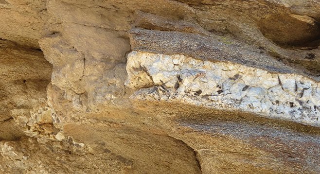
Black tourmaline is visible in a pegmatite dike.
There are no plum trees in Plum Canyon. It is possibly a misnomer caused by incorrectly identifying a desert apricot tree as a desert plum. In fact, there are no desert plums in the Anza-Borrego area. A plant that is similar to a desert apricot that is also found in this region is the desert almond, but not in Plum Canyon. Another possibility for the name of the canyon is attributed to cattleman John McCain who, with his brother, constructed a wagon road through to Plum Canyon to travel between the Shelter or Earthquake Valley and Yaqui Well sometime before 1913, many years before SR-78 was constructed. McCain grew plums on his ranch in Julian in the 1890s, so perhaps there is a connection there. An earlier name for this canyon was Wagon Wash, named for the wagon road that the McCains constructed.
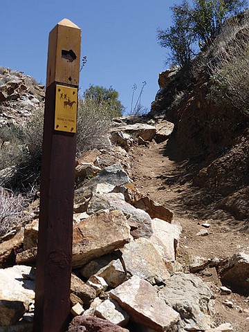
Horses are allowed on the California Riding and Hiking Trail.
Today it is difficult to fathom that a wagon road cut through from Shelter/Earthquake Valley to Plum Canyon, as rockslides have made it impassable. However, as a hiking route it is well worth exploring. The California Riding and Hiking Trail (CRHT) follows upper Plum Canyon and continues on to the Pinyon Mountain Road in Shelter Valley and then on into Blair Valley. The canyon has a wide diversity of plants because of its location in the Desert Transition Zone with 175 taxa identified. Beginning the hike at the entrance to Plum Canyon makes for a longer but more interesting hike, as it is a good way to experience the transition from lower elevation desert vegetation to the lower part of the Desert Transition Zone. Plum Canyon is a favorite for the California Native Plant Society.
At about mile 1.4 from the entrance to Plum Canyon, the road forks. Go right. The dirt road ends at about mile 1.8. The shorter hike begins here. Plants to note in the lower elevation area includes agave, lavender, creosote, chuparosa, brittlebush, ocotillo, and a variety of cacti including hedgehog, teddy bear, and staghorn cholla. While hiking up the alluvial fan, note the many smoke trees that are found in the wash. Soon after leaving the upper parking area is the first encounter with apricot trees, California juniper, Mojave yucca, desert willow, and barrel cactus. This mixed transition area also has ephedra and acacia. Note the mistletoe found on the acacia.
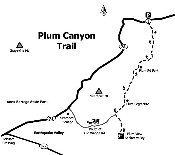
At 2.11 miles, the trail goes to the right and over a dry waterfall. A sign indicates that it is part of the CRHT and that horses are allowed on the trail. At 2.4 miles, look for a large and interesting pegmatite dike with quartz, black tourmaline, and wind caves on the right. About a quarter-mile further is a side canyon where the old Plum Canyon Road came into the wash from Shelter/Earthquake Valley. If exploring this side canyon, look for traces of the old wagon road. Continuing up the main wash, at 2.86 there is another CRHT sign before a steep climb that leads to the overview of Shelter/Earthquake Valley at elevation 2720 feet. The view of Granite Mountain is to the west. The start of the old wagon road is not visible from this point, as the view is blocked. Retrace steps back to your vehicle.
- Distance from downtown San Diego: About 78 miles. Allow 1 hour and 45 minutes. Drive to Julian via Ramona or Descanso and head east out of town on SR-78, driving about 12 miles down Banner Canyon to Scissors Crossing at the junction of SR-2. Continue driving on SR-78 for 4 miles to the entrance to Plum Canyon on the right/south side of the road after a sharp turn to the east. There is an option to either park here and begin the hike or drive 1.4 miles on a dirt road to a road fork, and take the right fork, driving an additional 0.4 mile to the end of the road and park.
- Hiking length: Either 6.34 or 2.76 — depending on where the hike begins — out and back. Allow 4 hours for the longer hike.
- Difficulty: Easy to moderate, depending on the length chosen. Elevation gain/loss on the longer hike is about 1000 feet, with the shorter hike close to 550 feet. No facilities. Carry water.
Here's something you might be interested in.
Hedgehog, teddy bear, staghorn
A wagon road in Plum Canyon is difficult to fathom.
Hedgehog, teddy bear, staghorn
A wagon road in Plum Canyon is difficult to fathom.
Black tourmaline is visible in a pegmatite dike.
There are no plum trees in Plum Canyon. It is possibly a misnomer caused by incorrectly identifying a desert apricot tree as a desert plum. In fact, there are no desert plums in the Anza-Borrego area. A plant that is similar to a desert apricot that is also found in this region is the desert almond, but not in Plum Canyon. Another possibility for the name of the canyon is attributed to cattleman John McCain who, with his brother, constructed a wagon road through to Plum Canyon to travel between the Shelter or Earthquake Valley and Yaqui Well sometime before 1913, many years before SR-78 was constructed. McCain grew plums on his ranch in Julian in the 1890s, so perhaps there is a connection there. An earlier name for this canyon was Wagon Wash, named for the wagon road that the McCains constructed.
Horses are allowed on the California Riding and Hiking Trail.
Today it is difficult to fathom that a wagon road cut through from Shelter/Earthquake Valley to Plum Canyon, as rockslides have made it impassable. However, as a hiking route it is well worth exploring. The California Riding and Hiking Trail (CRHT) follows upper Plum Canyon and continues on to the Pinyon Mountain Road in Shelter Valley and then on into Blair Valley. The canyon has a wide diversity of plants because of its location in the Desert Transition Zone with 175 taxa identified. Beginning the hike at the entrance to Plum Canyon makes for a longer but more interesting hike, as it is a good way to experience the transition from lower elevation desert vegetation to the lower part of the Desert Transition Zone. Plum Canyon is a favorite for the California Native Plant Society.
At about mile 1.4 from the entrance to Plum Canyon, the road forks. Go right. The dirt road ends at about mile 1.8. The shorter hike begins here. Plants to note in the lower elevation area includes agave, lavender, creosote, chuparosa, brittlebush, ocotillo, and a variety of cacti including hedgehog, teddy bear, and staghorn cholla. While hiking up the alluvial fan, note the many smoke trees that are found in the wash. Soon after leaving the upper parking area is the first encounter with apricot trees, California juniper, Mojave yucca, desert willow, and barrel cactus. This mixed transition area also has ephedra and acacia. Note the mistletoe found on the acacia.
At 2.11 miles, the trail goes to the right and over a dry waterfall. A sign indicates that it is part of the CRHT and that horses are allowed on the trail. At 2.4 miles, look for a large and interesting pegmatite dike with quartz, black tourmaline, and wind caves on the right. About a quarter-mile further is a side canyon where the old Plum Canyon Road came into the wash from Shelter/Earthquake Valley. If exploring this side canyon, look for traces of the old wagon road. Continuing up the main wash, at 2.86 there is another CRHT sign before a steep climb that leads to the overview of Shelter/Earthquake Valley at elevation 2720 feet. The view of Granite Mountain is to the west. The start of the old wagon road is not visible from this point, as the view is blocked. Retrace steps back to your vehicle.
- Distance from downtown San Diego: About 78 miles. Allow 1 hour and 45 minutes. Drive to Julian via Ramona or Descanso and head east out of town on SR-78, driving about 12 miles down Banner Canyon to Scissors Crossing at the junction of SR-2. Continue driving on SR-78 for 4 miles to the entrance to Plum Canyon on the right/south side of the road after a sharp turn to the east. There is an option to either park here and begin the hike or drive 1.4 miles on a dirt road to a road fork, and take the right fork, driving an additional 0.4 mile to the end of the road and park.
- Hiking length: Either 6.34 or 2.76 — depending on where the hike begins — out and back. Allow 4 hours for the longer hike.
- Difficulty: Easy to moderate, depending on the length chosen. Elevation gain/loss on the longer hike is about 1000 feet, with the shorter hike close to 550 feet. No facilities. Carry water.