Here's something you might be interested in.
Ask a Hipster — Advice you didn't know you needed
Big Screen — Movie commentary
Blurt — Music's inside track
Booze News — San Diego spirits
Classical Music — Immortal beauty
Classifieds — Free and easy
Cover Stories — Front-page features
Drinks All Around — Bartenders' drink recipes
Excerpts — Literary and spiritual excerpts
Feast! — Food & drink reviews
Feature Stories — Local news & stories
Fishing Report — What’s getting hooked from ship and shore
From the Archives — Spotlight on the past
Golden Dreams — Talk of the town
The Gonzo Report — Making the musical scene, or at least reporting from it
Letters — Our inbox
Movies@Home — Local movie buffs share favorites
Movie Reviews — Our critics' picks and pans
Musician Interviews — Up close with local artists
Neighborhood News from Stringers — Hyperlocal news
News Ticker — News & politics
Obermeyer — San Diego politics illustrated
Outdoors — Weekly changes in flora and fauna
Overheard in San Diego — Eavesdropping illustrated
Poetry — The old and the new
Reader Travel — Travel section built by travelers
Reading — The hunt for intellectuals
Roam-O-Rama — SoCal's best hiking/biking trails
San Diego Beer — Inside San Diego suds
SD on the QT — Almost factual news
Sheep and Goats — Places of worship
Special Issues — The best of
Street Style — San Diego streets have style
Surf Diego — Real stories from those braving the waves
Theater — On stage in San Diego this week
Tin Fork — Silver spoon alternative
Under the Radar — Matt Potter's undercover work
Unforgettable — Long-ago San Diego
Unreal Estate — San Diego's priciest pads
Your Week — Daily event picks
Schist and intrusions in Cool Canyon
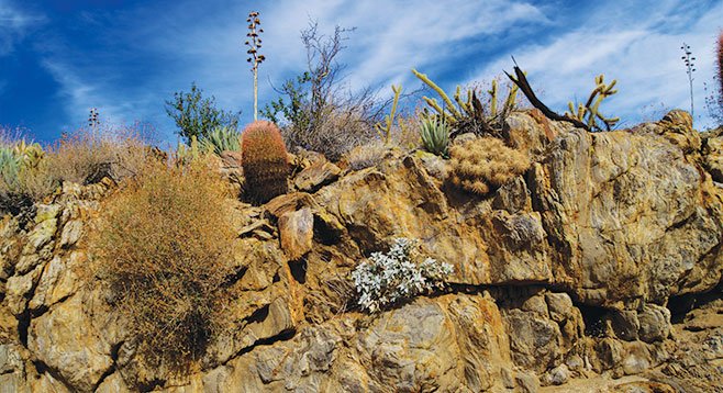
The canyon walls show displacement in metamorphic rock.
Cool Canyon is unlikely to be cool most of the year as far as the daytime temperature is concerned, but it is definitely cool in the colloquial sense. Hike up this east-west–oriented canyon and observe the change from the Sonoran desert scrub vegetation of Earthquake Valley to the foothill chaparral transition zone where you will find junipers and manzanita in an otherwise arid desert setting. The geology is fascinating, with large exposed expanses of colorful metamorphic schist with numerous intrusions of igneous granite and quartz.
There are no signs other than warnings that dogs and horses are not allowed, and there is no official trail. From the end of the road, start walking up the sandy Cool Canyon wash. The vegetation near the start of the hike includes Mojave yucca, burrobush, cheesebush, creosote bush, ocotillo, and catclaw. Sunflower-like plants commonly in flower here include brittlebush and Parish’s goldeneye, and while in season, there may also be flowering desert apricot and a variety of colorful flowering cacti, including Gander’s cholla, beavertail cactus, hedgehog cactus, and California barrel cactus. Blooming wildflowers might include apricot mallow, tidytips, sweetbush, chia, and phacelia, along with many others. The first mile is easy walking in soft sand with occasional small dry falls. The canyon walls include frequent outcroppings of colorful metamorphic Julian schist, a rock formation that held the gold that attracted miners to the Julian area in the 19th Century.
There is a more formidable barrier about one mile from the trailhead where a series of somewhat larger dry falls are encountered. If concerned, this might be a good place to turn back. The dry waterfalls can be surmounted without climbing skills, but a little bit of care is necessary. The canyon branches beyond these obstacles. Take the canyon to the right that heads in a westerly direction. Here the sandy walk continues with only a modest amount of boulder-hopping. On your left is a beautiful old California juniper with a gnarled trunk and a big berry manzanita growing next to it. Junipers are common here, as is agave, but manzanita is relatively rare.
At a little over 1.5 miles from the start of the hike, there will be thick brush in the canyon bottom. One option is to navigate up onto the ridge on the right and continue to the point where Earthquake Valley can be viewed. A more adventurous alternative would be to hike to the top of Granite Mountain from here, but that is beyond the scope of this trip. This also may be the best place to turn around and head back.
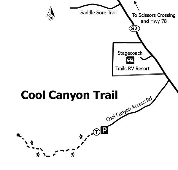
- Distance from downtown San Diego: 78.5 miles. Allow 1.5 hours (Earthquake/Shelter Valley). From SR-163N, merge onto I-8 E. Exit on SR-79N/Japatul Valley Rd. (Descanso), turning left, toward Julian, at the end of the ramp. After just under 3 miles, turn left to follow SR-79N to SR-78. Turn right/east on SR-78, away from Julian, and drive to Scissors Crossing, a distance of about 11 miles. Turn right on SR-2 and drive about 5 miles to an unsigned dirt road on the right/west, 1 mile past Stagecoach Trails RV Park. The Cool Canyon access road is a narrow and unimproved, mostly sandy road with a few rocks, but passenger cars should have no difficulty. Park at the end of the road, 1.3 miles from SR-2. There are no facilities or water.
- Hiking length: 3 miles out and back.
- Difficulty: Easy. Elevation gain/loss about 100 feet. Hiking is in a sandy canyon bottom with a few easy scrambles up dry waterfalls. Carry water.
Here's something you might be interested in.
Schist and intrusions in Cool Canyon
Schist and intrusions in Cool Canyon
The canyon walls show displacement in metamorphic rock.
Cool Canyon is unlikely to be cool most of the year as far as the daytime temperature is concerned, but it is definitely cool in the colloquial sense. Hike up this east-west–oriented canyon and observe the change from the Sonoran desert scrub vegetation of Earthquake Valley to the foothill chaparral transition zone where you will find junipers and manzanita in an otherwise arid desert setting. The geology is fascinating, with large exposed expanses of colorful metamorphic schist with numerous intrusions of igneous granite and quartz.
There are no signs other than warnings that dogs and horses are not allowed, and there is no official trail. From the end of the road, start walking up the sandy Cool Canyon wash. The vegetation near the start of the hike includes Mojave yucca, burrobush, cheesebush, creosote bush, ocotillo, and catclaw. Sunflower-like plants commonly in flower here include brittlebush and Parish’s goldeneye, and while in season, there may also be flowering desert apricot and a variety of colorful flowering cacti, including Gander’s cholla, beavertail cactus, hedgehog cactus, and California barrel cactus. Blooming wildflowers might include apricot mallow, tidytips, sweetbush, chia, and phacelia, along with many others. The first mile is easy walking in soft sand with occasional small dry falls. The canyon walls include frequent outcroppings of colorful metamorphic Julian schist, a rock formation that held the gold that attracted miners to the Julian area in the 19th Century.
There is a more formidable barrier about one mile from the trailhead where a series of somewhat larger dry falls are encountered. If concerned, this might be a good place to turn back. The dry waterfalls can be surmounted without climbing skills, but a little bit of care is necessary. The canyon branches beyond these obstacles. Take the canyon to the right that heads in a westerly direction. Here the sandy walk continues with only a modest amount of boulder-hopping. On your left is a beautiful old California juniper with a gnarled trunk and a big berry manzanita growing next to it. Junipers are common here, as is agave, but manzanita is relatively rare.
At a little over 1.5 miles from the start of the hike, there will be thick brush in the canyon bottom. One option is to navigate up onto the ridge on the right and continue to the point where Earthquake Valley can be viewed. A more adventurous alternative would be to hike to the top of Granite Mountain from here, but that is beyond the scope of this trip. This also may be the best place to turn around and head back.
- Distance from downtown San Diego: 78.5 miles. Allow 1.5 hours (Earthquake/Shelter Valley). From SR-163N, merge onto I-8 E. Exit on SR-79N/Japatul Valley Rd. (Descanso), turning left, toward Julian, at the end of the ramp. After just under 3 miles, turn left to follow SR-79N to SR-78. Turn right/east on SR-78, away from Julian, and drive to Scissors Crossing, a distance of about 11 miles. Turn right on SR-2 and drive about 5 miles to an unsigned dirt road on the right/west, 1 mile past Stagecoach Trails RV Park. The Cool Canyon access road is a narrow and unimproved, mostly sandy road with a few rocks, but passenger cars should have no difficulty. Park at the end of the road, 1.3 miles from SR-2. There are no facilities or water.
- Hiking length: 3 miles out and back.
- Difficulty: Easy. Elevation gain/loss about 100 feet. Hiking is in a sandy canyon bottom with a few easy scrambles up dry waterfalls. Carry water.