Here's something you might be interested in.
Ask a Hipster — Advice you didn't know you needed
Big Screen — Movie commentary
Blurt — Music's inside track
Booze News — San Diego spirits
Classical Music — Immortal beauty
Classifieds — Free and easy
Close to Home — What it’s like on the street where you live
Cover Stories — Front-page features
Drinks All Around — Bartenders' drink recipes
Excerpts — Literary and spiritual excerpts
Feast! — Food & drink reviews
Feature Stories — Local news & stories
Fishing Report — What’s getting hooked from ship and shore
From the Archives — Spotlight on the past
Golden Dreams — Talk of the town
The Gonzo Report — Making the musical scene, or at least reporting from it
Letters — Our inbox
Movies@Home — Local movie buffs share favorites
Movie Reviews — Our critics' picks and pans
Musician Interviews — Up close with local artists
Neighborhood News from Stringers — Hyperlocal news
News Ticker — News & politics
Obermeyer — San Diego politics illustrated
Outdoors — Weekly changes in flora and fauna
Overheard in San Diego — Eavesdropping illustrated
Poetry — The old and the new
Reader Travel — Travel section built by travelers
Reading — The hunt for intellectuals
Roam-O-Rama — SoCal's best hiking/biking trails
San Diego Beer — Inside San Diego suds
SD on the QT — Almost factual news
Sheep and Goats — Places of worship
Special Issues — The best of
Street Style — San Diego streets have style
Surf Diego — Real stories from those braving the waves
Theater — On stage in San Diego this week
Tin Fork — Silver spoon alternative
Under the Radar — Matt Potter's undercover work
Unforgettable — Long-ago San Diego
Unreal Estate — San Diego's priciest pads
Your Week — Daily event picks
Rock out in Rattlesnake Canyon
Geology is the highlight of this Anza-Borrego hike
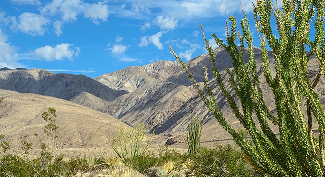
Approaching Rattlesnake Canyon
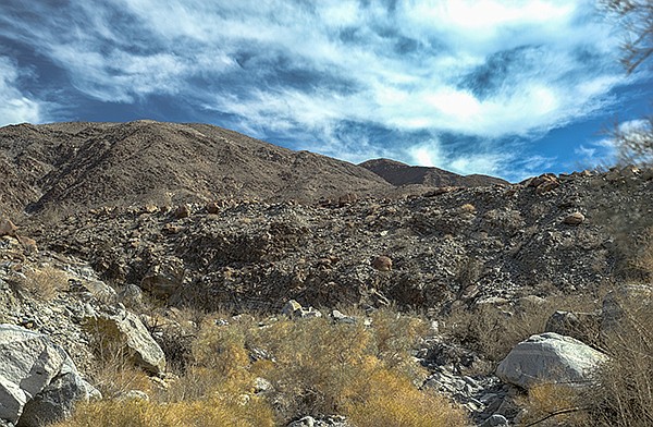
Rattlesnake Canyon's unconsolidated alluvial conglomerate
Rattlesnake Canyon is a large, deep canyon at the southern end of the Santa Rosa Mountains and one of the few canyons that flow north to south. It is a major conduit for alluvial material eroded from the Santa Rosas flowing into the Anza-Borrego desert. Here, one gets a look at the power water has to erode stone and rearrange the landscape.
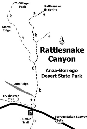
Begin hiking north across a sandy alluvial plain dotted with large ocotillo, creosote bush, and clumps of galleta grass. Initially the trail is not well marked except by footprints of those who have hiked this way before. Further ahead, the trail will be well marked with frequent cairns. The Santa Rosa Mountains and Rattlesnake Canyon are directly ahead, but they look closer than they are. The trail crosses the eastern-most end of Lute Ridge after 0.65 mile. Lute Ridge is a two-mile-long fault scarp composed of unconsolidated alluvial sand, gravel, and boulders that are being pushed up by movement along the Clark fault in the San Jacinto Fault Zone — it is said to be the largest fault scarp of this type in North America. The Clark fault is one of many highly active faults in the Anza-Borrego area.
At two miles long, Lute Ridge is the largest fault scarp of this type in North America.
In another 0.4 mile, the trail drops into Rattlesnake Canyon Wash, now headed west, carrying alluvial debris toward Clark Valley. Rattlesnake Canyon itself is entered at about 1.25 miles from the highway. The high walls of unconsolidated alluvial material rising high above you testify to the violence of the flash floods that have carved this canyon. Most of the trail up the canyon is through soft sand or skirts around large granite and metamorphic boulders.
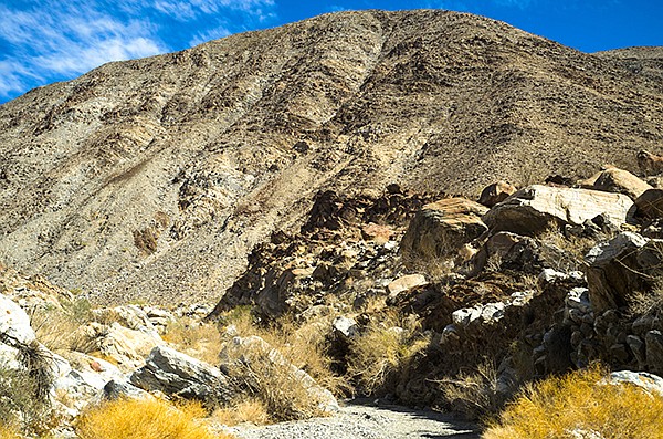
The Santa Rosa Mountains are composed mainly of the igneous granite-type rocks of the peninsular batholith, but these igneous rocks intruded into much older layers of metamorphic rocks initially formed as layers of sediment under an ancient ocean. Heat and pressure from thousands of feet of overlying material transformed the underlying sand, mud, and carbonate layers into metamorphic rocks, such as schist, marble, quartzite, and gneiss, which have been contorted and exposed by geological events.
Although the vegetation is rather sparse, it includes some large smoke trees, palo verde trees, catclaw acacia, and desert lavender, as well as many ocotillo and creosote bushes. Smaller common shrubs include brittlebush, burro bush, and cheese bush. Scattered cacti, including barrel cactus, beavertail cactus, pencil cholla, and teddy bear cholla, are more common on the canyon hillsides than in the flash-flood-prone canyon bottom. Look for a shrub with needle-like leaves that look as though they belong on a conifer. This is a member of the sunflower family known as the pygmy cedar, common elsewhere in the Sonoran Desert, but not frequently found in the Anza-Borrego.
At about 3.5 miles from the highway, the canyon makes a sharp turn to the east. Continuing up the canyon a little further is a dry fall, estimated to be about 40 feet high. In some years there has been a rope hanging down the fall to enable climbers to go beyond this point. However, unless you are an experienced rock climber, don’t attempt it! This is a good place to turn around and retrace your steps. On the way back, note the distinct line along the fault scarp and enjoy the view to the south.
Distance from downtown San Diego: About 100 miles. Allow 2.5 hours driving time. Drive to Christmas Circle in Borrego Springs via Julian or Ranchita. Go east 13 miles on SR-22 (the Salton Seaway) to milepost 31.8. Park at one of the turnouts on either side of the road. The one to the south is signed Thimble Trail. The one on the north is unsigned. The trail begins on the north side of the road.
Hiking length: 7.6 miles out and back.
Difficulty: Moderate with an elevation gain/loss of 1700 feet. There are a few small dry falls to climb, but none requiring rock-climbing skills. No facilities or water. Dogs and mountain bikes not allowed. Best time is between November and May.
Here's something you might be interested in.
Rock out in Rattlesnake Canyon
Geology is the highlight of this Anza-Borrego hike
Rock out in Rattlesnake Canyon
Geology is the highlight of this Anza-Borrego hike
Approaching Rattlesnake Canyon
Rattlesnake Canyon's unconsolidated alluvial conglomerate
Rattlesnake Canyon is a large, deep canyon at the southern end of the Santa Rosa Mountains and one of the few canyons that flow north to south. It is a major conduit for alluvial material eroded from the Santa Rosas flowing into the Anza-Borrego desert. Here, one gets a look at the power water has to erode stone and rearrange the landscape.
Begin hiking north across a sandy alluvial plain dotted with large ocotillo, creosote bush, and clumps of galleta grass. Initially the trail is not well marked except by footprints of those who have hiked this way before. Further ahead, the trail will be well marked with frequent cairns. The Santa Rosa Mountains and Rattlesnake Canyon are directly ahead, but they look closer than they are. The trail crosses the eastern-most end of Lute Ridge after 0.65 mile. Lute Ridge is a two-mile-long fault scarp composed of unconsolidated alluvial sand, gravel, and boulders that are being pushed up by movement along the Clark fault in the San Jacinto Fault Zone — it is said to be the largest fault scarp of this type in North America. The Clark fault is one of many highly active faults in the Anza-Borrego area.
At two miles long, Lute Ridge is the largest fault scarp of this type in North America.
In another 0.4 mile, the trail drops into Rattlesnake Canyon Wash, now headed west, carrying alluvial debris toward Clark Valley. Rattlesnake Canyon itself is entered at about 1.25 miles from the highway. The high walls of unconsolidated alluvial material rising high above you testify to the violence of the flash floods that have carved this canyon. Most of the trail up the canyon is through soft sand or skirts around large granite and metamorphic boulders.
The Santa Rosa Mountains are composed mainly of the igneous granite-type rocks of the peninsular batholith, but these igneous rocks intruded into much older layers of metamorphic rocks initially formed as layers of sediment under an ancient ocean. Heat and pressure from thousands of feet of overlying material transformed the underlying sand, mud, and carbonate layers into metamorphic rocks, such as schist, marble, quartzite, and gneiss, which have been contorted and exposed by geological events.
Although the vegetation is rather sparse, it includes some large smoke trees, palo verde trees, catclaw acacia, and desert lavender, as well as many ocotillo and creosote bushes. Smaller common shrubs include brittlebush, burro bush, and cheese bush. Scattered cacti, including barrel cactus, beavertail cactus, pencil cholla, and teddy bear cholla, are more common on the canyon hillsides than in the flash-flood-prone canyon bottom. Look for a shrub with needle-like leaves that look as though they belong on a conifer. This is a member of the sunflower family known as the pygmy cedar, common elsewhere in the Sonoran Desert, but not frequently found in the Anza-Borrego.
At about 3.5 miles from the highway, the canyon makes a sharp turn to the east. Continuing up the canyon a little further is a dry fall, estimated to be about 40 feet high. In some years there has been a rope hanging down the fall to enable climbers to go beyond this point. However, unless you are an experienced rock climber, don’t attempt it! This is a good place to turn around and retrace your steps. On the way back, note the distinct line along the fault scarp and enjoy the view to the south.
Distance from downtown San Diego: About 100 miles. Allow 2.5 hours driving time. Drive to Christmas Circle in Borrego Springs via Julian or Ranchita. Go east 13 miles on SR-22 (the Salton Seaway) to milepost 31.8. Park at one of the turnouts on either side of the road. The one to the south is signed Thimble Trail. The one on the north is unsigned. The trail begins on the north side of the road.
Hiking length: 7.6 miles out and back.
Difficulty: Moderate with an elevation gain/loss of 1700 feet. There are a few small dry falls to climb, but none requiring rock-climbing skills. No facilities or water. Dogs and mountain bikes not allowed. Best time is between November and May.