Here's something you might be interested in.
Ask a Hipster — Advice you didn't know you needed
Big Screen — Movie commentary
Blurt — Music's inside track
Booze News — San Diego spirits
Classical Music — Immortal beauty
Classifieds — Free and easy
Cover Stories — Front-page features
Drinks All Around — Bartenders' drink recipes
Excerpts — Literary and spiritual excerpts
Feast! — Food & drink reviews
Feature Stories — Local news & stories
Fishing Report — What’s getting hooked from ship and shore
From the Archives — Spotlight on the past
Golden Dreams — Talk of the town
The Gonzo Report — Making the musical scene, or at least reporting from it
Letters — Our inbox
Movies@Home — Local movie buffs share favorites
Movie Reviews — Our critics' picks and pans
Musician Interviews — Up close with local artists
Neighborhood News from Stringers — Hyperlocal news
News Ticker — News & politics
Obermeyer — San Diego politics illustrated
Outdoors — Weekly changes in flora and fauna
Overheard in San Diego — Eavesdropping illustrated
Poetry — The old and the new
Reader Travel — Travel section built by travelers
Reading — The hunt for intellectuals
Roam-O-Rama — SoCal's best hiking/biking trails
San Diego Beer — Inside San Diego suds
SD on the QT — Almost factual news
Sheep and Goats — Places of worship
Special Issues — The best of
Street Style — San Diego streets have style
Surf Diego — Real stories from those braving the waves
Theater — On stage in San Diego this week
Tin Fork — Silver spoon alternative
Under the Radar — Matt Potter's undercover work
Unforgettable — Long-ago San Diego
Unreal Estate — San Diego's priciest pads
Your Week — Daily event picks
Plenty of options on the trail to Hellhole Canyon
Trail options offer elevation loss up to 4000 feet through various life zones
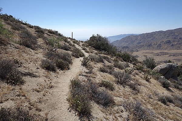
Part of the trail to Lower Hellholle Canyon
This 8-mile spur of the California Riding and Hiking Trail (CRHT) rewards hikers with a variety of desert habitats, providing exceptional views of the San Ysidro Mountains, Borrego Valley, Santa Rosa Mountains, and Salton Sea. It follows a ridge route between Hellhole Canyon and Dry Canyon in Anza-Borrego Desert State Park (ABDSP). Added attractions are seasonal wildflower and cactus blossom displays, a host of native birds, and possible encounters with mule deer and bighorn sheep as you descend from high desert vegetation to the Colorado Desert floor.
Authorized by the California State Legislature in 1945, the CRHT was envisioned as a statewide recreational trail stretching from San Diego County to the Oregon border. Over 1000 miles of improved trail were constructed or adopted across the state, including 100 miles in San Diego County. Marked with signature brown fence posts capped with yellow paint, the CRHT has been largely abandoned or subsumed by newer trails, modern roads, or realignments due in part to funding cuts in the 1960s and private property access issues. Fortunately, a few stretches remain in nearly their original form.
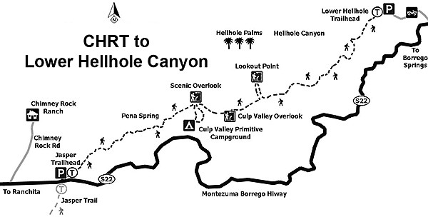
Map to Lower Hellhole Canyon
This hike descends a spur segment that follows a prehistoric Native American pathway and a 20th-century cattle-drive route. The trip description is for a west-to-east descending hike starting near the junction of S-22 and the Jasper Trail. A small sign on the north side of S-22, across the highway from the larger Jasper Trail sign, marks the trailhead. Unfortunately, there is no parking area here but a turnout just to the west is available. For a one-way through hike, arrange a car shuttle from the Hellhole Canyon trailhead near Borrego Springs. Some hikers start from the bottom for a challenging variant, including a truly adventurous out-and-back of 16 miles round trip to reach the Jasper end or 10 miles out-and-back from Culp Valley. These options should be attempted during seasonally cooler months, as summer temperatures frequently reach 110 degrees or higher on the lower half of the trail.
Starting at an elevation of 4100 feet, the trail begins in chaparral mixed with desert species such as yucca, agave, beavertail cactus, and cat claw. Although infrequent, there can be snow at this elevation, as winter storms pass through the area. Mule deer, coyotes, and bobcats may be seen in the upper sections along with occasional tracks or scat left by the elusive mountain lion. Drought and recent fires in the area have thinned the vegetation and Mesozoic Era granite boulders are now more prominent. These exposed remnants of the batholith that rose up to form the Peninsular Range and current Sierra Nevada are testaments to the dynamic geology of our region.
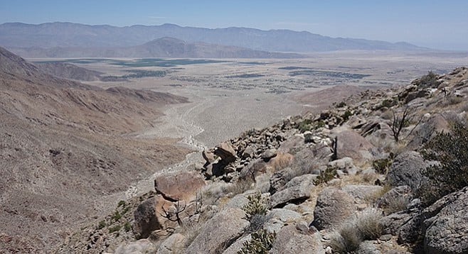
Hellhole Canyon above Culp Valley
The trail dips and climbs short stretches as it meanders over and around ravines and outcrops without losing significant elevation until a descent to Pena Spring. Approximately 0.7 mile from the start, the trail passes a small open galvanized watering tank on the left in vicinity of By Jim Spring. This tank and its associated pipes are in disrepair and typically dry. CRHT markers are frequently encountered along the upper portion including several of the original style wood posts. A nice view of distant Salton Sea is encountered 1 mile from the trailhead and the first sighting of the Santa Rosa Mountains to the northeast is at 1.3 miles.
At 2.5 miles, the trail descends steeply for 0.33 mile to the Pena Spring trailhead, the first good access to Hellhole Canyon. A small parking area is located to the right and several use trails lead to the spring on the left. This is an alternate starting point for a shorter hike or for exploring Pena Spring. Parking here is limited to four or possibly five vehicles. Pena Spring provides the only reliable water along this hike and is reached by following one of several short use trails branching off from the CRHT. Surrounded by riparian vegetation, it is easier to hear the spring than see where the water gurgles slowly out of a vertical pipe obscured by reeds. This is a good spot for birding and wildlife observation early in the morning or during evening twilight.
From the Pena Spring junction, the trail climbs again before leveling off as you approach a junction with the Culp Valley Trail at 3.5 miles. This accessible gravel path arcs 0.5 mile southward to Culp Valley Primitive Camp. Pit toilets are available but there is no water or other improvements. Situated 500 feet from the junction on the north side of the CRHT is a viewpoint called Scenic Overlook. From here you can look down Hellhole Canyon and across Borrego Valley to the Santa Rosa Mountains. The Culp Valley Primitive Camp trailhead is an alternate starting point for a 5-mile CRHT hike to the Hellhole trailhead and the one most commonly used.
From the Culp Valley Trail junction, the main trail starts a gentle climb before again leveling off and starting a long descent along the ridge between Hellhole Canyon and Dry Canyon. An optional side trip is a short ascent on an unmarked use trail departing on the right at 0.3 mile from Scenic Overlook. This path leads to another viewpoint called Culp Valley Lookout, the high point of a loop that returns you to the CRHT.
Another possible side-trip is an easy cross-country scramble to Lookout Point, departing the CRHT at one mile beyond the Culp Valley Trail junction. Follow the terrain to a ridge overlooking Hellhole Canyon just above Maidenhair Falls. You won’t be able to see the falls but you can look down on native Washingtonia palms that thrive in this part of Hellhole Canyon. Consider pausing here for lunch, where at an elevation of 3000 feet, it will be cooler than any point lower on the trail.
Now starts the primary downhill section dropping 2100 feet in the last 3 miles as the CRHT passes through the last of the junipers and transitions to the upper reaches of the Colorado Desert. The spare landscape features agave, ocotillo, prickly pear, barrel cactus, teddy bear cholla, springtime belly flowers, and the ubiquitous brittlebush. The CRHT markers are absent from this stretch, but the trail is well used and obvious. Temperatures can be quite high in the narrower ravines along this stretch, so make sure to carry and drink plenty of water.
One last side-trail branches from the CRHT one mile short of the end of the hike (7 miles from the Jasper starting point), where remnants of the original cattle trail can be followed to the right, eventually coming out at S-22 about 0.75 mile above the Hellhole Canyon parking area. A brown and yellow CRHT post marks this point. Looking out over the Borrego Valley, the ABDSP Visitor Center and Colorado Desert District Headquarters buildings are the closest structures seen from here.
After negotiating the last few switchbacks, the trail emerges into the flats of lower Hellhole Canyon. Turning left will lead into the canyon on the popular trail to Maidenhair Falls, a trip best saved for another visit. The parking area is 0.3 mile to the east.
CRHT TO ANZA-BORREGO’S HELLHOLE CANYON
Distance from downtown San Diego: 75 miles to the upper trailhead at Jasper Trail; 79 miles to the middle trailhead at Culp Valley Primitive Camp; 85 miles to the lower trailhead at the Hellhole Canyon parking area. Allow 1.5 to 2 hours driving time, depending on trailhead used (Anza-Borrego Desert State Park). From the junction of SR-67/78 in Ramona, drive east on SR-78, 27 miles to Santa Ysabel. Turn left (north) on SR-79 and drive 11 miles to the junction with S-2/San Felipe Rd., and turn right (southeast). Drive 4.5 miles on S-2 to the junction with S-22/Montezuma Highway and turn left (east). Drive 6.8 miles on S-22, 1.7 miles east of the Ranchita Store, to the upper trailhead on north side of S-22 across from the Jasper Trail sign. The Culp Valley trailhead departs from Culp Valley Primitive Camp, which is on the north side of S-22, 5.7 miles east of Ranchita and about 7 miles west of Borrego Springs. The lower trailhead at the entrance to Hellhole Canyon parking area is on the west side of S-22, 11.5 miles east of Ranchita and about 1 mile north of the junction with Palm Canyon Dr. in Borrego Springs.
Hiking length: 8 miles one-way from Jasper Trail, 5 miles one-way from Culp Valley Primitive Camp to lower Hellhole Canyon. Optional side trips to Pena Spring, Culp Valley Lookout (use trail) and Lookout Point (cross-country) will add an additional 1.5 to 2 miles.
Difficulty: Moderately strenuous with 500 feet of elevation gain and 3700 feet of elevation loss (over 1000 feet of elevation gain and 4200 feet of elevation loss with side trips). Facilities at Culp Valley Primitive Camp and lower Hellhole Canyon trailhead. No water available at the trailheads. Pena Spring is located off trail northeast of Culp Valley but should not be relied upon for water. Dogs and mountain bikes not allowed. If camping en route, bring a small stove for cooking. No open fires permitted at any time, except in Culp Valley Primitive Camp, where fires must be in a metal container.
Here's something you might be interested in.
Plenty of options on the trail to Hellhole Canyon
Trail options offer elevation loss up to 4000 feet through various life zones
Plenty of options on the trail to Hellhole Canyon
Trail options offer elevation loss up to 4000 feet through various life zones
Part of the trail to Lower Hellholle Canyon
This 8-mile spur of the California Riding and Hiking Trail (CRHT) rewards hikers with a variety of desert habitats, providing exceptional views of the San Ysidro Mountains, Borrego Valley, Santa Rosa Mountains, and Salton Sea. It follows a ridge route between Hellhole Canyon and Dry Canyon in Anza-Borrego Desert State Park (ABDSP). Added attractions are seasonal wildflower and cactus blossom displays, a host of native birds, and possible encounters with mule deer and bighorn sheep as you descend from high desert vegetation to the Colorado Desert floor.
Authorized by the California State Legislature in 1945, the CRHT was envisioned as a statewide recreational trail stretching from San Diego County to the Oregon border. Over 1000 miles of improved trail were constructed or adopted across the state, including 100 miles in San Diego County. Marked with signature brown fence posts capped with yellow paint, the CRHT has been largely abandoned or subsumed by newer trails, modern roads, or realignments due in part to funding cuts in the 1960s and private property access issues. Fortunately, a few stretches remain in nearly their original form.
Map to Lower Hellhole Canyon
This hike descends a spur segment that follows a prehistoric Native American pathway and a 20th-century cattle-drive route. The trip description is for a west-to-east descending hike starting near the junction of S-22 and the Jasper Trail. A small sign on the north side of S-22, across the highway from the larger Jasper Trail sign, marks the trailhead. Unfortunately, there is no parking area here but a turnout just to the west is available. For a one-way through hike, arrange a car shuttle from the Hellhole Canyon trailhead near Borrego Springs. Some hikers start from the bottom for a challenging variant, including a truly adventurous out-and-back of 16 miles round trip to reach the Jasper end or 10 miles out-and-back from Culp Valley. These options should be attempted during seasonally cooler months, as summer temperatures frequently reach 110 degrees or higher on the lower half of the trail.
Starting at an elevation of 4100 feet, the trail begins in chaparral mixed with desert species such as yucca, agave, beavertail cactus, and cat claw. Although infrequent, there can be snow at this elevation, as winter storms pass through the area. Mule deer, coyotes, and bobcats may be seen in the upper sections along with occasional tracks or scat left by the elusive mountain lion. Drought and recent fires in the area have thinned the vegetation and Mesozoic Era granite boulders are now more prominent. These exposed remnants of the batholith that rose up to form the Peninsular Range and current Sierra Nevada are testaments to the dynamic geology of our region.
Hellhole Canyon above Culp Valley
The trail dips and climbs short stretches as it meanders over and around ravines and outcrops without losing significant elevation until a descent to Pena Spring. Approximately 0.7 mile from the start, the trail passes a small open galvanized watering tank on the left in vicinity of By Jim Spring. This tank and its associated pipes are in disrepair and typically dry. CRHT markers are frequently encountered along the upper portion including several of the original style wood posts. A nice view of distant Salton Sea is encountered 1 mile from the trailhead and the first sighting of the Santa Rosa Mountains to the northeast is at 1.3 miles.
At 2.5 miles, the trail descends steeply for 0.33 mile to the Pena Spring trailhead, the first good access to Hellhole Canyon. A small parking area is located to the right and several use trails lead to the spring on the left. This is an alternate starting point for a shorter hike or for exploring Pena Spring. Parking here is limited to four or possibly five vehicles. Pena Spring provides the only reliable water along this hike and is reached by following one of several short use trails branching off from the CRHT. Surrounded by riparian vegetation, it is easier to hear the spring than see where the water gurgles slowly out of a vertical pipe obscured by reeds. This is a good spot for birding and wildlife observation early in the morning or during evening twilight.
From the Pena Spring junction, the trail climbs again before leveling off as you approach a junction with the Culp Valley Trail at 3.5 miles. This accessible gravel path arcs 0.5 mile southward to Culp Valley Primitive Camp. Pit toilets are available but there is no water or other improvements. Situated 500 feet from the junction on the north side of the CRHT is a viewpoint called Scenic Overlook. From here you can look down Hellhole Canyon and across Borrego Valley to the Santa Rosa Mountains. The Culp Valley Primitive Camp trailhead is an alternate starting point for a 5-mile CRHT hike to the Hellhole trailhead and the one most commonly used.
From the Culp Valley Trail junction, the main trail starts a gentle climb before again leveling off and starting a long descent along the ridge between Hellhole Canyon and Dry Canyon. An optional side trip is a short ascent on an unmarked use trail departing on the right at 0.3 mile from Scenic Overlook. This path leads to another viewpoint called Culp Valley Lookout, the high point of a loop that returns you to the CRHT.
Another possible side-trip is an easy cross-country scramble to Lookout Point, departing the CRHT at one mile beyond the Culp Valley Trail junction. Follow the terrain to a ridge overlooking Hellhole Canyon just above Maidenhair Falls. You won’t be able to see the falls but you can look down on native Washingtonia palms that thrive in this part of Hellhole Canyon. Consider pausing here for lunch, where at an elevation of 3000 feet, it will be cooler than any point lower on the trail.
Now starts the primary downhill section dropping 2100 feet in the last 3 miles as the CRHT passes through the last of the junipers and transitions to the upper reaches of the Colorado Desert. The spare landscape features agave, ocotillo, prickly pear, barrel cactus, teddy bear cholla, springtime belly flowers, and the ubiquitous brittlebush. The CRHT markers are absent from this stretch, but the trail is well used and obvious. Temperatures can be quite high in the narrower ravines along this stretch, so make sure to carry and drink plenty of water.
One last side-trail branches from the CRHT one mile short of the end of the hike (7 miles from the Jasper starting point), where remnants of the original cattle trail can be followed to the right, eventually coming out at S-22 about 0.75 mile above the Hellhole Canyon parking area. A brown and yellow CRHT post marks this point. Looking out over the Borrego Valley, the ABDSP Visitor Center and Colorado Desert District Headquarters buildings are the closest structures seen from here.
After negotiating the last few switchbacks, the trail emerges into the flats of lower Hellhole Canyon. Turning left will lead into the canyon on the popular trail to Maidenhair Falls, a trip best saved for another visit. The parking area is 0.3 mile to the east.
CRHT TO ANZA-BORREGO’S HELLHOLE CANYON
Distance from downtown San Diego: 75 miles to the upper trailhead at Jasper Trail; 79 miles to the middle trailhead at Culp Valley Primitive Camp; 85 miles to the lower trailhead at the Hellhole Canyon parking area. Allow 1.5 to 2 hours driving time, depending on trailhead used (Anza-Borrego Desert State Park). From the junction of SR-67/78 in Ramona, drive east on SR-78, 27 miles to Santa Ysabel. Turn left (north) on SR-79 and drive 11 miles to the junction with S-2/San Felipe Rd., and turn right (southeast). Drive 4.5 miles on S-2 to the junction with S-22/Montezuma Highway and turn left (east). Drive 6.8 miles on S-22, 1.7 miles east of the Ranchita Store, to the upper trailhead on north side of S-22 across from the Jasper Trail sign. The Culp Valley trailhead departs from Culp Valley Primitive Camp, which is on the north side of S-22, 5.7 miles east of Ranchita and about 7 miles west of Borrego Springs. The lower trailhead at the entrance to Hellhole Canyon parking area is on the west side of S-22, 11.5 miles east of Ranchita and about 1 mile north of the junction with Palm Canyon Dr. in Borrego Springs.
Hiking length: 8 miles one-way from Jasper Trail, 5 miles one-way from Culp Valley Primitive Camp to lower Hellhole Canyon. Optional side trips to Pena Spring, Culp Valley Lookout (use trail) and Lookout Point (cross-country) will add an additional 1.5 to 2 miles.
Difficulty: Moderately strenuous with 500 feet of elevation gain and 3700 feet of elevation loss (over 1000 feet of elevation gain and 4200 feet of elevation loss with side trips). Facilities at Culp Valley Primitive Camp and lower Hellhole Canyon trailhead. No water available at the trailheads. Pena Spring is located off trail northeast of Culp Valley but should not be relied upon for water. Dogs and mountain bikes not allowed. If camping en route, bring a small stove for cooking. No open fires permitted at any time, except in Culp Valley Primitive Camp, where fires must be in a metal container.
Comments