Here's something you might be interested in.
Ask a Hipster — Advice you didn't know you needed
Big Screen — Movie commentary
Blurt — Music's inside track
Booze News — San Diego spirits
Classical Music — Immortal beauty
Classifieds — Free and easy
Cover Stories — Front-page features
Drinks All Around — Bartenders' drink recipes
Excerpts — Literary and spiritual excerpts
Feast! — Food & drink reviews
Feature Stories — Local news & stories
Fishing Report — What’s getting hooked from ship and shore
From the Archives — Spotlight on the past
Golden Dreams — Talk of the town
The Gonzo Report — Making the musical scene, or at least reporting from it
Letters — Our inbox
Movies@Home — Local movie buffs share favorites
Movie Reviews — Our critics' picks and pans
Musician Interviews — Up close with local artists
Neighborhood News from Stringers — Hyperlocal news
News Ticker — News & politics
Obermeyer — San Diego politics illustrated
Outdoors — Weekly changes in flora and fauna
Overheard in San Diego — Eavesdropping illustrated
Poetry — The old and the new
Reader Travel — Travel section built by travelers
Reading — The hunt for intellectuals
Roam-O-Rama — SoCal's best hiking/biking trails
San Diego Beer — Inside San Diego suds
SD on the QT — Almost factual news
Sheep and Goats — Places of worship
Special Issues — The best of
Street Style — San Diego streets have style
Surf Diego — Real stories from those braving the waves
Theater — On stage in San Diego this week
Tin Fork — Silver spoon alternative
Under the Radar — Matt Potter's undercover work
Unforgettable — Long-ago San Diego
Unreal Estate — San Diego's priciest pads
Your Week — Daily event picks
Varied habitats, outstanding views
Add five strenuous miles to get to Potato Chip Rock.
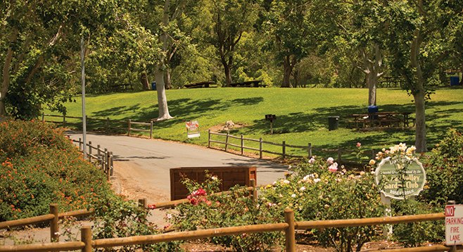
Many trails radiate from Lake Poway’s grassy, manicured core. This is the entrance.
The Lake Poway Recreational Area is a great place to enjoy favorite outdoor activities — from fishing, boating, camping, and picnicking to hiking on one of the many trails that radiate from its grassy, manicured core. The trail described here is a loop that not only goes around the lake but also passes through varied native habitats and offers outstanding views. The lake is a reservoir, holding drinking water for the City of Poway, and swimming is not permitted, but boating and fishing are.
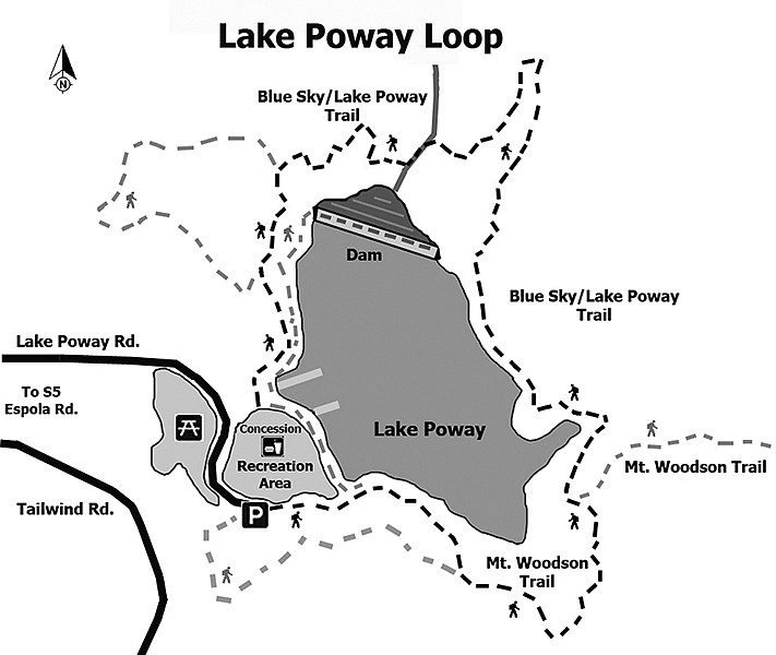
Ideally, leave your vehicle in the southeasterly most parking area to begin the hike, although it may be difficult to find an open parking spot on busy weekends. The Lake Poway trail begins at the southeast end of the parking area and continues in a counter-clockwise direction around the lake. The first trail segment is on a bluff overlooking the lake. It goes up a north-facing canyon through fairly dense chaparral, with laurel sumac, scrub oaks, a few coast live oaks, mission manzanita, and broom baccharis. Wildflowers may include California poppy, cream cups, white sage, sun cups, and caterpillar phacelia in season.
After about half a mile, the trail makes a nearly 90-degree turn toward the north and continues along the eastern side of the lake. This southwest-facing slope receives more direct sunlight and is hotter and dryer as a result. The vegetation here is typical of sage scrub, with abundant California sagebrush, flattop buckwheat, black sage, golden yarrow, California matchweed, telegraph weed, and San Diego goldenbush. At slightly less than a mile into the hike, the trail forks. Keep to the left to continue your hike around the lake but avoid descending to the shoreline fisherman’s trail, which is not continuous. The right branch leads up to Potato Chip Rock and the top of Mt. Woodson, which you could explore, but it will add about 5 strenuous miles to the hike.
The Lake Poway Loop trail rises progressing northwest toward the dam, cresting as it rounds the restricted area near the dam. It then descends through a series of switchbacks to the canyon bottom near the foot of the dam. The trail again forks. The trail to the left will go back up the hillside on the west side of the dam and on to the recreation area’s concession stands, not far from the parking area. Before returning to the parking area, however, take a short hike down the trail on the right, heading to Blue Sky Reserve. The Lake Poway Campground and Picnic Area is about 0.10 mile down this path. Camping is no longer allowed and it is now strictly a day-use area. However, it offers cool shade among coast live oaks, as well as picnic tables, drinking water, restroom facilities, and is a good place to rest before the climb up the hill to get back to your vehicle.
- Distance from downtown San Diego: About 30 miles. Allow 30 minutes (Poway). Take CA-163N and I-15N, exiting on Rancho Bernardo Rd. Go east on Rancho Bernardo Road, which becomes Espola Road when it enters Poway. Approximately 4.5 miles from I-15, make a left on Lake Poway Rd. The recreation area parking lot is at the end of Lake Poway Rd., in less than a mile. Parking is free for Poway residents and for everyone on weekdays, but there is an $8 charge for non-resident parking on weekends. It is open from 6 a.m. to dusk daily.
- Hiking length: 2.7-mile loop. Allow 1.5 hours.
- Difficulty: Moderately strenuous with a few steep sections, despite long stretches of relatively flat trails. Carry water, as much of the trail offers no relief from the sun on hot days. Trails are open to hikers, mountain bikers, equestrians, and leashed dogs. Full facilities including a snack bar in the landscaped park area. Porta-potties are also found along the trail but not water.
Here's something you might be interested in.
Varied habitats, outstanding views
Add five strenuous miles to get to Potato Chip Rock.
Varied habitats, outstanding views
Add five strenuous miles to get to Potato Chip Rock.
Many trails radiate from Lake Poway’s grassy, manicured core. This is the entrance.
The Lake Poway Recreational Area is a great place to enjoy favorite outdoor activities — from fishing, boating, camping, and picnicking to hiking on one of the many trails that radiate from its grassy, manicured core. The trail described here is a loop that not only goes around the lake but also passes through varied native habitats and offers outstanding views. The lake is a reservoir, holding drinking water for the City of Poway, and swimming is not permitted, but boating and fishing are.
Ideally, leave your vehicle in the southeasterly most parking area to begin the hike, although it may be difficult to find an open parking spot on busy weekends. The Lake Poway trail begins at the southeast end of the parking area and continues in a counter-clockwise direction around the lake. The first trail segment is on a bluff overlooking the lake. It goes up a north-facing canyon through fairly dense chaparral, with laurel sumac, scrub oaks, a few coast live oaks, mission manzanita, and broom baccharis. Wildflowers may include California poppy, cream cups, white sage, sun cups, and caterpillar phacelia in season.
After about half a mile, the trail makes a nearly 90-degree turn toward the north and continues along the eastern side of the lake. This southwest-facing slope receives more direct sunlight and is hotter and dryer as a result. The vegetation here is typical of sage scrub, with abundant California sagebrush, flattop buckwheat, black sage, golden yarrow, California matchweed, telegraph weed, and San Diego goldenbush. At slightly less than a mile into the hike, the trail forks. Keep to the left to continue your hike around the lake but avoid descending to the shoreline fisherman’s trail, which is not continuous. The right branch leads up to Potato Chip Rock and the top of Mt. Woodson, which you could explore, but it will add about 5 strenuous miles to the hike.
The Lake Poway Loop trail rises progressing northwest toward the dam, cresting as it rounds the restricted area near the dam. It then descends through a series of switchbacks to the canyon bottom near the foot of the dam. The trail again forks. The trail to the left will go back up the hillside on the west side of the dam and on to the recreation area’s concession stands, not far from the parking area. Before returning to the parking area, however, take a short hike down the trail on the right, heading to Blue Sky Reserve. The Lake Poway Campground and Picnic Area is about 0.10 mile down this path. Camping is no longer allowed and it is now strictly a day-use area. However, it offers cool shade among coast live oaks, as well as picnic tables, drinking water, restroom facilities, and is a good place to rest before the climb up the hill to get back to your vehicle.
- Distance from downtown San Diego: About 30 miles. Allow 30 minutes (Poway). Take CA-163N and I-15N, exiting on Rancho Bernardo Rd. Go east on Rancho Bernardo Road, which becomes Espola Road when it enters Poway. Approximately 4.5 miles from I-15, make a left on Lake Poway Rd. The recreation area parking lot is at the end of Lake Poway Rd., in less than a mile. Parking is free for Poway residents and for everyone on weekdays, but there is an $8 charge for non-resident parking on weekends. It is open from 6 a.m. to dusk daily.
- Hiking length: 2.7-mile loop. Allow 1.5 hours.
- Difficulty: Moderately strenuous with a few steep sections, despite long stretches of relatively flat trails. Carry water, as much of the trail offers no relief from the sun on hot days. Trails are open to hikers, mountain bikers, equestrians, and leashed dogs. Full facilities including a snack bar in the landscaped park area. Porta-potties are also found along the trail but not water.