Here's something you might be interested in.
Ask a Hipster — Advice you didn't know you needed
Big Screen — Movie commentary
Blurt — Music's inside track
Booze News — San Diego spirits
Classical Music — Immortal beauty
Classifieds — Free and easy
Cover Stories — Front-page features
Drinks All Around — Bartenders' drink recipes
Excerpts — Literary and spiritual excerpts
Feast! — Food & drink reviews
Feature Stories — Local news & stories
Fishing Report — What’s getting hooked from ship and shore
From the Archives — Spotlight on the past
Golden Dreams — Talk of the town
The Gonzo Report — Making the musical scene, or at least reporting from it
Letters — Our inbox
Movies@Home — Local movie buffs share favorites
Movie Reviews — Our critics' picks and pans
Musician Interviews — Up close with local artists
Neighborhood News from Stringers — Hyperlocal news
News Ticker — News & politics
Obermeyer — San Diego politics illustrated
Outdoors — Weekly changes in flora and fauna
Overheard in San Diego — Eavesdropping illustrated
Poetry — The old and the new
Reader Travel — Travel section built by travelers
Reading — The hunt for intellectuals
Roam-O-Rama — SoCal's best hiking/biking trails
San Diego Beer — Inside San Diego suds
SD on the QT — Almost factual news
Sheep and Goats — Places of worship
Special Issues — The best of
Street Style — San Diego streets have style
Surf Diego — Real stories from those braving the waves
Theater — On stage in San Diego this week
Tin Fork — Silver spoon alternative
Under the Radar — Matt Potter's undercover work
Unforgettable — Long-ago San Diego
Unreal Estate — San Diego's priciest pads
Your Week — Daily event picks
Crushed seashells + limestone + Kumeyaay “laborers” = the Mission Dam
Get a close up view of rugged Mission Gorge and a national historic landmark.
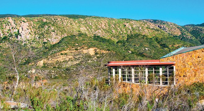
Mission Trails Visitor Center with Kwaay Paay summit in the background.
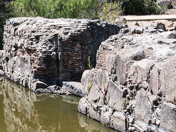
Brick and rock work are visible at the dam site.
This hike goes through scenic Mission Gorge and leads to the Old Mission Dam that impounded the San Diego River to provide water for the Spanish Mission San Diego de Alcalá. The dam is a nationally registered historic landmark and is composed of large boulders and adobe bricks and tiles that have been cemented together with crushed seashells and limestone. It was an impressive engineering feat in its day, given its size and the tools they had to construct it. Construction took six years, between 1809 and 1815, and was done by Kumeyaay laborers with hand tools, working under the direction of the padres. An aqueduct was completed at the same time to carry the water six miles from the dam to the mission.
Begin the hike from the Visitor Center and head toward Father Junipero Serra Trail (FJST). Just before reaching FJST is a sign for the Visitor Center Loop Trail. This is the first possibility for extending the length of the hike by 1.4 miles to follow this loop trail down near the San Diego River and through the shade of the dense riparian growth along the river. If not interested in extending the trip here, just continue to the FJST and go left.
The right side of the FJST is a 15 mph, one-way vehicular road that parallels the San Diego River as it makes its way through Mission Gorge. One could drive their vehicle the 1.6 miles to the Old Mission Dam parking lot from the visitors’ center. However, if you do, you will miss many of the sights and sounds of this remarkable rugged canyon. The left side of the FJST is reserved for pedestrians and bicyclists. Use it as your path to the dam. Dogs on leashes are allowed on the FJST.
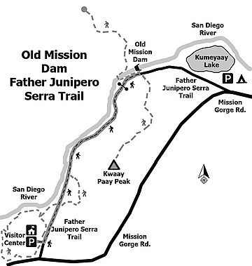
About a half a mile after leaving the visitors’ center on the FJST, there is another opportunity to take a brief side excursion by following the trail marked “Grinding Rocks Trail” on the left. The trail leads to a place where the Kumeyaay people used grinding rocks (morteros) to prepare acorns for food. These pitted boulders remain as evidence of their life and long presence in this area. On the right side of the FJST, at nearly the same point where the Grinding Trail departs, is the beginning of the Climber’s Trail. It is another loop trail, one mile in length, that goes several hundred feet above the FJST to the base of some huge boulders that provide one of the best rock-climbing locations in San Diego County. Even if not interested in rock climbing, the views from this loop trail and out to the city are worth the extra effort.
Even if not taking one or more of the optional detours going up the FJST, take time to examine the diverse vegetation beside the trail. This includes typical chaparral and sage-scrub plants such as mission manzanita, black sage, California lilac, fuchsia-flowered gooseberry, buckwheat, chaparral yucca, lemonade berry, and many others. A full-color guide to the “Flowering Plants of Mission Trails Regional Park” is available at the visitors’ center to help identify the many plants.
At mile 1.6 from the turnout to the visitors’ center is the parking area for the Old Mission Dam and the short trail leading to the dam. After exploring this engineering marvel, consider continuing the hike up the Oak Canyon Trail. This area was devastated by the 2003 Cedar Fire, but the willows, mule fat, oaks, cottonwoods, and sycamore trees that line the canyon have made an almost complete recovery. However, because of the drought this year, there won’t be flowing water in this canyon.
- Distance from downtown San Diego: 12 miles. Allow 20 minutes (San Carlos). From CA-163N, merge onto I-8E, then take the Mission Gorge Road exit and go 4.3 miles northeast on Mission Gorge Road. Turn left onto Father Junipero Serra Trail at a large wooden sign for Mission Trails Regional Park. Continue a short distance, following the signs to the visitors’ center parking lot. There is no charge for parking or for day-use of Mission Trails Regional Park.
- Hiking length: 5 miles out and back with numerous opportunities to expand or contract the hike.
- Difficulty: Easy, 50 feet elevation gain/loss, most of which would be accessible to everyone. Facilities are available at the visitors’ center, an architecturally striking building with interesting and unusual exhibits. Carry at least a liter of drinking water.
Here's something you might be interested in.
Crushed seashells + limestone + Kumeyaay “laborers” = the Mission Dam
Get a close up view of rugged Mission Gorge and a national historic landmark.
Crushed seashells + limestone + Kumeyaay “laborers” = the Mission Dam
Get a close up view of rugged Mission Gorge and a national historic landmark.
Mission Trails Visitor Center with Kwaay Paay summit in the background.
Brick and rock work are visible at the dam site.
This hike goes through scenic Mission Gorge and leads to the Old Mission Dam that impounded the San Diego River to provide water for the Spanish Mission San Diego de Alcalá. The dam is a nationally registered historic landmark and is composed of large boulders and adobe bricks and tiles that have been cemented together with crushed seashells and limestone. It was an impressive engineering feat in its day, given its size and the tools they had to construct it. Construction took six years, between 1809 and 1815, and was done by Kumeyaay laborers with hand tools, working under the direction of the padres. An aqueduct was completed at the same time to carry the water six miles from the dam to the mission.
Begin the hike from the Visitor Center and head toward Father Junipero Serra Trail (FJST). Just before reaching FJST is a sign for the Visitor Center Loop Trail. This is the first possibility for extending the length of the hike by 1.4 miles to follow this loop trail down near the San Diego River and through the shade of the dense riparian growth along the river. If not interested in extending the trip here, just continue to the FJST and go left.
The right side of the FJST is a 15 mph, one-way vehicular road that parallels the San Diego River as it makes its way through Mission Gorge. One could drive their vehicle the 1.6 miles to the Old Mission Dam parking lot from the visitors’ center. However, if you do, you will miss many of the sights and sounds of this remarkable rugged canyon. The left side of the FJST is reserved for pedestrians and bicyclists. Use it as your path to the dam. Dogs on leashes are allowed on the FJST.
About a half a mile after leaving the visitors’ center on the FJST, there is another opportunity to take a brief side excursion by following the trail marked “Grinding Rocks Trail” on the left. The trail leads to a place where the Kumeyaay people used grinding rocks (morteros) to prepare acorns for food. These pitted boulders remain as evidence of their life and long presence in this area. On the right side of the FJST, at nearly the same point where the Grinding Trail departs, is the beginning of the Climber’s Trail. It is another loop trail, one mile in length, that goes several hundred feet above the FJST to the base of some huge boulders that provide one of the best rock-climbing locations in San Diego County. Even if not interested in rock climbing, the views from this loop trail and out to the city are worth the extra effort.
Even if not taking one or more of the optional detours going up the FJST, take time to examine the diverse vegetation beside the trail. This includes typical chaparral and sage-scrub plants such as mission manzanita, black sage, California lilac, fuchsia-flowered gooseberry, buckwheat, chaparral yucca, lemonade berry, and many others. A full-color guide to the “Flowering Plants of Mission Trails Regional Park” is available at the visitors’ center to help identify the many plants.
At mile 1.6 from the turnout to the visitors’ center is the parking area for the Old Mission Dam and the short trail leading to the dam. After exploring this engineering marvel, consider continuing the hike up the Oak Canyon Trail. This area was devastated by the 2003 Cedar Fire, but the willows, mule fat, oaks, cottonwoods, and sycamore trees that line the canyon have made an almost complete recovery. However, because of the drought this year, there won’t be flowing water in this canyon.
- Distance from downtown San Diego: 12 miles. Allow 20 minutes (San Carlos). From CA-163N, merge onto I-8E, then take the Mission Gorge Road exit and go 4.3 miles northeast on Mission Gorge Road. Turn left onto Father Junipero Serra Trail at a large wooden sign for Mission Trails Regional Park. Continue a short distance, following the signs to the visitors’ center parking lot. There is no charge for parking or for day-use of Mission Trails Regional Park.
- Hiking length: 5 miles out and back with numerous opportunities to expand or contract the hike.
- Difficulty: Easy, 50 feet elevation gain/loss, most of which would be accessible to everyone. Facilities are available at the visitors’ center, an architecturally striking building with interesting and unusual exhibits. Carry at least a liter of drinking water.