Here's something you might be interested in.
Ask a Hipster — Advice you didn't know you needed
Big Screen — Movie commentary
Blurt — Music's inside track
Booze News — San Diego spirits
Classical Music — Immortal beauty
Classifieds — Free and easy
Cover Stories — Front-page features
Drinks All Around — Bartenders' drink recipes
Excerpts — Literary and spiritual excerpts
Feast! — Food & drink reviews
Feature Stories — Local news & stories
Fishing Report — What’s getting hooked from ship and shore
From the Archives — Spotlight on the past
Golden Dreams — Talk of the town
The Gonzo Report — Making the musical scene, or at least reporting from it
Letters — Our inbox
Movies@Home — Local movie buffs share favorites
Movie Reviews — Our critics' picks and pans
Musician Interviews — Up close with local artists
Neighborhood News from Stringers — Hyperlocal news
News Ticker — News & politics
Obermeyer — San Diego politics illustrated
Outdoors — Weekly changes in flora and fauna
Overheard in San Diego — Eavesdropping illustrated
Poetry — The old and the new
Reader Travel — Travel section built by travelers
Reading — The hunt for intellectuals
Roam-O-Rama — SoCal's best hiking/biking trails
San Diego Beer — Inside San Diego suds
SD on the QT — Almost factual news
Sheep and Goats — Places of worship
Special Issues — The best of
Street Style — San Diego streets have style
Surf Diego — Real stories from those braving the waves
Theater — On stage in San Diego this week
Tin Fork — Silver spoon alternative
Under the Radar — Matt Potter's undercover work
Unforgettable — Long-ago San Diego
Unreal Estate — San Diego's priciest pads
Your Week — Daily event picks
Kwaay Paay Peak, Mission Trails Regional Park
Get a good workout and avoid the crowd on Cowles Mountain
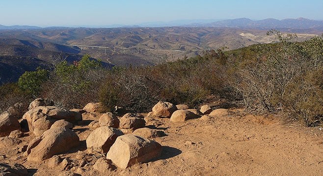
Kwaay Paay Peak’s vigorous hike, great views, and lack of crowds make it a welcome alternative to its Mission Trails neighbor, Cowles Mountain.
Kwaay Paay Peak is a good alternative to Cowles Mountain for anyone who wants a good climbing hike without a crowd. It is the fourth highest peak in Mission Trails Regional Park, at an elevation of 1194 feet. The name of the peak is from the local Kumeyaay Indian word referring to a leader, and a leader it is, in terms of its difficulty because of the vertical climb and elevation gain. The top of the peak is a large level area with many flat-topped rocks that allow one to rest and take in the panoramic view extending out to Miramar, Point Loma, and Coronado. Santee and La Mesa are below the peak.
There are two trails leading from Father Junípero Serra Trail. The recommended route begins across from the Mission Dam parking area (the Mission Dam entrance) and ends at the other trailhead on Father Junípero Serra Trail, 0.2 mile east, across from the entrance to the Kumeyaay Lake and Campground, which is known as the Bushy Hill entrance. The Mission Dam route is less steep and merges with the Bushy Hill trail at mile 0.7. At this point, there is a single trail to the peak. In addition to the Mission Dam route and the Bushy Hill Trail, there is the option of following a third trail back to Father Juñipero Serra Trail. Continuing on, the trail to the peak passes through some sage scrub and grassland habitats and continues to the peak through typical chaparral. Plants encountered en route to the peak include laurel sumac, chamise, California lilac, buckwheat, chaparral broom, sugar bush, black sage, nolina, and manzanita.
At mile 1.26, the steep trail reaches a small flat crest where there is a view of the gorge dropping down toward the visitor center. Two peaks are visible from here, as is the trail that heads straight up. Kwaay Paay is the second peak.
Now begins the really steep part that does not level off until mile 1.65. The return through this section is challenging and this is where trekking poles really make a difference. The peak is only 0.15 mile ahead from this point. After enjoying the views, head back down to the trail junction at mile 2.6.
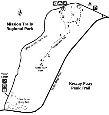
There are three options at the trail junction. The trail to the left is the trail back down to Mission Dam. The middle trail is the signed Bushy Hill trail. The trail to the right is signed the Canyon and Lake Trail, which also leads back to the Bushy Hill entrance, but it is more interesting. Go right. The trail immediately heads down into the canyon and over a bridge. It climbs a small ridge and heads to a housing area, following a fence down to the junction with the Bushy Hill trail at mile 3.4. This route follows drainage where there are riparian plants such as mule fat, willow, sycamores, and oak. Note the mistletoe on the sycamores. Grasslands are found above the riparian area. The trail ends at Father Junípero Serra Trail.
- Distance from downtown San Diego: 18 miles. Allow about 23 minutes. Drive north about 9 miles on SR-163 and turn east on SR-52. Drive 6.5 miles and exit on Mast Blvd., turning left under the freeway and then right on West Hills Parkway. Drive 0.7 mile to Mission Gorge Road and turn right. Proceed 0.3 mile on Mission Gorge Road and then turn right again on Father Junípero Serra Trail. At 0.2 mile, there is a dirt parking lot on the corner of Father Junípero Serra Trail and Bushy Hill. The trailhead is 0.2 mile further, past the entrance to the park and to Kumeyaay Lake and Campground, on the south side of Father Junípero Serra Trail. There is also a small parking area at the trailhead, which fills quickly, and some parking along the road. There are facilities in the campground and a chemical toilet at the small parking area across from the trailhead. If parking within the entrance gate, be sure to exit with your car before the gate is locked. Closure hours are posted and vary seasonally.
- Hiking length: 3.4 miles for recommended route — round trip.
- Difficulty: Moderately strenuous because of its steepness. Elevation gain of 817 feet. Trekking poles and hiking boots with good tread are recommended. There are no switchbacks and the trail down is steep. Carry water. Leashed dogs allowed on the trail but no mountain bikes.
Here's something you might be interested in.
Kwaay Paay Peak, Mission Trails Regional Park
Get a good workout and avoid the crowd on Cowles Mountain
Kwaay Paay Peak, Mission Trails Regional Park
Get a good workout and avoid the crowd on Cowles Mountain
Kwaay Paay Peak’s vigorous hike, great views, and lack of crowds make it a welcome alternative to its Mission Trails neighbor, Cowles Mountain.
Kwaay Paay Peak is a good alternative to Cowles Mountain for anyone who wants a good climbing hike without a crowd. It is the fourth highest peak in Mission Trails Regional Park, at an elevation of 1194 feet. The name of the peak is from the local Kumeyaay Indian word referring to a leader, and a leader it is, in terms of its difficulty because of the vertical climb and elevation gain. The top of the peak is a large level area with many flat-topped rocks that allow one to rest and take in the panoramic view extending out to Miramar, Point Loma, and Coronado. Santee and La Mesa are below the peak.
There are two trails leading from Father Junípero Serra Trail. The recommended route begins across from the Mission Dam parking area (the Mission Dam entrance) and ends at the other trailhead on Father Junípero Serra Trail, 0.2 mile east, across from the entrance to the Kumeyaay Lake and Campground, which is known as the Bushy Hill entrance. The Mission Dam route is less steep and merges with the Bushy Hill trail at mile 0.7. At this point, there is a single trail to the peak. In addition to the Mission Dam route and the Bushy Hill Trail, there is the option of following a third trail back to Father Juñipero Serra Trail. Continuing on, the trail to the peak passes through some sage scrub and grassland habitats and continues to the peak through typical chaparral. Plants encountered en route to the peak include laurel sumac, chamise, California lilac, buckwheat, chaparral broom, sugar bush, black sage, nolina, and manzanita.
At mile 1.26, the steep trail reaches a small flat crest where there is a view of the gorge dropping down toward the visitor center. Two peaks are visible from here, as is the trail that heads straight up. Kwaay Paay is the second peak.
Now begins the really steep part that does not level off until mile 1.65. The return through this section is challenging and this is where trekking poles really make a difference. The peak is only 0.15 mile ahead from this point. After enjoying the views, head back down to the trail junction at mile 2.6.
There are three options at the trail junction. The trail to the left is the trail back down to Mission Dam. The middle trail is the signed Bushy Hill trail. The trail to the right is signed the Canyon and Lake Trail, which also leads back to the Bushy Hill entrance, but it is more interesting. Go right. The trail immediately heads down into the canyon and over a bridge. It climbs a small ridge and heads to a housing area, following a fence down to the junction with the Bushy Hill trail at mile 3.4. This route follows drainage where there are riparian plants such as mule fat, willow, sycamores, and oak. Note the mistletoe on the sycamores. Grasslands are found above the riparian area. The trail ends at Father Junípero Serra Trail.
- Distance from downtown San Diego: 18 miles. Allow about 23 minutes. Drive north about 9 miles on SR-163 and turn east on SR-52. Drive 6.5 miles and exit on Mast Blvd., turning left under the freeway and then right on West Hills Parkway. Drive 0.7 mile to Mission Gorge Road and turn right. Proceed 0.3 mile on Mission Gorge Road and then turn right again on Father Junípero Serra Trail. At 0.2 mile, there is a dirt parking lot on the corner of Father Junípero Serra Trail and Bushy Hill. The trailhead is 0.2 mile further, past the entrance to the park and to Kumeyaay Lake and Campground, on the south side of Father Junípero Serra Trail. There is also a small parking area at the trailhead, which fills quickly, and some parking along the road. There are facilities in the campground and a chemical toilet at the small parking area across from the trailhead. If parking within the entrance gate, be sure to exit with your car before the gate is locked. Closure hours are posted and vary seasonally.
- Hiking length: 3.4 miles for recommended route — round trip.
- Difficulty: Moderately strenuous because of its steepness. Elevation gain of 817 feet. Trekking poles and hiking boots with good tread are recommended. There are no switchbacks and the trail down is steep. Carry water. Leashed dogs allowed on the trail but no mountain bikes.