Here's something you might be interested in.
Ask a Hipster — Advice you didn't know you needed
Big Screen — Movie commentary
Blurt — Music's inside track
Booze News — San Diego spirits
Classical Music — Immortal beauty
Classifieds — Free and easy
Cover Stories — Front-page features
Drinks All Around — Bartenders' drink recipes
Excerpts — Literary and spiritual excerpts
Feast! — Food & drink reviews
Feature Stories — Local news & stories
Fishing Report — What’s getting hooked from ship and shore
From the Archives — Spotlight on the past
Golden Dreams — Talk of the town
The Gonzo Report — Making the musical scene, or at least reporting from it
Letters — Our inbox
Movies@Home — Local movie buffs share favorites
Movie Reviews — Our critics' picks and pans
Musician Interviews — Up close with local artists
Neighborhood News from Stringers — Hyperlocal news
News Ticker — News & politics
Obermeyer — San Diego politics illustrated
Outdoors — Weekly changes in flora and fauna
Overheard in San Diego — Eavesdropping illustrated
Poetry — The old and the new
Reader Travel — Travel section built by travelers
Reading — The hunt for intellectuals
Roam-O-Rama — SoCal's best hiking/biking trails
San Diego Beer — Inside San Diego suds
SD on the QT — Almost factual news
Sheep and Goats — Places of worship
Special Issues — The best of
Street Style — San Diego streets have style
Surf Diego — Real stories from those braving the waves
Theater — On stage in San Diego this week
Tin Fork — Silver spoon alternative
Under the Radar — Matt Potter's undercover work
Unforgettable — Long-ago San Diego
Unreal Estate — San Diego's priciest pads
Your Week — Daily event picks
Noble Canyon
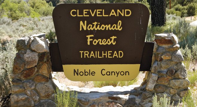
Noble Canyon trailhead
About 200 yards from the east side of the Penny Pines parking area is a view overlooking the Anza-Borrego Desert. Take a look before you enter the forest canopy. The Noble Canyon hike begins in an alpine forest and descends to an open chaparral and has water crossings and a variety of rocky landscapes and open views. Oak-lined trails along mountain cliffs are another highlight hiking through the Laguna Mountains in this southern section of the Cleveland National Forest. It is worth going the distance to experience the variety found on this trail.
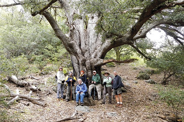
Immediately upon entering the top of the trail at Penny Pines, hikers are surrounded by a dense forest of canyon or maul oaks. Some of these trees may be over 300 years old, with canopies that spread for 100 feet. Interspersed among the forest trees, look for some rare plant finds, including fairy lanterns or globe lily, stream orchids, Humboldt or leopard lilies, and golden-bowl Mariposa lilies. The Humboldt lilies bloom soon after Memorial Day. Farther down the trail is showy penstemon and mountain blue curls.
Note the vegetation changes as you descend. After leaving the dense forest and riparian section, the trail opens to an arid desert of sage scrub with chaparral yucca and various species of cactus. Within the last mile of the trail you will enter a section of ribbonwood or red shank. At first glance you might think you have found another species of manzanita, given the red bark, but this is a cousin of the nearby chamise. Both are in the rose family.
The route crosses Pine Creek Road a couple of times during the descent as you head down to the Indian Creek Trail junction. The area burned in the 2003 Cedar Fire but is recovering well. Along the trail there is evidence of mining activity and the remnants of a homestead. Look for an abandoned mine shaft with the tailings spread around the opening.
Along the trail, be alert to the sounds and sights of many bird species. One of the more brightly colored ones will be the western tanager with his red head, yellow breast and black wings. As showy as his coloring is, he can easily disappear into the dense foliage. Also be alert for mountain-bikers on the trail.
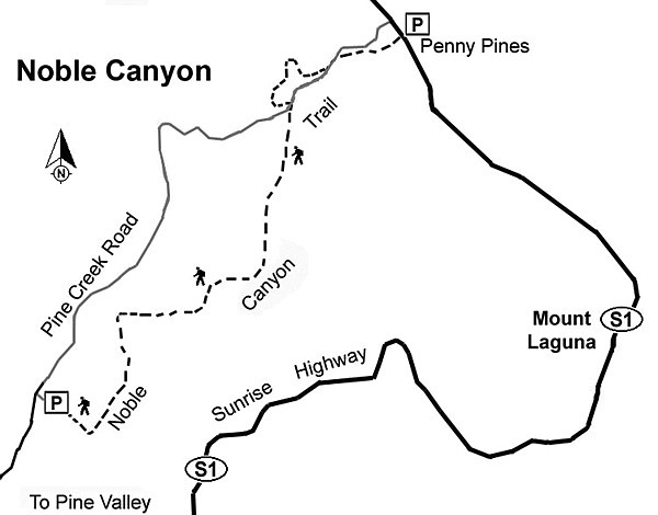
Distance from downtown San Diego: 49 miles to the Pine Creek Trailhead (Cleveland National Forest). Allow 55 minutes. From I-8 east, exit Pine Valley Rd. and head north. Turn west (left) on Old Hwy 80 and then north (right), directly past the bridge at Pine Creek Rd. Follow Pine Creek Rd. about 1.8 miles to the Cleveland National Forest trailhead sign. Park one vehicle here and shuttle hikers to the trailhead at Penny Pines at mile marker 27.3 on the Sunrise Highway (S-1), about 13 miles from the Pine Creek Trailhead. Restroom available. With the shuttle, allow a total of 1.5 hours of driving time. A National Forest Adventure Pass or Golden Age Passport must be displayed on parked vehicles at the trailheads.
Hiking length: 7.8 miles from the Penny Pines Trailhead back down to the parking area at Pine Creek. Allow 6 hours for the hike and for exploration of the trail. Difficulty: Strenuous due to the length of the hike. Elevation gain of 1165 feet and a descent of 2641 feet , with an overall net loss of nearly 1500 feet. Carry plenty of water. The best times to hike are from October through May.
Here's something you might be interested in.
Noble Canyon
Noble Canyon
Noble Canyon trailhead
About 200 yards from the east side of the Penny Pines parking area is a view overlooking the Anza-Borrego Desert. Take a look before you enter the forest canopy. The Noble Canyon hike begins in an alpine forest and descends to an open chaparral and has water crossings and a variety of rocky landscapes and open views. Oak-lined trails along mountain cliffs are another highlight hiking through the Laguna Mountains in this southern section of the Cleveland National Forest. It is worth going the distance to experience the variety found on this trail.
Immediately upon entering the top of the trail at Penny Pines, hikers are surrounded by a dense forest of canyon or maul oaks. Some of these trees may be over 300 years old, with canopies that spread for 100 feet. Interspersed among the forest trees, look for some rare plant finds, including fairy lanterns or globe lily, stream orchids, Humboldt or leopard lilies, and golden-bowl Mariposa lilies. The Humboldt lilies bloom soon after Memorial Day. Farther down the trail is showy penstemon and mountain blue curls.
Note the vegetation changes as you descend. After leaving the dense forest and riparian section, the trail opens to an arid desert of sage scrub with chaparral yucca and various species of cactus. Within the last mile of the trail you will enter a section of ribbonwood or red shank. At first glance you might think you have found another species of manzanita, given the red bark, but this is a cousin of the nearby chamise. Both are in the rose family.
The route crosses Pine Creek Road a couple of times during the descent as you head down to the Indian Creek Trail junction. The area burned in the 2003 Cedar Fire but is recovering well. Along the trail there is evidence of mining activity and the remnants of a homestead. Look for an abandoned mine shaft with the tailings spread around the opening.
Along the trail, be alert to the sounds and sights of many bird species. One of the more brightly colored ones will be the western tanager with his red head, yellow breast and black wings. As showy as his coloring is, he can easily disappear into the dense foliage. Also be alert for mountain-bikers on the trail.
Distance from downtown San Diego: 49 miles to the Pine Creek Trailhead (Cleveland National Forest). Allow 55 minutes. From I-8 east, exit Pine Valley Rd. and head north. Turn west (left) on Old Hwy 80 and then north (right), directly past the bridge at Pine Creek Rd. Follow Pine Creek Rd. about 1.8 miles to the Cleveland National Forest trailhead sign. Park one vehicle here and shuttle hikers to the trailhead at Penny Pines at mile marker 27.3 on the Sunrise Highway (S-1), about 13 miles from the Pine Creek Trailhead. Restroom available. With the shuttle, allow a total of 1.5 hours of driving time. A National Forest Adventure Pass or Golden Age Passport must be displayed on parked vehicles at the trailheads.
Hiking length: 7.8 miles from the Penny Pines Trailhead back down to the parking area at Pine Creek. Allow 6 hours for the hike and for exploration of the trail. Difficulty: Strenuous due to the length of the hike. Elevation gain of 1165 feet and a descent of 2641 feet , with an overall net loss of nearly 1500 feet. Carry plenty of water. The best times to hike are from October through May.
Comments