Here's something you might be interested in.
Ask a Hipster — Advice you didn't know you needed
Big Screen — Movie commentary
Blurt — Music's inside track
Booze News — San Diego spirits
Classical Music — Immortal beauty
Classifieds — Free and easy
Cover Stories — Front-page features
Drinks All Around — Bartenders' drink recipes
Excerpts — Literary and spiritual excerpts
Feast! — Food & drink reviews
Feature Stories — Local news & stories
Fishing Report — What’s getting hooked from ship and shore
From the Archives — Spotlight on the past
Golden Dreams — Talk of the town
The Gonzo Report — Making the musical scene, or at least reporting from it
Letters — Our inbox
Movies@Home — Local movie buffs share favorites
Movie Reviews — Our critics' picks and pans
Musician Interviews — Up close with local artists
Neighborhood News from Stringers — Hyperlocal news
News Ticker — News & politics
Obermeyer — San Diego politics illustrated
Outdoors — Weekly changes in flora and fauna
Overheard in San Diego — Eavesdropping illustrated
Poetry — The old and the new
Reader Travel — Travel section built by travelers
Reading — The hunt for intellectuals
Roam-O-Rama — SoCal's best hiking/biking trails
San Diego Beer — Inside San Diego suds
SD on the QT — Almost factual news
Sheep and Goats — Places of worship
Special Issues — The best of
Street Style — San Diego streets have style
Surf Diego — Real stories from those braving the waves
Theater — On stage in San Diego this week
Tin Fork — Silver spoon alternative
Under the Radar — Matt Potter's undercover work
Unforgettable — Long-ago San Diego
Unreal Estate — San Diego's priciest pads
Your Week — Daily event picks
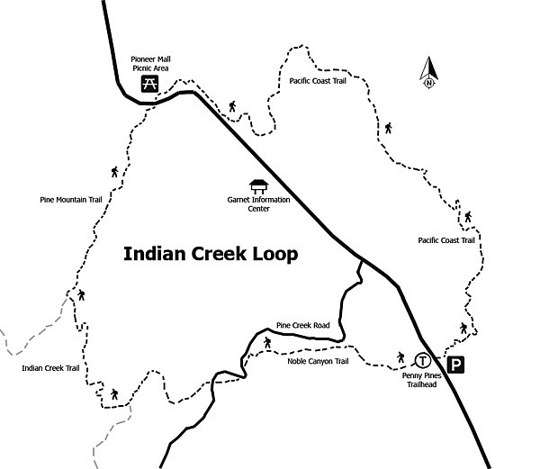
Indian Creek Trail Loop
All 10.6 miles of the trail are above 5000 feet, and the well-signed trail features 2000 feet of elevation change.
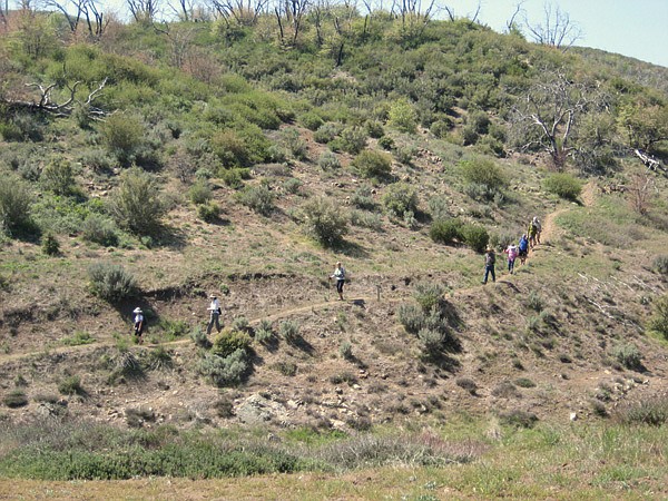
The Indian Creek Trail is full of surprises but does not give them up too easily. The trail meanders through oak woodlands and down narrow canyons to streamside meadows, then climbs up to the chaparral, ending with magnificent views of the desert below. A trail for all seasons, it is exemplary in the spring for wildflowers, in the fall for the changing leaf colors, in summer for workouts, and magical after a winter snowfall. Plan your gear accordingly.
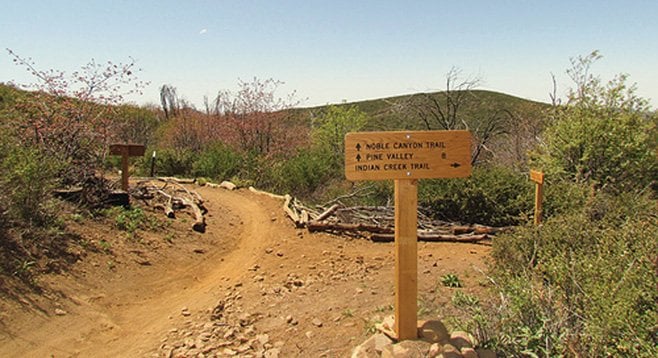
This description begins from the western (clockwise) approach. The trail and junctions are well marked with Cleveland National Forest signposts and distance markers. Parts of the trail are multipurpose, so keep an eye out for mountain bikes and horses. From Penny Pines, take the Noble Canyon trailhead west for approximately 2 miles, first gaining then losing elevation to reach the Indian Creek trail junction toward Champagne Pass. Go right at the Indian Creek Trail, down a series of switchbacks for about a mile to reach the namesake creek at a stream-crossing reminiscent of an alpine meadow with soft grasses and colorful wildflowers. This makes a good resting spot before embarking on the steepest climb of the trail — or as a turnaround point. At the top of a steep quarter-mile climb is Champagne Pass. This is the junction with Pine Mountain Trail on the right; go straight for the continuation of Indian Creek Trail. An unmarked narrow trail on the left, across from the Pine Mountain trailhead, goes uphill to the Champagne Pass Viewpoint barely 100 yards away. After catching your breath, it is worth the detour for a great 360-degree view of the surrounding peaks.
Returning to the junction, take the well-marked Pine Mountain Trail, heading north climbing toward Pioneer Mail approximately 1.5 miles away, across from Sunrise Highway. The Pioneer Mail picnic area has restrooms but no water. Here you will join the Pacific Crest Trail heading south (to the right) for a four-mile hike back to Penny Pines. The PCT runs parallel to and behind the picnic area. The signpost is on the far edge of the dirt parking area. Be sure to head south toward Garnet Peak and not in the direction of Kwaaymii Point. The trail continues to climb to the highest point on the hike at almost 5600 ft. Several spots offer great views of the Anza-Borrego Desert and the Salton Sea to the east. Hearty folks can take the short side-trip to Garnet Peak for a panoramic view of the desert and mountains.
This hike crosses several plant communities in close proximity, from mixed conifer-oak woodlands to riparian (streamside) habitats, to chaparral transitioning into desert. Among notable trees and shrubs are Jeffrey pine, black oak, chokecherry, mountain mahogany, service berry, chamise, mountain manzanita, and ceanothus. Perennials and spring flowers include bush poppy, buttercup, meadow rue, yucca, summer snow, baby blue eyes, mountain violet, scarlet bugler, sun cups, western wallflower, and mariposa lily. Bird-watchers will recognize black-headed grossbeak, Nashville warbler and several flycatchers, along with Steller’s jay, western bluebird, and red-tailed hawk. The PCT section of the hike shows in dramatic fashion how the rise of the Laguna Mountains 1.5 million years ago created the “rain shadow” that resulted in the present-day desert to the east.
- Distance from downtown San Diego: Approximately 60 miles due east of San Diego. Take Interstate 8 east to the Sunrise Highway (SR-1), turn north (left), and proceed 13.5 miles to the Penny Pines turnout near mile-marker 27. Allow 1.5 hours driving time. There is limited parking on both sides of the turnout. There are no facilities at the trailhead, but there are restrooms at the National Forest Service information building next to the Laguna Mountain General Store, approximately 3 miles south of Penny Pines. Forest Service Adventure Pass required.
- Hiking length: This 10.6-mile loop trail can be hiked clockwise or counter-clockwise, depending on whether you prefer to start on the Noble Canyon side to the west or the Pacific Crest Trail’s desert views on the eastern escarpment.
- Difficulty: Strenuous with a total elevation change of approximately 2000 feet at elevations over 5000 feet. The loop can take five to six hours to complete and is not recommended for those with physical limitations that may affect endurance, including small children or the elderly. However, shorter out-and-back options are possible. The trail crosses Indian Creek, but there are no sources of drinking water on the hike.
Here's something you might be interested in.
Indian Creek Trail Loop
Indian Creek Trail Loop
All 10.6 miles of the trail are above 5000 feet, and the well-signed trail features 2000 feet of elevation change.
The Indian Creek Trail is full of surprises but does not give them up too easily. The trail meanders through oak woodlands and down narrow canyons to streamside meadows, then climbs up to the chaparral, ending with magnificent views of the desert below. A trail for all seasons, it is exemplary in the spring for wildflowers, in the fall for the changing leaf colors, in summer for workouts, and magical after a winter snowfall. Plan your gear accordingly.
This description begins from the western (clockwise) approach. The trail and junctions are well marked with Cleveland National Forest signposts and distance markers. Parts of the trail are multipurpose, so keep an eye out for mountain bikes and horses. From Penny Pines, take the Noble Canyon trailhead west for approximately 2 miles, first gaining then losing elevation to reach the Indian Creek trail junction toward Champagne Pass. Go right at the Indian Creek Trail, down a series of switchbacks for about a mile to reach the namesake creek at a stream-crossing reminiscent of an alpine meadow with soft grasses and colorful wildflowers. This makes a good resting spot before embarking on the steepest climb of the trail — or as a turnaround point. At the top of a steep quarter-mile climb is Champagne Pass. This is the junction with Pine Mountain Trail on the right; go straight for the continuation of Indian Creek Trail. An unmarked narrow trail on the left, across from the Pine Mountain trailhead, goes uphill to the Champagne Pass Viewpoint barely 100 yards away. After catching your breath, it is worth the detour for a great 360-degree view of the surrounding peaks.
Returning to the junction, take the well-marked Pine Mountain Trail, heading north climbing toward Pioneer Mail approximately 1.5 miles away, across from Sunrise Highway. The Pioneer Mail picnic area has restrooms but no water. Here you will join the Pacific Crest Trail heading south (to the right) for a four-mile hike back to Penny Pines. The PCT runs parallel to and behind the picnic area. The signpost is on the far edge of the dirt parking area. Be sure to head south toward Garnet Peak and not in the direction of Kwaaymii Point. The trail continues to climb to the highest point on the hike at almost 5600 ft. Several spots offer great views of the Anza-Borrego Desert and the Salton Sea to the east. Hearty folks can take the short side-trip to Garnet Peak for a panoramic view of the desert and mountains.
This hike crosses several plant communities in close proximity, from mixed conifer-oak woodlands to riparian (streamside) habitats, to chaparral transitioning into desert. Among notable trees and shrubs are Jeffrey pine, black oak, chokecherry, mountain mahogany, service berry, chamise, mountain manzanita, and ceanothus. Perennials and spring flowers include bush poppy, buttercup, meadow rue, yucca, summer snow, baby blue eyes, mountain violet, scarlet bugler, sun cups, western wallflower, and mariposa lily. Bird-watchers will recognize black-headed grossbeak, Nashville warbler and several flycatchers, along with Steller’s jay, western bluebird, and red-tailed hawk. The PCT section of the hike shows in dramatic fashion how the rise of the Laguna Mountains 1.5 million years ago created the “rain shadow” that resulted in the present-day desert to the east.
- Distance from downtown San Diego: Approximately 60 miles due east of San Diego. Take Interstate 8 east to the Sunrise Highway (SR-1), turn north (left), and proceed 13.5 miles to the Penny Pines turnout near mile-marker 27. Allow 1.5 hours driving time. There is limited parking on both sides of the turnout. There are no facilities at the trailhead, but there are restrooms at the National Forest Service information building next to the Laguna Mountain General Store, approximately 3 miles south of Penny Pines. Forest Service Adventure Pass required.
- Hiking length: This 10.6-mile loop trail can be hiked clockwise or counter-clockwise, depending on whether you prefer to start on the Noble Canyon side to the west or the Pacific Crest Trail’s desert views on the eastern escarpment.
- Difficulty: Strenuous with a total elevation change of approximately 2000 feet at elevations over 5000 feet. The loop can take five to six hours to complete and is not recommended for those with physical limitations that may affect endurance, including small children or the elderly. However, shorter out-and-back options are possible. The trail crosses Indian Creek, but there are no sources of drinking water on the hike.