Here's something you might be interested in.
Ask a Hipster — Advice you didn't know you needed
Big Screen — Movie commentary
Blurt — Music's inside track
Booze News — San Diego spirits
Classical Music — Immortal beauty
Classifieds — Free and easy
Cover Stories — Front-page features
Drinks All Around — Bartenders' drink recipes
Excerpts — Literary and spiritual excerpts
Feast! — Food & drink reviews
Feature Stories — Local news & stories
Fishing Report — What’s getting hooked from ship and shore
From the Archives — Spotlight on the past
Golden Dreams — Talk of the town
The Gonzo Report — Making the musical scene, or at least reporting from it
Letters — Our inbox
Movies@Home — Local movie buffs share favorites
Movie Reviews — Our critics' picks and pans
Musician Interviews — Up close with local artists
Neighborhood News from Stringers — Hyperlocal news
News Ticker — News & politics
Obermeyer — San Diego politics illustrated
Outdoors — Weekly changes in flora and fauna
Overheard in San Diego — Eavesdropping illustrated
Poetry — The old and the new
Reader Travel — Travel section built by travelers
Reading — The hunt for intellectuals
Roam-O-Rama — SoCal's best hiking/biking trails
San Diego Beer — Inside San Diego suds
SD on the QT — Almost factual news
Sheep and Goats — Places of worship
Special Issues — The best of
Street Style — San Diego streets have style
Surf Diego — Real stories from those braving the waves
Theater — On stage in San Diego this week
Tin Fork — Silver spoon alternative
Under the Radar — Matt Potter's undercover work
Unforgettable — Long-ago San Diego
Unreal Estate — San Diego's priciest pads
Your Week — Daily event picks
Secret Canyon: Pine Valley Creek Wilderness Trail
Follow the verdant corridor of Pine Valley Creek, cross a gorge, and follow a historic flume.
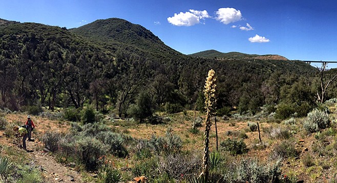
Wide open spaces in Secret Canyon
Pine Valley Creek flows from the Laguna Mountains into Barrett Reservoir, passing through Secret Canyon on its descent. Most of the trail (about 14 miles) traverses the 13,000-acre Pine Creek Wilderness in the Cleveland National Forest. The trail is accessible from two locations: in the north from the Pine Creek Trailhead (described here) off Old Highway 80, and from the south at Horsethief Trailhead.
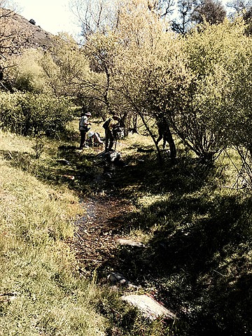
The shorter 2.5-mile option (5 miles round trip) along Pine Creek will take you under the I-8 bridge and to the start of the flume, leaving time to cool your feet in the creek and watch the birds that favor the canyon’s riparian woodland before returning.
Pine Valley Creek Wilderness Trail
The creek and wilderness support diverse habitats, and a few pine trees dot the canyon above the bridge, along with coast live oak, manzanita, arroyo willow, elderberry and a healthy understory of wild rose, basketbush, honeysuckle, and, yes, poison oak. Along the trail you’ll find grape-soda lupine, larkspur, scarlet bugler, Chinese houses, Indian paintbrush, yellow violet, monkeyflower, and even prickly pear cactus. Great basin sagebrush and buckwheat dominate the slopes above the canyon, and the charred remains of the 2007 fires are a reminder of its impacts on this environment.
Pick up the trail at the south end of the Pine Creek parking lot and descend to cross Pine Valley Creek (when it’s running) then climb to the oak-lined east bank. The upper section courses alongside Pine Valley Creek, passing under the more-than-400-foot-tall Pine Valley Bridge on I-8, then winding above the canyon to follow a dry-laid stone flume that was constructed to transport water to a reservoir that was never built.
After entering the wilderness area (close the gate that’s meant to exclude cattle), which is at the 1.8-mile mark, there will be an upward view of the lofty Pine Valley or Nello Irwin Greer Memorial Bridge, constructed in 1974. Another 0.7 mile past the bridge, the trail joins the flume line. Built in 1895, this flume was intended to divert water from a reservoir in Pine Valley to King Creek, a tributary of the San Diego River, and then on to the growing San Diego metropolis. Never completed, sections of the remaining stone flume were used in 1992 to construct the Secret Canyon Trail. After taking in a view of the immense wilderness area, this is the turnaround for the 5-mile out-and-back, which will give you time to enjoy that creek-side repast.
For those continuing on for the longer hike, at 6 miles there’s an up-and-over stretch where a tunnel for the flume was never constructed. The trail leaves the flume bed at 7 miles and descends into Nelson Canyon. A few miles further the trail crosses Pine Valley Creek again and travels through remote Secret Canyon. The lower reaches of the trail are steep and often hard to find. Whenever the trail crosses or follows drainage, it is often overgrown with “head-high” poison oak. The trail was cleared in early 2015, but it doesn’t take much rain for chaparral to grow back. Be prepared if the plan is to hike the entire length of the trail. It is rugged, isolated, and hot. GPS or maps and compass, extra water, and the ability to overnight are a must for this hike.
Near Secret Canyon’s confluence with Pine Valley Creek (12.5 miles), the trail climbs and meanders above the draw until it reaches a junction with the Espinosa Trail (13.8 miles). This is the official end of the Pine Creek Trail, but you aren’t done yet. If there is water in the swimming hole, you can take a dip before making the final 1.8-mile hike out of the canyon to the Horsethief Canyon parking lot. Be sure to arrange for a pick up here or position a car ahead of time for this longer hike.
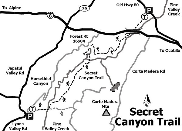
Secret Canyon trail map
Secret Canyon can also be accessed by the Horsethief Canyon trail. From the trailhead parking lot, pass the gate and walk north about a quarter-mile, then follow the steep Espinosa Trail (right) into the canyon. The trail leads to oak-lined Horsethief Canyon, bending right toward Pine Valley Creek. Crossing the creek at 1.5 miles, you pick up the eastward-ascending Espinosa Trail. Walk a short distance up that slope and take the left fork on the unsigned Secret Canyon Trail. A gradual climb follows the canyon above Pine Valley Creek, eventually reaching the riparian woodland of Secret Canyon.
Distance from downtown San Diego: 47 miles. Allow about 1 hour driving time (Pine Valley). Take I-8 E and exit at Pine Valley Rd. Turn north (left) on Pine Valley Rd. and west (left) on Old Highway 80. Drive 1.6 miles and turn south (left) at the Pine Creek Trailhead sign on the Pine Valley-Las Bancas Rd. Drive 0.5 mile and park. A Forest Service Adventure Pass is required to park.
Hiking Length: 5 miles out-and-back or 15.6 miles to Horsethief Canyon parking area one way.
Difficulty: Moderate to strenuous. Elevation gain/loss for the first 2.5 miles is about 600 feet and for the entire length it is 2200 feet. The Pine Creek parking area has a kiosk with a map and facilities.
Here's something you might be interested in.
Secret Canyon: Pine Valley Creek Wilderness Trail
Follow the verdant corridor of Pine Valley Creek, cross a gorge, and follow a historic flume.
Secret Canyon: Pine Valley Creek Wilderness Trail
Follow the verdant corridor of Pine Valley Creek, cross a gorge, and follow a historic flume.
Wide open spaces in Secret Canyon
Pine Valley Creek flows from the Laguna Mountains into Barrett Reservoir, passing through Secret Canyon on its descent. Most of the trail (about 14 miles) traverses the 13,000-acre Pine Creek Wilderness in the Cleveland National Forest. The trail is accessible from two locations: in the north from the Pine Creek Trailhead (described here) off Old Highway 80, and from the south at Horsethief Trailhead.
The shorter 2.5-mile option (5 miles round trip) along Pine Creek will take you under the I-8 bridge and to the start of the flume, leaving time to cool your feet in the creek and watch the birds that favor the canyon’s riparian woodland before returning.
Pine Valley Creek Wilderness Trail
The creek and wilderness support diverse habitats, and a few pine trees dot the canyon above the bridge, along with coast live oak, manzanita, arroyo willow, elderberry and a healthy understory of wild rose, basketbush, honeysuckle, and, yes, poison oak. Along the trail you’ll find grape-soda lupine, larkspur, scarlet bugler, Chinese houses, Indian paintbrush, yellow violet, monkeyflower, and even prickly pear cactus. Great basin sagebrush and buckwheat dominate the slopes above the canyon, and the charred remains of the 2007 fires are a reminder of its impacts on this environment.
Pick up the trail at the south end of the Pine Creek parking lot and descend to cross Pine Valley Creek (when it’s running) then climb to the oak-lined east bank. The upper section courses alongside Pine Valley Creek, passing under the more-than-400-foot-tall Pine Valley Bridge on I-8, then winding above the canyon to follow a dry-laid stone flume that was constructed to transport water to a reservoir that was never built.
After entering the wilderness area (close the gate that’s meant to exclude cattle), which is at the 1.8-mile mark, there will be an upward view of the lofty Pine Valley or Nello Irwin Greer Memorial Bridge, constructed in 1974. Another 0.7 mile past the bridge, the trail joins the flume line. Built in 1895, this flume was intended to divert water from a reservoir in Pine Valley to King Creek, a tributary of the San Diego River, and then on to the growing San Diego metropolis. Never completed, sections of the remaining stone flume were used in 1992 to construct the Secret Canyon Trail. After taking in a view of the immense wilderness area, this is the turnaround for the 5-mile out-and-back, which will give you time to enjoy that creek-side repast.
For those continuing on for the longer hike, at 6 miles there’s an up-and-over stretch where a tunnel for the flume was never constructed. The trail leaves the flume bed at 7 miles and descends into Nelson Canyon. A few miles further the trail crosses Pine Valley Creek again and travels through remote Secret Canyon. The lower reaches of the trail are steep and often hard to find. Whenever the trail crosses or follows drainage, it is often overgrown with “head-high” poison oak. The trail was cleared in early 2015, but it doesn’t take much rain for chaparral to grow back. Be prepared if the plan is to hike the entire length of the trail. It is rugged, isolated, and hot. GPS or maps and compass, extra water, and the ability to overnight are a must for this hike.
Near Secret Canyon’s confluence with Pine Valley Creek (12.5 miles), the trail climbs and meanders above the draw until it reaches a junction with the Espinosa Trail (13.8 miles). This is the official end of the Pine Creek Trail, but you aren’t done yet. If there is water in the swimming hole, you can take a dip before making the final 1.8-mile hike out of the canyon to the Horsethief Canyon parking lot. Be sure to arrange for a pick up here or position a car ahead of time for this longer hike.
Secret Canyon trail map
Secret Canyon can also be accessed by the Horsethief Canyon trail. From the trailhead parking lot, pass the gate and walk north about a quarter-mile, then follow the steep Espinosa Trail (right) into the canyon. The trail leads to oak-lined Horsethief Canyon, bending right toward Pine Valley Creek. Crossing the creek at 1.5 miles, you pick up the eastward-ascending Espinosa Trail. Walk a short distance up that slope and take the left fork on the unsigned Secret Canyon Trail. A gradual climb follows the canyon above Pine Valley Creek, eventually reaching the riparian woodland of Secret Canyon.
Distance from downtown San Diego: 47 miles. Allow about 1 hour driving time (Pine Valley). Take I-8 E and exit at Pine Valley Rd. Turn north (left) on Pine Valley Rd. and west (left) on Old Highway 80. Drive 1.6 miles and turn south (left) at the Pine Creek Trailhead sign on the Pine Valley-Las Bancas Rd. Drive 0.5 mile and park. A Forest Service Adventure Pass is required to park.
Hiking Length: 5 miles out-and-back or 15.6 miles to Horsethief Canyon parking area one way.
Difficulty: Moderate to strenuous. Elevation gain/loss for the first 2.5 miles is about 600 feet and for the entire length it is 2200 feet. The Pine Creek parking area has a kiosk with a map and facilities.
Comments