Here's something you might be interested in.
Ask a Hipster — Advice you didn't know you needed
Big Screen — Movie commentary
Blurt — Music's inside track
Booze News — San Diego spirits
Classical Music — Immortal beauty
Classifieds — Free and easy
Cover Stories — Front-page features
Drinks All Around — Bartenders' drink recipes
Excerpts — Literary and spiritual excerpts
Feast! — Food & drink reviews
Feature Stories — Local news & stories
Fishing Report — What’s getting hooked from ship and shore
From the Archives — Spotlight on the past
Golden Dreams — Talk of the town
The Gonzo Report — Making the musical scene, or at least reporting from it
Letters — Our inbox
Movies@Home — Local movie buffs share favorites
Movie Reviews — Our critics' picks and pans
Musician Interviews — Up close with local artists
Neighborhood News from Stringers — Hyperlocal news
News Ticker — News & politics
Obermeyer — San Diego politics illustrated
Outdoors — Weekly changes in flora and fauna
Overheard in San Diego — Eavesdropping illustrated
Poetry — The old and the new
Reader Travel — Travel section built by travelers
Reading — The hunt for intellectuals
Roam-O-Rama — SoCal's best hiking/biking trails
San Diego Beer — Inside San Diego suds
SD on the QT — Almost factual news
Sheep and Goats — Places of worship
Special Issues — The best of
Street Style — San Diego streets have style
Surf Diego — Real stories from those braving the waves
Theater — On stage in San Diego this week
Tin Fork — Silver spoon alternative
Under the Radar — Matt Potter's undercover work
Unforgettable — Long-ago San Diego
Unreal Estate — San Diego's priciest pads
Your Week — Daily event picks
Ain’t no water in Horsethief Canyon, but poison oak? You bet
Vistas of surrounding mountains and canyons in a protected wilderness area

The checkered white is a common North American butterfly.
Horsethief Canyon is within the 13,480-acre Pine Creek Wilderness area that is managed by the U.S. Forest Service. It is also part of the National Wilderness Preservation System and was so designated a wilderness area by Congress in 1984. No motor vehicles or campfires are allowed. Habitats found in this wilderness area include chaparral-covered hillsides and scrub oak with riparian and oak woodland vegetation along streambeds. During the 1870s and 1880s, horse thieves discovered that the canyon was a perfect corral to hide their stolen horses until they were able to drive them across the border into Mexico. Today this wilderness area is valued for its natural resources, riparian zones, and small beautiful meadows.
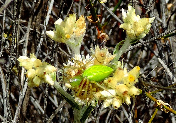
Green lynx spider
The first mile of the two hikes is on the same route. The trailhead is just behind the kiosk in the staging area. Enter the trail through a gate that drops down onto Las Bancas-Horsethief Road. After about 0.25 mile, just after a large bend in the road to the left, the unnamed trail is to the right. It drops down 400 feet fairly steeply through a chaparral landscape into Horsethief Canyon. During the spring, one can see an abundance of yellow, red, and blue wildflowers. At the bottom of the steep part of the trail, there is a small meadow with old oak and sycamore trees. It is here that the trail splits into the two hikes.
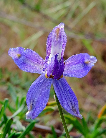
Parrys larkspur (Delphinium parryi)
For the 3.2-mile loop trail, take the left (northwest) leg at the “T” junction of the trail. The trail is narrower in this direction and is not maintained by the forest service. The trail goes through a delightful narrow valley that parallels the dry stream bed. The further distance traveled, the narrower the canyon becomes. However, as the canyon walls close in so does the poison oak. As there is also an abundance of basket bush mixed with the poison oak along this trail, it is necessary to look carefully. Both have leaves in three, but poison oak’s middle leaf is on a small stem—“leaves in three, middle free, let it be.” In a couple of places the trail is blocked by fallen debris, but there are alternate routes around the obstruction. After enjoying this trail for about 0.75 mile, it climbs slightly up back onto Las Bancas-Horsethief Road. The 1.75 mile return trip is much gentler than climbing out of the canyon on the Espinosa Trail. It also provides the opportunity to view the surrounding mountains and Horsethief Canyon from above.
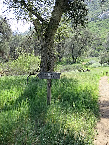
Espinosa trail to secret canyon
For the 5.2 mile out-and-back hike, take the Espinosa Trail, which is the right (west) leg of the “T” junction and travel on the wider, maintained path. This trail, which leads to Secret Canyon, is fairly wide and there is very little poison oak to worry about. During the spring there are many wildflowers to be seen, such as lupine, bush penstemon, and Chinese-houses. The trail is generally flat and open with sycamore and old oak trees interspersed with small meadows here and there. A good stopping place on this trail is the pool on Pine Valley Creek. Unfortunately, during drought conditions, there may be very little water in the pool, but one can still enjoy the shapes and colors of the rocks that have been sculpted by the water in the past. Here you can see grinding rocks with many mortero holes and imagine the past when a band of Kumeyaay Indians made camp during their annual journey from the coast to the mountains. From the pool, the Espinosa trail ascends where shortly it is possible to access the Secret Canyon Trail and continue hiking north to Pine Valley, but that is a very strenuous hike of over 15 miles one-way. To return to the trailhead, retrace your steps and see the trail from a different perspective.
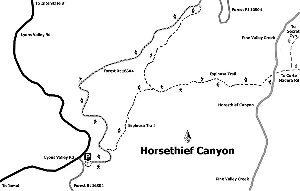
Horsethief Canyon trail map
HORSETHIEF CANYON – PINE CREEK WILDERNESS
Distance from downtown San Diego: 46 miles. Allow 50 minutes driving time (Cleveland National Forest). Take I-8 E, exit at SR-79/Japatul Valley Rd., turning south on Japatul Valley Rd. Drive 5.5 miles and turn south (left) onto Lyons Valley Rd. Drive 1.5 miles to the Japatul Fire Station at mile-marker 16.4. Turn left and left again into the substantial staging area. A Forest Service Adventure Pass is required for vehicles.
Hiking length: 3.2-mile loop or a 5.2 miles out-and-back.
Difficulty: Moderate with total elevation gain/loss of 575 feet. The access to both hikes is down a fairly steep, rocky path that drops 400 feet in about 0.75 mile. Once in the canyon the terrain is fairly flat and even. Equestrians, bicycles, and dogs (on leashes) allowed. No facilities or water.
Here's something you might be interested in.
Ain’t no water in Horsethief Canyon, but poison oak? You bet
Vistas of surrounding mountains and canyons in a protected wilderness area
Ain’t no water in Horsethief Canyon, but poison oak? You bet
Vistas of surrounding mountains and canyons in a protected wilderness area
The checkered white is a common North American butterfly.
Horsethief Canyon is within the 13,480-acre Pine Creek Wilderness area that is managed by the U.S. Forest Service. It is also part of the National Wilderness Preservation System and was so designated a wilderness area by Congress in 1984. No motor vehicles or campfires are allowed. Habitats found in this wilderness area include chaparral-covered hillsides and scrub oak with riparian and oak woodland vegetation along streambeds. During the 1870s and 1880s, horse thieves discovered that the canyon was a perfect corral to hide their stolen horses until they were able to drive them across the border into Mexico. Today this wilderness area is valued for its natural resources, riparian zones, and small beautiful meadows.
Green lynx spider
The first mile of the two hikes is on the same route. The trailhead is just behind the kiosk in the staging area. Enter the trail through a gate that drops down onto Las Bancas-Horsethief Road. After about 0.25 mile, just after a large bend in the road to the left, the unnamed trail is to the right. It drops down 400 feet fairly steeply through a chaparral landscape into Horsethief Canyon. During the spring, one can see an abundance of yellow, red, and blue wildflowers. At the bottom of the steep part of the trail, there is a small meadow with old oak and sycamore trees. It is here that the trail splits into the two hikes.
Parrys larkspur (Delphinium parryi)
For the 3.2-mile loop trail, take the left (northwest) leg at the “T” junction of the trail. The trail is narrower in this direction and is not maintained by the forest service. The trail goes through a delightful narrow valley that parallels the dry stream bed. The further distance traveled, the narrower the canyon becomes. However, as the canyon walls close in so does the poison oak. As there is also an abundance of basket bush mixed with the poison oak along this trail, it is necessary to look carefully. Both have leaves in three, but poison oak’s middle leaf is on a small stem—“leaves in three, middle free, let it be.” In a couple of places the trail is blocked by fallen debris, but there are alternate routes around the obstruction. After enjoying this trail for about 0.75 mile, it climbs slightly up back onto Las Bancas-Horsethief Road. The 1.75 mile return trip is much gentler than climbing out of the canyon on the Espinosa Trail. It also provides the opportunity to view the surrounding mountains and Horsethief Canyon from above.
Espinosa trail to secret canyon
For the 5.2 mile out-and-back hike, take the Espinosa Trail, which is the right (west) leg of the “T” junction and travel on the wider, maintained path. This trail, which leads to Secret Canyon, is fairly wide and there is very little poison oak to worry about. During the spring there are many wildflowers to be seen, such as lupine, bush penstemon, and Chinese-houses. The trail is generally flat and open with sycamore and old oak trees interspersed with small meadows here and there. A good stopping place on this trail is the pool on Pine Valley Creek. Unfortunately, during drought conditions, there may be very little water in the pool, but one can still enjoy the shapes and colors of the rocks that have been sculpted by the water in the past. Here you can see grinding rocks with many mortero holes and imagine the past when a band of Kumeyaay Indians made camp during their annual journey from the coast to the mountains. From the pool, the Espinosa trail ascends where shortly it is possible to access the Secret Canyon Trail and continue hiking north to Pine Valley, but that is a very strenuous hike of over 15 miles one-way. To return to the trailhead, retrace your steps and see the trail from a different perspective.
Horsethief Canyon trail map
HORSETHIEF CANYON – PINE CREEK WILDERNESS
Distance from downtown San Diego: 46 miles. Allow 50 minutes driving time (Cleveland National Forest). Take I-8 E, exit at SR-79/Japatul Valley Rd., turning south on Japatul Valley Rd. Drive 5.5 miles and turn south (left) onto Lyons Valley Rd. Drive 1.5 miles to the Japatul Fire Station at mile-marker 16.4. Turn left and left again into the substantial staging area. A Forest Service Adventure Pass is required for vehicles.
Hiking length: 3.2-mile loop or a 5.2 miles out-and-back.
Difficulty: Moderate with total elevation gain/loss of 575 feet. The access to both hikes is down a fairly steep, rocky path that drops 400 feet in about 0.75 mile. Once in the canyon the terrain is fairly flat and even. Equestrians, bicycles, and dogs (on leashes) allowed. No facilities or water.
Comments