Here's something you might be interested in.
Ask a Hipster — Advice you didn't know you needed
Big Screen — Movie commentary
Blurt — Music's inside track
Booze News — San Diego spirits
Classical Music — Immortal beauty
Classifieds — Free and easy
Cover Stories — Front-page features
Drinks All Around — Bartenders' drink recipes
Excerpts — Literary and spiritual excerpts
Feast! — Food & drink reviews
Feature Stories — Local news & stories
Fishing Report — What’s getting hooked from ship and shore
From the Archives — Spotlight on the past
Golden Dreams — Talk of the town
The Gonzo Report — Making the musical scene, or at least reporting from it
Letters — Our inbox
Movies@Home — Local movie buffs share favorites
Movie Reviews — Our critics' picks and pans
Musician Interviews — Up close with local artists
Neighborhood News from Stringers — Hyperlocal news
News Ticker — News & politics
Obermeyer — San Diego politics illustrated
Outdoors — Weekly changes in flora and fauna
Overheard in San Diego — Eavesdropping illustrated
Poetry — The old and the new
Reader Travel — Travel section built by travelers
Reading — The hunt for intellectuals
Roam-O-Rama — SoCal's best hiking/biking trails
San Diego Beer — Inside San Diego suds
SD on the QT — Almost factual news
Sheep and Goats — Places of worship
Special Issues — The best of
Street Style — San Diego streets have style
Surf Diego — Real stories from those braving the waves
Theater — On stage in San Diego this week
Tin Fork — Silver spoon alternative
Under the Radar — Matt Potter's undercover work
Unforgettable — Long-ago San Diego
Unreal Estate — San Diego's priciest pads
Your Week — Daily event picks
Soot on your pants, the price of entry to Oasis Spring
Indulge your inner botanist on a hike that wins the orchid and overlook award
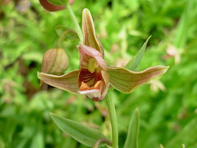
Stream orchid at Oasis Spring
Perennial water, even in the form of a seep, is a rarity in San Diego County in a biological zone generally adapted to drought. Add to this a steep east-west canyon in a north-south mountain range where air funnels up and down the slope. These are the makings for some interesting microenvironments. In a short distance you can find a number of plants unusual for our area, including stream orchids, California bay laurel, and stream lupine. The best time to visit is in spring when the flowers are out. However, there are great views over Storm Canyon any time of the year.
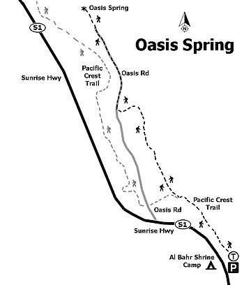
Oasis Spring trail map
The hike starts at the steps down from the overlook and then goes east about 50 feet toward the concrete bench where there is a left turn to join the Pacific Crest Trail (PCT). The nearby trees are Jeffrey pines that survived the 2013 Chariot Fire with some charred bark with green needles only on their upper branches. Along the trail grow buckwheat, tansy-leaf mustard, and white yarrow. The shrubs sprouting from their root-crowns beneath blackened branches are mainly mountain mahogany with their small, deeply ribbed leaves. In addition, there are deciduous Kellogg’s black oak trees with their easily identified large and deeply lobed leaves.
Going north, there is a good view of Garnet Peak; then, to the east, look past the mouth of Storm Canyon to see Earthquake Valley and Whale Peak. To the southeast is the ridge to Foster Point. Be careful where you stand when admiring the views and plants. A red species of harvester ant nests in exposed, sunny areas along or on the trail. It is no problem when walking, but when standing for any length of time, you may find them climbing over your shoes and up your leg. Their stings contain formic acid and are quite painful. For most, the bites are not dangerous but can remain swollen and itchy for days.
Some common flowers seen amid the purple brome grass are morning glory and the splendid mariposa lily with its three violet petals and purple anthers. An uncommon plant that grows here is Parish’s psoralia (Rupertia rigida), a member of the pea family that grows like a low bush with clusters of white flowers and leaves in groups of three, like clover, but where the leaflets are often over two inches long and pointed. Other flowers found along here include imbricate phacelia, wild flax, diamond clarkia, Nuttal’s cinquefoil, Douglas’ wallflower, popcorn flower, pearly everlasting, four-o’clocks, chaparral pea, and scarlet bugler. The rock outcroppings in the trail are gneiss, a metamorphic rock with light and dark bands of minerals twisted by the forces of mountain building.
In 0.25 mile, the trail comes to a small grove of dark-green live oaks that survived the fire. Here the trail switches back. Look for the dandelion-like spear-leafed agoseris, thistles, and purple nightshade. At about 0.3 mile is a wide trail on the left. Stay on the narrow trail, which is clearly marked as PCT on posts on both sides of the junction. The trail goes over a low rise with lotus, white popcorn flowers (Cryptantha spp.), gilias, and storks-bill. At 0.5 mile, the trail drops down the hill. Look for the purple stalks of larkspur. At the bottom of a switchback, the PCT joins an old dirt road from the highway. Follow it with the hill to the right for a short distance until the PCT switches back in the direction of the highway. Leave the PCT here and go straight (north by northwest) on the faint trail in the mostly overgrown old road. In about 50 feet is a burned and fallen oak tree. Climb over the fallen oak. A little soot on your pants is part of the price of entry.
Crown-sprouting mountain mahogany are closely scattered on the hillside with a variety of wildflowers that include purple caraway-leaf gilia, both golden and white yarrow, white popcorn flowers, and occasional thistles and ball gilia. Other crown-sprouting shrubs growing out of the old roadbed are manzanita with hard oval leaves, scrub-oak with small, holly-like leaves, and Palmer’s ceanothus with soft oval leaves. Palmer’s ceanothus is a white-flowered “wild lilac” that has nitrogen-fixing bacteria in nodules on its roots that make it a favorite protein-rich browse plant for deer.
All the burned snags through here make good bird perches. This canyon often fills with bird song with a notable one being the descending call of the spotted towhee, which is a colorful, long-tailed type of sparrow.
Montane wooly-star
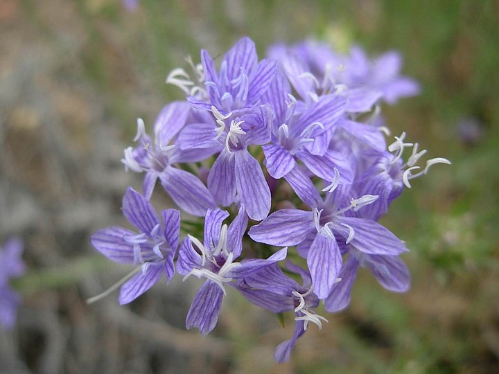
Look for the following plants not yet seen on this hike. The montane wooly-star forms a compact mass of stems about a foot high bearing masses of small, five-petaled flowers colored by parallel blue stripes. Another flower one is sure to notice when it is in bloom is showy penstemon with tall stalks of wide-throated purple flowers.
Just about a mile from the starting point, the old road crosses the gully on the left, which is blocked here by an angled rock and concrete retaining wall that forces any drainage under the road through a pair of four-foot pipes. The trail is now going north along the edge of the escarpment with Garnet Peak again in front. This last third of a mile to the spring contains a concentration of interesting plants. Among the shrubs on the slope to the right are numerous dark green California bay laurel trees, also called Oregon myrtle and pepperwood.
Monardella nana with its tubular thread-thin flowers
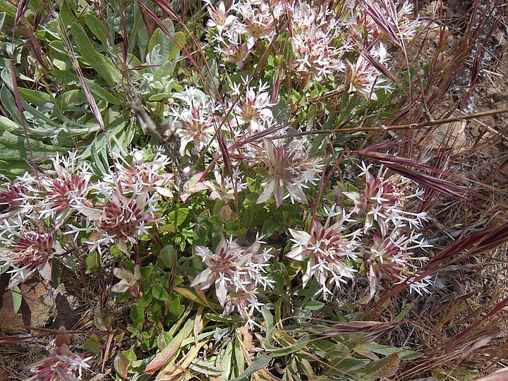
On the edge of the roadbed are low masses of little monardella (Monardella nana) covered with persistent, flower-like bracts even after the tiny, thread-wide flowers are gone. Look for hummingbirds near two species of red, tubular penstemons — scarlet bugler with gray leaves in opposite pairs and bush penstemon with green whorls of three leaves coming out of its wand-like stems. Work your way around elderberry bushes with their flat sprays of either creamy flowers or waxy-blue berries to a seep with damp ground and puddles under a mass of vegetation. The excitement of the spot is the plants. The spring is a tangled mass of big, bush-sized stream lupine with long spikes of blue flowers, large fronds of giant chain ferns, imbricate phacelia, and the stream orchid, which is the star of it all.
The stream orchid (Epipactis gigantea) is greenish with dark purple veins. The two narrow petals spread out on the sides giving it a maximum dimension of about 2.5 inches, which is hardly worthy of the species name gigantea, but it is large compared to the few other orchids that grow in California, which are positively tiny and easily overlooked.
The spring area extends over a fair bit of ground that includes a group of cattails that need standing water to grow. Going farther in this direction would involve trampling the very orchids whose exotic presence is the main draw of this walk. Stop here and return on the same route.
Oasis Spring
Distance from downtown San Diego: 58 miles. Allow 70 minutes driving time (Laguna Mountains). From I-8, exit north onto Sunrise Highway (S-1) for approximately 12.8 miles then turn right and park in the paved viewpoint parking just south of mile marker 26.5.
Hiking length: 2.7 miles out and back.
Difficulty: Easy elevation gain/loss of 300 ft. with the exception of a fallen tree on the unmaintained portion of the trail. No facilities.
Here's something you might be interested in.
Soot on your pants, the price of entry to Oasis Spring
Indulge your inner botanist on a hike that wins the orchid and overlook award
Soot on your pants, the price of entry to Oasis Spring
Indulge your inner botanist on a hike that wins the orchid and overlook award
Stream orchid at Oasis Spring
Perennial water, even in the form of a seep, is a rarity in San Diego County in a biological zone generally adapted to drought. Add to this a steep east-west canyon in a north-south mountain range where air funnels up and down the slope. These are the makings for some interesting microenvironments. In a short distance you can find a number of plants unusual for our area, including stream orchids, California bay laurel, and stream lupine. The best time to visit is in spring when the flowers are out. However, there are great views over Storm Canyon any time of the year.
Oasis Spring trail map
The hike starts at the steps down from the overlook and then goes east about 50 feet toward the concrete bench where there is a left turn to join the Pacific Crest Trail (PCT). The nearby trees are Jeffrey pines that survived the 2013 Chariot Fire with some charred bark with green needles only on their upper branches. Along the trail grow buckwheat, tansy-leaf mustard, and white yarrow. The shrubs sprouting from their root-crowns beneath blackened branches are mainly mountain mahogany with their small, deeply ribbed leaves. In addition, there are deciduous Kellogg’s black oak trees with their easily identified large and deeply lobed leaves.
Going north, there is a good view of Garnet Peak; then, to the east, look past the mouth of Storm Canyon to see Earthquake Valley and Whale Peak. To the southeast is the ridge to Foster Point. Be careful where you stand when admiring the views and plants. A red species of harvester ant nests in exposed, sunny areas along or on the trail. It is no problem when walking, but when standing for any length of time, you may find them climbing over your shoes and up your leg. Their stings contain formic acid and are quite painful. For most, the bites are not dangerous but can remain swollen and itchy for days.
Some common flowers seen amid the purple brome grass are morning glory and the splendid mariposa lily with its three violet petals and purple anthers. An uncommon plant that grows here is Parish’s psoralia (Rupertia rigida), a member of the pea family that grows like a low bush with clusters of white flowers and leaves in groups of three, like clover, but where the leaflets are often over two inches long and pointed. Other flowers found along here include imbricate phacelia, wild flax, diamond clarkia, Nuttal’s cinquefoil, Douglas’ wallflower, popcorn flower, pearly everlasting, four-o’clocks, chaparral pea, and scarlet bugler. The rock outcroppings in the trail are gneiss, a metamorphic rock with light and dark bands of minerals twisted by the forces of mountain building.
In 0.25 mile, the trail comes to a small grove of dark-green live oaks that survived the fire. Here the trail switches back. Look for the dandelion-like spear-leafed agoseris, thistles, and purple nightshade. At about 0.3 mile is a wide trail on the left. Stay on the narrow trail, which is clearly marked as PCT on posts on both sides of the junction. The trail goes over a low rise with lotus, white popcorn flowers (Cryptantha spp.), gilias, and storks-bill. At 0.5 mile, the trail drops down the hill. Look for the purple stalks of larkspur. At the bottom of a switchback, the PCT joins an old dirt road from the highway. Follow it with the hill to the right for a short distance until the PCT switches back in the direction of the highway. Leave the PCT here and go straight (north by northwest) on the faint trail in the mostly overgrown old road. In about 50 feet is a burned and fallen oak tree. Climb over the fallen oak. A little soot on your pants is part of the price of entry.
Crown-sprouting mountain mahogany are closely scattered on the hillside with a variety of wildflowers that include purple caraway-leaf gilia, both golden and white yarrow, white popcorn flowers, and occasional thistles and ball gilia. Other crown-sprouting shrubs growing out of the old roadbed are manzanita with hard oval leaves, scrub-oak with small, holly-like leaves, and Palmer’s ceanothus with soft oval leaves. Palmer’s ceanothus is a white-flowered “wild lilac” that has nitrogen-fixing bacteria in nodules on its roots that make it a favorite protein-rich browse plant for deer.
All the burned snags through here make good bird perches. This canyon often fills with bird song with a notable one being the descending call of the spotted towhee, which is a colorful, long-tailed type of sparrow.
Montane wooly-star
Look for the following plants not yet seen on this hike. The montane wooly-star forms a compact mass of stems about a foot high bearing masses of small, five-petaled flowers colored by parallel blue stripes. Another flower one is sure to notice when it is in bloom is showy penstemon with tall stalks of wide-throated purple flowers.
Just about a mile from the starting point, the old road crosses the gully on the left, which is blocked here by an angled rock and concrete retaining wall that forces any drainage under the road through a pair of four-foot pipes. The trail is now going north along the edge of the escarpment with Garnet Peak again in front. This last third of a mile to the spring contains a concentration of interesting plants. Among the shrubs on the slope to the right are numerous dark green California bay laurel trees, also called Oregon myrtle and pepperwood.
Monardella nana with its tubular thread-thin flowers
On the edge of the roadbed are low masses of little monardella (Monardella nana) covered with persistent, flower-like bracts even after the tiny, thread-wide flowers are gone. Look for hummingbirds near two species of red, tubular penstemons — scarlet bugler with gray leaves in opposite pairs and bush penstemon with green whorls of three leaves coming out of its wand-like stems. Work your way around elderberry bushes with their flat sprays of either creamy flowers or waxy-blue berries to a seep with damp ground and puddles under a mass of vegetation. The excitement of the spot is the plants. The spring is a tangled mass of big, bush-sized stream lupine with long spikes of blue flowers, large fronds of giant chain ferns, imbricate phacelia, and the stream orchid, which is the star of it all.
The stream orchid (Epipactis gigantea) is greenish with dark purple veins. The two narrow petals spread out on the sides giving it a maximum dimension of about 2.5 inches, which is hardly worthy of the species name gigantea, but it is large compared to the few other orchids that grow in California, which are positively tiny and easily overlooked.
The spring area extends over a fair bit of ground that includes a group of cattails that need standing water to grow. Going farther in this direction would involve trampling the very orchids whose exotic presence is the main draw of this walk. Stop here and return on the same route.
Oasis Spring
Distance from downtown San Diego: 58 miles. Allow 70 minutes driving time (Laguna Mountains). From I-8, exit north onto Sunrise Highway (S-1) for approximately 12.8 miles then turn right and park in the paved viewpoint parking just south of mile marker 26.5.
Hiking length: 2.7 miles out and back.
Difficulty: Easy elevation gain/loss of 300 ft. with the exception of a fallen tree on the unmaintained portion of the trail. No facilities.
Comments