Here's something you might be interested in.
Ask a Hipster — Advice you didn't know you needed
Big Screen — Movie commentary
Blurt — Music's inside track
Booze News — San Diego spirits
Classical Music — Immortal beauty
Classifieds — Free and easy
Cover Stories — Front-page features
Drinks All Around — Bartenders' drink recipes
Excerpts — Literary and spiritual excerpts
Feast! — Food & drink reviews
Feature Stories — Local news & stories
Fishing Report — What’s getting hooked from ship and shore
From the Archives — Spotlight on the past
Golden Dreams — Talk of the town
The Gonzo Report — Making the musical scene, or at least reporting from it
Letters — Our inbox
Movies@Home — Local movie buffs share favorites
Movie Reviews — Our critics' picks and pans
Musician Interviews — Up close with local artists
Neighborhood News from Stringers — Hyperlocal news
News Ticker — News & politics
Obermeyer — San Diego politics illustrated
Outdoors — Weekly changes in flora and fauna
Overheard in San Diego — Eavesdropping illustrated
Poetry — The old and the new
Reader Travel — Travel section built by travelers
Reading — The hunt for intellectuals
Roam-O-Rama — SoCal's best hiking/biking trails
San Diego Beer — Inside San Diego suds
SD on the QT — Almost factual news
Sheep and Goats — Places of worship
Special Issues — The best of
Street Style — San Diego streets have style
Surf Diego — Real stories from those braving the waves
Theater — On stage in San Diego this week
Tin Fork — Silver spoon alternative
Under the Radar — Matt Potter's undercover work
Unforgettable — Long-ago San Diego
Unreal Estate — San Diego's priciest pads
Your Week — Daily event picks
Hiking the Pacific Crest Trail along Agua Caliente Creek
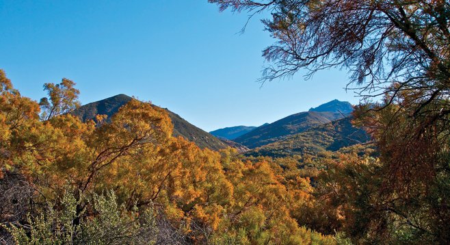
Ribbonwood casts a golden tint to the chaparral-covered hillsides along Agua Caliente Creek
This section of the Pacific Crest Trail is a welcome sight for through-hikers on their way to Canada after spending many days in waterless stretches of the desert. Day-hikers will likewise enjoy the oaks and sycamores alongside a stream as well as some great chaparral and wildflower habitat. In most years, water flows beside several miles of the trail as Agua Caliente Creek descends from the San Ysidro Mountains. However, it is best not to count on water being present since in some years the creek goes dry by late summer.
Initially the trail is just above or on a broad sandy wash studded with towering coast and Engelmann live oaks, interspersed with sagebrush and non-native grasses. The trail here is on Warner Ranch property that the PCT legally crosses as a result of an easement. Numerous horse tracks and a dirt road intertwine, but the PCT is well marked and easily followed. After trudging through the sand for about a mile, the trail crosses the stream and begins a gradual climb up a chaparral-covered hillside, leaving Warner Ranch property and entering the Cleveland National Forest.
Chamise dominates the chaparral at first, but as the trail climbs, ribbonwood, a chamise cousin, becomes more abundant, forming a nearly 20-foot canopy over the trail. When the ribbonwood is in bloom in October, it casts a golden glow over the entire chaparral-covered hillsides. Less frequently encountered is holly-leaf redberry, mountain mahogany, bigberry manzanita, white sage, toyon, ceanothus, scrub oak, sugar bush, Spanish bayonet, Mojave yucca, cane cholla, and desert prickly pear. A late winter or spring visit has an additional reward with numerous blooming herbaceous plants, including golden yarrow, Chinese houses, owl’s clover, paintbrush, showy penstemon, scarlet monkeyflower, and many others.
After hiking about 3 miles, listen for the sound of water flowing over rocks as you descend toward the stream. The trail then follows the stream for almost a mile, crossing it several times. While hiking along the stream, note passing through a riparian forest dominated by coast live oaks, sycamores, arroyo willow, cottonwoods, and Coulter pines. The trees here aren’t as large as those encountered in the first part of the hike, but they are much more numerous and provide almost constant shade.
After nearly 4 miles, the trail leaves the stream and begins to switchback up the hillside. This may be a good point to turn around and retrace your steps. If you were focused on the trail ahead on the way to this point, the journey back is an opportunity to enjoy the views to the west toward Lake Henshaw and Palomar Mountain.
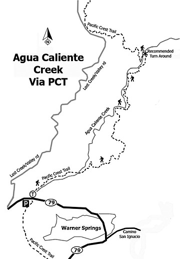
Distance from downtown San Diego: Approximately 68 miles. Allow 1.5 hours driving time. From I-8, exit onto SR-67 north, continuing onto Main St./SR-78 east/Julian Road to Santa Ysabel. Turn left onto SR-79 north and drive about 14 miles. Park in the turnout just beyond a bridge 2.5 miles north of the Warner Springs CALfire station and walk back to the bridge. The PCT goes under the bridge. To reach the trail, start walking east from the northern end of the bridge and soon a small sign “to the PCT” will be visible. No facilities or water.
Hiking length: A little less than 8 miles, out and back.
Difficulty: Intermediate with elevation gain/loss of about 1000 feet. Stream water must be treated before drinking.
Here's something you might be interested in.
Hiking the Pacific Crest Trail along Agua Caliente Creek
Hiking the Pacific Crest Trail along Agua Caliente Creek
Ribbonwood casts a golden tint to the chaparral-covered hillsides along Agua Caliente Creek
This section of the Pacific Crest Trail is a welcome sight for through-hikers on their way to Canada after spending many days in waterless stretches of the desert. Day-hikers will likewise enjoy the oaks and sycamores alongside a stream as well as some great chaparral and wildflower habitat. In most years, water flows beside several miles of the trail as Agua Caliente Creek descends from the San Ysidro Mountains. However, it is best not to count on water being present since in some years the creek goes dry by late summer.
Initially the trail is just above or on a broad sandy wash studded with towering coast and Engelmann live oaks, interspersed with sagebrush and non-native grasses. The trail here is on Warner Ranch property that the PCT legally crosses as a result of an easement. Numerous horse tracks and a dirt road intertwine, but the PCT is well marked and easily followed. After trudging through the sand for about a mile, the trail crosses the stream and begins a gradual climb up a chaparral-covered hillside, leaving Warner Ranch property and entering the Cleveland National Forest.
Chamise dominates the chaparral at first, but as the trail climbs, ribbonwood, a chamise cousin, becomes more abundant, forming a nearly 20-foot canopy over the trail. When the ribbonwood is in bloom in October, it casts a golden glow over the entire chaparral-covered hillsides. Less frequently encountered is holly-leaf redberry, mountain mahogany, bigberry manzanita, white sage, toyon, ceanothus, scrub oak, sugar bush, Spanish bayonet, Mojave yucca, cane cholla, and desert prickly pear. A late winter or spring visit has an additional reward with numerous blooming herbaceous plants, including golden yarrow, Chinese houses, owl’s clover, paintbrush, showy penstemon, scarlet monkeyflower, and many others.
After hiking about 3 miles, listen for the sound of water flowing over rocks as you descend toward the stream. The trail then follows the stream for almost a mile, crossing it several times. While hiking along the stream, note passing through a riparian forest dominated by coast live oaks, sycamores, arroyo willow, cottonwoods, and Coulter pines. The trees here aren’t as large as those encountered in the first part of the hike, but they are much more numerous and provide almost constant shade.
After nearly 4 miles, the trail leaves the stream and begins to switchback up the hillside. This may be a good point to turn around and retrace your steps. If you were focused on the trail ahead on the way to this point, the journey back is an opportunity to enjoy the views to the west toward Lake Henshaw and Palomar Mountain.
Distance from downtown San Diego: Approximately 68 miles. Allow 1.5 hours driving time. From I-8, exit onto SR-67 north, continuing onto Main St./SR-78 east/Julian Road to Santa Ysabel. Turn left onto SR-79 north and drive about 14 miles. Park in the turnout just beyond a bridge 2.5 miles north of the Warner Springs CALfire station and walk back to the bridge. The PCT goes under the bridge. To reach the trail, start walking east from the northern end of the bridge and soon a small sign “to the PCT” will be visible. No facilities or water.
Hiking length: A little less than 8 miles, out and back.
Difficulty: Intermediate with elevation gain/loss of about 1000 feet. Stream water must be treated before drinking.
Comments