Here's something you might be interested in.
Ask a Hipster — Advice you didn't know you needed
Big Screen — Movie commentary
Blurt — Music's inside track
Booze News — San Diego spirits
Classical Music — Immortal beauty
Classifieds — Free and easy
Cover Stories — Front-page features
Drinks All Around — Bartenders' drink recipes
Excerpts — Literary and spiritual excerpts
Feast! — Food & drink reviews
Feature Stories — Local news & stories
Fishing Report — What’s getting hooked from ship and shore
From the Archives — Spotlight on the past
Golden Dreams — Talk of the town
The Gonzo Report — Making the musical scene, or at least reporting from it
Letters — Our inbox
Movies@Home — Local movie buffs share favorites
Movie Reviews — Our critics' picks and pans
Musician Interviews — Up close with local artists
Neighborhood News from Stringers — Hyperlocal news
News Ticker — News & politics
Obermeyer — San Diego politics illustrated
Outdoors — Weekly changes in flora and fauna
Overheard in San Diego — Eavesdropping illustrated
Poetry — The old and the new
Reader Travel — Travel section built by travelers
Reading — The hunt for intellectuals
Roam-O-Rama — SoCal's best hiking/biking trails
San Diego Beer — Inside San Diego suds
SD on the QT — Almost factual news
Sheep and Goats — Places of worship
Special Issues — The best of
Street Style — San Diego streets have style
Surf Diego — Real stories from those braving the waves
Theater — On stage in San Diego this week
Tin Fork — Silver spoon alternative
Under the Radar — Matt Potter's undercover work
Unforgettable — Long-ago San Diego
Unreal Estate — San Diego's priciest pads
Your Week — Daily event picks
Tunnel of shrubs and countless species in the Cuyamacas
Take this short hike to view wildflowers, insects, and post-fire habitat recovery.
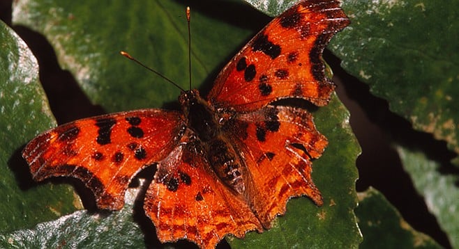
Satyr anglewing butterfly
This short walk has such an array of habitats, insects, and plant species that a longer trek may not reveal much more of nature’s palette in the Cuyamaca Mountains.
The loop is a triangle of three routes beginning across from Campsite No. 7, opposite the West Side Connector Trail — on some maps named Paso Trail, which is the trailhead. The loop goes counterclockwise from the trailhead up the Lookout Fire Road 0.5 mile to the turnoff for the West Side Trail and goes down that trail 0.2 mile to the West Side Trail Connector or the Paso Trail until it returns 0.2 mile to the trailhead.
The trailhead across from Campsite No. 7 can also be accessed from SR-79 by walking to the campground entrance and then south on SR-79 to the paved Lookout Fire Road that goes to the top of Cuyamaca Peak. Walk past a gate that keeps vehicles out (but not pedestrians) and walk about 100 yards to the trailhead labeled “West Side Trail Connector.”
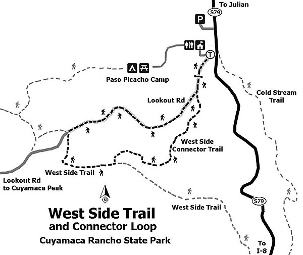
West Side Trail and Connector Loop — Cuyamaca Rancho State Park
Walk south from the day-use parking lot to Campsite No. 7. From the trailhead at the junction of the West Side Connector Trail/Paso Trail and the Lookout Fire Road, hike up the fire road that parallels the campground for half a mile. It’s an easy walk on pavement except for the last 100 yards that become a little steep but not difficult. Because of the devastating fire in 2003, there will be little shade, but some of the trees seen in the distance and in the campground will be the fire survivors of mostly pines and oaks.
In this locale will be three of the four major oak-tree types in San Diego County. Covering the hillsides and along the trail will be coast live oak (Quercus agrifolia). It is the most common oak tree in San Diego County as well as all of California and can be identified by its distinct downward cup-shaped, prickly leaves. Coming back after the fires is the black oak (Quercus kelloggii), which can be identified by its large-lobed, maple-like leaves. It is the county’s only deciduous oak, dropping its leaves in winter where it lives at higher elevations in coniferous forests. The flavor of black-oak acorns were favored by local Indian bands. Less conspicuous and harder to find will be canyon live oak (Quercus chrysolepis), with its flat, thick leaf with golden fuzz on its underside. Missing here is the gray-green and rare Engelmann oaks (Quercus engelmannii). Mixed in with the recovering oaks along either side of the road will be shrubs of countless Palmer’s lilac or ceanothus, many Mexican manzanitas, a few mountain mahoganies, and an occasional elderberry. Spring wildflowers will enhance the experience.
A large roadside plant with elongated leaves in threes branching from the stems is Indian milkweed (Asclepias eriocarpa). Its flowers have a unique look and no “dusty” pollen. Instead, they have little packets (pollinia) of pollen that hitchhike on the spiky legs of the bees and wasps that commonly buzz around the flowers. Colorful red-and-black milkweed bugs, iridescent blue cobalt beetles, and brilliant red longhorn beetles are fun to look for as well as a search for the caterpillars of the monarch butterfly. The rest of the trek will display other milkweed plants to peruse for new insect visitors. As the road continues, other interesting plants begin to show up: a lilac-pink flower called splendid mariposa lily sways on long stems. Low to the ground is the canary-yellow two-inch tall coast baby star, more common further on. Grape-soda lupine (Lupinus excubitus), with an aroma of grape soda from the new buds, will begin to dominate sunny areas.
At 0.5 mile on the fire road is the turnoff to the left (southeast) for the dirt path of the West Side Trail. No longer traveling uphill, the route becomes a gentle descent as the environment begins to change. On your right is a huge block of igneous rock. The Kumeyaay Indians, who inhabited this area for many years, used similar slabs nearby to grind acorns and other materials. The milling of acorns was an important part of food preparation for the native people. They also used other natural resources to sustain a thriving culture.
The rocks on Cuyamaca Peak are a plutonic rock called gabbro. It has dark minerals and weathers without exposing huge boulders. Stonewall Peak is a different plutonic rock called quartz diorite, with lighter minerals and giant crags exposed during weathering. Note the difference as you view both mountains on your walk. The trail here narrows and becomes overgrown. Evidence of past fires includes numerous darkened limbs, downed trees, and stumps. Look at the stumps and study the tree rings for what is most likely Jeffrey pines’ life history. To count the trees age, count the darker summer rings, noticing the lighter spring rings that complete the year. If widely spaced, then the tree grew under optimum conditions; whereas narrow rings most likely indicate drought, crowding, or even an insect infestation.
There is some poison oak (Toxicodendron diversilobum) on the left of this path. Be alert but not overly concerned. The famous “leaflets-of-three-let-it-be” should be enough to prevent any dermatitis issues.
There are untidy thickets of Palmer’s ceanothus along a large stretch of this trail. It is more than 90 percent shade in most places — and damp. This is a surprise on this dry hillside. In the undergrowth of this dank environment is a large stream lupine (Lupinus latifolius), one of the largest lupine species in the state.
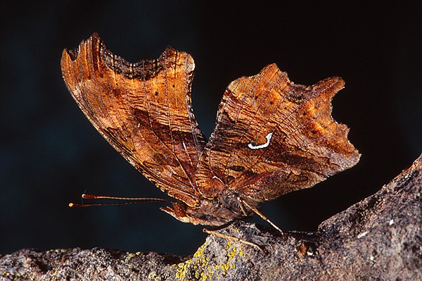
The Satyr angelwing butterfly’s bottom wings are distinctly different.
After 0.2 mile on this trail, turn left (northeast at the marker sign for the “West Side Trail Connector”) and continue through a tunnel of shrubs. Continue on the last leg of the walk for 0.2 mile, where there are more stream lupines and stinging nettle (Urtica dioica). It has beautiful green leaves covered with tiny stinging hairs that can be nine feet tall. Look, but don’t touch, and press on. A fast-flying butterfly in the shade might be the unusual Satyr anglewing. Their caterpillars dine only on nettle while the adults fly, showing wings of orange with black dots, or they hide with their mottled-tan underwings to blend in with tree bark. As you skirt an open meadow and leave the thicketed area, notice sun-loving blooms and butterflies hovering with their proboscis while feeding on nectar. Flitting in the flower fields will be many species of tiny blues, usually around buckwheat or members of the pea family. Other species with caterpillars that eat pea-family plants are yellow sulfur butterflies. The most common white butterfly is the checkered white.
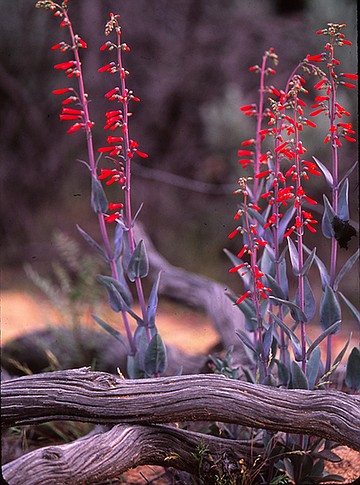
Scarlet bugler (Penstemon centranthifolius)
In the sunshine of the meadow area will be more grape-soda lupines, the tubular flowered scarlet bugler (Penstemon centranthifolius), and the only specimen on the hike of showy penstemon (Penstemon spectabalis). These penstemon species are very different. Scarlet bugler has elongated red flowers while showy penstemons have asymmetrical petals with a fusion of red, blue, and purple. Also along the meadow trail will be California milkweed (Asclepias californica), with maroon-tinged flowers and opposite long soft leaves. Notice how it differs from Indian milkweed seen earlier but still has the same display of insect companions. Toward the end of the hike you will notice a slight ascent with Lookout Road near to close the loop and return to your vehicle.
WEST SIDE TRAIL AND WEST SIDE TRAIL CONNECTOR
Cuyamaca Rancho State Park
Distance from downtown San Diego: About 52 miles. Allow 1 hour driving time (Cuyamaca Mountains). Take I-8 east and exit at SR-79/Japatul Valley Rd. Go north 11.8 miles on SR-79 then turn west into the Paso Picacho Campground. Pay to use the day use lot to the right of the entrance.
Hiking length: About a 1-mile loop.
Difficulty: Easy with one gentle incline mid-hike. Elevation gain/loss 50 feet. Facilities and water.
Here's something you might be interested in.
Tunnel of shrubs and countless species in the Cuyamacas
Take this short hike to view wildflowers, insects, and post-fire habitat recovery.
Tunnel of shrubs and countless species in the Cuyamacas
Take this short hike to view wildflowers, insects, and post-fire habitat recovery.
Satyr anglewing butterfly
This short walk has such an array of habitats, insects, and plant species that a longer trek may not reveal much more of nature’s palette in the Cuyamaca Mountains.
The loop is a triangle of three routes beginning across from Campsite No. 7, opposite the West Side Connector Trail — on some maps named Paso Trail, which is the trailhead. The loop goes counterclockwise from the trailhead up the Lookout Fire Road 0.5 mile to the turnoff for the West Side Trail and goes down that trail 0.2 mile to the West Side Trail Connector or the Paso Trail until it returns 0.2 mile to the trailhead.
The trailhead across from Campsite No. 7 can also be accessed from SR-79 by walking to the campground entrance and then south on SR-79 to the paved Lookout Fire Road that goes to the top of Cuyamaca Peak. Walk past a gate that keeps vehicles out (but not pedestrians) and walk about 100 yards to the trailhead labeled “West Side Trail Connector.”
West Side Trail and Connector Loop — Cuyamaca Rancho State Park
Walk south from the day-use parking lot to Campsite No. 7. From the trailhead at the junction of the West Side Connector Trail/Paso Trail and the Lookout Fire Road, hike up the fire road that parallels the campground for half a mile. It’s an easy walk on pavement except for the last 100 yards that become a little steep but not difficult. Because of the devastating fire in 2003, there will be little shade, but some of the trees seen in the distance and in the campground will be the fire survivors of mostly pines and oaks.
In this locale will be three of the four major oak-tree types in San Diego County. Covering the hillsides and along the trail will be coast live oak (Quercus agrifolia). It is the most common oak tree in San Diego County as well as all of California and can be identified by its distinct downward cup-shaped, prickly leaves. Coming back after the fires is the black oak (Quercus kelloggii), which can be identified by its large-lobed, maple-like leaves. It is the county’s only deciduous oak, dropping its leaves in winter where it lives at higher elevations in coniferous forests. The flavor of black-oak acorns were favored by local Indian bands. Less conspicuous and harder to find will be canyon live oak (Quercus chrysolepis), with its flat, thick leaf with golden fuzz on its underside. Missing here is the gray-green and rare Engelmann oaks (Quercus engelmannii). Mixed in with the recovering oaks along either side of the road will be shrubs of countless Palmer’s lilac or ceanothus, many Mexican manzanitas, a few mountain mahoganies, and an occasional elderberry. Spring wildflowers will enhance the experience.
A large roadside plant with elongated leaves in threes branching from the stems is Indian milkweed (Asclepias eriocarpa). Its flowers have a unique look and no “dusty” pollen. Instead, they have little packets (pollinia) of pollen that hitchhike on the spiky legs of the bees and wasps that commonly buzz around the flowers. Colorful red-and-black milkweed bugs, iridescent blue cobalt beetles, and brilliant red longhorn beetles are fun to look for as well as a search for the caterpillars of the monarch butterfly. The rest of the trek will display other milkweed plants to peruse for new insect visitors. As the road continues, other interesting plants begin to show up: a lilac-pink flower called splendid mariposa lily sways on long stems. Low to the ground is the canary-yellow two-inch tall coast baby star, more common further on. Grape-soda lupine (Lupinus excubitus), with an aroma of grape soda from the new buds, will begin to dominate sunny areas.
At 0.5 mile on the fire road is the turnoff to the left (southeast) for the dirt path of the West Side Trail. No longer traveling uphill, the route becomes a gentle descent as the environment begins to change. On your right is a huge block of igneous rock. The Kumeyaay Indians, who inhabited this area for many years, used similar slabs nearby to grind acorns and other materials. The milling of acorns was an important part of food preparation for the native people. They also used other natural resources to sustain a thriving culture.
The rocks on Cuyamaca Peak are a plutonic rock called gabbro. It has dark minerals and weathers without exposing huge boulders. Stonewall Peak is a different plutonic rock called quartz diorite, with lighter minerals and giant crags exposed during weathering. Note the difference as you view both mountains on your walk. The trail here narrows and becomes overgrown. Evidence of past fires includes numerous darkened limbs, downed trees, and stumps. Look at the stumps and study the tree rings for what is most likely Jeffrey pines’ life history. To count the trees age, count the darker summer rings, noticing the lighter spring rings that complete the year. If widely spaced, then the tree grew under optimum conditions; whereas narrow rings most likely indicate drought, crowding, or even an insect infestation.
There is some poison oak (Toxicodendron diversilobum) on the left of this path. Be alert but not overly concerned. The famous “leaflets-of-three-let-it-be” should be enough to prevent any dermatitis issues.
There are untidy thickets of Palmer’s ceanothus along a large stretch of this trail. It is more than 90 percent shade in most places — and damp. This is a surprise on this dry hillside. In the undergrowth of this dank environment is a large stream lupine (Lupinus latifolius), one of the largest lupine species in the state.
The Satyr angelwing butterfly’s bottom wings are distinctly different.
After 0.2 mile on this trail, turn left (northeast at the marker sign for the “West Side Trail Connector”) and continue through a tunnel of shrubs. Continue on the last leg of the walk for 0.2 mile, where there are more stream lupines and stinging nettle (Urtica dioica). It has beautiful green leaves covered with tiny stinging hairs that can be nine feet tall. Look, but don’t touch, and press on. A fast-flying butterfly in the shade might be the unusual Satyr anglewing. Their caterpillars dine only on nettle while the adults fly, showing wings of orange with black dots, or they hide with their mottled-tan underwings to blend in with tree bark. As you skirt an open meadow and leave the thicketed area, notice sun-loving blooms and butterflies hovering with their proboscis while feeding on nectar. Flitting in the flower fields will be many species of tiny blues, usually around buckwheat or members of the pea family. Other species with caterpillars that eat pea-family plants are yellow sulfur butterflies. The most common white butterfly is the checkered white.
Scarlet bugler (Penstemon centranthifolius)
In the sunshine of the meadow area will be more grape-soda lupines, the tubular flowered scarlet bugler (Penstemon centranthifolius), and the only specimen on the hike of showy penstemon (Penstemon spectabalis). These penstemon species are very different. Scarlet bugler has elongated red flowers while showy penstemons have asymmetrical petals with a fusion of red, blue, and purple. Also along the meadow trail will be California milkweed (Asclepias californica), with maroon-tinged flowers and opposite long soft leaves. Notice how it differs from Indian milkweed seen earlier but still has the same display of insect companions. Toward the end of the hike you will notice a slight ascent with Lookout Road near to close the loop and return to your vehicle.
WEST SIDE TRAIL AND WEST SIDE TRAIL CONNECTOR
Cuyamaca Rancho State Park
Distance from downtown San Diego: About 52 miles. Allow 1 hour driving time (Cuyamaca Mountains). Take I-8 east and exit at SR-79/Japatul Valley Rd. Go north 11.8 miles on SR-79 then turn west into the Paso Picacho Campground. Pay to use the day use lot to the right of the entrance.
Hiking length: About a 1-mile loop.
Difficulty: Easy with one gentle incline mid-hike. Elevation gain/loss 50 feet. Facilities and water.
Comments