Here's something you might be interested in.
Ask a Hipster — Advice you didn't know you needed
Big Screen — Movie commentary
Blurt — Music's inside track
Booze News — San Diego spirits
Classical Music — Immortal beauty
Classifieds — Free and easy
Cover Stories — Front-page features
Drinks All Around — Bartenders' drink recipes
Excerpts — Literary and spiritual excerpts
Feast! — Food & drink reviews
Feature Stories — Local news & stories
Fishing Report — What’s getting hooked from ship and shore
From the Archives — Spotlight on the past
Golden Dreams — Talk of the town
The Gonzo Report — Making the musical scene, or at least reporting from it
Letters — Our inbox
Movies@Home — Local movie buffs share favorites
Movie Reviews — Our critics' picks and pans
Musician Interviews — Up close with local artists
Neighborhood News from Stringers — Hyperlocal news
News Ticker — News & politics
Obermeyer — San Diego politics illustrated
Outdoors — Weekly changes in flora and fauna
Overheard in San Diego — Eavesdropping illustrated
Poetry — The old and the new
Reader Travel — Travel section built by travelers
Reading — The hunt for intellectuals
Roam-O-Rama — SoCal's best hiking/biking trails
San Diego Beer — Inside San Diego suds
SD on the QT — Almost factual news
Sheep and Goats — Places of worship
Special Issues — The best of
Street Style — San Diego streets have style
Surf Diego — Real stories from those braving the waves
Theater — On stage in San Diego this week
Tin Fork — Silver spoon alternative
Under the Radar — Matt Potter's undercover work
Unforgettable — Long-ago San Diego
Unreal Estate — San Diego's priciest pads
Your Week — Daily event picks
Ramble along the shores in Encinitas
The ocean is the high point at this legendary surf spot.
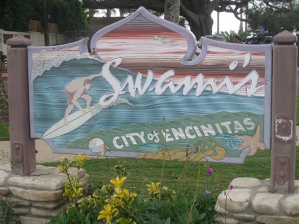
The sign for Swami’s Beach is on the highway, south of the Self-Realization Fellowship
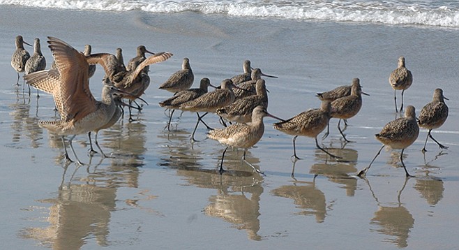
The hike begins at the top of a cliff adjacent to a small park with a few artistic statues. A long stairway leads down to the beach. Here, the ocean is the high point as it blends into the far horizon, creating a beautiful image. The area is popular among surfers as well as shorebirds. The gulls and terns seem accustomed to visitors and allow walkers to pass by at close range. The gulls tend to rummage through the kelp that has washed ashore. These scavengers attempt to find morsels of food clinging to the kelp. The wild-haired terns, on the other hand, hover and dive into the water for their food. Their time on the beach is meant for resting. Keep on the lookout for squadrons of pelicans gliding close to the waterline. Their flying skills are amazing to watch and occasionally one will leave formation to dive for fish.
Walk south along the shoreline with occasional visits to the cliffs. The sandstone cliffs are partially covered with vegetation. Non-natives, including several invasive species, dominate the native plants. There is the occasional native tree tobacco shrub, salt grass, juncus, or heliotrope among the plentiful non-native tamarisk, pampas grass, Arundo donax (or giant cane), and ice plant. Watch for some sandstone blocks at the base of the cliffs near a tree tobacco plant. The tree tobacco has long yellow tubular flowers, which hummingbirds will feed on. Once the blocks of sandstone are located, notice numerous fossilized clams imbedded in the rock. Be on the lookout for ground squirrels or stray lizards that are occasionally found along these cliffs.

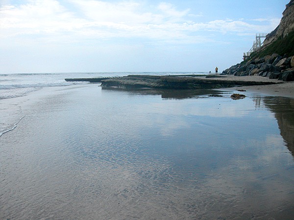
Returning to the shoreline, look for some dimples in the sand each time the water recedes. These are sand crabs, which tickle if you dig your toes into the sand. Upon close inspection, notice the feathery antennae that they use for filter feeding. There are many staircases leading down from the parking area and campground to San Elijo State Beach. As you progress down shore, the cliffs eventually lose elevation. Here, there is an interesting lifeguard tower on scaffolding, which is reminiscent of an erector set. This offsets the lower cliff line and allows the lifeguards greater visibility. Just beyond this tower, there is an inlet for the San Elijo Lagoon. This is the 1.4-mile turnaround point. If you choose to go further, you can wade across the river mouth (at low tide) or walk over the bridge to continue. If you choose to wade across, be cautious of the rounded cobblestones mid-stream. Beyond, there are a few restaurants along the beach and then a narrower stretch of sand, known as Cardiff by the Sea. It is about a mile from the inlet to the cliffs at the south end of this beach.
There is a lot to observe as you amble back along the coast. Be sure to sweep your focus from shore to sea. The reward may be a glimpse of a seal or porpoise visiting the area. In addition, the recommended hiking attire during the summer months is a swimsuit, as it is hard to resist a dip in the ocean. If you are after solitude, the north end of the beach (nearest Swami’s) tends to be less crowded. However, sunsets are glorious anywhere along this stretch of shoreline.
If invigorated, venture a short distance to the north end to explore the flat rocks covered with shallow tide-pool depressions, black mussels, and gooseneck barnacles. Rinse off the saltwater at the base of the stairway as you make your way back to your car.
Distance from downtown San Diego: 28 miles. Allow 32 minutes. Head north on I-5 and exit at Lomas Santa Fe Drive in Solana Beach. Go west to Pacific Coast Highway and turn right. Go 3.2 miles to the turn-off for Swami’s parking lot (just south of Self-Realization Fellowship). If you pass Swami’s pedestrian crossing, you have gone too far. Note: This is a small parking lot. If the lot is full, there may be additional parking available along the highway or by continuing on to K Street. There is also a lot south of Swami’s at San Elijo State Park. That lot has ramp access to the beach (near lifeguard tower # 19).
Hiking length: 1.4 to river mouth (2.8 miles round trip) or 2.5 miles to Cardiff State Beach cliffs (5 miles round trip).
Difficulty: easy/moderate — 145 stairs down to the beach. Elevation gain/loss 75 feet. No facilities. Best at low tide.
Here's something you might be interested in.
Ramble along the shores in Encinitas
The ocean is the high point at this legendary surf spot.
Ramble along the shores in Encinitas
The ocean is the high point at this legendary surf spot.
The sign for Swami’s Beach is on the highway, south of the Self-Realization Fellowship
The hike begins at the top of a cliff adjacent to a small park with a few artistic statues. A long stairway leads down to the beach. Here, the ocean is the high point as it blends into the far horizon, creating a beautiful image. The area is popular among surfers as well as shorebirds. The gulls and terns seem accustomed to visitors and allow walkers to pass by at close range. The gulls tend to rummage through the kelp that has washed ashore. These scavengers attempt to find morsels of food clinging to the kelp. The wild-haired terns, on the other hand, hover and dive into the water for their food. Their time on the beach is meant for resting. Keep on the lookout for squadrons of pelicans gliding close to the waterline. Their flying skills are amazing to watch and occasionally one will leave formation to dive for fish.
Walk south along the shoreline with occasional visits to the cliffs. The sandstone cliffs are partially covered with vegetation. Non-natives, including several invasive species, dominate the native plants. There is the occasional native tree tobacco shrub, salt grass, juncus, or heliotrope among the plentiful non-native tamarisk, pampas grass, Arundo donax (or giant cane), and ice plant. Watch for some sandstone blocks at the base of the cliffs near a tree tobacco plant. The tree tobacco has long yellow tubular flowers, which hummingbirds will feed on. Once the blocks of sandstone are located, notice numerous fossilized clams imbedded in the rock. Be on the lookout for ground squirrels or stray lizards that are occasionally found along these cliffs.
Returning to the shoreline, look for some dimples in the sand each time the water recedes. These are sand crabs, which tickle if you dig your toes into the sand. Upon close inspection, notice the feathery antennae that they use for filter feeding. There are many staircases leading down from the parking area and campground to San Elijo State Beach. As you progress down shore, the cliffs eventually lose elevation. Here, there is an interesting lifeguard tower on scaffolding, which is reminiscent of an erector set. This offsets the lower cliff line and allows the lifeguards greater visibility. Just beyond this tower, there is an inlet for the San Elijo Lagoon. This is the 1.4-mile turnaround point. If you choose to go further, you can wade across the river mouth (at low tide) or walk over the bridge to continue. If you choose to wade across, be cautious of the rounded cobblestones mid-stream. Beyond, there are a few restaurants along the beach and then a narrower stretch of sand, known as Cardiff by the Sea. It is about a mile from the inlet to the cliffs at the south end of this beach.
There is a lot to observe as you amble back along the coast. Be sure to sweep your focus from shore to sea. The reward may be a glimpse of a seal or porpoise visiting the area. In addition, the recommended hiking attire during the summer months is a swimsuit, as it is hard to resist a dip in the ocean. If you are after solitude, the north end of the beach (nearest Swami’s) tends to be less crowded. However, sunsets are glorious anywhere along this stretch of shoreline.
If invigorated, venture a short distance to the north end to explore the flat rocks covered with shallow tide-pool depressions, black mussels, and gooseneck barnacles. Rinse off the saltwater at the base of the stairway as you make your way back to your car.
Distance from downtown San Diego: 28 miles. Allow 32 minutes. Head north on I-5 and exit at Lomas Santa Fe Drive in Solana Beach. Go west to Pacific Coast Highway and turn right. Go 3.2 miles to the turn-off for Swami’s parking lot (just south of Self-Realization Fellowship). If you pass Swami’s pedestrian crossing, you have gone too far. Note: This is a small parking lot. If the lot is full, there may be additional parking available along the highway or by continuing on to K Street. There is also a lot south of Swami’s at San Elijo State Park. That lot has ramp access to the beach (near lifeguard tower # 19).
Hiking length: 1.4 to river mouth (2.8 miles round trip) or 2.5 miles to Cardiff State Beach cliffs (5 miles round trip).
Difficulty: easy/moderate — 145 stairs down to the beach. Elevation gain/loss 75 feet. No facilities. Best at low tide.