Here's something you might be interested in.
Ask a Hipster — Advice you didn't know you needed
Big Screen — Movie commentary
Blurt — Music's inside track
Booze News — San Diego spirits
Classical Music — Immortal beauty
Classifieds — Free and easy
Cover Stories — Front-page features
Drinks All Around — Bartenders' drink recipes
Excerpts — Literary and spiritual excerpts
Feast! — Food & drink reviews
Feature Stories — Local news & stories
Fishing Report — What’s getting hooked from ship and shore
From the Archives — Spotlight on the past
Golden Dreams — Talk of the town
The Gonzo Report — Making the musical scene, or at least reporting from it
Letters — Our inbox
Movies@Home — Local movie buffs share favorites
Movie Reviews — Our critics' picks and pans
Musician Interviews — Up close with local artists
Neighborhood News from Stringers — Hyperlocal news
News Ticker — News & politics
Obermeyer — San Diego politics illustrated
Outdoors — Weekly changes in flora and fauna
Overheard in San Diego — Eavesdropping illustrated
Poetry — The old and the new
Reader Travel — Travel section built by travelers
Reading — The hunt for intellectuals
Roam-O-Rama — SoCal's best hiking/biking trails
San Diego Beer — Inside San Diego suds
SD on the QT — Almost factual news
Sheep and Goats — Places of worship
Special Issues — The best of
Street Style — San Diego streets have style
Surf Diego — Real stories from those braving the waves
Theater — On stage in San Diego this week
Tin Fork — Silver spoon alternative
Under the Radar — Matt Potter's undercover work
Unforgettable — Long-ago San Diego
Unreal Estate — San Diego's priciest pads
Your Week — Daily event picks
Our beaches looked like the East Coast’s millions of years ago
Sandstone pinnacles and pockets guide your way to the crashing waves below
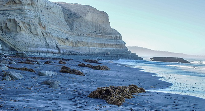
Giant kelp (Macrocyctis pyrifera) often litters the beach segment of the trail.
Established to protect the life forms found within it, the Torrey Pines State Natural Reserve became an official state park in 1956. Found within its borders is the Torrey pine (Pinus torreyana), the rarest pine in North America. The Torrey pine’s native habitat is restricted to the Del Mar area and to Santa Rosa Island. The species itself is unusual, not only for its limited distribution, but also because — though it is a yellow pine similar to Jeffrey and ponderosa pines — its needles occur in bunches of five rather than three, as is found in its relatives.
The Beach Trail is a very popular reserve trail. Runners and fitness walkers like it because it provides a great aerobic workout. Hikers and naturalists enjoy it for its ocean views and the opportunity to explore the rich natural history. The Beach Trail starts across the street from the Lodge at Torrey Pines, on the north side of the restrooms.
The trail is well maintained and signed so you won’t get lost. It passes many Torrey pines, but keep an eye open for the other interesting plants that grow within the park, particularly in the spring when small annual wildflowers are in bloom.
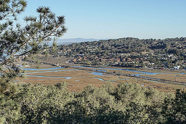
Torrey Pines Beach Trail: view of Los Penasquitos marsh from the park
Winding your way along the trail will take you through coastal sage scrub habitat and down more than 186 steps, eventually leading to a narrow eroded gulch with a stairwell carved from sandstone, marking the final descent to the beach. Caution is necessary in the rainy season, as the steps can be very slippery when wet.
The final stairwell, leading down from the bluffs, takes visitors to Flat Rock Beach, where you can see and climb on the large multi-colored slab that is the beach’s namesake. Millions of years ago, coastal San Diego looked much like the current eastern shoreline of the U.S., mostly flat with barrier islands a few miles off shore.
These islands were composed of sand piled up on a shallow seabed by wave action. Lagoons formed between the barrier islands and the low continental shore where mud, silt, and sand accumulated. Combined with the movement of tectonic plates, the sediments resulted in the formation of a fossil-rich layer of yellow-greenish mudstone rock. Flat Rock is a fragment of this mudstone and is embedded with fossil clam and oyster shells that are easily seen at low tide. Finding the fossils is a great treat for kids while exploring the rock.
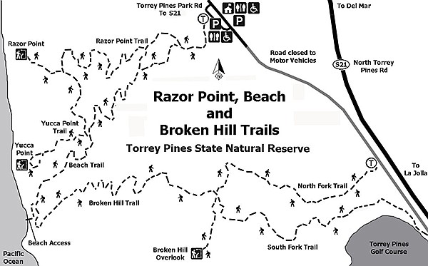
Map for Razor Point, Beach, and Broken Hill Trails
Sand and surf guide visitors back north to the park entrance. If you are lucky, you might find seals resting on the boulders around Flat Rock. Visitors looking for a longer hike should head back up the road to the lodge and begin a new descent back down the sage-scrub slopes or take one of the other trails found within the reserve.
Torrey Pines Beach Trail
Distance from downtown San Diego: approximately 17 miles. Allow 30 minutes driving time (La Jolla). From I-5, go west on Carmel Valley Road for 1.6 miles. Turn left on South Camino Del Mar, which becomes North Torrey Pines Road as you cross into La Jolla. Go 0.9 mile to the park entrance to pay a day-use fee, and then turn left and park in the lot. The parking area has facilities; however, there are no facilities along the trail except near the lodge at the top of the hill.
Hiking length: 1.5 miles out and back.
Difficulty: Moderate due to the elevation gain along the trail and erosion in some areas. The overall elevation gain/loss is about 340 feet. Dogs are not allowed within the reserve or on the beach.
Along the beach, sandstone cliffs tower above the shore. High tides and storm waves break at the foot of the cliff, undermining the soft sandstone and leaving boulders at the foot of the cliffs. The multi-colored sandstone, which looks like a gigantic layered cake, is unstable. The large boulders scattered along the shore serve as a reminder that visitors need to be cautious and stay off the cliffs.
Here's something you might be interested in.
Our beaches looked like the East Coast’s millions of years ago
Sandstone pinnacles and pockets guide your way to the crashing waves below
Our beaches looked like the East Coast’s millions of years ago
Sandstone pinnacles and pockets guide your way to the crashing waves below
Giant kelp (Macrocyctis pyrifera) often litters the beach segment of the trail.
Established to protect the life forms found within it, the Torrey Pines State Natural Reserve became an official state park in 1956. Found within its borders is the Torrey pine (Pinus torreyana), the rarest pine in North America. The Torrey pine’s native habitat is restricted to the Del Mar area and to Santa Rosa Island. The species itself is unusual, not only for its limited distribution, but also because — though it is a yellow pine similar to Jeffrey and ponderosa pines — its needles occur in bunches of five rather than three, as is found in its relatives.
The Beach Trail is a very popular reserve trail. Runners and fitness walkers like it because it provides a great aerobic workout. Hikers and naturalists enjoy it for its ocean views and the opportunity to explore the rich natural history. The Beach Trail starts across the street from the Lodge at Torrey Pines, on the north side of the restrooms.
The trail is well maintained and signed so you won’t get lost. It passes many Torrey pines, but keep an eye open for the other interesting plants that grow within the park, particularly in the spring when small annual wildflowers are in bloom.
Torrey Pines Beach Trail: view of Los Penasquitos marsh from the park
Winding your way along the trail will take you through coastal sage scrub habitat and down more than 186 steps, eventually leading to a narrow eroded gulch with a stairwell carved from sandstone, marking the final descent to the beach. Caution is necessary in the rainy season, as the steps can be very slippery when wet.
The final stairwell, leading down from the bluffs, takes visitors to Flat Rock Beach, where you can see and climb on the large multi-colored slab that is the beach’s namesake. Millions of years ago, coastal San Diego looked much like the current eastern shoreline of the U.S., mostly flat with barrier islands a few miles off shore.
These islands were composed of sand piled up on a shallow seabed by wave action. Lagoons formed between the barrier islands and the low continental shore where mud, silt, and sand accumulated. Combined with the movement of tectonic plates, the sediments resulted in the formation of a fossil-rich layer of yellow-greenish mudstone rock. Flat Rock is a fragment of this mudstone and is embedded with fossil clam and oyster shells that are easily seen at low tide. Finding the fossils is a great treat for kids while exploring the rock.
Map for Razor Point, Beach, and Broken Hill Trails
Sand and surf guide visitors back north to the park entrance. If you are lucky, you might find seals resting on the boulders around Flat Rock. Visitors looking for a longer hike should head back up the road to the lodge and begin a new descent back down the sage-scrub slopes or take one of the other trails found within the reserve.
Torrey Pines Beach Trail
Distance from downtown San Diego: approximately 17 miles. Allow 30 minutes driving time (La Jolla). From I-5, go west on Carmel Valley Road for 1.6 miles. Turn left on South Camino Del Mar, which becomes North Torrey Pines Road as you cross into La Jolla. Go 0.9 mile to the park entrance to pay a day-use fee, and then turn left and park in the lot. The parking area has facilities; however, there are no facilities along the trail except near the lodge at the top of the hill.
Hiking length: 1.5 miles out and back.
Difficulty: Moderate due to the elevation gain along the trail and erosion in some areas. The overall elevation gain/loss is about 340 feet. Dogs are not allowed within the reserve or on the beach.
Along the beach, sandstone cliffs tower above the shore. High tides and storm waves break at the foot of the cliff, undermining the soft sandstone and leaving boulders at the foot of the cliffs. The multi-colored sandstone, which looks like a gigantic layered cake, is unstable. The large boulders scattered along the shore serve as a reminder that visitors need to be cautious and stay off the cliffs.
Comments