Here's something you might be interested in.
Ask a Hipster — Advice you didn't know you needed
Big Screen — Movie commentary
Blurt — Music's inside track
Booze News — San Diego spirits
Classical Music — Immortal beauty
Classifieds — Free and easy
Close to Home — What it’s like on the street where you live
Cover Stories — Front-page features
Drinks All Around — Bartenders' drink recipes
Excerpts — Literary and spiritual excerpts
Feast! — Food & drink reviews
Feature Stories — Local news & stories
Fishing Report — What’s getting hooked from ship and shore
From the Archives — Spotlight on the past
Golden Dreams — Talk of the town
The Gonzo Report — Making the musical scene, or at least reporting from it
Letters — Our inbox
Movies@Home — Local movie buffs share favorites
Movie Reviews — Our critics' picks and pans
Musician Interviews — Up close with local artists
Neighborhood News from Stringers — Hyperlocal news
News Ticker — News & politics
Obermeyer — San Diego politics illustrated
Outdoors — Weekly changes in flora and fauna
Overheard in San Diego — Eavesdropping illustrated
Poetry — The old and the new
Reader Travel — Travel section built by travelers
Reading — The hunt for intellectuals
Roam-O-Rama — SoCal's best hiking/biking trails
San Diego Beer — Inside San Diego suds
SD on the QT — Almost factual news
Sheep and Goats — Places of worship
Special Issues — The best of
Street Style — San Diego streets have style
Surf Diego — Real stories from those braving the waves
Theater — On stage in San Diego this week
Tin Fork — Silver spoon alternative
Under the Radar — Matt Potter's undercover work
Unforgettable — Long-ago San Diego
Unreal Estate — San Diego's priciest pads
Your Week — Daily event picks
Abundant evidence of the Kumeyaay
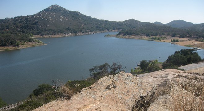
The trail offers a 330-degree view of the lake and surrounding area.
This gem of a trail follows a narrow path between the lake and Lake Wohlford Road. The path is partially open and shaded underneath oak canopies where there are regular views of the lake as well as benches for relaxation. Coast live oaks, Engelmann oaks, and rock formations are plentiful. Interesting boulders and rock slabs are pigmented with yellows and reds of the different types of algae and fungus that make up lichen.
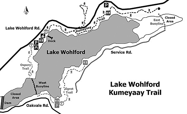
The trail provides many opportunities for viewing ducks, cormorants, egrets, herons, grebes, and terns. There are occasional bald-eagle sightings as well as a resident osprey that may be seen on a nesting platform on the Osprey Trail, located at the west end of the parking lot. White pelicans congregate along the buoy line at the east end of the lake during the winter months. California quail and other woodland birds frequent the area with redwing blackbirds, seen among the cattails and sedges near the docks.
The trailhead is to the left of the entrance, just beyond the Lake Wohlford office trailer. Around the first bend, there is a square slab of stone set up off the trail to the left with morteros on it. The morteros are circular depressions in the rock that were used by the Kumeyaay, local Native Americans, for grinding acorns and other grains. Cross a yellow bridge. The primary rule of thumb will be to venture straight ahead and remain on the trail that parallels the road. The trail also becomes vague in places; however, red arrows painted on rocks and trees help point the way.
At the point where the trail heads down a steeply sloped boulder, there is the option of a side trip to the left that leads to a lookout point. Cross the highway to take this steep trail. Be sure to watch for traffic, as there is a blind curve, and traffic can be heavy at certain times of the day. After crossing the road, look to the right of the large oak tree for the trail. This side trip is well worth the effort. The lookout is built upon the remains of a home site and is surrounded by a rock wall. The City of Escondido has improved the site by adding sitting niches among the rock and a bridge to span a gap at the top. The point provides a 330-degree view of the lake and surrounding area. When finished exploring the top, return to the large sloped boulder to continue down the main trail. The steepness of the rock provides a slight challenge; however, there are protrusions to assist your footing.
Now follow the main trail past rocky sections and wonderful sitting benches. When the trail opens up onto a dirt road, take the right fork past the porta potty. Ignore the trail on the right and continue straight ahead where the trail regains an indistinct, narrow pathway. The trail will become heavily shaded with tall boulders on the left. Use caution when going down a steep slope covered in leaf litter. At the bottom, cross a green bridge and see the remains of an old well, which was once used to provide water to the homes at Lake Wohlford. Next, scramble up a steep slope, to the left of the well. There is a red arrow painted on a tree that points right. Look off the trail to the right where there are a few morteros at the base of a tall boulder. Continuing down the trail are some patches of prickly pear cactus with more morteros soon visible in front and to the right of the trail.
Soon, there will be a collapsed culvert that is the recommended turnaround point. Here you can hop across at your own discretion or return. The trail continues a bit further from here and crosses another culvert via a wooden bridge with stone steps. The narrow trail eventually joins an old service road, which will soon be the required turnaround point. A no-trespassing sign on a road gate marks the end of the trail. A shooting range is beyond this location. Return following the same trail.
- Distance from downtown San Diego: Approximately 38 miles. (Valley Center) From CA-163N, merge onto I-15N, taking the Via Rancho Parkway east exit in Escondido. Via Rancho Parkway will become Bear Valley Parkway. Take this to the end. Turn right on Valley Parkway. Drive through five stoplights to Lake Wohlford Road and turn right. Go 2.6 miles to the lake entrance at 25453 Lake Wohlford Road (on the right). The parking lot is to the right. Restrooms are available.
- Hiking length: 2 miles round trip with optional 0.5-mile extension.
- Difficulty: Easy/Moderate + optional strenuous extension. There are rocks in certain sections and one sloped boulder-scramble, though mostly flat. The optional spur portion is 130 steps to the top of a lookout point and return.
Here's something you might be interested in.
Abundant evidence of the Kumeyaay
Abundant evidence of the Kumeyaay
The trail offers a 330-degree view of the lake and surrounding area.
This gem of a trail follows a narrow path between the lake and Lake Wohlford Road. The path is partially open and shaded underneath oak canopies where there are regular views of the lake as well as benches for relaxation. Coast live oaks, Engelmann oaks, and rock formations are plentiful. Interesting boulders and rock slabs are pigmented with yellows and reds of the different types of algae and fungus that make up lichen.
The trail provides many opportunities for viewing ducks, cormorants, egrets, herons, grebes, and terns. There are occasional bald-eagle sightings as well as a resident osprey that may be seen on a nesting platform on the Osprey Trail, located at the west end of the parking lot. White pelicans congregate along the buoy line at the east end of the lake during the winter months. California quail and other woodland birds frequent the area with redwing blackbirds, seen among the cattails and sedges near the docks.
The trailhead is to the left of the entrance, just beyond the Lake Wohlford office trailer. Around the first bend, there is a square slab of stone set up off the trail to the left with morteros on it. The morteros are circular depressions in the rock that were used by the Kumeyaay, local Native Americans, for grinding acorns and other grains. Cross a yellow bridge. The primary rule of thumb will be to venture straight ahead and remain on the trail that parallels the road. The trail also becomes vague in places; however, red arrows painted on rocks and trees help point the way.
At the point where the trail heads down a steeply sloped boulder, there is the option of a side trip to the left that leads to a lookout point. Cross the highway to take this steep trail. Be sure to watch for traffic, as there is a blind curve, and traffic can be heavy at certain times of the day. After crossing the road, look to the right of the large oak tree for the trail. This side trip is well worth the effort. The lookout is built upon the remains of a home site and is surrounded by a rock wall. The City of Escondido has improved the site by adding sitting niches among the rock and a bridge to span a gap at the top. The point provides a 330-degree view of the lake and surrounding area. When finished exploring the top, return to the large sloped boulder to continue down the main trail. The steepness of the rock provides a slight challenge; however, there are protrusions to assist your footing.
Now follow the main trail past rocky sections and wonderful sitting benches. When the trail opens up onto a dirt road, take the right fork past the porta potty. Ignore the trail on the right and continue straight ahead where the trail regains an indistinct, narrow pathway. The trail will become heavily shaded with tall boulders on the left. Use caution when going down a steep slope covered in leaf litter. At the bottom, cross a green bridge and see the remains of an old well, which was once used to provide water to the homes at Lake Wohlford. Next, scramble up a steep slope, to the left of the well. There is a red arrow painted on a tree that points right. Look off the trail to the right where there are a few morteros at the base of a tall boulder. Continuing down the trail are some patches of prickly pear cactus with more morteros soon visible in front and to the right of the trail.
Soon, there will be a collapsed culvert that is the recommended turnaround point. Here you can hop across at your own discretion or return. The trail continues a bit further from here and crosses another culvert via a wooden bridge with stone steps. The narrow trail eventually joins an old service road, which will soon be the required turnaround point. A no-trespassing sign on a road gate marks the end of the trail. A shooting range is beyond this location. Return following the same trail.
- Distance from downtown San Diego: Approximately 38 miles. (Valley Center) From CA-163N, merge onto I-15N, taking the Via Rancho Parkway east exit in Escondido. Via Rancho Parkway will become Bear Valley Parkway. Take this to the end. Turn right on Valley Parkway. Drive through five stoplights to Lake Wohlford Road and turn right. Go 2.6 miles to the lake entrance at 25453 Lake Wohlford Road (on the right). The parking lot is to the right. Restrooms are available.
- Hiking length: 2 miles round trip with optional 0.5-mile extension.
- Difficulty: Easy/Moderate + optional strenuous extension. There are rocks in certain sections and one sloped boulder-scramble, though mostly flat. The optional spur portion is 130 steps to the top of a lookout point and return.