Here's something you might be interested in.
Ask a Hipster — Advice you didn't know you needed
Big Screen — Movie commentary
Blurt — Music's inside track
Booze News — San Diego spirits
Classical Music — Immortal beauty
Classifieds — Free and easy
Cover Stories — Front-page features
Drinks All Around — Bartenders' drink recipes
Excerpts — Literary and spiritual excerpts
Feast! — Food & drink reviews
Feature Stories — Local news & stories
Fishing Report — What’s getting hooked from ship and shore
From the Archives — Spotlight on the past
Golden Dreams — Talk of the town
The Gonzo Report — Making the musical scene, or at least reporting from it
Letters — Our inbox
Movies@Home — Local movie buffs share favorites
Movie Reviews — Our critics' picks and pans
Musician Interviews — Up close with local artists
Neighborhood News from Stringers — Hyperlocal news
News Ticker — News & politics
Obermeyer — San Diego politics illustrated
Outdoors — Weekly changes in flora and fauna
Overheard in San Diego — Eavesdropping illustrated
Poetry — The old and the new
Reader Travel — Travel section built by travelers
Reading — The hunt for intellectuals
Roam-O-Rama — SoCal's best hiking/biking trails
San Diego Beer — Inside San Diego suds
SD on the QT — Almost factual news
Sheep and Goats — Places of worship
Special Issues — The best of
Street Style — San Diego streets have style
Surf Diego — Real stories from those braving the waves
Theater — On stage in San Diego this week
Tin Fork — Silver spoon alternative
Under the Radar — Matt Potter's undercover work
Unforgettable — Long-ago San Diego
Unreal Estate — San Diego's priciest pads
Your Week — Daily event picks
Louis A. Stelzer County Park Trails
Hike from a tree-shaded riparian area to a mountain peak
The varied topography and ecosystems of Louis A. Stelzer County Park make this 420-acre reserve a delight to visit. It is situated along Wildcat Canyon Creek and includes the rocky hillsides, ridgeline, and a peak with 360-degree views of the surrounding area. The topography also includes a series of small meadows. A narrowing granite-lined passage follows the creekbed where gabbro is the dominate rock. Plant communities found in the park include coastal sage scrub, chaparral, and a southern oak riparian woodland.
This park provides a good example of fire recovery. In October 2003, the Cedar Fire burned 15 percent of San Diego County and charred over 380,000 acres. Over 15,000 acres of county parklands burned, including 95 percent of Stelzer County Park. Many of the oaks in the park survived, as they are fire-adapted.
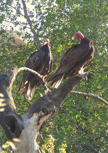
A pair of turkey vultures perch near the trail up to Stelzer Summit.
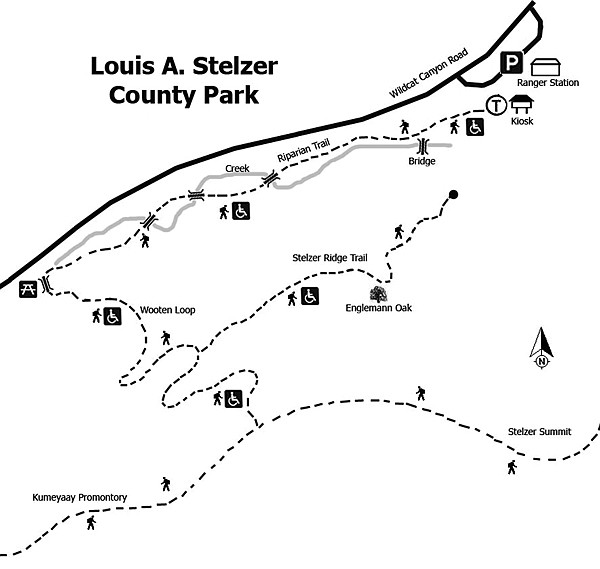
The hike begins at the entrance gate following the Riparian Trail. The first interpretive panel warns hikers to be on the lookout for poison oak. The trail is shaded by a variety of trees, including coast live oaks, sycamore, and cottonwoods. The oaks are festooned with wild grape. Other plants to note in this area include mulefat, elderberry, toyon, laurel sumac, buckwheat, pearly everlasting, jimsonweed, curly dock, and mallow. A series of small wooden bridges cross the creek. Note the colorful lichens adhering to the blocks of gabbro found on the trail. Lichen is a symbiotic relationship between an algae and a fungi. The algae manufactures the food while the fungi provides the attachment to the rock. Birds to note in this oak woodland area include acorn woodpeckers, western bluebirds, plain titmouse, and mountain chickadees. The arroyo willows in the area create nesting habitat for the endangered Bell’s least vireo.
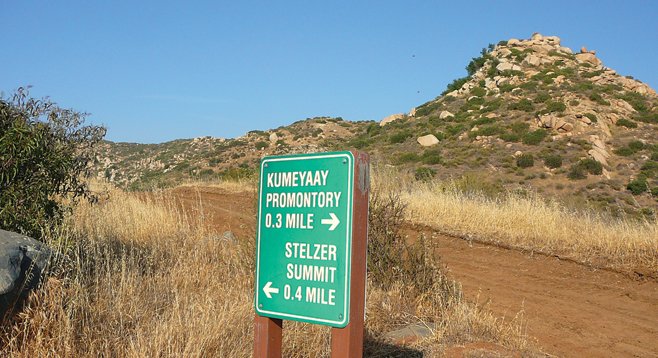
The trail abruptly turns to the left as the Wooten Loop begins and climbs up the hillside into the chaparral and surrounding meadows. At the junction with the Stelzer Trail, hikers have the choice of either cutting their hike short by turning to the left and heading 0.3 mile to the campground area or going to the right 0.24 mile up a zigzag trail to meet the Summit Trail. At the top of the Summit Trail there are two options. Follow the service road to the left 0.4 mile to the top of Stelzer Summit, the highest point in the park at 1179 feet. The climb is very steep and the view is worth the effort. The service road to the right leads to Kumeyaay Promontory, which, unfortunately, is covered with power-line towers. Plants found on the ridge include mustard, deerweed, blue dicks, buckwheat, white sage, golden stars, orange monkey flower, viguera, and laurel sumac, among others. Retrace steps back to the junction with the Stelzer Trail and follow it to the campground. Cross the campground area to return to the trailhead.
Louis Alexander Stelzer purchased the property as a private retreat in the 1940s, calling it Shadow Mountain Ranch. Upon his death in 1972, he deeded the land to the county so that children would have a place for outdoor education. The park is named in his honor and was dedicated in 1982. It became the first recreational facility in Southern California designed to accommodate visitors of all abilities. Interpretive panels are found on the trails. There is also a large camping area reserved for the use of sanctioned youth groups. Pets are permitted on a leash.
Distance from downtown San Diego: About 25 miles. Drive east on I-8 and turn north on Hwy 67, heading 8.3 miles to the signal light on Willow Road. Turn right on Willow Road and drive 0.9 mile to Wildcat Canyon Road. Turn left up Wildcat Canyon Road and drive 0.8 mile to the entrance to Louis A. Stelzer County Park on the right. Pay the $3 day-use fee and park. Facilities available. Take care in exiting the park because of heavy traffic in both directions on Wildcat Canyon Rd.
Hiking length: Almost 3 miles round trip for all trails inclusive.
Difficulty: Easy except moderately strenuous for the short climb to the peak. Total elevation gain/loss of 600 feet. Recommend trekking poles for hike to the peak – elevation gain 360 feet in 0.40 mile with loose gravel.
Here's something you might be interested in.
Louis A. Stelzer County Park Trails
Hike from a tree-shaded riparian area to a mountain peak
Louis A. Stelzer County Park Trails
Hike from a tree-shaded riparian area to a mountain peak
The varied topography and ecosystems of Louis A. Stelzer County Park make this 420-acre reserve a delight to visit. It is situated along Wildcat Canyon Creek and includes the rocky hillsides, ridgeline, and a peak with 360-degree views of the surrounding area. The topography also includes a series of small meadows. A narrowing granite-lined passage follows the creekbed where gabbro is the dominate rock. Plant communities found in the park include coastal sage scrub, chaparral, and a southern oak riparian woodland.
This park provides a good example of fire recovery. In October 2003, the Cedar Fire burned 15 percent of San Diego County and charred over 380,000 acres. Over 15,000 acres of county parklands burned, including 95 percent of Stelzer County Park. Many of the oaks in the park survived, as they are fire-adapted.
A pair of turkey vultures perch near the trail up to Stelzer Summit.
The hike begins at the entrance gate following the Riparian Trail. The first interpretive panel warns hikers to be on the lookout for poison oak. The trail is shaded by a variety of trees, including coast live oaks, sycamore, and cottonwoods. The oaks are festooned with wild grape. Other plants to note in this area include mulefat, elderberry, toyon, laurel sumac, buckwheat, pearly everlasting, jimsonweed, curly dock, and mallow. A series of small wooden bridges cross the creek. Note the colorful lichens adhering to the blocks of gabbro found on the trail. Lichen is a symbiotic relationship between an algae and a fungi. The algae manufactures the food while the fungi provides the attachment to the rock. Birds to note in this oak woodland area include acorn woodpeckers, western bluebirds, plain titmouse, and mountain chickadees. The arroyo willows in the area create nesting habitat for the endangered Bell’s least vireo.
The trail abruptly turns to the left as the Wooten Loop begins and climbs up the hillside into the chaparral and surrounding meadows. At the junction with the Stelzer Trail, hikers have the choice of either cutting their hike short by turning to the left and heading 0.3 mile to the campground area or going to the right 0.24 mile up a zigzag trail to meet the Summit Trail. At the top of the Summit Trail there are two options. Follow the service road to the left 0.4 mile to the top of Stelzer Summit, the highest point in the park at 1179 feet. The climb is very steep and the view is worth the effort. The service road to the right leads to Kumeyaay Promontory, which, unfortunately, is covered with power-line towers. Plants found on the ridge include mustard, deerweed, blue dicks, buckwheat, white sage, golden stars, orange monkey flower, viguera, and laurel sumac, among others. Retrace steps back to the junction with the Stelzer Trail and follow it to the campground. Cross the campground area to return to the trailhead.
Louis Alexander Stelzer purchased the property as a private retreat in the 1940s, calling it Shadow Mountain Ranch. Upon his death in 1972, he deeded the land to the county so that children would have a place for outdoor education. The park is named in his honor and was dedicated in 1982. It became the first recreational facility in Southern California designed to accommodate visitors of all abilities. Interpretive panels are found on the trails. There is also a large camping area reserved for the use of sanctioned youth groups. Pets are permitted on a leash.
Distance from downtown San Diego: About 25 miles. Drive east on I-8 and turn north on Hwy 67, heading 8.3 miles to the signal light on Willow Road. Turn right on Willow Road and drive 0.9 mile to Wildcat Canyon Road. Turn left up Wildcat Canyon Road and drive 0.8 mile to the entrance to Louis A. Stelzer County Park on the right. Pay the $3 day-use fee and park. Facilities available. Take care in exiting the park because of heavy traffic in both directions on Wildcat Canyon Rd.
Hiking length: Almost 3 miles round trip for all trails inclusive.
Difficulty: Easy except moderately strenuous for the short climb to the peak. Total elevation gain/loss of 600 feet. Recommend trekking poles for hike to the peak – elevation gain 360 feet in 0.40 mile with loose gravel.
Comments