Here's something you might be interested in.
Ask a Hipster — Advice you didn't know you needed
Big Screen — Movie commentary
Blurt — Music's inside track
Booze News — San Diego spirits
Classical Music — Immortal beauty
Classifieds — Free and easy
Cover Stories — Front-page features
Drinks All Around — Bartenders' drink recipes
Excerpts — Literary and spiritual excerpts
Feast! — Food & drink reviews
Feature Stories — Local news & stories
Fishing Report — What’s getting hooked from ship and shore
From the Archives — Spotlight on the past
Golden Dreams — Talk of the town
The Gonzo Report — Making the musical scene, or at least reporting from it
Letters — Our inbox
Movies@Home — Local movie buffs share favorites
Movie Reviews — Our critics' picks and pans
Musician Interviews — Up close with local artists
Neighborhood News from Stringers — Hyperlocal news
News Ticker — News & politics
Obermeyer — San Diego politics illustrated
Outdoors — Weekly changes in flora and fauna
Overheard in San Diego — Eavesdropping illustrated
Poetry — The old and the new
Reader Travel — Travel section built by travelers
Reading — The hunt for intellectuals
Roam-O-Rama — SoCal's best hiking/biking trails
San Diego Beer — Inside San Diego suds
SD on the QT — Almost factual news
Sheep and Goats — Places of worship
Special Issues — The best of
Street Style — San Diego streets have style
Surf Diego — Real stories from those braving the waves
Theater — On stage in San Diego this week
Tin Fork — Silver spoon alternative
Under the Radar — Matt Potter's undercover work
Unforgettable — Long-ago San Diego
Unreal Estate — San Diego's priciest pads
Your Week — Daily event picks
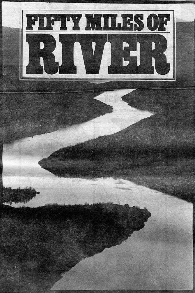
Three days along the San Dieguito River
From Volcan Mountain to the Del Mar racetrack
Though the San Dieguito River has the largest watershed in San Diego County, the river is known by so many different names that it has almost lost any identity as a river.
It was seven o’clock in the morning, cold as a dog’s nose, and I was down on my knees, crawling through the brush on Volcan Mountain, looking for something that I knew damn well didn't exist. I couldn’t have thought of a better way to spend the morning, really; it was just that I didn't like having to be so sneaky about it.
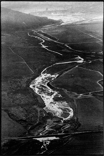
The San Pasqual Valley. In those days the river’s course was serpentine, which the dairyman H.G. Fenton thought deprived him of usable farm land. So Fenton “corrected” the problem by using bulldozers to straighten three miles of the river.
I had ditched my mountain bike in the bushes down by the locked gate at the base of Volcan Mountain and started up the hillside on foot. There were patches of sharp-smelling chinquapin that always give me sneezing fits, and thick stands of cedars and oaks. A covey of worried quail led me up a steep creek; when I got too close, they would fly on ahead.
Just about every tree on Volcan Mountain taller than eight feet has a sign tacked to it: “No Trespassing — Violators Liable To Arrest! Signed, E.C. Rutherford.” Every now and then, a pickup truck wound its way up the asphalt road across the hillside from me. I supposed it was E.C. Rutherford’s ranch hands rounding up trespassers to be hanged later in the day, after E.C had had his morning coffee. Which is why I was trying to stay hidden in the brush. I didn’t expect Mr. Rutherford to understand that I was trying to find the headwaters of the San Dieguito River. I’m sure he knew as well as anybody that there is no such place.
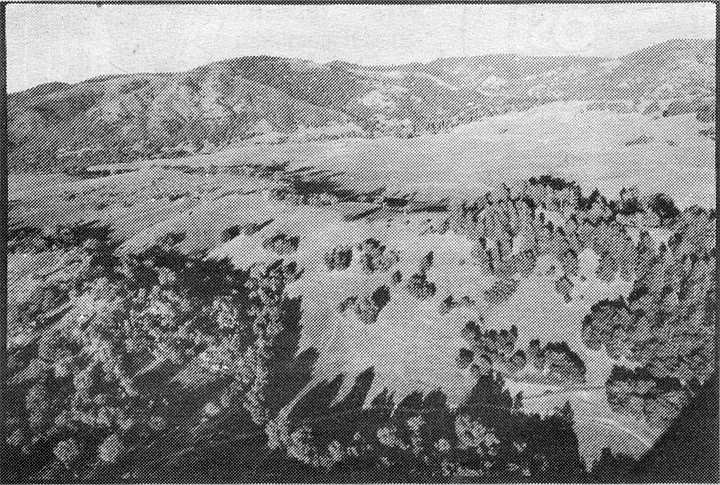
Forty miles inland, Volcan Mountain shields the river's headwaters. Just about every tree on Volcan Mountain taller than eight feet has a sign tacked to it: “No Trespassing — Violators Liable To Arrest! Signed, E.C. Rutherford.”
Though the San Dieguito River has the largest watershed in San Diego County, draining about 325 square miles through the very heart of the county, the river is known by so many different names that it has almost lost any identity as a river. Here on Volcan Mountain, for example, the river is known as Santa Ysabel Creek, or sometimes as Volcan Creek. Farther down, below Sutherland Dam, the river is called the San Pasqual. Below Lake Hodges it becomes the San Dieguito River, which was once called the San Dieguillo and the San Bernardo.
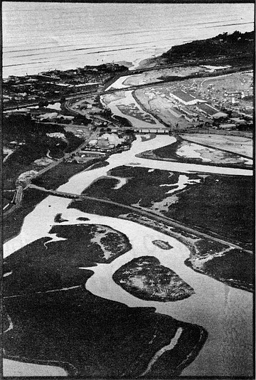
Del Mar: the river meets the sea. Here and on the other side of the river, at the Del Mar Racetrack, earth dikes have been built to protect areas that used to be flooded by the lagoon
Because of the San Dieguito River’s many confusing names, and because so much of it flows through private or inaccessible lands, it remains, if not exactly unknown, at least misunderstood. And that was why I wanted to travel the river’s fifty-mile length, by bike and on foot, to try to understand it as one unit, as an entire watershed.
But first I had to find where the damn thing started. I’d put a good deal of time into studying the problem (about ten minutes that morning) and decided that the headwaters of the San Dieguito River had to be somewhere on Volcan Mountain, on land belonging to E.C. Rutherford — though how high, I didn’t know.
When I stopped to catch my breath, I looked back and was surprised to see a view of maybe forty miles to the southwest — nearly as far as the cloud-covered coast. For spectacular scenery, there aren’t many places in this county to match Volcan Mountain. Somewhere in the distance I could hear a chain saw whining. Now and then a woodpecker chattered impatiently into the side of an oak. But other than that, and except for the sound of the creek I was following, the mountain was quiet.
After about another thirty minutes of climbing, I came to a hillside just above the main fork of Santa Ysabel Creek. There in a stand of large, graceful ferns, I found a spring gushing from the rocks. Just a few hundred feet away was another large spring. On my map, this place was called Ironside Spring. I followed the drainage up the mountainside half a mile farther, through the summer camp at Cedar Glen, to the top of Volcan Ridge; but the drainage there was dry, and if it was dry now, during a fairly wet winter, it was dry most of the year. As nearly as I could tell, the San Dieguito River began at that patch of ferns at Ironside Spring. It seemed like a good place for a river to start.
As I headed down Santa Ysabel Creek, the sun came over Volcan Mountain and warmed the western slope. I hadn’t gone far before I came upon the carcass of a 1940-era automobile, battered and rusted, riddled with bullet holes, its passenger compartment filled with leaves. I don’t know what make the car was. (It had a V-12 engine and suicide doors.) Perhaps the car had been somebody’s drunken heartbreak some dark night forty years ago, but it had been in that spot for so long now that oak trees were growing up around it, and it had begun to look like a natural part of the forest.
In the next three days, I learned that the San Dieguito River drainage is a kind of graveyard for dead automobiles. They litter the river’s canyons like dinosaur bones. That V-12 was simply the first, and perhaps the oldest, I would find.
The San Dieguito isn’t exactly what you could call a wild river. In fact, from Ironside Spring it only flows about half a mile before whatever wild notions it might have had are checked by an earthen dam. The reservoir is used to water cattle and horses on the Rutherford Ranch. Below the dam, Santa Ysabel Creek’s banks, which were once covered by native grasses, are now badly scarred and eroded by overgrazing.
I recovered my bike from the cedar thicket where I had hidden it and began the rapid descent down Orchard Lane to Wynola, and then on to the town of Santa Ysabel, thinking to myself, If all the world was downhill, I could be one helluva fast bike racer.
On Highway 79, just south of the Santa Ysabel Mission, Santa Ysabel Creek emerges from the hills and flows west across the grassy valley. The creek there is clear, the way a mountain stream should be. Willows, turning yellow with the cold winter nights, line its banks.
Before the Spanish missionaries founded the asistencia at Santa Ysabel in 1822, the Ipaay Indian women used to grind acorns on the rocks beside Santa Ysabel Creek. Their mortar holes can still be found up and down the valley. Like Mission Indians all over California, the Ipaay were converted to agriculture as much as to Christianity. Corn and wheat replaced the ancient acorn staple. But when the crops failed, or when the Spanish priests abandoned many of the missions after the Mexican Revolution, some of the Indians went back to grinding acorns. And if they ever need to go back to acorns again, the hills above the mission are still covered with oak trees, and the old mortar holes still line the rocks along the creek.
Santa Ysabel Creek drops about a thousand feet in the next five miles before it joins Witch Creek and flows into Sutherland Reservoir. Rather than following it through the Santa Ysabel Indian Reservation and the private cattle ranches, I decided to take the road to Mesa Grande, seven miles to the northwest, and pick up Scholder Creek, in Black Canyon — another tributary of the San Dieguito River.
As I rode through the warm valley, I saw there was an abundance of cottonwood trees, willows, and rushes — all indicators of a high water table. The Santa Ysabel Valley is more lush than almost any other place of its size in this dry county. It’s largely the water from this valley that fills the Sutherland Reservoir and makes up a large part of the San Dieguito watershed.
I walked my bike up the long Mesa Grande grade, past Bloomdale Creek, and past the ranches and homes of the reservation. At Mesa Grande, where there is still an old-fashioned store and gas station, I turned south, down Black Canyon. A great blue heron, perhaps startled to see a human outside of a car, flew up from a pond beside the road.
Black Canyon is one of the most beautiful, and tortured, canyons in San Diego County. Most of the land in the canyon belongs to the U.S. Forest Service and is open to the public. The dirt road through the canyon passes a hundred feet or so above the creek, giving easy access to many beautiful swimming holes along the creek bottom. But as far back as the 1950s, Black Canyon had a reputation for drunken parties, drug use, and general lawlessness. The canyon is littered with dead cars. There are many places where people have backed up to the canyon’s edge and shoveled out whole pickup loads of garbage. The forest service has practically thrown its hands up in frustration in trying to deal with the area, though sometime in the near future it will be holding public hearings to try to come up with some solutions to the problems there.
Toward the lower end of Black Canyon, Scholder Creek joins Santa Ysabel Creek. About a mile or so to the east is Sutherland Reservoir — San Diego’s lost lake. The 640-acre reservoir can’t be seen from any major highway, few people know where it is, and fewer have ever been there. Even the dam’s name seems to have been selected for its forgettableness: John P. Sutherland was a real-estate agent from Kansas who happened to own land in the area.
The history of Sutherland Dam, though, is more intriguing. The City of San Diego, which needed more water for its northward expansion to Kearny Mesa, began construction on the dam in 1927. But a flurry of political squabbling soon halted the project. It seems the city had begun the work without having first settled the issue of compensating farmers below the dam for their lost water rights. H.G. Fenton, a prosperous dairy farmer in San Pasqual, led the fight against the dam, and when the City of San Diego eventually paid the farmers about five million dollars for their water rights, Fenton alone received a million of it.
The dam was finally completed in 1954. Just a few days later, San Diego’s city manager began rallying the voters to approve a new sewer bond in the next election. “If we use water, we must dispose of it,” he said. The same vicious cycle continues today: a growing population requires more water, more water requires improved sewer capacity, improved sewer capacity allows more construction, leading to a growing population, which then requires more water.
About a mile below Sutherland Dam, there’s an old forest service campground that has been closed for several years because of vandalism. I arrived at the entrance to the campground just before dusk. The gate was locked, but I had no trouble lifting my bike over the gate and letting myself in. I rode down the steep road to the empty campground, which was quiet and peaceful, though a bit eerie without other campers. I set up a quick camp, then went down to Santa Ysabel Creek to wash.
The outflow from Sutherland Dam was little more than a trickle, but the creek bottom itself was a pleasant sight: thick stands of sycamores and alders and, oddly, a cactus here and there. I found the forelegs of a young deer, probably a mountain lion kill, not far from the creek. As I started back to my camp, the moon came up over Corral Mountain, inciting the frogs along the creek to riot. A shadow passed on the ground in front of me, and I looked up to see a large owl flying down canyon — the start of his working day.
One of the more interesting trends among environmentalists these days is the notion of bioregionalism. The term is still evolving, but one way to define it is: a hope that the Earth’s resources could be better protected if political boundaries conformed more closely to geographical boundaries. One obvious example is that counties, states, and even nations could be divided into watersheds, rather than arbitrary lines drawn by a surveyor. The problems we’re seeing now with sewage and chemical wastes flowing into the United States from Mexico by way of the Tia Juana River, and the New River in Imperial County, are two examples of the kinds of land-management dilemmas that could be avoided. National parks, forests, and wilderness would encompass entire watersheds, wherever possible, for the total management of the ecosystems within those watersheds.
Whether or not political boundaries ever do become geographical boundaries, it’s important and useful for us to think in terms of whole watersheds. It gives us a sense of where our home is and helps us define our responsibility for protecting and caring for that land.
Following the principles of watershed management, San Diego County might be divided into six and a half counties: Santa Margarita, San Luis Rey, San Dieguito, San Diego, Sweetwater, Otay, and half of Tia Juana County. (To correct that little asymmetry at the border, the U.S. could give San Ysidro and Imperial Beach to Mexico, in exchange for the polluted headwaters of the New River — though the Mexicans might not consider that a fair trade.)
Looking at San Diego’s watersheds in another way, though, we’re a bioregional freak, since ninety percent of our water is piped in from other regions. This has allowed a huge population to inhabit an area that would otherwise be a desert and as a result has brought devastating impacts upon our environment.
The next morning was warm and clear — perfect weather for a day in December. I crossed Santa Ysabel Creek and started riding down the dirt road to Pamo Valley. But I hadn’t gone more than a quarter of a mile when I came around a bend in the road and saw a striped skunk about fifty feet away, standing perfectly still. Skunks are generally nocturnal animals, and I couldn’t understand what it was doing out in broad daylight or why it didn’t run when it saw me. I put my bike down and moved a little closer.
When I was about twenty feet away, I saw that one of the skunk’s front legs was caught in a steel trap. It thrashed around briefly, trying to free itself, but the situation was hopeless.
Without going into a discussion about the ethics of fur trapping, let me say that I’m not entirely opposed to that practice. But I’ve known a lot of trappers, and I know that most of them have no use for skunks; it’s mostly coyotes and bobcats they’re after. Skunks, though, do have an annoying habit of turning up in their traps, and since there is no good way of releasing a skunk from a trap without getting sprayed, most trappers simply shoot the skunks, then release them. That had always seemed to me like a messy, wasteful way to solve the problem.
Still, if I’d had any sense at all, I’d have gone on my way. Somehow, though, I couldn’t bring myself to do it. This skunk seemed exhausted from what had probably been an all-night struggle to free itself, so I thought maybe I could release it from the trap with my boot and a good stout stick without getting bitten or sprayed. I moved a little closer — maybe fifteen feet away, no nearer — to study the situation.
As soon as I saw the skunk lift its tail, I knew I’d made a bad mistake. I jumped back, but it was already too late. A yellow, foul-smelling mist rained down on me, from the bill of my cap to the toes of my boots. It was a direct hit, not a drop wasted.
I quickly pulled off my clothes, wrapped them in two plastic bags, then went down to the creek to wash my body as best I could. I put on clean clothes, wished the skunk good luck, and went on my way.
The next several miles of Santa Ysabel Creek are exceptionally beautiful — big, colorful sycamores and deep, clear pools — but I didn’t enjoy the scenery much. I was in a hurry. Fur trappers are required by law to check their traps once a day. I knew this trapper would be along soon, and I didn’t care to meet him.
After an hour or so of hard riding, I came upon one of the most beautiful sights in San Diego County — Pamo Valley on a clear winter morning. Anybody who has ever thought that filling that valley with water is a good idea should go stand on the side of Black Mountain and look down on that gorgeous landscape. Sunny, serene, green as an alpine valley in Idaho — there’s nothing like it within 200 miles of San Diego. The argument for the dam, of course, is that we need a backup water supply in the event of a catastrophe. But the catastrophe has already happened: when 2.2 million people became dependent upon a 500-mile canal for ninety percent of their water. To build another dam so that more houses can be built in North County only perpetuates the catastrophe.
Using binoculars, I saw on the other side of the valley where the U.S. Army Corps of Engineers has already placed a row of stakes marking where the lake’s waterline will be when, or if, the Pamo Dam is built.
I followed the windy road to the bottom of the valley, stopped in the center of the wide gravel road, and looked in both directions. There wasn’t a house or a car in sight. Across the road, a Brahma bull flared its nostrils at me, then snorted and narrowed its eyes in disgust.
“I know,” I said. “It happened up the road a ways.”
Temescal Creek, which drains Pamo Valley, is about ten miles long, but the mountains to the north aren’t very high, and the creek’s entire watershed is only about thirty-five square miles. The creek was barely flowing; the water was an orange, mineral color.
At the south end of Pamo Valley, I picked up a dirt forest service road that follows Santa Ysabel Creek nearly to San Pasqual. It’s another one of those lost areas of San Diego County — forgotten by most, abused by a few.
The first mile or so of the creek looked like the day after Armageddon. There were washing machines riddled with bullet holes, old cars stripped and burned, heaps of rain-soaked pornography, plastic dolls with their heads pulled off, oak trees blasted apart by shotguns, bald mannequins with their genitals smashed ... all this in an otherwise beautiful, parklike grove beside a tranquil stream. Some of this land was privately owned, but some of it was forest Service land.
The forest service, and other land-use managers, have a real dilemma in places like Santa Ysabel Creek. Most people treat the public lands with respect, yet just a handful of sadistic lunatics can trash a place in a few hours. The public has a legitimate right of access to public lands; the forest service doesn’t have the manpower to be everywhere at all times, so, what we get is places like this war zone on Santa Ysabel Creek.
Some forest users are beginning to say the forest service should close to vehicle traffic all areas that are being abused; the areas would still be open to the public, but only to those willing to travel on foot or bicycle. Private vehicles would be allowed only when a ranger is patrolling an area. Also, the forest service could use volunteers to patrol areas during the weekends and summers — not to confront violators, but to make their presence known and, if necessary, to take down license plate numbers. With San Diego’s growing population, prime recreational areas like Black Canyon and Santa Ysabel Creek are becoming increasingly rare and valuable, and we just can’t allow them to be destroyed by a few drug-crazed, gun-happy morons.
Just a couple of miles east of San Pasqual, the forest service road I was following emerged at Highway 78.I encountered the first heavy traffic I had seen in two days, and as soon as I could, I bailed off the side of the road to ride through the avocado and citrus groves, where travel was more peaceful. I took the back way through San Pasqual, following Bandy Canyon Road. As I passed the San Pasqual Academy, flute music wafted from a second-story building, across the hay fields and orange groves.
San Pasqual has some of the largest dairy farms in the county, which, at the moment, I was particularly grateful for. There aren’t many aromas that can mask the smell of skunk. As I passed a farmer on a tractor rearranging his pile of manure, I waved happily and sucked in a deep breathful of the fine, rich air.
The San Pasqual Valley is one of the prime agricultural areas in San Diego County, with a rare combination of good soil, water, and a moderate climate. In the 1880s, wagon loads of alfalfa from San Pasqual were hauled to San Diego to feed the horses there; on top of each wagon load, the farmers would place a layer of watermelons. The journey took three days, round trip. Later, by the 1930s, San Pasqual had gone mostly to dairy farms which, along with citrus and avocado orchards, remains the valley’s major enterprise.
Unfortunately, after decades of farming, the groundwater in the San Pasqual Valley has become polluted with phosphates and chlorides, and probably pesticides as well. The San Diego County Water Authority has a complicated reclamation plan for the damaged aquifer, which includes pumping the groundwater from San Pasqual into the even more polluted San Dieguito Valley below Lake Hodges, then replenishing the groundwater in San Pasqual with secondary sewage effluent from Escondido that otherwise would be piped to the ocean. The plan seems to be a practical one; but unfortunately, for political leverage, the SDCWA is insisting the reclamation plan be tied to the Pamo Dam project. If the water authority doesn’t get Pamo Dam, it won’t do the reclamation in San Pasqual — or so it says.
Near the H.G. Fenton ranch, I took a short detour to have another look at Santa Ysabel Creek (or, if you prefer, the San Pasqual River). The creek didn’t amount to much, just a trickle among the willows. Before Sutherland Dam was built, the river would flood every winter, which not only replenished the aquifer, but carried down from the mountains the deep soils that allow the valley to be such prime agricultural land today. In those days the river’s course was serpentine, which the dairyman H.G. Fenton thought deprived him of usable farm land. So Fenton “corrected” the problem by using bulldozers to straighten three miles of the river. The correction solved his problem; but a straighter river is a swifter river, and in the long run Fenton’s efforts only caused greater flooding and increased erosion downstream, a lowering of the water table in the valley, and the destruction of wildlife habitat along the river.
That evening, about an hour before dark, I arrived at the little bar and country store at Del Dios. I went inside, sat down at the bar, and ordered a beer. I had only taken a sip or two when a couple of fellows, construction workers, came in and sat down at a table behind me. “Whew!” one of them said. “This place smells like skunk!”
I turned around on my stool. “I’ll just be a minute or two,” I said. “I really need to finish this beer.”
A Traditional Remedy For Skunk Odor
1 gallon tomato juice
2-gallon bucket
Place clothes in bucket, pour in tomato juice, leave overnight.
Below Lake Hodges, the San Dieguito River actually becomes the San Dieguito River — that is, people know it by its name. Ironically, though, it is this stretch of the river that least resembles a river. Just below the dam, the native vegetation has been crowded out by eucalyptus trees, wild tobacco, and pampas grass. The river’s flow, which wildlife once depended on, has been choked to a dirty gray dribble. The slopes above the river have been turned into tax-deductible citrus groves for the wealthy residents of Rancho Santa Fe. Most of the water for these groves is pumped from the San Dieguito aquifer, which has been so depleted that salt water from the ocean has intruded into the basin. The rocky hillsides, too steep for development, are dotted with the caves and huts of illegal aliens who work these groves.
I rode slowly down the quiet calles and avenidas, staying as close to the river as I could. A steady, down-canyon breeze pushed me toward the ocean.
At Via de Santa Fe, sand and gravel are being dredged from the river bed by the Coast Sand Company. Next to that is the Rancho Santa Fe Water Reclamation Facility. A sign posted next to the river reads: “No Hunting or Swimming. Sewer Water. Violators Will Be Prosecuted.”
Just down the road, at the Whispering Palms Golf Course, I saw the strangest sight of my three-day journey. At the boundary of the golf course, the river bed simply ends. Where the river once was, there’s now a manicured lawn and quaint little make-believe bridges. What used to be the San Dieguito River has been transformed into a landscape architect’s notion of what a gentrified river should be.
It was too eerie for me. I ignored a party of golfers and rode my bike straight on through the golf course until, thank God, I found the real river again on the other side.
Two hundred years ago, the area around Rancho Santa Fe, and what is now known as the Fairbanks Ranch, was one of the most beautiful and desirable parts of San Diego County. Father Juan Crespi described the area in his diary on July 15, 1769: “...all the land is level, very verdant, with much pasture, many wild grapes, and other herbs.... It seems that this place is near the sea, judging by our view of it as we came down the valley. The hills that surround this valley are not very high, and are all of pure earth, covered with pasture...”
An advertisement from the San Diego Daily World in February of 1873 describes what the area was like at that time: “Splendid stock ranch of San Dieguito, 5007 acres about 18 miles north of San Diego, about 2 miles from coast... there are about 2,000 acres of rich valley land, water can be had at from 5-10 feet. Rich soil, and would make good orange and fruit land. $2 per acre, 10,000 green backs will buy the whole tract.”
Douglas Fairbanks and his wife, Mary Pickford, fell in love with the San Dieguito Valley in 1926: “Both Mrs. Fairbanks and myself have toured all over California hunting a location for a country estate ... but we had to come here to find it,” the world-famous actor said. “There is so much romance and glory in this location that it is incomparable to anything we have seen here or abroad.” Mr. and Mrs. Fairbanks bought a thousand acres of the valley, planted a citrus orchard, and named it Rancho Zorro but were divorced before they ever lived there.
Fairbanks Ranch has been taken over with horse ranches now, and it boasts the only polo field south of Palm Desert. It’s also being developed more quickly than any other part of the San Dieguito Valley. Gene Klein, the former owner of the Chargers, is developing 150 acres into high-toned estates that reportedly will be priced from $545,000 to $775,000. Klein has been predicting that the area “will become the Bel-Air of San Diego County.”
At El Camino Real, I turned north and crossed the bridge over the San Dieguito River. Before the dam at Lake Hodges was built, in 1918, this portion of the valley would flood every winter. Even after the dam was built, the bridge at Highway 101 washed out several times. But the flooding also provided for a lush lagoon. During the Depression, and as recently as the 1950s, the residents of Eden Gardens, just to the north of the valley, lived on fish, lobster, duck, and pheasant from the lagoon.
Today most of the lower San Dieguito River Valley is dominated by tomato, bean, and strawberry fields. There’s no doubt the valley is superior agricultural land — mostly because the moderating influence of the ocean makes it possible to grow crops nearly year-round there. But the farming activity hasn’t been kind to the river and its lagoon. Cultivation and irrigation have increased the silt deposits in the lagoon, which is partially blocked by a rock causeway built for the railroad tracks. Without seasonal flooding, the lagoon can’t flush itself, and what was once prime bird habitat is rapidly filling with silt.
At any rate, the valley is far too valuable to remain farm land for very long, and unless something is done to set it aside as a park or preserve, it will undoubtedly end up like Mission Valley, another nightmare of mirrored office buildings reflecting traffic snarls and freeway overpasses.
At Jimmy Durante Boulevard, I again crossed the river. A strong incoming tide was causing the river to flow backward, a curious sight that gave me a good excuse to get off my bike and walk for a while. Both here and on the other side of the river, at the Del Mar Racetrack, earth dikes have been built to protect areas that used to be flooded by the lagoon — again, increasing the amount of land usable by man but reducing the bird and wildlife habitat.
In June of 1827, the Frenchman Auguste Bernard Duhaut-Cilly passed this way en route to a fiesta at San Luis Rey. He was traveling by horseback with a group of Californians from San Diego who, not wanting to be late for the fiesta, decided to ride by moonlight, taking a shortcut along the beach. Duhaut-Cilly wrote in his diary: “Seven leagues from San Diego we came to a large stream, called Estero de San Dieguito, which rushed, foaming, into the sea, its encounter with the waves making a wild, rough bar. The Californians entered boldly and unhesitatingly into this torrent; and under pain of remaining alone, I was constrained to follow them: it was not, however, without difficulty that we reached the other bank; and, though we were careful to turn our horses’ heads almost into the course of the current, we drifted all the time, and landed far below our starting point, and very near the bar, roaring two fathoms from us, as it made, almost over our heads, a threatening vault.”
At the mouth of the San Dieguito River, there’s a fine white beach that, in the summer, is popular with volleyball players. But when I arrived, there was only a lone treasure hunter, bundled in layers of coats against the brisk wind, probing the sand with his metal detector.
I climbed the cliff above the beach, thinking perhaps I could look back over some of the land I had covered in the previous three days. Across the ocean, the wind was stirring up big whitecaps as far as I could see; but when I turned around to the east, toward the Volcan Mountains, I saw that a storm had moved into the back-country, and the entire San Dieguito watershed was hidden in clouds.
Here's something you might be interested in.
Three days along the San Dieguito River
From Volcan Mountain to the Del Mar racetrack
Three days along the San Dieguito River
From Volcan Mountain to the Del Mar racetrack
Though the San Dieguito River has the largest watershed in San Diego County, the river is known by so many different names that it has almost lost any identity as a river.
It was seven o’clock in the morning, cold as a dog’s nose, and I was down on my knees, crawling through the brush on Volcan Mountain, looking for something that I knew damn well didn't exist. I couldn’t have thought of a better way to spend the morning, really; it was just that I didn't like having to be so sneaky about it.
The San Pasqual Valley. In those days the river’s course was serpentine, which the dairyman H.G. Fenton thought deprived him of usable farm land. So Fenton “corrected” the problem by using bulldozers to straighten three miles of the river.
I had ditched my mountain bike in the bushes down by the locked gate at the base of Volcan Mountain and started up the hillside on foot. There were patches of sharp-smelling chinquapin that always give me sneezing fits, and thick stands of cedars and oaks. A covey of worried quail led me up a steep creek; when I got too close, they would fly on ahead.
Just about every tree on Volcan Mountain taller than eight feet has a sign tacked to it: “No Trespassing — Violators Liable To Arrest! Signed, E.C. Rutherford.” Every now and then, a pickup truck wound its way up the asphalt road across the hillside from me. I supposed it was E.C. Rutherford’s ranch hands rounding up trespassers to be hanged later in the day, after E.C had had his morning coffee. Which is why I was trying to stay hidden in the brush. I didn’t expect Mr. Rutherford to understand that I was trying to find the headwaters of the San Dieguito River. I’m sure he knew as well as anybody that there is no such place.
Forty miles inland, Volcan Mountain shields the river's headwaters. Just about every tree on Volcan Mountain taller than eight feet has a sign tacked to it: “No Trespassing — Violators Liable To Arrest! Signed, E.C. Rutherford.”
Though the San Dieguito River has the largest watershed in San Diego County, draining about 325 square miles through the very heart of the county, the river is known by so many different names that it has almost lost any identity as a river. Here on Volcan Mountain, for example, the river is known as Santa Ysabel Creek, or sometimes as Volcan Creek. Farther down, below Sutherland Dam, the river is called the San Pasqual. Below Lake Hodges it becomes the San Dieguito River, which was once called the San Dieguillo and the San Bernardo.
Del Mar: the river meets the sea. Here and on the other side of the river, at the Del Mar Racetrack, earth dikes have been built to protect areas that used to be flooded by the lagoon
Because of the San Dieguito River’s many confusing names, and because so much of it flows through private or inaccessible lands, it remains, if not exactly unknown, at least misunderstood. And that was why I wanted to travel the river’s fifty-mile length, by bike and on foot, to try to understand it as one unit, as an entire watershed.
But first I had to find where the damn thing started. I’d put a good deal of time into studying the problem (about ten minutes that morning) and decided that the headwaters of the San Dieguito River had to be somewhere on Volcan Mountain, on land belonging to E.C. Rutherford — though how high, I didn’t know.
When I stopped to catch my breath, I looked back and was surprised to see a view of maybe forty miles to the southwest — nearly as far as the cloud-covered coast. For spectacular scenery, there aren’t many places in this county to match Volcan Mountain. Somewhere in the distance I could hear a chain saw whining. Now and then a woodpecker chattered impatiently into the side of an oak. But other than that, and except for the sound of the creek I was following, the mountain was quiet.
After about another thirty minutes of climbing, I came to a hillside just above the main fork of Santa Ysabel Creek. There in a stand of large, graceful ferns, I found a spring gushing from the rocks. Just a few hundred feet away was another large spring. On my map, this place was called Ironside Spring. I followed the drainage up the mountainside half a mile farther, through the summer camp at Cedar Glen, to the top of Volcan Ridge; but the drainage there was dry, and if it was dry now, during a fairly wet winter, it was dry most of the year. As nearly as I could tell, the San Dieguito River began at that patch of ferns at Ironside Spring. It seemed like a good place for a river to start.
As I headed down Santa Ysabel Creek, the sun came over Volcan Mountain and warmed the western slope. I hadn’t gone far before I came upon the carcass of a 1940-era automobile, battered and rusted, riddled with bullet holes, its passenger compartment filled with leaves. I don’t know what make the car was. (It had a V-12 engine and suicide doors.) Perhaps the car had been somebody’s drunken heartbreak some dark night forty years ago, but it had been in that spot for so long now that oak trees were growing up around it, and it had begun to look like a natural part of the forest.
In the next three days, I learned that the San Dieguito River drainage is a kind of graveyard for dead automobiles. They litter the river’s canyons like dinosaur bones. That V-12 was simply the first, and perhaps the oldest, I would find.
The San Dieguito isn’t exactly what you could call a wild river. In fact, from Ironside Spring it only flows about half a mile before whatever wild notions it might have had are checked by an earthen dam. The reservoir is used to water cattle and horses on the Rutherford Ranch. Below the dam, Santa Ysabel Creek’s banks, which were once covered by native grasses, are now badly scarred and eroded by overgrazing.
I recovered my bike from the cedar thicket where I had hidden it and began the rapid descent down Orchard Lane to Wynola, and then on to the town of Santa Ysabel, thinking to myself, If all the world was downhill, I could be one helluva fast bike racer.
On Highway 79, just south of the Santa Ysabel Mission, Santa Ysabel Creek emerges from the hills and flows west across the grassy valley. The creek there is clear, the way a mountain stream should be. Willows, turning yellow with the cold winter nights, line its banks.
Before the Spanish missionaries founded the asistencia at Santa Ysabel in 1822, the Ipaay Indian women used to grind acorns on the rocks beside Santa Ysabel Creek. Their mortar holes can still be found up and down the valley. Like Mission Indians all over California, the Ipaay were converted to agriculture as much as to Christianity. Corn and wheat replaced the ancient acorn staple. But when the crops failed, or when the Spanish priests abandoned many of the missions after the Mexican Revolution, some of the Indians went back to grinding acorns. And if they ever need to go back to acorns again, the hills above the mission are still covered with oak trees, and the old mortar holes still line the rocks along the creek.
Santa Ysabel Creek drops about a thousand feet in the next five miles before it joins Witch Creek and flows into Sutherland Reservoir. Rather than following it through the Santa Ysabel Indian Reservation and the private cattle ranches, I decided to take the road to Mesa Grande, seven miles to the northwest, and pick up Scholder Creek, in Black Canyon — another tributary of the San Dieguito River.
As I rode through the warm valley, I saw there was an abundance of cottonwood trees, willows, and rushes — all indicators of a high water table. The Santa Ysabel Valley is more lush than almost any other place of its size in this dry county. It’s largely the water from this valley that fills the Sutherland Reservoir and makes up a large part of the San Dieguito watershed.
I walked my bike up the long Mesa Grande grade, past Bloomdale Creek, and past the ranches and homes of the reservation. At Mesa Grande, where there is still an old-fashioned store and gas station, I turned south, down Black Canyon. A great blue heron, perhaps startled to see a human outside of a car, flew up from a pond beside the road.
Black Canyon is one of the most beautiful, and tortured, canyons in San Diego County. Most of the land in the canyon belongs to the U.S. Forest Service and is open to the public. The dirt road through the canyon passes a hundred feet or so above the creek, giving easy access to many beautiful swimming holes along the creek bottom. But as far back as the 1950s, Black Canyon had a reputation for drunken parties, drug use, and general lawlessness. The canyon is littered with dead cars. There are many places where people have backed up to the canyon’s edge and shoveled out whole pickup loads of garbage. The forest service has practically thrown its hands up in frustration in trying to deal with the area, though sometime in the near future it will be holding public hearings to try to come up with some solutions to the problems there.
Toward the lower end of Black Canyon, Scholder Creek joins Santa Ysabel Creek. About a mile or so to the east is Sutherland Reservoir — San Diego’s lost lake. The 640-acre reservoir can’t be seen from any major highway, few people know where it is, and fewer have ever been there. Even the dam’s name seems to have been selected for its forgettableness: John P. Sutherland was a real-estate agent from Kansas who happened to own land in the area.
The history of Sutherland Dam, though, is more intriguing. The City of San Diego, which needed more water for its northward expansion to Kearny Mesa, began construction on the dam in 1927. But a flurry of political squabbling soon halted the project. It seems the city had begun the work without having first settled the issue of compensating farmers below the dam for their lost water rights. H.G. Fenton, a prosperous dairy farmer in San Pasqual, led the fight against the dam, and when the City of San Diego eventually paid the farmers about five million dollars for their water rights, Fenton alone received a million of it.
The dam was finally completed in 1954. Just a few days later, San Diego’s city manager began rallying the voters to approve a new sewer bond in the next election. “If we use water, we must dispose of it,” he said. The same vicious cycle continues today: a growing population requires more water, more water requires improved sewer capacity, improved sewer capacity allows more construction, leading to a growing population, which then requires more water.
About a mile below Sutherland Dam, there’s an old forest service campground that has been closed for several years because of vandalism. I arrived at the entrance to the campground just before dusk. The gate was locked, but I had no trouble lifting my bike over the gate and letting myself in. I rode down the steep road to the empty campground, which was quiet and peaceful, though a bit eerie without other campers. I set up a quick camp, then went down to Santa Ysabel Creek to wash.
The outflow from Sutherland Dam was little more than a trickle, but the creek bottom itself was a pleasant sight: thick stands of sycamores and alders and, oddly, a cactus here and there. I found the forelegs of a young deer, probably a mountain lion kill, not far from the creek. As I started back to my camp, the moon came up over Corral Mountain, inciting the frogs along the creek to riot. A shadow passed on the ground in front of me, and I looked up to see a large owl flying down canyon — the start of his working day.
One of the more interesting trends among environmentalists these days is the notion of bioregionalism. The term is still evolving, but one way to define it is: a hope that the Earth’s resources could be better protected if political boundaries conformed more closely to geographical boundaries. One obvious example is that counties, states, and even nations could be divided into watersheds, rather than arbitrary lines drawn by a surveyor. The problems we’re seeing now with sewage and chemical wastes flowing into the United States from Mexico by way of the Tia Juana River, and the New River in Imperial County, are two examples of the kinds of land-management dilemmas that could be avoided. National parks, forests, and wilderness would encompass entire watersheds, wherever possible, for the total management of the ecosystems within those watersheds.
Whether or not political boundaries ever do become geographical boundaries, it’s important and useful for us to think in terms of whole watersheds. It gives us a sense of where our home is and helps us define our responsibility for protecting and caring for that land.
Following the principles of watershed management, San Diego County might be divided into six and a half counties: Santa Margarita, San Luis Rey, San Dieguito, San Diego, Sweetwater, Otay, and half of Tia Juana County. (To correct that little asymmetry at the border, the U.S. could give San Ysidro and Imperial Beach to Mexico, in exchange for the polluted headwaters of the New River — though the Mexicans might not consider that a fair trade.)
Looking at San Diego’s watersheds in another way, though, we’re a bioregional freak, since ninety percent of our water is piped in from other regions. This has allowed a huge population to inhabit an area that would otherwise be a desert and as a result has brought devastating impacts upon our environment.
The next morning was warm and clear — perfect weather for a day in December. I crossed Santa Ysabel Creek and started riding down the dirt road to Pamo Valley. But I hadn’t gone more than a quarter of a mile when I came around a bend in the road and saw a striped skunk about fifty feet away, standing perfectly still. Skunks are generally nocturnal animals, and I couldn’t understand what it was doing out in broad daylight or why it didn’t run when it saw me. I put my bike down and moved a little closer.
When I was about twenty feet away, I saw that one of the skunk’s front legs was caught in a steel trap. It thrashed around briefly, trying to free itself, but the situation was hopeless.
Without going into a discussion about the ethics of fur trapping, let me say that I’m not entirely opposed to that practice. But I’ve known a lot of trappers, and I know that most of them have no use for skunks; it’s mostly coyotes and bobcats they’re after. Skunks, though, do have an annoying habit of turning up in their traps, and since there is no good way of releasing a skunk from a trap without getting sprayed, most trappers simply shoot the skunks, then release them. That had always seemed to me like a messy, wasteful way to solve the problem.
Still, if I’d had any sense at all, I’d have gone on my way. Somehow, though, I couldn’t bring myself to do it. This skunk seemed exhausted from what had probably been an all-night struggle to free itself, so I thought maybe I could release it from the trap with my boot and a good stout stick without getting bitten or sprayed. I moved a little closer — maybe fifteen feet away, no nearer — to study the situation.
As soon as I saw the skunk lift its tail, I knew I’d made a bad mistake. I jumped back, but it was already too late. A yellow, foul-smelling mist rained down on me, from the bill of my cap to the toes of my boots. It was a direct hit, not a drop wasted.
I quickly pulled off my clothes, wrapped them in two plastic bags, then went down to the creek to wash my body as best I could. I put on clean clothes, wished the skunk good luck, and went on my way.
The next several miles of Santa Ysabel Creek are exceptionally beautiful — big, colorful sycamores and deep, clear pools — but I didn’t enjoy the scenery much. I was in a hurry. Fur trappers are required by law to check their traps once a day. I knew this trapper would be along soon, and I didn’t care to meet him.
After an hour or so of hard riding, I came upon one of the most beautiful sights in San Diego County — Pamo Valley on a clear winter morning. Anybody who has ever thought that filling that valley with water is a good idea should go stand on the side of Black Mountain and look down on that gorgeous landscape. Sunny, serene, green as an alpine valley in Idaho — there’s nothing like it within 200 miles of San Diego. The argument for the dam, of course, is that we need a backup water supply in the event of a catastrophe. But the catastrophe has already happened: when 2.2 million people became dependent upon a 500-mile canal for ninety percent of their water. To build another dam so that more houses can be built in North County only perpetuates the catastrophe.
Using binoculars, I saw on the other side of the valley where the U.S. Army Corps of Engineers has already placed a row of stakes marking where the lake’s waterline will be when, or if, the Pamo Dam is built.
I followed the windy road to the bottom of the valley, stopped in the center of the wide gravel road, and looked in both directions. There wasn’t a house or a car in sight. Across the road, a Brahma bull flared its nostrils at me, then snorted and narrowed its eyes in disgust.
“I know,” I said. “It happened up the road a ways.”
Temescal Creek, which drains Pamo Valley, is about ten miles long, but the mountains to the north aren’t very high, and the creek’s entire watershed is only about thirty-five square miles. The creek was barely flowing; the water was an orange, mineral color.
At the south end of Pamo Valley, I picked up a dirt forest service road that follows Santa Ysabel Creek nearly to San Pasqual. It’s another one of those lost areas of San Diego County — forgotten by most, abused by a few.
The first mile or so of the creek looked like the day after Armageddon. There were washing machines riddled with bullet holes, old cars stripped and burned, heaps of rain-soaked pornography, plastic dolls with their heads pulled off, oak trees blasted apart by shotguns, bald mannequins with their genitals smashed ... all this in an otherwise beautiful, parklike grove beside a tranquil stream. Some of this land was privately owned, but some of it was forest Service land.
The forest service, and other land-use managers, have a real dilemma in places like Santa Ysabel Creek. Most people treat the public lands with respect, yet just a handful of sadistic lunatics can trash a place in a few hours. The public has a legitimate right of access to public lands; the forest service doesn’t have the manpower to be everywhere at all times, so, what we get is places like this war zone on Santa Ysabel Creek.
Some forest users are beginning to say the forest service should close to vehicle traffic all areas that are being abused; the areas would still be open to the public, but only to those willing to travel on foot or bicycle. Private vehicles would be allowed only when a ranger is patrolling an area. Also, the forest service could use volunteers to patrol areas during the weekends and summers — not to confront violators, but to make their presence known and, if necessary, to take down license plate numbers. With San Diego’s growing population, prime recreational areas like Black Canyon and Santa Ysabel Creek are becoming increasingly rare and valuable, and we just can’t allow them to be destroyed by a few drug-crazed, gun-happy morons.
Just a couple of miles east of San Pasqual, the forest service road I was following emerged at Highway 78.I encountered the first heavy traffic I had seen in two days, and as soon as I could, I bailed off the side of the road to ride through the avocado and citrus groves, where travel was more peaceful. I took the back way through San Pasqual, following Bandy Canyon Road. As I passed the San Pasqual Academy, flute music wafted from a second-story building, across the hay fields and orange groves.
San Pasqual has some of the largest dairy farms in the county, which, at the moment, I was particularly grateful for. There aren’t many aromas that can mask the smell of skunk. As I passed a farmer on a tractor rearranging his pile of manure, I waved happily and sucked in a deep breathful of the fine, rich air.
The San Pasqual Valley is one of the prime agricultural areas in San Diego County, with a rare combination of good soil, water, and a moderate climate. In the 1880s, wagon loads of alfalfa from San Pasqual were hauled to San Diego to feed the horses there; on top of each wagon load, the farmers would place a layer of watermelons. The journey took three days, round trip. Later, by the 1930s, San Pasqual had gone mostly to dairy farms which, along with citrus and avocado orchards, remains the valley’s major enterprise.
Unfortunately, after decades of farming, the groundwater in the San Pasqual Valley has become polluted with phosphates and chlorides, and probably pesticides as well. The San Diego County Water Authority has a complicated reclamation plan for the damaged aquifer, which includes pumping the groundwater from San Pasqual into the even more polluted San Dieguito Valley below Lake Hodges, then replenishing the groundwater in San Pasqual with secondary sewage effluent from Escondido that otherwise would be piped to the ocean. The plan seems to be a practical one; but unfortunately, for political leverage, the SDCWA is insisting the reclamation plan be tied to the Pamo Dam project. If the water authority doesn’t get Pamo Dam, it won’t do the reclamation in San Pasqual — or so it says.
Near the H.G. Fenton ranch, I took a short detour to have another look at Santa Ysabel Creek (or, if you prefer, the San Pasqual River). The creek didn’t amount to much, just a trickle among the willows. Before Sutherland Dam was built, the river would flood every winter, which not only replenished the aquifer, but carried down from the mountains the deep soils that allow the valley to be such prime agricultural land today. In those days the river’s course was serpentine, which the dairyman H.G. Fenton thought deprived him of usable farm land. So Fenton “corrected” the problem by using bulldozers to straighten three miles of the river. The correction solved his problem; but a straighter river is a swifter river, and in the long run Fenton’s efforts only caused greater flooding and increased erosion downstream, a lowering of the water table in the valley, and the destruction of wildlife habitat along the river.
That evening, about an hour before dark, I arrived at the little bar and country store at Del Dios. I went inside, sat down at the bar, and ordered a beer. I had only taken a sip or two when a couple of fellows, construction workers, came in and sat down at a table behind me. “Whew!” one of them said. “This place smells like skunk!”
I turned around on my stool. “I’ll just be a minute or two,” I said. “I really need to finish this beer.”
A Traditional Remedy For Skunk Odor
1 gallon tomato juice
2-gallon bucket
Place clothes in bucket, pour in tomato juice, leave overnight.
Below Lake Hodges, the San Dieguito River actually becomes the San Dieguito River — that is, people know it by its name. Ironically, though, it is this stretch of the river that least resembles a river. Just below the dam, the native vegetation has been crowded out by eucalyptus trees, wild tobacco, and pampas grass. The river’s flow, which wildlife once depended on, has been choked to a dirty gray dribble. The slopes above the river have been turned into tax-deductible citrus groves for the wealthy residents of Rancho Santa Fe. Most of the water for these groves is pumped from the San Dieguito aquifer, which has been so depleted that salt water from the ocean has intruded into the basin. The rocky hillsides, too steep for development, are dotted with the caves and huts of illegal aliens who work these groves.
I rode slowly down the quiet calles and avenidas, staying as close to the river as I could. A steady, down-canyon breeze pushed me toward the ocean.
At Via de Santa Fe, sand and gravel are being dredged from the river bed by the Coast Sand Company. Next to that is the Rancho Santa Fe Water Reclamation Facility. A sign posted next to the river reads: “No Hunting or Swimming. Sewer Water. Violators Will Be Prosecuted.”
Just down the road, at the Whispering Palms Golf Course, I saw the strangest sight of my three-day journey. At the boundary of the golf course, the river bed simply ends. Where the river once was, there’s now a manicured lawn and quaint little make-believe bridges. What used to be the San Dieguito River has been transformed into a landscape architect’s notion of what a gentrified river should be.
It was too eerie for me. I ignored a party of golfers and rode my bike straight on through the golf course until, thank God, I found the real river again on the other side.
Two hundred years ago, the area around Rancho Santa Fe, and what is now known as the Fairbanks Ranch, was one of the most beautiful and desirable parts of San Diego County. Father Juan Crespi described the area in his diary on July 15, 1769: “...all the land is level, very verdant, with much pasture, many wild grapes, and other herbs.... It seems that this place is near the sea, judging by our view of it as we came down the valley. The hills that surround this valley are not very high, and are all of pure earth, covered with pasture...”
An advertisement from the San Diego Daily World in February of 1873 describes what the area was like at that time: “Splendid stock ranch of San Dieguito, 5007 acres about 18 miles north of San Diego, about 2 miles from coast... there are about 2,000 acres of rich valley land, water can be had at from 5-10 feet. Rich soil, and would make good orange and fruit land. $2 per acre, 10,000 green backs will buy the whole tract.”
Douglas Fairbanks and his wife, Mary Pickford, fell in love with the San Dieguito Valley in 1926: “Both Mrs. Fairbanks and myself have toured all over California hunting a location for a country estate ... but we had to come here to find it,” the world-famous actor said. “There is so much romance and glory in this location that it is incomparable to anything we have seen here or abroad.” Mr. and Mrs. Fairbanks bought a thousand acres of the valley, planted a citrus orchard, and named it Rancho Zorro but were divorced before they ever lived there.
Fairbanks Ranch has been taken over with horse ranches now, and it boasts the only polo field south of Palm Desert. It’s also being developed more quickly than any other part of the San Dieguito Valley. Gene Klein, the former owner of the Chargers, is developing 150 acres into high-toned estates that reportedly will be priced from $545,000 to $775,000. Klein has been predicting that the area “will become the Bel-Air of San Diego County.”
At El Camino Real, I turned north and crossed the bridge over the San Dieguito River. Before the dam at Lake Hodges was built, in 1918, this portion of the valley would flood every winter. Even after the dam was built, the bridge at Highway 101 washed out several times. But the flooding also provided for a lush lagoon. During the Depression, and as recently as the 1950s, the residents of Eden Gardens, just to the north of the valley, lived on fish, lobster, duck, and pheasant from the lagoon.
Today most of the lower San Dieguito River Valley is dominated by tomato, bean, and strawberry fields. There’s no doubt the valley is superior agricultural land — mostly because the moderating influence of the ocean makes it possible to grow crops nearly year-round there. But the farming activity hasn’t been kind to the river and its lagoon. Cultivation and irrigation have increased the silt deposits in the lagoon, which is partially blocked by a rock causeway built for the railroad tracks. Without seasonal flooding, the lagoon can’t flush itself, and what was once prime bird habitat is rapidly filling with silt.
At any rate, the valley is far too valuable to remain farm land for very long, and unless something is done to set it aside as a park or preserve, it will undoubtedly end up like Mission Valley, another nightmare of mirrored office buildings reflecting traffic snarls and freeway overpasses.
At Jimmy Durante Boulevard, I again crossed the river. A strong incoming tide was causing the river to flow backward, a curious sight that gave me a good excuse to get off my bike and walk for a while. Both here and on the other side of the river, at the Del Mar Racetrack, earth dikes have been built to protect areas that used to be flooded by the lagoon — again, increasing the amount of land usable by man but reducing the bird and wildlife habitat.
In June of 1827, the Frenchman Auguste Bernard Duhaut-Cilly passed this way en route to a fiesta at San Luis Rey. He was traveling by horseback with a group of Californians from San Diego who, not wanting to be late for the fiesta, decided to ride by moonlight, taking a shortcut along the beach. Duhaut-Cilly wrote in his diary: “Seven leagues from San Diego we came to a large stream, called Estero de San Dieguito, which rushed, foaming, into the sea, its encounter with the waves making a wild, rough bar. The Californians entered boldly and unhesitatingly into this torrent; and under pain of remaining alone, I was constrained to follow them: it was not, however, without difficulty that we reached the other bank; and, though we were careful to turn our horses’ heads almost into the course of the current, we drifted all the time, and landed far below our starting point, and very near the bar, roaring two fathoms from us, as it made, almost over our heads, a threatening vault.”
At the mouth of the San Dieguito River, there’s a fine white beach that, in the summer, is popular with volleyball players. But when I arrived, there was only a lone treasure hunter, bundled in layers of coats against the brisk wind, probing the sand with his metal detector.
I climbed the cliff above the beach, thinking perhaps I could look back over some of the land I had covered in the previous three days. Across the ocean, the wind was stirring up big whitecaps as far as I could see; but when I turned around to the east, toward the Volcan Mountains, I saw that a storm had moved into the back-country, and the entire San Dieguito watershed was hidden in clouds.
Comments