Here's something you might be interested in.
Ask a Hipster — Advice you didn't know you needed
Big Screen — Movie commentary
Blurt — Music's inside track
Booze News — San Diego spirits
Classical Music — Immortal beauty
Classifieds — Free and easy
Cover Stories — Front-page features
Drinks All Around — Bartenders' drink recipes
Excerpts — Literary and spiritual excerpts
Feast! — Food & drink reviews
Feature Stories — Local news & stories
Fishing Report — What’s getting hooked from ship and shore
From the Archives — Spotlight on the past
Golden Dreams — Talk of the town
The Gonzo Report — Making the musical scene, or at least reporting from it
Letters — Our inbox
Movies@Home — Local movie buffs share favorites
Movie Reviews — Our critics' picks and pans
Musician Interviews — Up close with local artists
Neighborhood News from Stringers — Hyperlocal news
News Ticker — News & politics
Obermeyer — San Diego politics illustrated
Outdoors — Weekly changes in flora and fauna
Overheard in San Diego — Eavesdropping illustrated
Poetry — The old and the new
Reader Travel — Travel section built by travelers
Reading — The hunt for intellectuals
Roam-O-Rama — SoCal's best hiking/biking trails
San Diego Beer — Inside San Diego suds
SD on the QT — Almost factual news
Sheep and Goats — Places of worship
Special Issues — The best of
Street Style — San Diego streets have style
Surf Diego — Real stories from those braving the waves
Theater — On stage in San Diego this week
Tin Fork — Silver spoon alternative
Under the Radar — Matt Potter's undercover work
Unforgettable — Long-ago San Diego
Unreal Estate — San Diego's priciest pads
Your Week — Daily event picks
A variety of challenges for weekend hiking warriors
Climbing high into the chaparraled, boulder-frosted hills at the east end of San Pasqual Valley, the San Dieguito River Park's San Pasqual/Clevenger Canyon trail system offers a variety of challenges for weekend hiking warriors. In the early 1990s the trails here were rather hastily carved out of a patchwork of public lands that had recently been incorporated into the emerging San Dieguito River Park. Since then, the rapid regrowth of vegetation following wildSan Dieguito River Park's San Pasqual/Clevenger Canyon trail system takes hikers to heights overlooking inland North County.fires has obliterated some of the outermost trails, especially in the north section of the trail system, which is profiled here.
You'll find the trailhead on the north side of Highway 78 at 5.6 miles east of the Wild Animal Park and 2.6 miles east of Bandy Canyon Road. When headed east on 78, the turnoff comes unexpectedly; it is 0.3 mile beyond the parking lot for the south trail system.
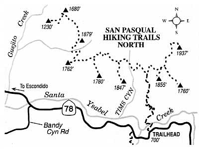
The initial 0.3-mile stretch of trail slanting down to the oak- and sycamore-shaded bank of Santa Ysabel Creek is easy enough. Fording the creek to get to the other side, though, could be problematical or downright dangerous. That depends solely on the water flow, which is normally indolent, but occasionally (in a wet year) powerful.
Beyond the Santa Ysabel Creek crossing, the narrowing trail ascends in a zigzag pattern up the hillside, and the view west toward San Pasqual Valley and the coast gets ever better and ever wider. You come to a trail junction about 2.5 miles from the creek crossing, about 1300 feet higher in elevation. At the trail fork there, decide where you want to go: right toward any of three viewpoints, or left toward any of six viewpoints. You aren't likely to get very far in any short period of time by either route, since most of this upper part of the trail system has been sorely neglected in the past decade. Emergent chaparral vegetation has a way of knitting itself together very quickly following a fire.
This article contains information about a publicly owned recreation or wilderness area. Trails and pathways are not necessarily marked. Conditions can change rapidly. Hikers should be properly equipped and have safety and navigational skills. The Reader and Jerry Schad assume no responsibility for any detrimental experience.
Here's something you might be interested in.
A variety of challenges for weekend hiking warriors
A variety of challenges for weekend hiking warriors
Climbing high into the chaparraled, boulder-frosted hills at the east end of San Pasqual Valley, the San Dieguito River Park's San Pasqual/Clevenger Canyon trail system offers a variety of challenges for weekend hiking warriors. In the early 1990s the trails here were rather hastily carved out of a patchwork of public lands that had recently been incorporated into the emerging San Dieguito River Park. Since then, the rapid regrowth of vegetation following wildSan Dieguito River Park's San Pasqual/Clevenger Canyon trail system takes hikers to heights overlooking inland North County.fires has obliterated some of the outermost trails, especially in the north section of the trail system, which is profiled here.
You'll find the trailhead on the north side of Highway 78 at 5.6 miles east of the Wild Animal Park and 2.6 miles east of Bandy Canyon Road. When headed east on 78, the turnoff comes unexpectedly; it is 0.3 mile beyond the parking lot for the south trail system.
The initial 0.3-mile stretch of trail slanting down to the oak- and sycamore-shaded bank of Santa Ysabel Creek is easy enough. Fording the creek to get to the other side, though, could be problematical or downright dangerous. That depends solely on the water flow, which is normally indolent, but occasionally (in a wet year) powerful.
Beyond the Santa Ysabel Creek crossing, the narrowing trail ascends in a zigzag pattern up the hillside, and the view west toward San Pasqual Valley and the coast gets ever better and ever wider. You come to a trail junction about 2.5 miles from the creek crossing, about 1300 feet higher in elevation. At the trail fork there, decide where you want to go: right toward any of three viewpoints, or left toward any of six viewpoints. You aren't likely to get very far in any short period of time by either route, since most of this upper part of the trail system has been sorely neglected in the past decade. Emergent chaparral vegetation has a way of knitting itself together very quickly following a fire.
This article contains information about a publicly owned recreation or wilderness area. Trails and pathways are not necessarily marked. Conditions can change rapidly. Hikers should be properly equipped and have safety and navigational skills. The Reader and Jerry Schad assume no responsibility for any detrimental experience.
Comments