Here's something you might be interested in.
Ask a Hipster — Advice you didn't know you needed
Big Screen — Movie commentary
Blurt — Music's inside track
Booze News — San Diego spirits
Classical Music — Immortal beauty
Classifieds — Free and easy
Cover Stories — Front-page features
Drinks All Around — Bartenders' drink recipes
Excerpts — Literary and spiritual excerpts
Feast! — Food & drink reviews
Feature Stories — Local news & stories
Fishing Report — What’s getting hooked from ship and shore
From the Archives — Spotlight on the past
Golden Dreams — Talk of the town
The Gonzo Report — Making the musical scene, or at least reporting from it
Letters — Our inbox
Movies@Home — Local movie buffs share favorites
Movie Reviews — Our critics' picks and pans
Musician Interviews — Up close with local artists
Neighborhood News from Stringers — Hyperlocal news
News Ticker — News & politics
Obermeyer — San Diego politics illustrated
Outdoors — Weekly changes in flora and fauna
Overheard in San Diego — Eavesdropping illustrated
Poetry — The old and the new
Reader Travel — Travel section built by travelers
Reading — The hunt for intellectuals
Roam-O-Rama — SoCal's best hiking/biking trails
San Diego Beer — Inside San Diego suds
SD on the QT — Almost factual news
Sheep and Goats — Places of worship
Special Issues — The best of
Street Style — San Diego streets have style
Surf Diego — Real stories from those braving the waves
Theater — On stage in San Diego this week
Tin Fork — Silver spoon alternative
Under the Radar — Matt Potter's undercover work
Unforgettable — Long-ago San Diego
Unreal Estate — San Diego's priciest pads
Your Week — Daily event picks
Watch out for horse pies on Dead Horse Trail
This technically advanced riding trail is also a challenge for hikers.
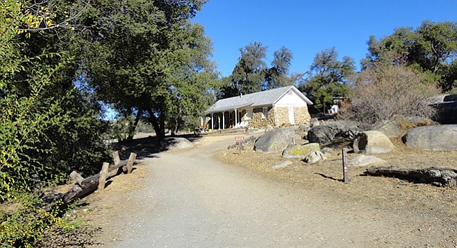
Dead Horse Trail — Pass the ranger's house to the left
Merigan Fire Road was the main road for a ranch owned by Dr. Haig Merigan, a pharmacist and dentist. His family lived and rode horses in La Mesa until it became difficult to ride due to suburban development. In 1958, Dr. Merigan purchased Oliver Ranch for a weekend retreat where they moved their horses to continue riding. He donated 1,823 acres to California State Parks in 1977 with the hope that it would have an equestrian facility.
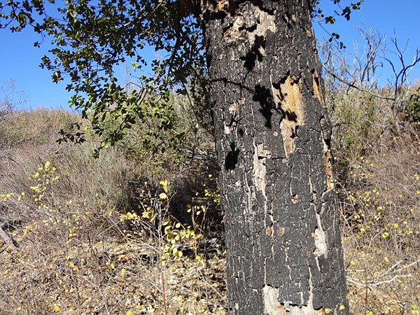
A 2003 Cedar Fire survivor along Dead Horse Trail
According to Cuyamaca Rancho State Park, Dead Horse Trail is considered a technically advanced riding trail that crosses the Sweetwater River and climbs up rocky chaparral with a 700 feet elevation gain. Riders on the trail confirmed that only their best horses are ridden on this difficult trail. Horses have the absolute right of way, followed by hikers and then bicyclists. Trail etiquette for hikers and bikers is to move to one side of the trail and not make sudden moves while the horseback riders pass.
Start from the Merigan parking lot then proceed north/northwest in front of the ranger’s house into a broad meadow. As the road rises there are shells of burnt out oak trees, victims of the 2003 Cedar Fire. Further are baccharis bush, chamise (greasewood) and plenty of poison oak. At about 0.07 mile look for signs on the left pointing to a gorge on the Sweetwater River with two viewing points. This is not very far so take advantage of the views.
Dead Horse Trail makes a steep descent and crosses the Sweetwater River. It may take extra time to cross the river if there are recent rains. Be alert here for a narrow wooden post that directs you up the trail heading west on the Dead Horse Trail. A horse trail is just that – a trail carved out by long-term horse usage. This means that the trail is narrow and deep, dipping down 12-18 inches. The challenge for the hiker on a horse trail is staying focused on where to walk. Because of the narrow width and depth, the hiker is forced to walk by placing one foot in front of the other because there is no room for both feet side by side.
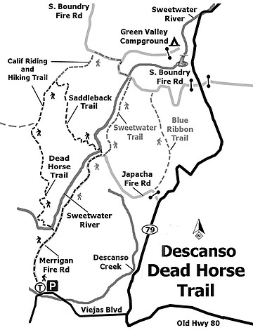
Dead Horse Trail Map
As the trail ascends the rocky chaparral face heading west, pay close attention to cairns that mark the direction of the trail so as not to head in the wrong direction. The trail climbs for about 2.4 miles around the west side, out of sight from the gorge into plush thickets of ceanothus, chamise, and mountain mahogany, major indicators of California’s chaparral community with occasional views into Viejas Valley.
Approximately 2.4 miles from the gorge crossing, Dead Horse Trail intersects the California Riding and Hiking Trail (CRHT). This is a wide multiple purpose road – hiking, riding, mountain biking, and fire. Proceed northerly up the CRHT for about 0.08 mile and turn right/southeast onto Saddleback Trail. Saddleback is another horse trail that drops through alders and willows crossing over the Sweetwater River. Again, take note of the time of year and any recent rains because at times this can be impassable; if this occurs the only option is to reverse your route back to Merigan. Saddleback is a pretty trail as it drops down through hardwoods and small meadows to the Sweetwater Crossing. At the 1.6-mile mark, it connects with the Merigan Fire Road again. There is a convergence of four trails: Saddleback, Sweetwater, Merigan East, and Merigan South. Locals call this “The Wagon Wheel” because on a map the four trails converge into an X-intersection.
This is a pleasant pine grove that is flat and easy after Saddleback’s horse trail drop. This might be a good spot to stop and relax with the smell of pines and sound of acorn woodpeckers. They are easy to identify with their black, white, and red markers and their distinctive, “wacha, wacha” calls to each other. The trip back to the Merigan parking lot is a downhill descent of about 2 miles – pleasant after the previous five miles. Be alert on the walk down as there is a pair of resident California foxes who seem unphased by hikers.
Dead Horse Trail
Distance from downtown San Diego: 40 miles (Descanso). Allow 45 minutes driving time. Take I-8 east then exit onto S-79 north for 2.7 miles before turning left to stay on S-79. Take another left (0.2 mile) onto Viejas Boulevard and drive approximately 1.1 miles before turning right into the Merigan Fire Road parking lot. This is a large parking lot with room for horse trailers and port-a-potties. The trailhead is on the northwest end of the parking lot. Note: A day-use permit is required with envelopes available in the parking lot (bring $5s and $1s as cost has changed over time).
Hiking Length: Approximately 7.5 miles.
Difficulty: Moderate to difficult with close to 700 feet of elevation gain/loss.
Here's something you might be interested in.
Watch out for horse pies on Dead Horse Trail
This technically advanced riding trail is also a challenge for hikers.
Watch out for horse pies on Dead Horse Trail
This technically advanced riding trail is also a challenge for hikers.
Dead Horse Trail — Pass the ranger's house to the left
Merigan Fire Road was the main road for a ranch owned by Dr. Haig Merigan, a pharmacist and dentist. His family lived and rode horses in La Mesa until it became difficult to ride due to suburban development. In 1958, Dr. Merigan purchased Oliver Ranch for a weekend retreat where they moved their horses to continue riding. He donated 1,823 acres to California State Parks in 1977 with the hope that it would have an equestrian facility.
A 2003 Cedar Fire survivor along Dead Horse Trail
According to Cuyamaca Rancho State Park, Dead Horse Trail is considered a technically advanced riding trail that crosses the Sweetwater River and climbs up rocky chaparral with a 700 feet elevation gain. Riders on the trail confirmed that only their best horses are ridden on this difficult trail. Horses have the absolute right of way, followed by hikers and then bicyclists. Trail etiquette for hikers and bikers is to move to one side of the trail and not make sudden moves while the horseback riders pass.
Start from the Merigan parking lot then proceed north/northwest in front of the ranger’s house into a broad meadow. As the road rises there are shells of burnt out oak trees, victims of the 2003 Cedar Fire. Further are baccharis bush, chamise (greasewood) and plenty of poison oak. At about 0.07 mile look for signs on the left pointing to a gorge on the Sweetwater River with two viewing points. This is not very far so take advantage of the views.
Dead Horse Trail makes a steep descent and crosses the Sweetwater River. It may take extra time to cross the river if there are recent rains. Be alert here for a narrow wooden post that directs you up the trail heading west on the Dead Horse Trail. A horse trail is just that – a trail carved out by long-term horse usage. This means that the trail is narrow and deep, dipping down 12-18 inches. The challenge for the hiker on a horse trail is staying focused on where to walk. Because of the narrow width and depth, the hiker is forced to walk by placing one foot in front of the other because there is no room for both feet side by side.
Dead Horse Trail Map
As the trail ascends the rocky chaparral face heading west, pay close attention to cairns that mark the direction of the trail so as not to head in the wrong direction. The trail climbs for about 2.4 miles around the west side, out of sight from the gorge into plush thickets of ceanothus, chamise, and mountain mahogany, major indicators of California’s chaparral community with occasional views into Viejas Valley.
Approximately 2.4 miles from the gorge crossing, Dead Horse Trail intersects the California Riding and Hiking Trail (CRHT). This is a wide multiple purpose road – hiking, riding, mountain biking, and fire. Proceed northerly up the CRHT for about 0.08 mile and turn right/southeast onto Saddleback Trail. Saddleback is another horse trail that drops through alders and willows crossing over the Sweetwater River. Again, take note of the time of year and any recent rains because at times this can be impassable; if this occurs the only option is to reverse your route back to Merigan. Saddleback is a pretty trail as it drops down through hardwoods and small meadows to the Sweetwater Crossing. At the 1.6-mile mark, it connects with the Merigan Fire Road again. There is a convergence of four trails: Saddleback, Sweetwater, Merigan East, and Merigan South. Locals call this “The Wagon Wheel” because on a map the four trails converge into an X-intersection.
This is a pleasant pine grove that is flat and easy after Saddleback’s horse trail drop. This might be a good spot to stop and relax with the smell of pines and sound of acorn woodpeckers. They are easy to identify with their black, white, and red markers and their distinctive, “wacha, wacha” calls to each other. The trip back to the Merigan parking lot is a downhill descent of about 2 miles – pleasant after the previous five miles. Be alert on the walk down as there is a pair of resident California foxes who seem unphased by hikers.
Dead Horse Trail
Distance from downtown San Diego: 40 miles (Descanso). Allow 45 minutes driving time. Take I-8 east then exit onto S-79 north for 2.7 miles before turning left to stay on S-79. Take another left (0.2 mile) onto Viejas Boulevard and drive approximately 1.1 miles before turning right into the Merigan Fire Road parking lot. This is a large parking lot with room for horse trailers and port-a-potties. The trailhead is on the northwest end of the parking lot. Note: A day-use permit is required with envelopes available in the parking lot (bring $5s and $1s as cost has changed over time).
Hiking Length: Approximately 7.5 miles.
Difficulty: Moderate to difficult with close to 700 feet of elevation gain/loss.
Comments