Here's something you might be interested in.
Ask a Hipster — Advice you didn't know you needed
Big Screen — Movie commentary
Blurt — Music's inside track
Booze News — San Diego spirits
Classical Music — Immortal beauty
Classifieds — Free and easy
Cover Stories — Front-page features
Drinks All Around — Bartenders' drink recipes
Excerpts — Literary and spiritual excerpts
Feast! — Food & drink reviews
Feature Stories — Local news & stories
Fishing Report — What’s getting hooked from ship and shore
From the Archives — Spotlight on the past
Golden Dreams — Talk of the town
The Gonzo Report — Making the musical scene, or at least reporting from it
Letters — Our inbox
Movies@Home — Local movie buffs share favorites
Movie Reviews — Our critics' picks and pans
Musician Interviews — Up close with local artists
Neighborhood News from Stringers — Hyperlocal news
News Ticker — News & politics
Obermeyer — San Diego politics illustrated
Outdoors — Weekly changes in flora and fauna
Overheard in San Diego — Eavesdropping illustrated
Poetry — The old and the new
Reader Travel — Travel section built by travelers
Reading — The hunt for intellectuals
Roam-O-Rama — SoCal's best hiking/biking trails
San Diego Beer — Inside San Diego suds
SD on the QT — Almost factual news
Sheep and Goats — Places of worship
Special Issues — The best of
Street Style — San Diego streets have style
Surf Diego — Real stories from those braving the waves
Theater — On stage in San Diego this week
Tin Fork — Silver spoon alternative
Under the Radar — Matt Potter's undercover work
Unforgettable — Long-ago San Diego
Unreal Estate — San Diego's priciest pads
Your Week — Daily event picks
A lasso-shaped hike with options for distance and terrain
Poison oak awaits the unwary hiker in Descanso
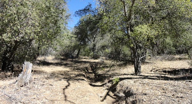
Sweetwater Trail horse path. Step to one side and no sudden movements while horses and riders pass — comprende?
The Descanso Sweetwater River Loop is a lasso-shaped hike that follows the Merigan Fire Road and then turns left onto the Saddleback Trail to start the loop. Make right turns onto the California Riding & Hiking Trail (CRHT), South Boundary Fire Road, and the Sweetwater Trail. The loop is completed where the Sweetwater Trail ends at the intersection of Saddleback Trail and the Merigan Fire Road. Take the Merigan Fire Road southwest, which initially follows the Sweetwater River, to return to the parking lot.
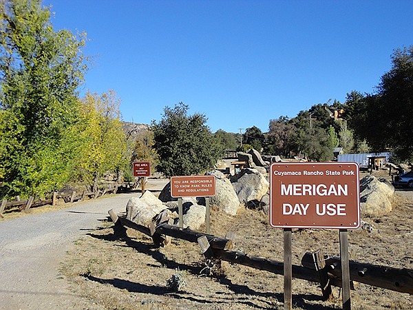
Find the trailhead in the northwest corner of the parking lot.
The hike starts at the northwest end of the parking lot. Keep to the left past the houses on the Merigan Fire Road on the eastern edge of a sunny mountain meadow, making a gradual climb into the oak forest that shows the impact of recent fires on some of the oaks. Along trailside are baccharis bushes and chamise with an abundance of poison oak waiting for the unwary hiker. At about 0.7-mile, continue on the Merigan Fire Road, bypassing Dead Horse Trail on the left. The Sweetwater River Gorge should now be coming into view west of the road. The lighter green vegetation of the riparian habitat is obvious, as alders, willows, cottonwoods, and sycamores grow near the river. There is a continual incline for about 1.9 miles from the parking lot, making this section before starting the loop moderately strenuous.
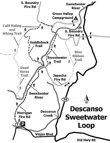
Trail map, Sweetwater River Loop
The top of the fire trail opens up into a nicely shaded flat area to what locals call the Wagon Wheel because the X-intersection offers some interesting options for hiking. There is a choice of three trails at this intersection. Turn left onto the Saddleback Trail where it shortly crosses the river. The trail offers small meadows and chaparral and oak groves. This is primarily a horse trail, as indicated by the deep ruts, but it is easily walked. Upon reaching the CRHT, turn right and then turn right again onto the South Boundary Fire Road. Then make another right turn to continue on the fire road. Cross the Sweetwater River to make another right onto the Sweetwater Trail. Continue south on the Sweetwater Trail until closing the approximately 5.3-mile loop at the X intersection. Cross over and continue back down the Merigan Fire Road to the parking lot to complete the hike.
The first option for a different hike starts at the Dead Horse Trail where it branches left across the river, rising westerly up on the next ridge. This creates a difficult varying-terrain ten-mile loop by continuing on to the CRHT and bypassing the Saddleback Trail. Turn right onto the South Boundary Fire Road, then another right to stay on the fire road before turning right again on Sweetwater Trail; then turn south onto the Merigan Fire Road to head to the parking lot.
The second option is to take a sharp right at the X intersection where the fire road turns southeast for a time before turning north onto the Blue Ribbon Trail. This trail is within sight of SR-79 and is a bit longer but not as steep. Turn left onto the South Boundary Fire Road, then another left onto Sweetwater Trail, and return to the Merigan Fire Road.
Note: Trail etiquette for hikers is to move to one side of the trail and not make sudden moves while the horseback riders pass.
DESCANSO SWEETWATER RIVER LOOP
Distance from downtown San Diego: 40 miles (Descanso). Allow 45 minutes driving time. Take I-8 east, then exit onto SR-79 north for 2.7 miles before turning left to stay on SR-79 (and off Old Highway 80). Take first left (0.2 mile) onto Viejas Boulevard and drive approximately 1.1 miles before turning right into the Merigan Fire Road parking lot. This is a large parking lot with room for horse trailers and port-a-potties. The trailhead is on the northwest end of the parking lot.
Note: A day-use permit is required.
Hike Length: Approximately 7.5 miles.
Difficulty: Difficult, with elevation gain/loss of 700 feet.
Here's something you might be interested in.
A lasso-shaped hike with options for distance and terrain
Poison oak awaits the unwary hiker in Descanso
A lasso-shaped hike with options for distance and terrain
Poison oak awaits the unwary hiker in Descanso
Sweetwater Trail horse path. Step to one side and no sudden movements while horses and riders pass — comprende?
The Descanso Sweetwater River Loop is a lasso-shaped hike that follows the Merigan Fire Road and then turns left onto the Saddleback Trail to start the loop. Make right turns onto the California Riding & Hiking Trail (CRHT), South Boundary Fire Road, and the Sweetwater Trail. The loop is completed where the Sweetwater Trail ends at the intersection of Saddleback Trail and the Merigan Fire Road. Take the Merigan Fire Road southwest, which initially follows the Sweetwater River, to return to the parking lot.
Find the trailhead in the northwest corner of the parking lot.
The hike starts at the northwest end of the parking lot. Keep to the left past the houses on the Merigan Fire Road on the eastern edge of a sunny mountain meadow, making a gradual climb into the oak forest that shows the impact of recent fires on some of the oaks. Along trailside are baccharis bushes and chamise with an abundance of poison oak waiting for the unwary hiker. At about 0.7-mile, continue on the Merigan Fire Road, bypassing Dead Horse Trail on the left. The Sweetwater River Gorge should now be coming into view west of the road. The lighter green vegetation of the riparian habitat is obvious, as alders, willows, cottonwoods, and sycamores grow near the river. There is a continual incline for about 1.9 miles from the parking lot, making this section before starting the loop moderately strenuous.
Trail map, Sweetwater River Loop
The top of the fire trail opens up into a nicely shaded flat area to what locals call the Wagon Wheel because the X-intersection offers some interesting options for hiking. There is a choice of three trails at this intersection. Turn left onto the Saddleback Trail where it shortly crosses the river. The trail offers small meadows and chaparral and oak groves. This is primarily a horse trail, as indicated by the deep ruts, but it is easily walked. Upon reaching the CRHT, turn right and then turn right again onto the South Boundary Fire Road. Then make another right turn to continue on the fire road. Cross the Sweetwater River to make another right onto the Sweetwater Trail. Continue south on the Sweetwater Trail until closing the approximately 5.3-mile loop at the X intersection. Cross over and continue back down the Merigan Fire Road to the parking lot to complete the hike.
The first option for a different hike starts at the Dead Horse Trail where it branches left across the river, rising westerly up on the next ridge. This creates a difficult varying-terrain ten-mile loop by continuing on to the CRHT and bypassing the Saddleback Trail. Turn right onto the South Boundary Fire Road, then another right to stay on the fire road before turning right again on Sweetwater Trail; then turn south onto the Merigan Fire Road to head to the parking lot.
The second option is to take a sharp right at the X intersection where the fire road turns southeast for a time before turning north onto the Blue Ribbon Trail. This trail is within sight of SR-79 and is a bit longer but not as steep. Turn left onto the South Boundary Fire Road, then another left onto Sweetwater Trail, and return to the Merigan Fire Road.
Note: Trail etiquette for hikers is to move to one side of the trail and not make sudden moves while the horseback riders pass.
DESCANSO SWEETWATER RIVER LOOP
Distance from downtown San Diego: 40 miles (Descanso). Allow 45 minutes driving time. Take I-8 east, then exit onto SR-79 north for 2.7 miles before turning left to stay on SR-79 (and off Old Highway 80). Take first left (0.2 mile) onto Viejas Boulevard and drive approximately 1.1 miles before turning right into the Merigan Fire Road parking lot. This is a large parking lot with room for horse trailers and port-a-potties. The trailhead is on the northwest end of the parking lot.
Note: A day-use permit is required.
Hike Length: Approximately 7.5 miles.
Difficulty: Difficult, with elevation gain/loss of 700 feet.
Comments