Here's something you might be interested in.
Ask a Hipster — Advice you didn't know you needed
Big Screen — Movie commentary
Blurt — Music's inside track
Booze News — San Diego spirits
Classical Music — Immortal beauty
Classifieds — Free and easy
Cover Stories — Front-page features
Drinks All Around — Bartenders' drink recipes
Excerpts — Literary and spiritual excerpts
Feast! — Food & drink reviews
Feature Stories — Local news & stories
Fishing Report — What’s getting hooked from ship and shore
From the Archives — Spotlight on the past
Golden Dreams — Talk of the town
The Gonzo Report — Making the musical scene, or at least reporting from it
Letters — Our inbox
Movies@Home — Local movie buffs share favorites
Movie Reviews — Our critics' picks and pans
Musician Interviews — Up close with local artists
Neighborhood News from Stringers — Hyperlocal news
News Ticker — News & politics
Obermeyer — San Diego politics illustrated
Outdoors — Weekly changes in flora and fauna
Overheard in San Diego — Eavesdropping illustrated
Poetry — The old and the new
Reader Travel — Travel section built by travelers
Reading — The hunt for intellectuals
Roam-O-Rama — SoCal's best hiking/biking trails
San Diego Beer — Inside San Diego suds
SD on the QT — Almost factual news
Sheep and Goats — Places of worship
Special Issues — The best of
Street Style — San Diego streets have style
Surf Diego — Real stories from those braving the waves
Theater — On stage in San Diego this week
Tin Fork — Silver spoon alternative
Under the Radar — Matt Potter's undercover work
Unforgettable — Long-ago San Diego
Unreal Estate — San Diego's priciest pads
Your Week — Daily event picks
Rare oak dots the hike to Eagle Peak
This hike has breathtaking views of the San Diego River Gorge
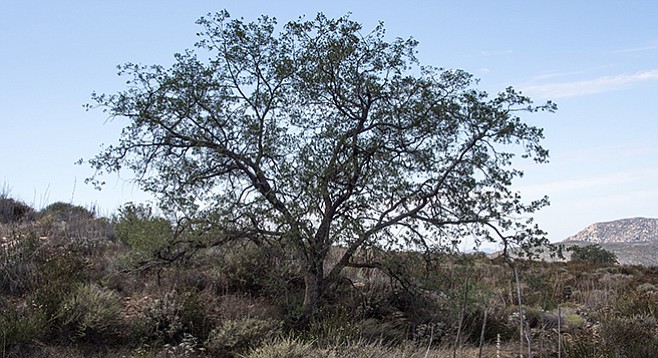
Eagle Peak Preserve is a good place to find Engelmann oaks.
The Eagle Peak Preserve, located about 4.5 miles north of Eagle Peak, is a conservation area managed by the San Diego River Park Foundation (SDRPF) that has breathtaking views of the San Diego River Gorge. It does not include Eagle Peak itself. The upper part of the San Diego River is an important part of the river’s ecosystem. The SDRPF began a program in 2003 to raise funds to purchase this property that was formerly held in private hands within the Cleveland National Forest. The foundation now manages over 700 acres of the Preserve and keeps it open for the public.
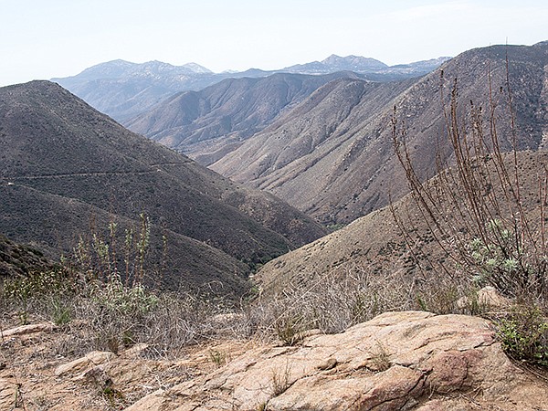
San Diego River canyon view from the preserve
William Marcks, as a recent immigrant from Germany, homesteaded the land that became the Preserve in 1899. He and his family lived there his whole life raising bees and cattle. Since SDRPF acquired most of the former ranch, it has begun to revert back to its natural state. While a few relics of its life as a ranch remain, it now consists of rolling hills covered with coastal sage scrub, lush grasslands, and Engelmann oak woodlands. The views down into the river’s deep gorge and of the surrounding mountains are spectacular.
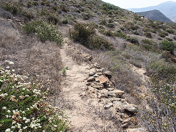
The trail leaves the South Staging area on an old used dirt road in an area that once must have been a homesite. Eucalyptus trees were planted here at some point and are thriving. After passing a water tank that recently has been extensively used for target practice, the road becomes a single-track trail, heading up the side of a hill covered with typical coastal sage scrub. Shortly, it joins another dirt road, labeled the “Historic Trail” on preserve maps. The Historic Trail crosses the Preserve, leaving it at about 2 miles from the South Staging Area. The road may have been part of the mail route between San Diego and Julian in the early part of the 20th century. Certainly it must have required a great deal of hand labor to construct the stone walls that line its downslope side.
Old historic road in Eagle Peak Preserve
The trail goes north up along the west-facing slope of a mountain, reaching the ridge after half a mile of easy upslope hiking. It turns east after crossing the ridge where the vegetation continues to be coastal sage scrub but with a greater variety of species, including scattered Engelmann oaks and blue elderberry. Engelmann oak woodlands typically are savanna-like, with scattered trees set among grasslands or coastal sage. Stately single trees have a main trunk that can rise up to 80 feet. It is relatively sparsely covered with gray-green leaves carried on branches that radiate symmetrically from the trunk. It is also one of the rarest of southern California oaks.
In about a quarter of a mile there will be a branch trail off to your left that goes down to a (now dry) stock pond and some scattered ranching artifacts. If you have the time and energy, you might consider a side trip down to the ramada and picnic table near the pond basin.
The goal of this hike is to reach the top of the unnamed peak at elevation 3200 feet. Although it is just outside the Preserve, peak 3200 offers spectacular, nearly 360-degree views of the Preserve, Eagle Peak, the Cuyamaca Mountains, and the San Diego River Canyon. To reach the peak, continue up the Historic Trail from its junction with the Pond Trail. After it curves north and begins to climb up the west-facing slope of peak 3200, the trail may become difficult to follow. Before the trail crosses a low divide and begins to curve in a southeasterly direction, leave the trail and start your cross-country ascent to the peak. It is open country and relatively easy going. Once you have reached the peak and enjoyed the views, return to your vehicle the way you came.
A few words of caution for this hike: there is little shade except for a ramada that covers a picnic table near a now dry stock pond, and the trails are not signed and frequently overgrown with brush. Take care to always be aware of your location relative to obvious landmarks. The best time to visit is in the spring after the rains have brought this area back to life. After adequate rain you can expect an abundance of wildflowers and flowering shrubs. Perhaps the stock ponds will fill with water and waterfalls may be seen cascading down the Preserve’s many ravines and canyons.
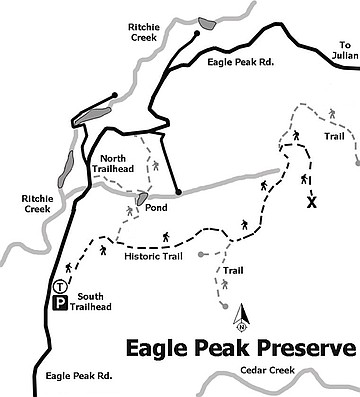
Eagle Peak Preserve trail map
Eagle Peak Preserve
Distance from downtown San Diego: 60 miles. Allow 1 hour driving time. From I-8 go north on CA-79 1.3 miles to Descanso village and turn left on Riverside Drive. Go 0.6 mile and turn left on Viejas Grade Road and proceed 1 block to its intersection with Oak Grove Drive. Go right on Oak Grove Drive and travel 1.6 miles to Boulder Creek Road. Go right on Boulder Creek Road and follow it northwest for 13 miles to a hairpin curve where it intersects with Cedar Creek Road. This is the trailhead for Eagle Peak and Three Sisters Waterfall. Continue 3.5 miles northwest on Cedar Creek Road until it intersects with Eagle Peak Road. Go right and continue for 0.7 mile to the Eagle Peak Preserve South staging area. If gates are open, there is adequate parking. If gates are closed, park on the road without blocking traffic.
Hiking length: 4 miles out-and-back. Allow 3 hours hiking time.
Difficulty: Moderate with up to 1000 feet of elevation gain/loss. Horses, bicycles, and dogs on leashes allowed on the trail. Possible bushwhacking if you lose the trail.
Here's something you might be interested in.
Rare oak dots the hike to Eagle Peak
This hike has breathtaking views of the San Diego River Gorge
Rare oak dots the hike to Eagle Peak
This hike has breathtaking views of the San Diego River Gorge
Eagle Peak Preserve is a good place to find Engelmann oaks.
The Eagle Peak Preserve, located about 4.5 miles north of Eagle Peak, is a conservation area managed by the San Diego River Park Foundation (SDRPF) that has breathtaking views of the San Diego River Gorge. It does not include Eagle Peak itself. The upper part of the San Diego River is an important part of the river’s ecosystem. The SDRPF began a program in 2003 to raise funds to purchase this property that was formerly held in private hands within the Cleveland National Forest. The foundation now manages over 700 acres of the Preserve and keeps it open for the public.
San Diego River canyon view from the preserve
William Marcks, as a recent immigrant from Germany, homesteaded the land that became the Preserve in 1899. He and his family lived there his whole life raising bees and cattle. Since SDRPF acquired most of the former ranch, it has begun to revert back to its natural state. While a few relics of its life as a ranch remain, it now consists of rolling hills covered with coastal sage scrub, lush grasslands, and Engelmann oak woodlands. The views down into the river’s deep gorge and of the surrounding mountains are spectacular.
The trail leaves the South Staging area on an old used dirt road in an area that once must have been a homesite. Eucalyptus trees were planted here at some point and are thriving. After passing a water tank that recently has been extensively used for target practice, the road becomes a single-track trail, heading up the side of a hill covered with typical coastal sage scrub. Shortly, it joins another dirt road, labeled the “Historic Trail” on preserve maps. The Historic Trail crosses the Preserve, leaving it at about 2 miles from the South Staging Area. The road may have been part of the mail route between San Diego and Julian in the early part of the 20th century. Certainly it must have required a great deal of hand labor to construct the stone walls that line its downslope side.
Old historic road in Eagle Peak Preserve
The trail goes north up along the west-facing slope of a mountain, reaching the ridge after half a mile of easy upslope hiking. It turns east after crossing the ridge where the vegetation continues to be coastal sage scrub but with a greater variety of species, including scattered Engelmann oaks and blue elderberry. Engelmann oak woodlands typically are savanna-like, with scattered trees set among grasslands or coastal sage. Stately single trees have a main trunk that can rise up to 80 feet. It is relatively sparsely covered with gray-green leaves carried on branches that radiate symmetrically from the trunk. It is also one of the rarest of southern California oaks.
In about a quarter of a mile there will be a branch trail off to your left that goes down to a (now dry) stock pond and some scattered ranching artifacts. If you have the time and energy, you might consider a side trip down to the ramada and picnic table near the pond basin.
The goal of this hike is to reach the top of the unnamed peak at elevation 3200 feet. Although it is just outside the Preserve, peak 3200 offers spectacular, nearly 360-degree views of the Preserve, Eagle Peak, the Cuyamaca Mountains, and the San Diego River Canyon. To reach the peak, continue up the Historic Trail from its junction with the Pond Trail. After it curves north and begins to climb up the west-facing slope of peak 3200, the trail may become difficult to follow. Before the trail crosses a low divide and begins to curve in a southeasterly direction, leave the trail and start your cross-country ascent to the peak. It is open country and relatively easy going. Once you have reached the peak and enjoyed the views, return to your vehicle the way you came.
A few words of caution for this hike: there is little shade except for a ramada that covers a picnic table near a now dry stock pond, and the trails are not signed and frequently overgrown with brush. Take care to always be aware of your location relative to obvious landmarks. The best time to visit is in the spring after the rains have brought this area back to life. After adequate rain you can expect an abundance of wildflowers and flowering shrubs. Perhaps the stock ponds will fill with water and waterfalls may be seen cascading down the Preserve’s many ravines and canyons.
Eagle Peak Preserve trail map
Eagle Peak Preserve
Distance from downtown San Diego: 60 miles. Allow 1 hour driving time. From I-8 go north on CA-79 1.3 miles to Descanso village and turn left on Riverside Drive. Go 0.6 mile and turn left on Viejas Grade Road and proceed 1 block to its intersection with Oak Grove Drive. Go right on Oak Grove Drive and travel 1.6 miles to Boulder Creek Road. Go right on Boulder Creek Road and follow it northwest for 13 miles to a hairpin curve where it intersects with Cedar Creek Road. This is the trailhead for Eagle Peak and Three Sisters Waterfall. Continue 3.5 miles northwest on Cedar Creek Road until it intersects with Eagle Peak Road. Go right and continue for 0.7 mile to the Eagle Peak Preserve South staging area. If gates are open, there is adequate parking. If gates are closed, park on the road without blocking traffic.
Hiking length: 4 miles out-and-back. Allow 3 hours hiking time.
Difficulty: Moderate with up to 1000 feet of elevation gain/loss. Horses, bicycles, and dogs on leashes allowed on the trail. Possible bushwhacking if you lose the trail.
Comments