Here's something you might be interested in.
Ask a Hipster — Advice you didn't know you needed
Big Screen — Movie commentary
Blurt — Music's inside track
Booze News — San Diego spirits
Classical Music — Immortal beauty
Classifieds — Free and easy
Cover Stories — Front-page features
Drinks All Around — Bartenders' drink recipes
Excerpts — Literary and spiritual excerpts
Feast! — Food & drink reviews
Feature Stories — Local news & stories
Fishing Report — What’s getting hooked from ship and shore
From the Archives — Spotlight on the past
Golden Dreams — Talk of the town
The Gonzo Report — Making the musical scene, or at least reporting from it
Letters — Our inbox
Movies@Home — Local movie buffs share favorites
Movie Reviews — Our critics' picks and pans
Musician Interviews — Up close with local artists
Neighborhood News from Stringers — Hyperlocal news
News Ticker — News & politics
Obermeyer — San Diego politics illustrated
Outdoors — Weekly changes in flora and fauna
Overheard in San Diego — Eavesdropping illustrated
Poetry — The old and the new
Reader Travel — Travel section built by travelers
Reading — The hunt for intellectuals
Roam-O-Rama — SoCal's best hiking/biking trails
San Diego Beer — Inside San Diego suds
SD on the QT — Almost factual news
Sheep and Goats — Places of worship
Special Issues — The best of
Street Style — San Diego streets have style
Surf Diego — Real stories from those braving the waves
Theater — On stage in San Diego this week
Tin Fork — Silver spoon alternative
Under the Radar — Matt Potter's undercover work
Unforgettable — Long-ago San Diego
Unreal Estate — San Diego's priciest pads
Your Week — Daily event picks
Cuyamaca Rancho’s East Mesa Loop — this trail has it all
This rugged, less-visited, and gorgeous side of the park features mountain views, rolling grasslands, dark forests, and deep canyons.
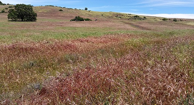
The East Mesa Loop trail passes a grassland meadow en route to Granite Springs.
Most visitors to Cuyamaca Rancho State Park see the reservoir, hike Cuyamaca and Stonewall peaks, and visit Green Valley, but fewer set out for the East Mesa, which is strange because this area contains some of the most spectacular and varied terrain in the park. This trail has it all — views of the mountains in the park and the Lagunas to the east, rolling grasslands, dense pine forests, shaded streams, and a steep descent into a rocky gorge, but it is not a hike for beginners. In the spring it abounds with flowers and is almost overgrown in places due to infrequent use. This hike can be done in one long day or as an overnight at the Granite Spring backcountry campground. There is also the option of two smaller loops for less mileage.
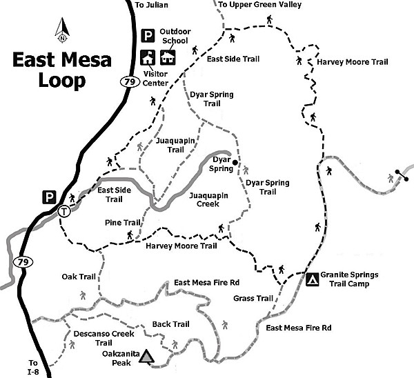
East Mesa trail map
The trailhead is at the parking area. Look for the signed Harvey Moore Trail that starts off to the southeast and ascends steeply up 400 feet to a saddle with a nice view of Oakzanita Peak to the south. A trail branches off left (northeast) after 1.6 miles. (This can be taken 1.3 miles back to the trailhead for a short loop or linked up with the Juaquapin Trail for a longer loop past the park headquarters.) Continue up through oak forest to the lovely rolling grassland of the East Mesa. Don’t forget to look over your shoulder for views of Cuyamaca and Stonewall peaks. Pass the Dyar Spring Trail on the left (north), 1.1 miles after the last junction. (The Dyar Trail links back to the Juaquapin Trail for another potential shorter loop back to the trailhead.) Continue up the grassy slopes to the saddle where you are rewarded with a sweeping view of the Laguna Mountains off to the east.
The trail curves down and north, joining the East Mesa Fire Road and eventually the Granite Spring campground, 1.6 miles past the Dyar junction and 4.3 miles from the trailhead. The Granite Spring site has pit toilets, tent sites, horse corrals, and non-potable water.
From the campground, head north up a hill back onto East Mesa, most of which is in a state wilderness area. The trail follows along an old fence to a grove of pine trees where, about 1 mile after the campground, it takes a sharp bend right (east). At this point, take the Harvey Moore Trail junction left (at an old gate, downed log, and faded sign). Wander through the shaded glen, often bursting with wildflowers. The trail soon takes a steep dive into the Harper Creek drainage along rocky switchbacks. Cross the creek and then parallel it as the trail hugs the northern slope of this steep rocky gorge. After 2.2 miles the trail emerges back into the flat lush Sweetwater River valley. Follow the East Side Trail past the park headquarters 2.2 miles back to the trailhead.
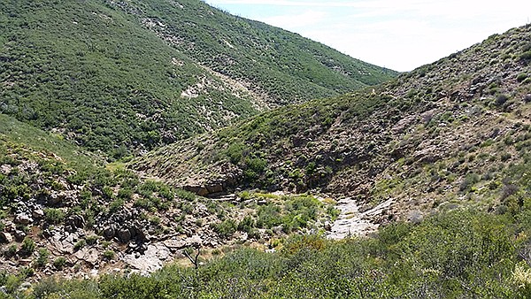
East Mesa canyon on north end of Lake Cuyamaca
As you are hiking, there may be wild turkeys in the area. About 300 of them were introduced into the county by state officials and members of Safari Club International and the Wild Turkey Federation in 1993. Safari Club International paid to have the turkeys hauled to San Diego County from Kansas. With no major predator and abundant food sources, the turkeys have thrived with a population today estimated to be as high as 20,000 ranging from Riverside County to the Mexican border in rural areas. The turkeys are a hybrid mix of a subspecies of Texas Rio Grande and a subspecies of Eastern, common to the Midwest. They roost in trees at night and eat nuts, leaves, and insects. Cuyamaca Rancho State Park is a wild-turkey hotspot. Perhaps they know that they are protected from hunters within the state park.
EAST MESA LOOP — Cuyamaca Rancho State Park
Distance from downtown San Diego: 47 miles. Allow one hour driving time (Cuyamaca Mountains). Take I-8 E and exit at SR-79/Japatul Valley Rd. Drive north on SR-79, 7.7 miles to the large parking area on the right (east), just before the Sweetwater Bridge and one-half mile past the Green Valley Falls Campground.
Hiking length: 9.8-mile loop, with potential overnight at Granite Spring campground.
Difficulty: Strenuous. Elevation gain/loss: 1100 feet. Trails are rocky. Facilities at the trailhead and at Granite Spring campground. Contact Reserve America for reservations at reserveamerica.com or call 800-444-7275. Untreated water at Granite Spring.
Here's something you might be interested in.
Cuyamaca Rancho’s East Mesa Loop — this trail has it all
This rugged, less-visited, and gorgeous side of the park features mountain views, rolling grasslands, dark forests, and deep canyons.
Cuyamaca Rancho’s East Mesa Loop — this trail has it all
This rugged, less-visited, and gorgeous side of the park features mountain views, rolling grasslands, dark forests, and deep canyons.
The East Mesa Loop trail passes a grassland meadow en route to Granite Springs.
Most visitors to Cuyamaca Rancho State Park see the reservoir, hike Cuyamaca and Stonewall peaks, and visit Green Valley, but fewer set out for the East Mesa, which is strange because this area contains some of the most spectacular and varied terrain in the park. This trail has it all — views of the mountains in the park and the Lagunas to the east, rolling grasslands, dense pine forests, shaded streams, and a steep descent into a rocky gorge, but it is not a hike for beginners. In the spring it abounds with flowers and is almost overgrown in places due to infrequent use. This hike can be done in one long day or as an overnight at the Granite Spring backcountry campground. There is also the option of two smaller loops for less mileage.
East Mesa trail map
The trailhead is at the parking area. Look for the signed Harvey Moore Trail that starts off to the southeast and ascends steeply up 400 feet to a saddle with a nice view of Oakzanita Peak to the south. A trail branches off left (northeast) after 1.6 miles. (This can be taken 1.3 miles back to the trailhead for a short loop or linked up with the Juaquapin Trail for a longer loop past the park headquarters.) Continue up through oak forest to the lovely rolling grassland of the East Mesa. Don’t forget to look over your shoulder for views of Cuyamaca and Stonewall peaks. Pass the Dyar Spring Trail on the left (north), 1.1 miles after the last junction. (The Dyar Trail links back to the Juaquapin Trail for another potential shorter loop back to the trailhead.) Continue up the grassy slopes to the saddle where you are rewarded with a sweeping view of the Laguna Mountains off to the east.
The trail curves down and north, joining the East Mesa Fire Road and eventually the Granite Spring campground, 1.6 miles past the Dyar junction and 4.3 miles from the trailhead. The Granite Spring site has pit toilets, tent sites, horse corrals, and non-potable water.
From the campground, head north up a hill back onto East Mesa, most of which is in a state wilderness area. The trail follows along an old fence to a grove of pine trees where, about 1 mile after the campground, it takes a sharp bend right (east). At this point, take the Harvey Moore Trail junction left (at an old gate, downed log, and faded sign). Wander through the shaded glen, often bursting with wildflowers. The trail soon takes a steep dive into the Harper Creek drainage along rocky switchbacks. Cross the creek and then parallel it as the trail hugs the northern slope of this steep rocky gorge. After 2.2 miles the trail emerges back into the flat lush Sweetwater River valley. Follow the East Side Trail past the park headquarters 2.2 miles back to the trailhead.
East Mesa canyon on north end of Lake Cuyamaca
As you are hiking, there may be wild turkeys in the area. About 300 of them were introduced into the county by state officials and members of Safari Club International and the Wild Turkey Federation in 1993. Safari Club International paid to have the turkeys hauled to San Diego County from Kansas. With no major predator and abundant food sources, the turkeys have thrived with a population today estimated to be as high as 20,000 ranging from Riverside County to the Mexican border in rural areas. The turkeys are a hybrid mix of a subspecies of Texas Rio Grande and a subspecies of Eastern, common to the Midwest. They roost in trees at night and eat nuts, leaves, and insects. Cuyamaca Rancho State Park is a wild-turkey hotspot. Perhaps they know that they are protected from hunters within the state park.
EAST MESA LOOP — Cuyamaca Rancho State Park
Distance from downtown San Diego: 47 miles. Allow one hour driving time (Cuyamaca Mountains). Take I-8 E and exit at SR-79/Japatul Valley Rd. Drive north on SR-79, 7.7 miles to the large parking area on the right (east), just before the Sweetwater Bridge and one-half mile past the Green Valley Falls Campground.
Hiking length: 9.8-mile loop, with potential overnight at Granite Spring campground.
Difficulty: Strenuous. Elevation gain/loss: 1100 feet. Trails are rocky. Facilities at the trailhead and at Granite Spring campground. Contact Reserve America for reservations at reserveamerica.com or call 800-444-7275. Untreated water at Granite Spring.
Comments