Here's something you might be interested in.
Ask a Hipster — Advice you didn't know you needed
Big Screen — Movie commentary
Blurt — Music's inside track
Booze News — San Diego spirits
Classical Music — Immortal beauty
Classifieds — Free and easy
Close to Home — What it’s like on the street where you live
Cover Stories — Front-page features
Drinks All Around — Bartenders' drink recipes
Excerpts — Literary and spiritual excerpts
Feast! — Food & drink reviews
Feature Stories — Local news & stories
Fishing Report — What’s getting hooked from ship and shore
From the Archives — Spotlight on the past
Golden Dreams — Talk of the town
The Gonzo Report — Making the musical scene, or at least reporting from it
Letters — Our inbox
Movies@Home — Local movie buffs share favorites
Movie Reviews — Our critics' picks and pans
Musician Interviews — Up close with local artists
Neighborhood News from Stringers — Hyperlocal news
News Ticker — News & politics
Obermeyer — San Diego politics illustrated
Outdoors — Weekly changes in flora and fauna
Overheard in San Diego — Eavesdropping illustrated
Poetry — The old and the new
Reader Travel — Travel section built by travelers
Reading — The hunt for intellectuals
Roam-O-Rama — SoCal's best hiking/biking trails
San Diego Beer — Inside San Diego suds
SD on the QT — Almost factual news
Sheep and Goats — Places of worship
Special Issues — The best of
Street Style — San Diego streets have style
Surf Diego — Real stories from those braving the waves
Theater — On stage in San Diego this week
Tin Fork — Silver spoon alternative
Under the Radar — Matt Potter's undercover work
Unforgettable — Long-ago San Diego
Unreal Estate — San Diego's priciest pads
Your Week — Daily event picks
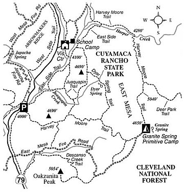
Visit East Mesa in Cuyamaca Rancho State Park, and see how Nature has recovered after the 2003 Cedar Fire.
This past rainy season delivered only a small share of moisture to grassy East Mesa in the Cuyamaca Mountains. So don't wait long if you want to enjoy spring-green rather than summer-yellow meadow vistas. Outlined here is a "grand tour" loop of 10.5 miles, which could take a long morning or a long afternoon to hike. As the map printed here suggests, other, shorter routes into the area are possible. Carry water, and be aware that travel here is by foot or horse only (no mountain bikes).
You start at the Sweetwater River bridge trailhead, on Highway 79, 15.2 miles south of Julian or 7.6 miles north of Interstate 8 at Descanso. From there, follow the Harvey Moore Trail south and east across a hillside dotted with singed oaks and covered with pioneering chaparral vegetation that has sprung up since the Cedar Fire. After about two miles, more burned oaks and pines appear. At the junction of the Dyar Spring Trail (2.4 miles), you'll have gained almost 800 feet, already the majority of the total elevation gain during the entire trip. East Mesa now lies ahead.
East Mesa isn't a mesa in the usual desert sense, but rather a gently inclined bench of broad grasslands interrupted by tree- and brush-covered promontories. The diversity of habitats in this area supports possibly the largest deer herd in the county.
After climbing over a low saddle you come to a junction (3.4 miles). Turn left, and shortly after left again, to reach Granite Spring Primitive Camp (4.0 miles), off to the right side of the trail. A hand pump dispenses potable, but somewhat unpleasant-tasting, iron-rich water. You're better off drinking the water you've brought along.
From Granite Spring, return to the Harvey Moore Trail (which is now coincident with East Mesa Fire Road) and proceed generally north for another one mile to the next junction, where the Deer Park Trail, bound for Cleveland National Forest lands in the Laguna Mountains, heads east. Swing left and follow the continuation of the Harvey Moore Trail north, heading toward the south rim of the deep Harper Creek canyon. You descend gradually at first, then much more sharply on a zigzagging course that has proven difficult to maintain over the years. The postfire recovery of native vegetation -- oaks, pines, manzanita, ceanothus, mountain mahogany, and more -- should be more rapid here than elsewhere, due to the slope's cooler, shadier, north-facing aspect. After an elevation loss of 700 feet, you reach Harper Creek.
The trail turns west and follows Harper Creek downstream; after three crossings, it climbs abruptly up the brushy north slope to a position about 100 feet above the creek to avoid the rocky gorge below. It then contours for about 0.4 mile and then drops sharply to the bank of the creek just below the gorge. Leave the Harvey Moore Trail at this point, cross the creek, and pick up the East Side Trail. Stay on the East Side Trail, enjoying a nearly consistent, slightly downhill stretch of nearly three miles, until you reach the Sweetwater River bridge trailhead.
Here's something you might be interested in.
Visit East Mesa in Cuyamaca Rancho State Park, and see how Nature has recovered after the 2003 Cedar Fire.
Visit East Mesa in Cuyamaca Rancho State Park, and see how Nature has recovered after the 2003 Cedar Fire.
This past rainy season delivered only a small share of moisture to grassy East Mesa in the Cuyamaca Mountains. So don't wait long if you want to enjoy spring-green rather than summer-yellow meadow vistas. Outlined here is a "grand tour" loop of 10.5 miles, which could take a long morning or a long afternoon to hike. As the map printed here suggests, other, shorter routes into the area are possible. Carry water, and be aware that travel here is by foot or horse only (no mountain bikes).
You start at the Sweetwater River bridge trailhead, on Highway 79, 15.2 miles south of Julian or 7.6 miles north of Interstate 8 at Descanso. From there, follow the Harvey Moore Trail south and east across a hillside dotted with singed oaks and covered with pioneering chaparral vegetation that has sprung up since the Cedar Fire. After about two miles, more burned oaks and pines appear. At the junction of the Dyar Spring Trail (2.4 miles), you'll have gained almost 800 feet, already the majority of the total elevation gain during the entire trip. East Mesa now lies ahead.
East Mesa isn't a mesa in the usual desert sense, but rather a gently inclined bench of broad grasslands interrupted by tree- and brush-covered promontories. The diversity of habitats in this area supports possibly the largest deer herd in the county.
After climbing over a low saddle you come to a junction (3.4 miles). Turn left, and shortly after left again, to reach Granite Spring Primitive Camp (4.0 miles), off to the right side of the trail. A hand pump dispenses potable, but somewhat unpleasant-tasting, iron-rich water. You're better off drinking the water you've brought along.
From Granite Spring, return to the Harvey Moore Trail (which is now coincident with East Mesa Fire Road) and proceed generally north for another one mile to the next junction, where the Deer Park Trail, bound for Cleveland National Forest lands in the Laguna Mountains, heads east. Swing left and follow the continuation of the Harvey Moore Trail north, heading toward the south rim of the deep Harper Creek canyon. You descend gradually at first, then much more sharply on a zigzagging course that has proven difficult to maintain over the years. The postfire recovery of native vegetation -- oaks, pines, manzanita, ceanothus, mountain mahogany, and more -- should be more rapid here than elsewhere, due to the slope's cooler, shadier, north-facing aspect. After an elevation loss of 700 feet, you reach Harper Creek.
The trail turns west and follows Harper Creek downstream; after three crossings, it climbs abruptly up the brushy north slope to a position about 100 feet above the creek to avoid the rocky gorge below. It then contours for about 0.4 mile and then drops sharply to the bank of the creek just below the gorge. Leave the Harvey Moore Trail at this point, cross the creek, and pick up the East Side Trail. Stay on the East Side Trail, enjoying a nearly consistent, slightly downhill stretch of nearly three miles, until you reach the Sweetwater River bridge trailhead.