Here's something you might be interested in.
Ask a Hipster — Advice you didn't know you needed
Big Screen — Movie commentary
Blurt — Music's inside track
Booze News — San Diego spirits
Classical Music — Immortal beauty
Classifieds — Free and easy
Cover Stories — Front-page features
Drinks All Around — Bartenders' drink recipes
Excerpts — Literary and spiritual excerpts
Feast! — Food & drink reviews
Feature Stories — Local news & stories
Fishing Report — What’s getting hooked from ship and shore
From the Archives — Spotlight on the past
Golden Dreams — Talk of the town
The Gonzo Report — Making the musical scene, or at least reporting from it
Letters — Our inbox
Movies@Home — Local movie buffs share favorites
Movie Reviews — Our critics' picks and pans
Musician Interviews — Up close with local artists
Neighborhood News from Stringers — Hyperlocal news
News Ticker — News & politics
Obermeyer — San Diego politics illustrated
Outdoors — Weekly changes in flora and fauna
Overheard in San Diego — Eavesdropping illustrated
Poetry — The old and the new
Reader Travel — Travel section built by travelers
Reading — The hunt for intellectuals
Roam-O-Rama — SoCal's best hiking/biking trails
San Diego Beer — Inside San Diego suds
SD on the QT — Almost factual news
Sheep and Goats — Places of worship
Special Issues — The best of
Street Style — San Diego streets have style
Surf Diego — Real stories from those braving the waves
Theater — On stage in San Diego this week
Tin Fork — Silver spoon alternative
Under the Radar — Matt Potter's undercover work
Unforgettable — Long-ago San Diego
Unreal Estate — San Diego's priciest pads
Your Week — Daily event picks
Hacked-out, spectacular view
A view of an unbroken 3000-foot drop to the desert floor.
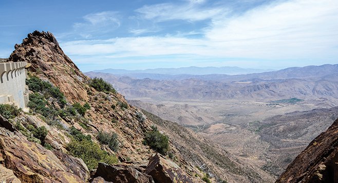
A sense of appreciation grows for the effort that was necessary to chisel a road into this steep slope.
This short segment of the Pacific Crest Trail follows a wide ledge that was hacked out of the near cliff that was once part of the original Sunrise Highway. The ledge drops several thousand feet to the Anza-Borrego Desert below. This segment of the road must have been difficult to maintain and possibly dangerous for motorists. The highway was rerouted to a safer, though less spectacular location, on the other side of a nameless hill in the 1970s. The pavement was largely removed when this became a segment of the Pacific Crest Trail. This trail is one of the most spectacular places to view the transition from mountains to desert. It is also a popular place for trail runners and for hang gliding.
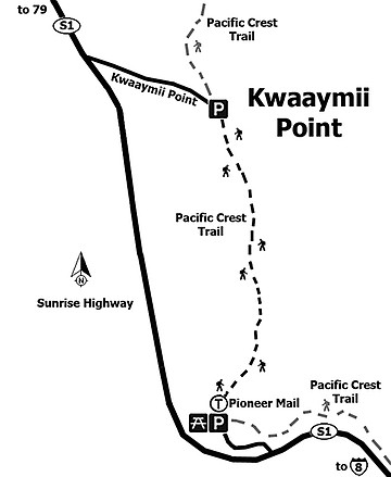
If interested in only visiting Kwaaymii Point and not going on this short hike, then instead of starting at the Pioneer Mail Trailhead, drive to milepost 30.3 on the Sunrise Highway and turn onto Kwaaymii Road on your right. Drive just 0.3 mile down the paved road to its end to arrive at Kwaaymii Point. Parking here doesn’t require an Adventure Pass because it is in the Anza-Borrego Desert State Park rather than in Cleveland National Forest.
From the Pioneer Mail Trailhead, head north on the trail which has all the characteristics of a dirt road as it leads up the slope through low-growing chaparral consisting of shiny-leaf yerba santa, manzanita, buckwheat, chamise, mountain mahogany, and scattered scrub oaks. Continuing up the trail, the drop-off on the right becomes more dramatic and a sense of appreciation begins to grow for the effort that was necessary to chisel a road into this increasingly steep slope. Soon you will be gazing out over a cliff with an unbroken 3000-foot drop down to the floor of Cottonwood Canyon and Mason Valley. The Pinyon Mountains rise up on the other side of the valley and, in the hazy distance, the massive Santa Rosa Mountains loom over the horizon. After a fall or winter storm, the view will be even more spectacular, as you will be able to see much farther.
Kwaaymii Point itself is an aggregate of uplifted, colorful metamorphic rocks, probably Julian schist. These rocks have been used to memorialize a number of fairly recently departed individuals who appear to be known only to their friends and family. The point itself is named for the Kumeyaay band of Indians that lived in the Laguna Mountains and had a reservation there. The Laguna Reservation reverted to private ownership of the Tom Lucas family several years ago. The PCT continues north from Kwaaymii Point an additional 2400 miles. This is a good place to retrace your steps back to the Pioneer Mail Picnic Area.
- Distance from downtown San Diego: About 62 miles. Allow 1 hour and 10 minutes driving time (Laguna Mountains). Take CA-163N, merge onto I-8E, and drive 45 miles to the Sunrise Highway/SR-1 exit. Go north on the Sunrise Highway about 16 miles to the Pioneer Mail Picnic Area and Trailhead at milepost 29.3. Parking is free but a Forest Service Adventure Pass must be displayed on the dashboard of your vehicle at this location.
- Hiking length: 1.4 miles out and back.
- Difficulty: Easy on an obvious trail that was once a part of the Sunrise Highway and is now part of the Pacific Crest Trail (PCT). The picnic area has plenty of free parking, a vault toilet, and picnic tables set among large oaks and pines that escaped the fire that recently burned through this area. Bring your own drinking water; non-potable water is provided for horses. Good for children and dogs on a leash.
Here's something you might be interested in.
Hacked-out, spectacular view
A view of an unbroken 3000-foot drop to the desert floor.
Hacked-out, spectacular view
A view of an unbroken 3000-foot drop to the desert floor.
A sense of appreciation grows for the effort that was necessary to chisel a road into this steep slope.
This short segment of the Pacific Crest Trail follows a wide ledge that was hacked out of the near cliff that was once part of the original Sunrise Highway. The ledge drops several thousand feet to the Anza-Borrego Desert below. This segment of the road must have been difficult to maintain and possibly dangerous for motorists. The highway was rerouted to a safer, though less spectacular location, on the other side of a nameless hill in the 1970s. The pavement was largely removed when this became a segment of the Pacific Crest Trail. This trail is one of the most spectacular places to view the transition from mountains to desert. It is also a popular place for trail runners and for hang gliding.
If interested in only visiting Kwaaymii Point and not going on this short hike, then instead of starting at the Pioneer Mail Trailhead, drive to milepost 30.3 on the Sunrise Highway and turn onto Kwaaymii Road on your right. Drive just 0.3 mile down the paved road to its end to arrive at Kwaaymii Point. Parking here doesn’t require an Adventure Pass because it is in the Anza-Borrego Desert State Park rather than in Cleveland National Forest.
From the Pioneer Mail Trailhead, head north on the trail which has all the characteristics of a dirt road as it leads up the slope through low-growing chaparral consisting of shiny-leaf yerba santa, manzanita, buckwheat, chamise, mountain mahogany, and scattered scrub oaks. Continuing up the trail, the drop-off on the right becomes more dramatic and a sense of appreciation begins to grow for the effort that was necessary to chisel a road into this increasingly steep slope. Soon you will be gazing out over a cliff with an unbroken 3000-foot drop down to the floor of Cottonwood Canyon and Mason Valley. The Pinyon Mountains rise up on the other side of the valley and, in the hazy distance, the massive Santa Rosa Mountains loom over the horizon. After a fall or winter storm, the view will be even more spectacular, as you will be able to see much farther.
Kwaaymii Point itself is an aggregate of uplifted, colorful metamorphic rocks, probably Julian schist. These rocks have been used to memorialize a number of fairly recently departed individuals who appear to be known only to their friends and family. The point itself is named for the Kumeyaay band of Indians that lived in the Laguna Mountains and had a reservation there. The Laguna Reservation reverted to private ownership of the Tom Lucas family several years ago. The PCT continues north from Kwaaymii Point an additional 2400 miles. This is a good place to retrace your steps back to the Pioneer Mail Picnic Area.
- Distance from downtown San Diego: About 62 miles. Allow 1 hour and 10 minutes driving time (Laguna Mountains). Take CA-163N, merge onto I-8E, and drive 45 miles to the Sunrise Highway/SR-1 exit. Go north on the Sunrise Highway about 16 miles to the Pioneer Mail Picnic Area and Trailhead at milepost 29.3. Parking is free but a Forest Service Adventure Pass must be displayed on the dashboard of your vehicle at this location.
- Hiking length: 1.4 miles out and back.
- Difficulty: Easy on an obvious trail that was once a part of the Sunrise Highway and is now part of the Pacific Crest Trail (PCT). The picnic area has plenty of free parking, a vault toilet, and picnic tables set among large oaks and pines that escaped the fire that recently burned through this area. Bring your own drinking water; non-potable water is provided for horses. Good for children and dogs on a leash.