Here's something you might be interested in.
Ask a Hipster — Advice you didn't know you needed
Big Screen — Movie commentary
Blurt — Music's inside track
Booze News — San Diego spirits
Classical Music — Immortal beauty
Classifieds — Free and easy
Cover Stories — Front-page features
Drinks All Around — Bartenders' drink recipes
Excerpts — Literary and spiritual excerpts
Feast! — Food & drink reviews
Feature Stories — Local news & stories
Fishing Report — What’s getting hooked from ship and shore
From the Archives — Spotlight on the past
Golden Dreams — Talk of the town
The Gonzo Report — Making the musical scene, or at least reporting from it
Letters — Our inbox
Movies@Home — Local movie buffs share favorites
Movie Reviews — Our critics' picks and pans
Musician Interviews — Up close with local artists
Neighborhood News from Stringers — Hyperlocal news
News Ticker — News & politics
Obermeyer — San Diego politics illustrated
Outdoors — Weekly changes in flora and fauna
Overheard in San Diego — Eavesdropping illustrated
Poetry — The old and the new
Reader Travel — Travel section built by travelers
Reading — The hunt for intellectuals
Roam-O-Rama — SoCal's best hiking/biking trails
San Diego Beer — Inside San Diego suds
SD on the QT — Almost factual news
Sheep and Goats — Places of worship
Special Issues — The best of
Street Style — San Diego streets have style
Surf Diego — Real stories from those braving the waves
Theater — On stage in San Diego this week
Tin Fork — Silver spoon alternative
Under the Radar — Matt Potter's undercover work
Unforgettable — Long-ago San Diego
Unreal Estate — San Diego's priciest pads
Your Week — Daily event picks
Abundant signs of renewed life
Post-fire Garnet Peak hike boasts a flurry of wildflowers.
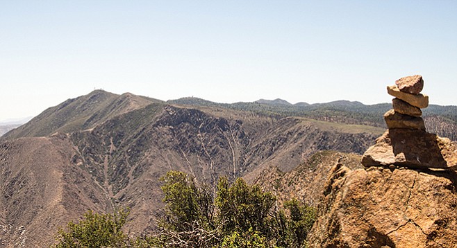
The view toward Mt. Laguna from the peak.
A wildfire swept over Garnet Peak not long ago, but it did not destroy some of the grandest views of any peak in San Diego County. From the top, views extend east to the Salton Sea, south into Mexico, west to the Pacific Ocean, and north to mounts San Jacinto and San Gorgonio.
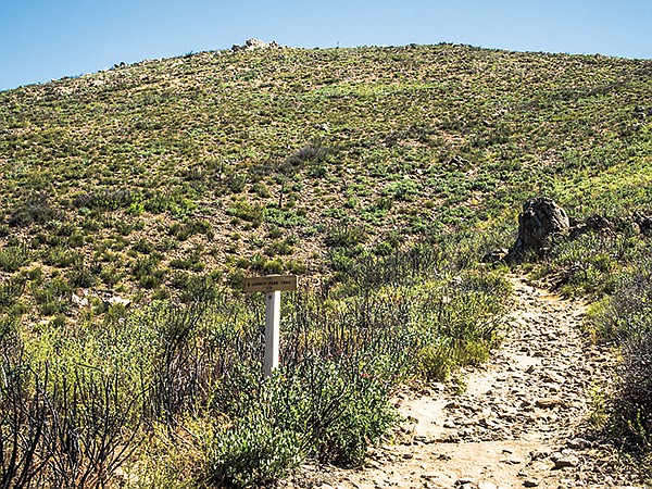
Furthermore, the fire actually promoted the subsequent growth of wildflowers. The Laguna Mountain aster, Orcutt’s linanthus, prickly poppy, and Wallace’s woolly daisy are just some of the unusual or rare plants growing here. The trail proceeds north from the Sunrise Highway, crossing the fire-scarred rolling hills. The scene immediately seems bleak, with charred downed tree trunks and blackened shrub branches everywhere. A closer look reveals abundant signs of renewed life.
Many of the blackened shrub branches show numerous vigorous green shoots sprouting from their base. These stump-sprouters include Eastwood manzanita, mountain mahogany, chamise, and cup leaf ceanothus. Additionally, some chaparral species produce abundant seeds that remain dormant in the soil until after a fire. Chemicals released by fire stimulate these seeds to sprout and begin growth. Frequently, the greatest profusion of wildflowers can be found the first few years after a fire. Even in this drought year, at least 50 different wildflowers either have already bloomed here or are now in bloom. In addition to the rarely found species mentioned above, a July visitor would have found Indian tobacco, goldenrod, bush lupine, white yarrow, monardella, slender sunflower, and prickly poppy, as well as many others.
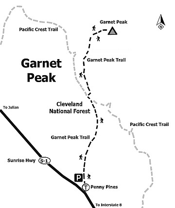
Garnet Peak trail map
Cross the Pacific Crest Trail at 0.65 miles and follow the Garnet Peak Trail as it continues its northern direction up the slope of Garnet Peak. Note the bright red swellings on the leaves of many of the Eastwood manzanita plants lining the trail. A close inspection shows these to be wasp galls, present in an unusual abundance. In another 0.65 miles, you will be on the top of the Peak. Swallowtail butterflies and other insects may be seen hilltopping, thought to be a mate-location behavior, once the temperature warms up during the spring. After contemplating the views in all directions, return the way you came.
Note: Parking at the turnout is limited with alternative starting points to Garnet Peak at Penny Pines or just south of Penny Pines at a turnout. Bring a map of the Pacific Crest Trail in relationship to SR 1 and Garnet Peak. One option is a 5.8-mile walk to the peak from Pioneer Mail Picnic area and back.
- Distance from downtown San Diego: 58 miles. Allow 70 minutes driving time. From I-8 take Sunrise Highway (SR 1) north. Beginning at mile marker 13.5, drive 14.3 miles to mile marker 27.8, 0.5 mile north of Penny Pines to a small turnout and park. An adventure pass is required to park in most areas of the Cleveland National Forest.
- Hiking length: 2.4 miles out and back.
- Difficulty: Moderate with 500 feet elevation loss/gain over a well-marked, easy to follow trail. No facilities or drinking water and little shade on this hike as the recovering trees are still small.
Here's something you might be interested in.
Abundant signs of renewed life
Post-fire Garnet Peak hike boasts a flurry of wildflowers.
Abundant signs of renewed life
Post-fire Garnet Peak hike boasts a flurry of wildflowers.
The view toward Mt. Laguna from the peak.
A wildfire swept over Garnet Peak not long ago, but it did not destroy some of the grandest views of any peak in San Diego County. From the top, views extend east to the Salton Sea, south into Mexico, west to the Pacific Ocean, and north to mounts San Jacinto and San Gorgonio.
Furthermore, the fire actually promoted the subsequent growth of wildflowers. The Laguna Mountain aster, Orcutt’s linanthus, prickly poppy, and Wallace’s woolly daisy are just some of the unusual or rare plants growing here. The trail proceeds north from the Sunrise Highway, crossing the fire-scarred rolling hills. The scene immediately seems bleak, with charred downed tree trunks and blackened shrub branches everywhere. A closer look reveals abundant signs of renewed life.
Many of the blackened shrub branches show numerous vigorous green shoots sprouting from their base. These stump-sprouters include Eastwood manzanita, mountain mahogany, chamise, and cup leaf ceanothus. Additionally, some chaparral species produce abundant seeds that remain dormant in the soil until after a fire. Chemicals released by fire stimulate these seeds to sprout and begin growth. Frequently, the greatest profusion of wildflowers can be found the first few years after a fire. Even in this drought year, at least 50 different wildflowers either have already bloomed here or are now in bloom. In addition to the rarely found species mentioned above, a July visitor would have found Indian tobacco, goldenrod, bush lupine, white yarrow, monardella, slender sunflower, and prickly poppy, as well as many others.
Garnet Peak trail map
Cross the Pacific Crest Trail at 0.65 miles and follow the Garnet Peak Trail as it continues its northern direction up the slope of Garnet Peak. Note the bright red swellings on the leaves of many of the Eastwood manzanita plants lining the trail. A close inspection shows these to be wasp galls, present in an unusual abundance. In another 0.65 miles, you will be on the top of the Peak. Swallowtail butterflies and other insects may be seen hilltopping, thought to be a mate-location behavior, once the temperature warms up during the spring. After contemplating the views in all directions, return the way you came.
Note: Parking at the turnout is limited with alternative starting points to Garnet Peak at Penny Pines or just south of Penny Pines at a turnout. Bring a map of the Pacific Crest Trail in relationship to SR 1 and Garnet Peak. One option is a 5.8-mile walk to the peak from Pioneer Mail Picnic area and back.
- Distance from downtown San Diego: 58 miles. Allow 70 minutes driving time. From I-8 take Sunrise Highway (SR 1) north. Beginning at mile marker 13.5, drive 14.3 miles to mile marker 27.8, 0.5 mile north of Penny Pines to a small turnout and park. An adventure pass is required to park in most areas of the Cleveland National Forest.
- Hiking length: 2.4 miles out and back.
- Difficulty: Moderate with 500 feet elevation loss/gain over a well-marked, easy to follow trail. No facilities or drinking water and little shade on this hike as the recovering trees are still small.