Here's something you might be interested in.
Ask a Hipster — Advice you didn't know you needed
Big Screen — Movie commentary
Blurt — Music's inside track
Booze News — San Diego spirits
Classical Music — Immortal beauty
Classifieds — Free and easy
Cover Stories — Front-page features
Drinks All Around — Bartenders' drink recipes
Excerpts — Literary and spiritual excerpts
Feast! — Food & drink reviews
Feature Stories — Local news & stories
Fishing Report — What’s getting hooked from ship and shore
From the Archives — Spotlight on the past
Golden Dreams — Talk of the town
The Gonzo Report — Making the musical scene, or at least reporting from it
Letters — Our inbox
Movies@Home — Local movie buffs share favorites
Movie Reviews — Our critics' picks and pans
Musician Interviews — Up close with local artists
Neighborhood News from Stringers — Hyperlocal news
News Ticker — News & politics
Obermeyer — San Diego politics illustrated
Outdoors — Weekly changes in flora and fauna
Overheard in San Diego — Eavesdropping illustrated
Poetry — The old and the new
Reader Travel — Travel section built by travelers
Reading — The hunt for intellectuals
Roam-O-Rama — SoCal's best hiking/biking trails
San Diego Beer — Inside San Diego suds
SD on the QT — Almost factual news
Sheep and Goats — Places of worship
Special Issues — The best of
Street Style — San Diego streets have style
Surf Diego — Real stories from those braving the waves
Theater — On stage in San Diego this week
Tin Fork — Silver spoon alternative
Under the Radar — Matt Potter's undercover work
Unforgettable — Long-ago San Diego
Unreal Estate — San Diego's priciest pads
Your Week — Daily event picks
South Fortuna Mountain
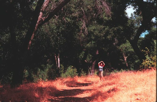
A shady spot in Suycott Wash
Mission Trails Regional Park’s 1291-foot-high South Fortuna Mountain is one of several summits of similar stature stretching from Cowles Mountain in the south to North Fortuna Mountain in the north. It’s easy to understand why this linear range of rounded peaks is called “Long Mountain” on century-old maps.
No route to South Fortuna’s summit is exactly easy. All involve severely steep grades, and the particular route described here features an incline so steep that for one long stretch the trail becomes basically a steep staircase of wood planks, anchored into the mountainside with steel bars. You’ll climb a total of 1400 vertical feet and descend the same.
For this route, park at the San Diego River Crossing Trailhead on Mission Gorge Road, at the foot of Jackson Drive. This is approximately 3.5 miles east of Interstate 8 and 5.5 miles west of Santee’s city center.
From the trailhead follow the wide gravel road north into Mission Gorge, where you cross the San Diego River. The river volume has fluctuated from as little as about one cubic foot per second in a dry summer to a winter record high (in 1916) of about 70,000 cubic feet per second. This time of year, it’s safe to say you won’t have a problem.
A heart-pounding ascent now begins as you abruptly gain more than 300 feet on the steep gravel road. You’re following, more or less, the proposed route for a Jackson Drive extension that was intended to connect with Highway 52 in the north. That will likely never happen.
At the top of the grade, turn right on the first trail intersecting from the right. You plunge downward into a oak-lined ravine bottom called Suycott Wash and meet the paralleling Suycott Wash Trail at 1.0 mile into the hike.
Make a right turn and follow the Suycott Wash Trail down through shade-giving oaks for a while. These oaks have recovered nicely from the ravages of the 2003 Cedar Fire, which thoroughly incinerated most of Mission Trail Regional Park’s acreage north of Mission Gorge Road.
Soon, the trail starts rising on the slope to the left, away from the oaks and onto sunny, south-facing slopes. You keep gaining elevation and curving left, ultimately reaching the south ridge of South Fortuna Mountain. Parts of Mission Gorge come into view on the right, far below. The ridge ahead just gets steeper, and so does the trail, which manages to climb this bouldery section by means of steep steps, rather than by moderate-incline zigzags.
Eventually, the going gets easier and you walk the remaining distance to the high point, 1094-foot South Fortuna Mountain — 2.2 miles from the start.
When it’s time to go, consider your choices. Aside from the easiest way of retracing your steps, you could fashion a number of possible loops to the north, all involving segments of steep trail — perhaps traveling as far as North Fortuna Mountain and the northernmost trails of the park alongside Highway 52.
This article contains information about a publicly owned recreation or wilderness area. Trails and pathways are not necessarily marked. Conditions can change rapidly. Hikers should be properly equipped and have safety and navigational skills. The Reader and Jerry Schad assume no responsibility for any adverse experience.
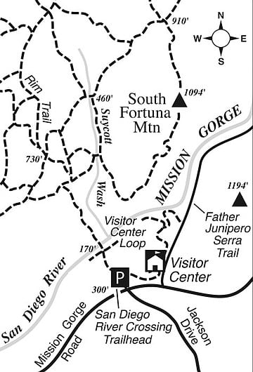
South Fortuna trail map
South Fortuna Mountain
Hike the steepest trail in Mission Trails Regional Park.
Distance from downtown San Diego: 13 miles
Hiking length: 4.4 miles round trip • Difficulty: Moderately strenuous
Here's something you might be interested in.
South Fortuna Mountain
South Fortuna Mountain
A shady spot in Suycott Wash
Mission Trails Regional Park’s 1291-foot-high South Fortuna Mountain is one of several summits of similar stature stretching from Cowles Mountain in the south to North Fortuna Mountain in the north. It’s easy to understand why this linear range of rounded peaks is called “Long Mountain” on century-old maps.
No route to South Fortuna’s summit is exactly easy. All involve severely steep grades, and the particular route described here features an incline so steep that for one long stretch the trail becomes basically a steep staircase of wood planks, anchored into the mountainside with steel bars. You’ll climb a total of 1400 vertical feet and descend the same.
For this route, park at the San Diego River Crossing Trailhead on Mission Gorge Road, at the foot of Jackson Drive. This is approximately 3.5 miles east of Interstate 8 and 5.5 miles west of Santee’s city center.
From the trailhead follow the wide gravel road north into Mission Gorge, where you cross the San Diego River. The river volume has fluctuated from as little as about one cubic foot per second in a dry summer to a winter record high (in 1916) of about 70,000 cubic feet per second. This time of year, it’s safe to say you won’t have a problem.
A heart-pounding ascent now begins as you abruptly gain more than 300 feet on the steep gravel road. You’re following, more or less, the proposed route for a Jackson Drive extension that was intended to connect with Highway 52 in the north. That will likely never happen.
At the top of the grade, turn right on the first trail intersecting from the right. You plunge downward into a oak-lined ravine bottom called Suycott Wash and meet the paralleling Suycott Wash Trail at 1.0 mile into the hike.
Make a right turn and follow the Suycott Wash Trail down through shade-giving oaks for a while. These oaks have recovered nicely from the ravages of the 2003 Cedar Fire, which thoroughly incinerated most of Mission Trail Regional Park’s acreage north of Mission Gorge Road.
Soon, the trail starts rising on the slope to the left, away from the oaks and onto sunny, south-facing slopes. You keep gaining elevation and curving left, ultimately reaching the south ridge of South Fortuna Mountain. Parts of Mission Gorge come into view on the right, far below. The ridge ahead just gets steeper, and so does the trail, which manages to climb this bouldery section by means of steep steps, rather than by moderate-incline zigzags.
Eventually, the going gets easier and you walk the remaining distance to the high point, 1094-foot South Fortuna Mountain — 2.2 miles from the start.
When it’s time to go, consider your choices. Aside from the easiest way of retracing your steps, you could fashion a number of possible loops to the north, all involving segments of steep trail — perhaps traveling as far as North Fortuna Mountain and the northernmost trails of the park alongside Highway 52.
This article contains information about a publicly owned recreation or wilderness area. Trails and pathways are not necessarily marked. Conditions can change rapidly. Hikers should be properly equipped and have safety and navigational skills. The Reader and Jerry Schad assume no responsibility for any adverse experience.
South Fortuna trail map
South Fortuna Mountain
Hike the steepest trail in Mission Trails Regional Park.
Distance from downtown San Diego: 13 miles
Hiking length: 4.4 miles round trip • Difficulty: Moderately strenuous
Comments