Here's something you might be interested in.
Ask a Hipster — Advice you didn't know you needed
Big Screen — Movie commentary
Blurt — Music's inside track
Booze News — San Diego spirits
Classical Music — Immortal beauty
Classifieds — Free and easy
Cover Stories — Front-page features
Drinks All Around — Bartenders' drink recipes
Excerpts — Literary and spiritual excerpts
Feast! — Food & drink reviews
Feature Stories — Local news & stories
Fishing Report — What’s getting hooked from ship and shore
From the Archives — Spotlight on the past
Golden Dreams — Talk of the town
The Gonzo Report — Making the musical scene, or at least reporting from it
Letters — Our inbox
Movies@Home — Local movie buffs share favorites
Movie Reviews — Our critics' picks and pans
Musician Interviews — Up close with local artists
Neighborhood News from Stringers — Hyperlocal news
News Ticker — News & politics
Obermeyer — San Diego politics illustrated
Outdoors — Weekly changes in flora and fauna
Overheard in San Diego — Eavesdropping illustrated
Poetry — The old and the new
Reader Travel — Travel section built by travelers
Reading — The hunt for intellectuals
Roam-O-Rama — SoCal's best hiking/biking trails
San Diego Beer — Inside San Diego suds
SD on the QT — Almost factual news
Sheep and Goats — Places of worship
Special Issues — The best of
Street Style — San Diego streets have style
Surf Diego — Real stories from those braving the waves
Theater — On stage in San Diego this week
Tin Fork — Silver spoon alternative
Under the Radar — Matt Potter's undercover work
Unforgettable — Long-ago San Diego
Unreal Estate — San Diego's priciest pads
Your Week — Daily event picks
Indian Flats Bike Ride
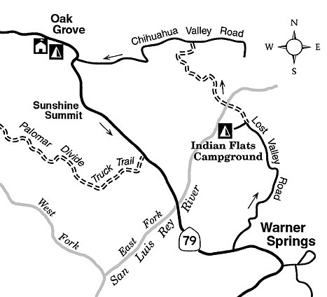
With summer’s heat subsiding throughout San Diego’s backcountry region, now’s the time to think about fat-tire-biking adventures on the back roads of the Cleveland National Forest. One great option is a looping ride of 25 miles that starts near the community of Warner Springs, traverses a bouldery, chaparral-clad landscape to the north on paved and unpaved forest roads, and finally circles back via paved county and state highways.
In addition to the normal biking accoutrements such as water, snacks, sun-shielding clothing, and a helmet, the most important thing to take is water, and more water...yes, the fall season can be bone-dry out there, and potable water is hard (if not impossible) to come by. Note, also, that adversely dry or windy conditions from now through November could trigger a closure of this wildfire-prone section of the national forest. Cleveland National Forest’s Palomar District ranger station, 760-788-0250, will have details.
You can begin the ride at the Lost Valley Road (formerly Indian Flats Road) turnoff along Highway 79, 1.6 miles west of Warner Springs. This starting point is the low point in elevation (2940 feet) along the route.
You begin by pedaling uphill on Lost Valley Road’s narrow, sometimes coiling strip of pavement. The steady ascent takes you through low scrub-brush at first, then through a more interesting mix of ribbonwood and manzanita chaparral. The road swings northeast and then north, and off to the right you get a view of Hot Springs Mountain (highest peak in San Diego County, at 6533 feet), looming in the east, about four miles away.
After four miles of riding you reach an elevation near 4000 feet, where you may spot, but never approach closely, some Coulter pines on the higher slopes above. At 6.3 miles, Lost Valley Road veers left and dives down to Indian Flats Campground, where you can take a break in the shade of oak trees and possibly obtain some drinking water.
Back at the 6.3 mile-mark, a poor dirt road branches north. Follow this road and continue north and northwest, staying right at the next fork 0.3 mile ahead. You then descend slightly to where you must cross the willow- and sycamore-lined San Luis Rey River — a wet or muddy passage following winter rains, but most likely dry this fall season.
After the crossing, you ride uphill along an oak-shaded ravine and then much more steeply up a chaparral-covered hillside to a 4368-foot summit. The view from there extends across miles of virtually untouched open space. Next, a mile of descent northward brings you to the paved, but sparsely traveled Chihuahua Valley Road. Turn left and make a breezy descent to Highway 79. Turn left again, and climb for almost two miles on the highway to the little community of Sunshine Summit (elevation 3913 feet). The route’s concluding segment ahead is a seven-mile, breezy return on Highway 79 to the start — downhill nearly the entire distance.
This article contains information about a publicly owned recreation or wilderness area. Roads and trails are not necessarily marked. Conditions can change rapidly. Mountain bikers should be properly equipped and have safety and navigational skills. The Reader and Jerry Schad assume no responsibility for any adverse experience.
Indian Flats bike ride
Mountain-bike the backcountry roads from Warner Springs to Indian Flats and Chihuahua Valley.
Distance from downtown San Diego: 72 miles
Biking length: 25 miles
Difficulty: Moderately strenuous
Here's something you might be interested in.
Indian Flats Bike Ride
Indian Flats Bike Ride
With summer’s heat subsiding throughout San Diego’s backcountry region, now’s the time to think about fat-tire-biking adventures on the back roads of the Cleveland National Forest. One great option is a looping ride of 25 miles that starts near the community of Warner Springs, traverses a bouldery, chaparral-clad landscape to the north on paved and unpaved forest roads, and finally circles back via paved county and state highways.
In addition to the normal biking accoutrements such as water, snacks, sun-shielding clothing, and a helmet, the most important thing to take is water, and more water...yes, the fall season can be bone-dry out there, and potable water is hard (if not impossible) to come by. Note, also, that adversely dry or windy conditions from now through November could trigger a closure of this wildfire-prone section of the national forest. Cleveland National Forest’s Palomar District ranger station, 760-788-0250, will have details.
You can begin the ride at the Lost Valley Road (formerly Indian Flats Road) turnoff along Highway 79, 1.6 miles west of Warner Springs. This starting point is the low point in elevation (2940 feet) along the route.
You begin by pedaling uphill on Lost Valley Road’s narrow, sometimes coiling strip of pavement. The steady ascent takes you through low scrub-brush at first, then through a more interesting mix of ribbonwood and manzanita chaparral. The road swings northeast and then north, and off to the right you get a view of Hot Springs Mountain (highest peak in San Diego County, at 6533 feet), looming in the east, about four miles away.
After four miles of riding you reach an elevation near 4000 feet, where you may spot, but never approach closely, some Coulter pines on the higher slopes above. At 6.3 miles, Lost Valley Road veers left and dives down to Indian Flats Campground, where you can take a break in the shade of oak trees and possibly obtain some drinking water.
Back at the 6.3 mile-mark, a poor dirt road branches north. Follow this road and continue north and northwest, staying right at the next fork 0.3 mile ahead. You then descend slightly to where you must cross the willow- and sycamore-lined San Luis Rey River — a wet or muddy passage following winter rains, but most likely dry this fall season.
After the crossing, you ride uphill along an oak-shaded ravine and then much more steeply up a chaparral-covered hillside to a 4368-foot summit. The view from there extends across miles of virtually untouched open space. Next, a mile of descent northward brings you to the paved, but sparsely traveled Chihuahua Valley Road. Turn left and make a breezy descent to Highway 79. Turn left again, and climb for almost two miles on the highway to the little community of Sunshine Summit (elevation 3913 feet). The route’s concluding segment ahead is a seven-mile, breezy return on Highway 79 to the start — downhill nearly the entire distance.
This article contains information about a publicly owned recreation or wilderness area. Roads and trails are not necessarily marked. Conditions can change rapidly. Mountain bikers should be properly equipped and have safety and navigational skills. The Reader and Jerry Schad assume no responsibility for any adverse experience.
Indian Flats bike ride
Mountain-bike the backcountry roads from Warner Springs to Indian Flats and Chihuahua Valley.
Distance from downtown San Diego: 72 miles
Biking length: 25 miles
Difficulty: Moderately strenuous