Here's something you might be interested in.
Ask a Hipster — Advice you didn't know you needed
Big Screen — Movie commentary
Blurt — Music's inside track
Booze News — San Diego spirits
Classical Music — Immortal beauty
Classifieds — Free and easy
Cover Stories — Front-page features
Drinks All Around — Bartenders' drink recipes
Excerpts — Literary and spiritual excerpts
Feast! — Food & drink reviews
Feature Stories — Local news & stories
Fishing Report — What’s getting hooked from ship and shore
From the Archives — Spotlight on the past
Golden Dreams — Talk of the town
The Gonzo Report — Making the musical scene, or at least reporting from it
Letters — Our inbox
Movies@Home — Local movie buffs share favorites
Movie Reviews — Our critics' picks and pans
Musician Interviews — Up close with local artists
Neighborhood News from Stringers — Hyperlocal news
News Ticker — News & politics
Obermeyer — San Diego politics illustrated
Outdoors — Weekly changes in flora and fauna
Overheard in San Diego — Eavesdropping illustrated
Poetry — The old and the new
Reader Travel — Travel section built by travelers
Reading — The hunt for intellectuals
Roam-O-Rama — SoCal's best hiking/biking trails
San Diego Beer — Inside San Diego suds
SD on the QT — Almost factual news
Sheep and Goats — Places of worship
Special Issues — The best of
Street Style — San Diego streets have style
Surf Diego — Real stories from those braving the waves
Theater — On stage in San Diego this week
Tin Fork — Silver spoon alternative
Under the Radar — Matt Potter's undercover work
Unforgettable — Long-ago San Diego
Unreal Estate — San Diego's priciest pads
Your Week — Daily event picks
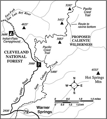
Caliente Wilderness
North of Warner Springs, a several-miles-long segment of the 2650-mile Pacific Crest Trail (PCT) traverses Cleveland National Forest land that may one day be designated the “Caliente Wilderness Area.” Certainly the area is remote enough for official wilderness status. Through here, the PCT winds along boulder-strewn ridges and across small ravines shaded by mini-groves of live oak. There’s little noise other than the wind, and no signs of humankind other than the trail itself.
The six-mile stretch of trail profiled here (12 miles and 1700 feet of elevation gain and loss for the round trip) can be done in one long day or as an overnight backpacking excursion. Now or very soon is a great time to take this trip, since the copious rainfall of the past winter season is producing a bumper crop of fragrant blooms — both chaparral and seasonal wildflowers.
To get to the trailhead from Warner Springs, drive north (toward Aguanga and Temecula) on Highway 79 for about 1.5 miles to the thinly paved Lost Valley Road (aka Indian Flats Road) on the right. Continue up the winding Lost Valley Road for 4.6 miles until you reach a gated, abandoned dirt road on the right, a lateral trail linking to the PCT. Park in the limited space provided, and don’t forget to display your National Forest Adventure Pass on your car. Naturally, you are going to need food and water, and it’s a very good idea to have a map or GPS and basic navigational skills.
Walk up the abandoned road 0.5 mile to the place where the true PCT joins from the right. Continue uphill on the same old roadbed a mile farther to the point where newer and narrower PCT tread diverges right. Make the right turn (by staying left you would descend to a seasonal spring).
The view improves with every step now. You wind up through picturesque granitic outcrops with nice views of Lake Henshaw and the grasslands surrounding it. You lose that view as you pass north of a 5212-foot peak and contour around the head of a ravine.
The PCT continues to climb moderately and winds around another ravine, this just south of a knob also topping out at 5212 feet. It then descends slightly to cross a saddle and resumes climbing on the south side of a hill. From this hill there’s a wonderful vista into Agua Caliente Creek and across to the north slope of Hot Springs Mountain, the 6533-foot summit of which happens to be San Diego County’s high point. From nearly every vantage point but this, Hot Springs Mountain looks like an inconspicuous bump on a ridge, but from here it looks decidedly massive.
Next, the trail bends north and contours, with small ups and downs, along the east side of the ridge containing a 5412-foot peak. These slopes are tinted pink with the blossoms of manzanita and blue and white with blooming ceanothus. A dozen exotic fragrances scent the air. Recent wildfires have singed this area, so only some of the Coulter pines, live oaks, and black oaks scattered about the area are surviving.
At a point east of peak 5412, you’ll see below and to the east a grassy flat, dotted with the remains of Coulter pines and black oaks, along an upper tributary of Agua Caliente Creek. This is a perfect place for a midday picnic, and even better for an overnight stay. Leave the trail at any point where feasible and descend cross-country about 0.2 mile, losing 150 feet, to the seasonal creek. Water trickles through here until about June after a normal wet season. This relatively wet year, the supply should last longer.
You’ve gone six miles, so far, and this is a good place to turn around and retrace your steps on the return.
Caliente Wilderness
Ramble along a remote segment of the Pacific Crest Trail near Warner Springs.
Distance from downtown San Diego: 77 miles
Hiking length: 12 miles round-trip
Difficulty: Moderately strenuous
- This article contains information about a publicly owned recreation or wilderness area. Trails and pathways are not necessarily marked. Conditions can change rapidly. Hikers should be properly equipped and have safety and navigational skills. The Reader and Jerry Schad assume no responsibility for any adverse experience.
Here's something you might be interested in.
Caliente Wilderness
Caliente Wilderness
North of Warner Springs, a several-miles-long segment of the 2650-mile Pacific Crest Trail (PCT) traverses Cleveland National Forest land that may one day be designated the “Caliente Wilderness Area.” Certainly the area is remote enough for official wilderness status. Through here, the PCT winds along boulder-strewn ridges and across small ravines shaded by mini-groves of live oak. There’s little noise other than the wind, and no signs of humankind other than the trail itself.
The six-mile stretch of trail profiled here (12 miles and 1700 feet of elevation gain and loss for the round trip) can be done in one long day or as an overnight backpacking excursion. Now or very soon is a great time to take this trip, since the copious rainfall of the past winter season is producing a bumper crop of fragrant blooms — both chaparral and seasonal wildflowers.
To get to the trailhead from Warner Springs, drive north (toward Aguanga and Temecula) on Highway 79 for about 1.5 miles to the thinly paved Lost Valley Road (aka Indian Flats Road) on the right. Continue up the winding Lost Valley Road for 4.6 miles until you reach a gated, abandoned dirt road on the right, a lateral trail linking to the PCT. Park in the limited space provided, and don’t forget to display your National Forest Adventure Pass on your car. Naturally, you are going to need food and water, and it’s a very good idea to have a map or GPS and basic navigational skills.
Walk up the abandoned road 0.5 mile to the place where the true PCT joins from the right. Continue uphill on the same old roadbed a mile farther to the point where newer and narrower PCT tread diverges right. Make the right turn (by staying left you would descend to a seasonal spring).
The view improves with every step now. You wind up through picturesque granitic outcrops with nice views of Lake Henshaw and the grasslands surrounding it. You lose that view as you pass north of a 5212-foot peak and contour around the head of a ravine.
The PCT continues to climb moderately and winds around another ravine, this just south of a knob also topping out at 5212 feet. It then descends slightly to cross a saddle and resumes climbing on the south side of a hill. From this hill there’s a wonderful vista into Agua Caliente Creek and across to the north slope of Hot Springs Mountain, the 6533-foot summit of which happens to be San Diego County’s high point. From nearly every vantage point but this, Hot Springs Mountain looks like an inconspicuous bump on a ridge, but from here it looks decidedly massive.
Next, the trail bends north and contours, with small ups and downs, along the east side of the ridge containing a 5412-foot peak. These slopes are tinted pink with the blossoms of manzanita and blue and white with blooming ceanothus. A dozen exotic fragrances scent the air. Recent wildfires have singed this area, so only some of the Coulter pines, live oaks, and black oaks scattered about the area are surviving.
At a point east of peak 5412, you’ll see below and to the east a grassy flat, dotted with the remains of Coulter pines and black oaks, along an upper tributary of Agua Caliente Creek. This is a perfect place for a midday picnic, and even better for an overnight stay. Leave the trail at any point where feasible and descend cross-country about 0.2 mile, losing 150 feet, to the seasonal creek. Water trickles through here until about June after a normal wet season. This relatively wet year, the supply should last longer.
You’ve gone six miles, so far, and this is a good place to turn around and retrace your steps on the return.
Caliente Wilderness
Ramble along a remote segment of the Pacific Crest Trail near Warner Springs.
Distance from downtown San Diego: 77 miles
Hiking length: 12 miles round-trip
Difficulty: Moderately strenuous
- This article contains information about a publicly owned recreation or wilderness area. Trails and pathways are not necessarily marked. Conditions can change rapidly. Hikers should be properly equipped and have safety and navigational skills. The Reader and Jerry Schad assume no responsibility for any adverse experience.