Here's something you might be interested in.
Ask a Hipster — Advice you didn't know you needed
Big Screen — Movie commentary
Blurt — Music's inside track
Booze News — San Diego spirits
Classical Music — Immortal beauty
Classifieds — Free and easy
Cover Stories — Front-page features
Drinks All Around — Bartenders' drink recipes
Excerpts — Literary and spiritual excerpts
Feast! — Food & drink reviews
Feature Stories — Local news & stories
Fishing Report — What’s getting hooked from ship and shore
From the Archives — Spotlight on the past
Golden Dreams — Talk of the town
The Gonzo Report — Making the musical scene, or at least reporting from it
Letters — Our inbox
Movies@Home — Local movie buffs share favorites
Movie Reviews — Our critics' picks and pans
Musician Interviews — Up close with local artists
Neighborhood News from Stringers — Hyperlocal news
News Ticker — News & politics
Obermeyer — San Diego politics illustrated
Outdoors — Weekly changes in flora and fauna
Overheard in San Diego — Eavesdropping illustrated
Poetry — The old and the new
Reader Travel — Travel section built by travelers
Reading — The hunt for intellectuals
Roam-O-Rama — SoCal's best hiking/biking trails
San Diego Beer — Inside San Diego suds
SD on the QT — Almost factual news
Sheep and Goats — Places of worship
Special Issues — The best of
Street Style — San Diego streets have style
Surf Diego — Real stories from those braving the waves
Theater — On stage in San Diego this week
Tin Fork — Silver spoon alternative
Under the Radar — Matt Potter's undercover work
Unforgettable — Long-ago San Diego
Unreal Estate — San Diego's priciest pads
Your Week — Daily event picks
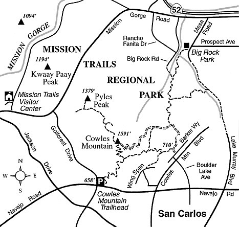
Cowles Mountain to Pyles Peak
Pyles Peak is just one bump in a series of several distinct high points stretching between Cowles Mountain and Fortuna Mountain in East County’s Mission Trails Regional Park. Collectively, the high points make up a small mountain range labeled “Long Mountain” on old maps. The entire range consists of granitic rocks that have been uplifted by geologic forces over many millions of years. Just north of Pyles Peak, there’s a deep notch in the range, where Mission Gorge Road passes through, and farther north is an even deeper notch — Mission Gorge — where the San Diego River has spent millions of years carving its way clear through the steadily rising “Long Mountain.”
A long and tiring out-and-back trek (involving a total elevation gain and loss of 2000 feet!) will get you to the rocky summit of Pyles Peak, where you can enjoy a well-earned view east toward Santee and west toward the ocean. First, though, you have to climb Cowles Mountain — 1591 feet, the highest elevation within the city limits of San Diego.
Drive out to the main Cowles Mountain trailhead, which lies at the northeast corner of Navajo Road and Golfcrest Drive in the San Carlos district of San Diego. The zigzagging trail ahead is popular with hikers and dog-walkers, but no mountain bikes are allowed on it. Climb steadily for 1.4 miles to the top of Cowles, then set your sights on Pyles, which lies more than a mile northward. From the edge of the service road just north of the Cowles summit, find and follow the nicely maintained trail leading north toward Pyles Peak.
Immediately, you leave about 98 percent of the hiker traffic behind and begin a serene descent to a 1230-foot saddle just north of the 1591-foot Cowles summit. From that saddle you climb upward, bending around some switchback corners to gain the ridgeline about midway between the Cowles summit and Pyles Peak. You pass a side-trail leading east to a rather modest view point, good for some privacy perhaps, but little else. The Pyles trail continues north, a little to the west of the ridgeline, and gradually loses elevation. Chaparral-clad slopes fall away on your left to the curving streets and toylike houses of suburbia, which seem to lap at the foot of the mountain. On mornings when a low-elevation marine layer blankets the lowland and the suburban sprawl disappears, the distant, rumbling roar of traffic floats up and reminds you of your place amid the city.
Nearing Pyles Peak, you reach a saddle where the trail bends left and contours west. After another 0.1 mile you come to a junction. The trail straight ahead leads to a nearby dead-end and a fence that discourages further travel in that direction. The trail to the right heads straight up to the Pyles Peak summit, 0.2 mile away. Enjoy the view, then be ready to retrace your steps, which of course will involve a reverse ascent of Cowles Mountain.
This article contains information about a publicly owned recreation or wilderness area. Trails and pathways are not necessarily marked. Conditions can change rapidly. Hikers should be properly equipped and have safety and navigational skills. The Reader and Jerry Schad assume no responsibility for any adverse experience.
Cowles Mountain to Pyles Peak
Traverse the crowning ridgeline of Mission Trails Regional Park.
Distance from downtown San Diego: 14 miles
Hiking/biking length: 5.2 miles round trip
Difficulty: Moderately strenuous
Here's something you might be interested in.
Cowles Mountain to Pyles Peak
Cowles Mountain to Pyles Peak
Pyles Peak is just one bump in a series of several distinct high points stretching between Cowles Mountain and Fortuna Mountain in East County’s Mission Trails Regional Park. Collectively, the high points make up a small mountain range labeled “Long Mountain” on old maps. The entire range consists of granitic rocks that have been uplifted by geologic forces over many millions of years. Just north of Pyles Peak, there’s a deep notch in the range, where Mission Gorge Road passes through, and farther north is an even deeper notch — Mission Gorge — where the San Diego River has spent millions of years carving its way clear through the steadily rising “Long Mountain.”
A long and tiring out-and-back trek (involving a total elevation gain and loss of 2000 feet!) will get you to the rocky summit of Pyles Peak, where you can enjoy a well-earned view east toward Santee and west toward the ocean. First, though, you have to climb Cowles Mountain — 1591 feet, the highest elevation within the city limits of San Diego.
Drive out to the main Cowles Mountain trailhead, which lies at the northeast corner of Navajo Road and Golfcrest Drive in the San Carlos district of San Diego. The zigzagging trail ahead is popular with hikers and dog-walkers, but no mountain bikes are allowed on it. Climb steadily for 1.4 miles to the top of Cowles, then set your sights on Pyles, which lies more than a mile northward. From the edge of the service road just north of the Cowles summit, find and follow the nicely maintained trail leading north toward Pyles Peak.
Immediately, you leave about 98 percent of the hiker traffic behind and begin a serene descent to a 1230-foot saddle just north of the 1591-foot Cowles summit. From that saddle you climb upward, bending around some switchback corners to gain the ridgeline about midway between the Cowles summit and Pyles Peak. You pass a side-trail leading east to a rather modest view point, good for some privacy perhaps, but little else. The Pyles trail continues north, a little to the west of the ridgeline, and gradually loses elevation. Chaparral-clad slopes fall away on your left to the curving streets and toylike houses of suburbia, which seem to lap at the foot of the mountain. On mornings when a low-elevation marine layer blankets the lowland and the suburban sprawl disappears, the distant, rumbling roar of traffic floats up and reminds you of your place amid the city.
Nearing Pyles Peak, you reach a saddle where the trail bends left and contours west. After another 0.1 mile you come to a junction. The trail straight ahead leads to a nearby dead-end and a fence that discourages further travel in that direction. The trail to the right heads straight up to the Pyles Peak summit, 0.2 mile away. Enjoy the view, then be ready to retrace your steps, which of course will involve a reverse ascent of Cowles Mountain.
This article contains information about a publicly owned recreation or wilderness area. Trails and pathways are not necessarily marked. Conditions can change rapidly. Hikers should be properly equipped and have safety and navigational skills. The Reader and Jerry Schad assume no responsibility for any adverse experience.
Cowles Mountain to Pyles Peak
Traverse the crowning ridgeline of Mission Trails Regional Park.
Distance from downtown San Diego: 14 miles
Hiking/biking length: 5.2 miles round trip
Difficulty: Moderately strenuous