Here's something you might be interested in.
Ask a Hipster — Advice you didn't know you needed
Big Screen — Movie commentary
Blurt — Music's inside track
Booze News — San Diego spirits
Classical Music — Immortal beauty
Classifieds — Free and easy
Close to Home — What it’s like on the street where you live
Cover Stories — Front-page features
Drinks All Around — Bartenders' drink recipes
Excerpts — Literary and spiritual excerpts
Feast! — Food & drink reviews
Feature Stories — Local news & stories
Fishing Report — What’s getting hooked from ship and shore
From the Archives — Spotlight on the past
Golden Dreams — Talk of the town
The Gonzo Report — Making the musical scene, or at least reporting from it
Letters — Our inbox
Movies@Home — Local movie buffs share favorites
Movie Reviews — Our critics' picks and pans
Musician Interviews — Up close with local artists
Neighborhood News from Stringers — Hyperlocal news
News Ticker — News & politics
Obermeyer — San Diego politics illustrated
Outdoors — Weekly changes in flora and fauna
Overheard in San Diego — Eavesdropping illustrated
Poetry — The old and the new
Reader Travel — Travel section built by travelers
Reading — The hunt for intellectuals
Roam-O-Rama — SoCal's best hiking/biking trails
San Diego Beer — Inside San Diego suds
SD on the QT — Almost factual news
Sheep and Goats — Places of worship
Special Issues — The best of
Street Style — San Diego streets have style
Surf Diego — Real stories from those braving the waves
Theater — On stage in San Diego this week
Tin Fork — Silver spoon alternative
Under the Radar — Matt Potter's undercover work
Unforgettable — Long-ago San Diego
Unreal Estate — San Diego's priciest pads
Your Week — Daily event picks
Cowles Mountain - East
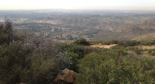
Looking down Mission Gorge from Cowles Mountain toward the ocean
Take the trail less traveled to the Cowles Mountain summit
Directions from downtown San Diego: 15 miles. Allow 30 minutes’ driving time. (San Carlos, Mission Trails Regional Park) From I-8, exit north on College Ave. and then turn right (east) on Navajo Rd. Turn left (north) on Cowles Mountain Blvd. and follow it 0.4 miles to Boulder Lake Ave. Turn left, go one block to Barker Way, and turn right. Park on the street. No facilities.
Hiking length: 3.0 miles round trip.
Difficulty: Intermediate; 1000-ft. elevation change.
As both the highest peak in San Diego and one of the most popular hiking destinations in the county, Cowles Mountain is better known for spectacular views of Southern California than quiet, wilderness solitude. Indeed, the popular southern route that begins near the corner of Navajo Road and Golfcrest Drive accommodates at least several hundred hikers daily. But start your hike just a little more than a mile to the east, and you can have the same superb hiking and sweeping vistas that make Cowles so popular with a fraction of the south-route crowds, not to mention an easier time finding a parking spot.
This eastern route begins off of Barker Way, near its intersection with Boulder Lake Avenue. Park on the street and enter through the gate on the northwest side of the road to find a small kiosk with park and safety information. Continue up the gravel road 150 yards and turn left at a sign indicating the Barker Way Trail and Cowles Mountain summit. Stay to your right as you begin your ascent to avoid a southern offshoot that returns to San Carlos neighborhoods. A string of consecutive switchbacks and an escalating heart rate are good clues that you are going the right way.
Continue climbing for about a mile until the trail intersects with the popular southern route, and then turn right to finish the trek to the summit. Although the relative solitude of the east trail is lost at this point, there are good reasons for Cowles’ popularity. The 360° views are well worth another grueling half-mile of switchbacks even on a crowded weekend day. The 1591-foot summit offers panoramic views reaching to northern Baja with interpretive signs to help hikers identify natural and manmade landmarks throughout the region.
Return to Barker Way via the same trail or make a loop by turning right (east) on the service road that passes just north of the peak. Either option provides a 3-mile round-trip hike with nearly 1000-feet in elevation gain. Shade is scarce on the exposed southern slope, so this is a great hike for winter or spring when temperatures are milder. Wildflowers may also be abundant at this time of year. Consider early morning or evening hikes in the summer and always bring plenty of water.
Canyoneers are San Diego Natural History Museum volunteers trained to lead interpretive nature walks that teach appreciation for the great outdoors. For a schedule of free public hikes:
http://www.sdnhm.org/education/naturalists-of-all-ages/canyoneer-hikes/
Here's something you might be interested in.
Cowles Mountain - East
Cowles Mountain - East
Looking down Mission Gorge from Cowles Mountain toward the ocean
Take the trail less traveled to the Cowles Mountain summit
Directions from downtown San Diego: 15 miles. Allow 30 minutes’ driving time. (San Carlos, Mission Trails Regional Park) From I-8, exit north on College Ave. and then turn right (east) on Navajo Rd. Turn left (north) on Cowles Mountain Blvd. and follow it 0.4 miles to Boulder Lake Ave. Turn left, go one block to Barker Way, and turn right. Park on the street. No facilities.
Hiking length: 3.0 miles round trip.
Difficulty: Intermediate; 1000-ft. elevation change.
As both the highest peak in San Diego and one of the most popular hiking destinations in the county, Cowles Mountain is better known for spectacular views of Southern California than quiet, wilderness solitude. Indeed, the popular southern route that begins near the corner of Navajo Road and Golfcrest Drive accommodates at least several hundred hikers daily. But start your hike just a little more than a mile to the east, and you can have the same superb hiking and sweeping vistas that make Cowles so popular with a fraction of the south-route crowds, not to mention an easier time finding a parking spot.
This eastern route begins off of Barker Way, near its intersection with Boulder Lake Avenue. Park on the street and enter through the gate on the northwest side of the road to find a small kiosk with park and safety information. Continue up the gravel road 150 yards and turn left at a sign indicating the Barker Way Trail and Cowles Mountain summit. Stay to your right as you begin your ascent to avoid a southern offshoot that returns to San Carlos neighborhoods. A string of consecutive switchbacks and an escalating heart rate are good clues that you are going the right way.
Continue climbing for about a mile until the trail intersects with the popular southern route, and then turn right to finish the trek to the summit. Although the relative solitude of the east trail is lost at this point, there are good reasons for Cowles’ popularity. The 360° views are well worth another grueling half-mile of switchbacks even on a crowded weekend day. The 1591-foot summit offers panoramic views reaching to northern Baja with interpretive signs to help hikers identify natural and manmade landmarks throughout the region.
Return to Barker Way via the same trail or make a loop by turning right (east) on the service road that passes just north of the peak. Either option provides a 3-mile round-trip hike with nearly 1000-feet in elevation gain. Shade is scarce on the exposed southern slope, so this is a great hike for winter or spring when temperatures are milder. Wildflowers may also be abundant at this time of year. Consider early morning or evening hikes in the summer and always bring plenty of water.
Canyoneers are San Diego Natural History Museum volunteers trained to lead interpretive nature walks that teach appreciation for the great outdoors. For a schedule of free public hikes:
http://www.sdnhm.org/education/naturalists-of-all-ages/canyoneer-hikes/
Comments