Here's something you might be interested in.
Ask a Hipster — Advice you didn't know you needed
Big Screen — Movie commentary
Blurt — Music's inside track
Booze News — San Diego spirits
Classical Music — Immortal beauty
Classifieds — Free and easy
Close to Home — What it’s like on the street where you live
Cover Stories — Front-page features
Drinks All Around — Bartenders' drink recipes
Excerpts — Literary and spiritual excerpts
Feast! — Food & drink reviews
Feature Stories — Local news & stories
Fishing Report — What’s getting hooked from ship and shore
From the Archives — Spotlight on the past
Golden Dreams — Talk of the town
The Gonzo Report — Making the musical scene, or at least reporting from it
Letters — Our inbox
Movies@Home — Local movie buffs share favorites
Movie Reviews — Our critics' picks and pans
Musician Interviews — Up close with local artists
Neighborhood News from Stringers — Hyperlocal news
News Ticker — News & politics
Obermeyer — San Diego politics illustrated
Outdoors — Weekly changes in flora and fauna
Overheard in San Diego — Eavesdropping illustrated
Poetry — The old and the new
Reader Travel — Travel section built by travelers
Reading — The hunt for intellectuals
Roam-O-Rama — SoCal's best hiking/biking trails
San Diego Beer — Inside San Diego suds
SD on the QT — Almost factual news
Sheep and Goats — Places of worship
Special Issues — The best of
Street Style — San Diego streets have style
Surf Diego — Real stories from those braving the waves
Theater — On stage in San Diego this week
Tin Fork — Silver spoon alternative
Under the Radar — Matt Potter's undercover work
Unforgettable — Long-ago San Diego
Unreal Estate — San Diego's priciest pads
Your Week — Daily event picks
Mount Lee
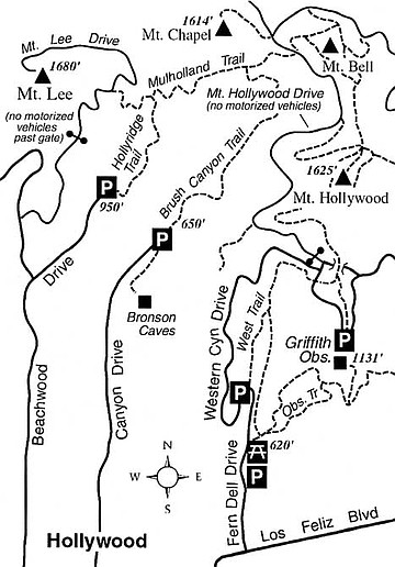
At 1680 feet above sea level, the summit of Mount Lee perches high above the Los Angeles Basin on the western edge of spacious Griffith Park. In addition to hosting the iconic “Hollywood” sign, the summit area offers one of the most stupendous views of the Southland’s real estate — carpets of houses, shopping centers, industrial buildings, and office towers that roll out miles and miles toward distant snow-capped peaks and the blue Pacific Ocean.
Mount Lee’s summit, although largely occupied by a fenced-off antenna installation, can be reached from below by self-propelled means — typically, walking and mountain biking. A great place to begin is the Hollyridge Trail, which starts just shy of the Sunset Ranch Stables at the north end of Beachwood Drive in the Hollywood Hills. Beachwood Drive runs north from Franklin Avenue, which itself is accessible from the Hollywood (101) Freeway in Hollywood, or from Interstate 5 via Los Feliz Boulevard.
A small dirt parking area just below the stables has room for only a few cars. There’s more space for parking one-quarter mile below, along Beachwood Drive or residential streets parallel to it.
From the dirt lot, climb briefly south to a hillside vantage point where you can gaze south over the Hollywood Hills and the L.A. Basin to the Palos Verdes Peninsula, Long Beach, and (when clear enough) Santa Catalina Island. From there, swing left and continue uphill (north) on the Hollyridge Trail. Horses and riders from the nearby stables are sometimes in view ahead; behind you is an ever-widening view of the L.A. Basin. Eventually, the tops of Los Angeles’ downtown office towers come into view.
At about 0.5 mile you reach a junction. Go left on Mulholland Trail, and follow its curvy course west until you reach the paved (but closed to motorized traffic) service road called Mount Lee Drive. Follow that road uphill to a crest where a full, 180-degree sweep of the San Fernando Valley comes into view. Keep climbing, and don’t give up until you reach the summit.
A formidable fence divides the topmost part of Mount Lee from the sheer slope below, which precariously supports the spindly looking whitewashed letters of the famous sign. Climb a rocky peaklet at the end of the service road (just shy of the antenna installation) to get a nearly 360-degree view of the landscape. Through the month of March, and perhaps into April, you’ll probably notice a prominent mantle of snow on a rounded peak far to the east. That’s Mount San Antonio, or Old Baldy, 10,064 feet above sea level — the highest point in Los Angeles County.
Mount Lee
In L.A.’s Griffith Park, climb to a perch overlooking the “Hollywood” sign and a whole lot more.
Distance from downtown San Diego: 128 miles
Length: 3.0 miles round trip
Difficulty: Moderate
Here's something you might be interested in.
Mount Lee
Mount Lee
At 1680 feet above sea level, the summit of Mount Lee perches high above the Los Angeles Basin on the western edge of spacious Griffith Park. In addition to hosting the iconic “Hollywood” sign, the summit area offers one of the most stupendous views of the Southland’s real estate — carpets of houses, shopping centers, industrial buildings, and office towers that roll out miles and miles toward distant snow-capped peaks and the blue Pacific Ocean.
Mount Lee’s summit, although largely occupied by a fenced-off antenna installation, can be reached from below by self-propelled means — typically, walking and mountain biking. A great place to begin is the Hollyridge Trail, which starts just shy of the Sunset Ranch Stables at the north end of Beachwood Drive in the Hollywood Hills. Beachwood Drive runs north from Franklin Avenue, which itself is accessible from the Hollywood (101) Freeway in Hollywood, or from Interstate 5 via Los Feliz Boulevard.
A small dirt parking area just below the stables has room for only a few cars. There’s more space for parking one-quarter mile below, along Beachwood Drive or residential streets parallel to it.
From the dirt lot, climb briefly south to a hillside vantage point where you can gaze south over the Hollywood Hills and the L.A. Basin to the Palos Verdes Peninsula, Long Beach, and (when clear enough) Santa Catalina Island. From there, swing left and continue uphill (north) on the Hollyridge Trail. Horses and riders from the nearby stables are sometimes in view ahead; behind you is an ever-widening view of the L.A. Basin. Eventually, the tops of Los Angeles’ downtown office towers come into view.
At about 0.5 mile you reach a junction. Go left on Mulholland Trail, and follow its curvy course west until you reach the paved (but closed to motorized traffic) service road called Mount Lee Drive. Follow that road uphill to a crest where a full, 180-degree sweep of the San Fernando Valley comes into view. Keep climbing, and don’t give up until you reach the summit.
A formidable fence divides the topmost part of Mount Lee from the sheer slope below, which precariously supports the spindly looking whitewashed letters of the famous sign. Climb a rocky peaklet at the end of the service road (just shy of the antenna installation) to get a nearly 360-degree view of the landscape. Through the month of March, and perhaps into April, you’ll probably notice a prominent mantle of snow on a rounded peak far to the east. That’s Mount San Antonio, or Old Baldy, 10,064 feet above sea level — the highest point in Los Angeles County.
Mount Lee
In L.A.’s Griffith Park, climb to a perch overlooking the “Hollywood” sign and a whole lot more.
Distance from downtown San Diego: 128 miles
Length: 3.0 miles round trip
Difficulty: Moderate