Here's something you might be interested in.
Ask a Hipster — Advice you didn't know you needed
Big Screen — Movie commentary
Blurt — Music's inside track
Booze News — San Diego spirits
Classical Music — Immortal beauty
Classifieds — Free and easy
Cover Stories — Front-page features
Drinks All Around — Bartenders' drink recipes
Excerpts — Literary and spiritual excerpts
Feast! — Food & drink reviews
Feature Stories — Local news & stories
Fishing Report — What’s getting hooked from ship and shore
From the Archives — Spotlight on the past
Golden Dreams — Talk of the town
The Gonzo Report — Making the musical scene, or at least reporting from it
Letters — Our inbox
Movies@Home — Local movie buffs share favorites
Movie Reviews — Our critics' picks and pans
Musician Interviews — Up close with local artists
Neighborhood News from Stringers — Hyperlocal news
News Ticker — News & politics
Obermeyer — San Diego politics illustrated
Outdoors — Weekly changes in flora and fauna
Overheard in San Diego — Eavesdropping illustrated
Poetry — The old and the new
Reader Travel — Travel section built by travelers
Reading — The hunt for intellectuals
Roam-O-Rama — SoCal's best hiking/biking trails
San Diego Beer — Inside San Diego suds
SD on the QT — Almost factual news
Sheep and Goats — Places of worship
Special Issues — The best of
Street Style — San Diego streets have style
Surf Diego — Real stories from those braving the waves
Theater — On stage in San Diego this week
Tin Fork — Silver spoon alternative
Under the Radar — Matt Potter's undercover work
Unforgettable — Long-ago San Diego
Unreal Estate — San Diego's priciest pads
Your Week — Daily event picks
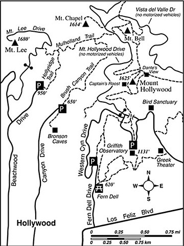
Mulholland Ridge
Los Angeles’s scenic and storied Mulholland Drive/Highway skims across the crest of the Santa Monica Mountains from the Hollywood Hills all the way to Ventura County. If Mulholland were ever extended farther eastward from its eastern end, it would probably snake along the sharply defined ridge between Mount Lee and Mount Chapel in Griffith Park. But for now, and probably forever, the phenomenal views both north and south from this ridge remain the privilege of self-propelled travelers only. For the purpose of this hike description, these self-propelled travelers include only those on foot (or paw, in the case of dogs). Mountain biking is not allowed on the dirt roads and trails of Griffith Park.
To get to the starting point, drive into Hollywood using the Hollywood Freeway (U.S. 101). From Franklin Avenue, a half mile east of the Hollywood Freeway, turn north on Canyon Drive. Follow Canyon Drive all the way to its far end. There’s room for parking in a small lot here or back a little way alongside Canyon Drive itself.
Nearby — just east and possibly worth a side trip at some point — lie Bronson Caves, which are the remnants of quarrying operations during the early 20th Century. The excavations were later used as an outdoor set for plenty of Hollywood film and television productions, including the 1960s television series Batman.
Our hike, however, starts at the end of Canyon Drive and proceeds past a gate onto the dirt-road extension of Canyon Drive, which climbs steadily up the east slope of a ravine known as Brush Canyon (or, alternately, Bronson Canyon). After 1.1 miles (and 600 feet of elevation gain) you come to an intersection of a fire road known as the Mulholland Trail (Mulholland Highway on some older maps). Turn right and continue climbing a little until you reach the paved-but-closed-to-auto-traffic Mount Hollywood Drive. Make a sharp left there, walk on pavement for another 0.2 mile, and then cut left on the wide path going up along the southeast slope of Mount Chapel. The path leads to a water tank just north of the peak itself, and you can improvise a route to the 1614-foot summit. You’ve gained about 1000 feet of elevation to get here, and a great view is one reward for that effort.
On Mount Chapel you almost feel like you’re flying as you gaze a thousand feet down on the Hollywood foothills to the south and the tidy green spaces of Forest Lawn Memorial Park to the north. When you’re satisfied with the complete view, return to Mount Hollywood Drive and head back the same way you came.
This article contains information about a publicly owned recreation or wilderness area. Trails and pathways are not necessarily marked. Conditions can change rapidly. Hikers should be properly equipped and have safety and navigational skills. The Reader and Jerry Schad assume no responsibility for any adverse experience.
MULHOLLAND RIDGE
Get a comprehensive view of the L.A. metropolis from Griffith Park’s highest ridge.
Distance from downtown San Diego: 125 miles
Hiking length: 3.6 miles round-trip
Difficulty: Moderate
Here's something you might be interested in.
Mulholland Ridge
Mulholland Ridge
Los Angeles’s scenic and storied Mulholland Drive/Highway skims across the crest of the Santa Monica Mountains from the Hollywood Hills all the way to Ventura County. If Mulholland were ever extended farther eastward from its eastern end, it would probably snake along the sharply defined ridge between Mount Lee and Mount Chapel in Griffith Park. But for now, and probably forever, the phenomenal views both north and south from this ridge remain the privilege of self-propelled travelers only. For the purpose of this hike description, these self-propelled travelers include only those on foot (or paw, in the case of dogs). Mountain biking is not allowed on the dirt roads and trails of Griffith Park.
To get to the starting point, drive into Hollywood using the Hollywood Freeway (U.S. 101). From Franklin Avenue, a half mile east of the Hollywood Freeway, turn north on Canyon Drive. Follow Canyon Drive all the way to its far end. There’s room for parking in a small lot here or back a little way alongside Canyon Drive itself.
Nearby — just east and possibly worth a side trip at some point — lie Bronson Caves, which are the remnants of quarrying operations during the early 20th Century. The excavations were later used as an outdoor set for plenty of Hollywood film and television productions, including the 1960s television series Batman.
Our hike, however, starts at the end of Canyon Drive and proceeds past a gate onto the dirt-road extension of Canyon Drive, which climbs steadily up the east slope of a ravine known as Brush Canyon (or, alternately, Bronson Canyon). After 1.1 miles (and 600 feet of elevation gain) you come to an intersection of a fire road known as the Mulholland Trail (Mulholland Highway on some older maps). Turn right and continue climbing a little until you reach the paved-but-closed-to-auto-traffic Mount Hollywood Drive. Make a sharp left there, walk on pavement for another 0.2 mile, and then cut left on the wide path going up along the southeast slope of Mount Chapel. The path leads to a water tank just north of the peak itself, and you can improvise a route to the 1614-foot summit. You’ve gained about 1000 feet of elevation to get here, and a great view is one reward for that effort.
On Mount Chapel you almost feel like you’re flying as you gaze a thousand feet down on the Hollywood foothills to the south and the tidy green spaces of Forest Lawn Memorial Park to the north. When you’re satisfied with the complete view, return to Mount Hollywood Drive and head back the same way you came.
This article contains information about a publicly owned recreation or wilderness area. Trails and pathways are not necessarily marked. Conditions can change rapidly. Hikers should be properly equipped and have safety and navigational skills. The Reader and Jerry Schad assume no responsibility for any adverse experience.
MULHOLLAND RIDGE
Get a comprehensive view of the L.A. metropolis from Griffith Park’s highest ridge.
Distance from downtown San Diego: 125 miles
Hiking length: 3.6 miles round-trip
Difficulty: Moderate