Here's something you might be interested in.
Ask a Hipster — Advice you didn't know you needed
Big Screen — Movie commentary
Blurt — Music's inside track
Booze News — San Diego spirits
Classical Music — Immortal beauty
Classifieds — Free and easy
Close to Home — What it’s like on the street where you live
Cover Stories — Front-page features
Drinks All Around — Bartenders' drink recipes
Excerpts — Literary and spiritual excerpts
Feast! — Food & drink reviews
Feature Stories — Local news & stories
Fishing Report — What’s getting hooked from ship and shore
From the Archives — Spotlight on the past
Golden Dreams — Talk of the town
The Gonzo Report — Making the musical scene, or at least reporting from it
Letters — Our inbox
Movies@Home — Local movie buffs share favorites
Movie Reviews — Our critics' picks and pans
Musician Interviews — Up close with local artists
Neighborhood News from Stringers — Hyperlocal news
News Ticker — News & politics
Obermeyer — San Diego politics illustrated
Outdoors — Weekly changes in flora and fauna
Overheard in San Diego — Eavesdropping illustrated
Poetry — The old and the new
Reader Travel — Travel section built by travelers
Reading — The hunt for intellectuals
Roam-O-Rama — SoCal's best hiking/biking trails
San Diego Beer — Inside San Diego suds
SD on the QT — Almost factual news
Sheep and Goats — Places of worship
Special Issues — The best of
Street Style — San Diego streets have style
Surf Diego — Real stories from those braving the waves
Theater — On stage in San Diego this week
Tin Fork — Silver spoon alternative
Under the Radar — Matt Potter's undercover work
Unforgettable — Long-ago San Diego
Unreal Estate — San Diego's priciest pads
Your Week — Daily event picks
San Felipe Hills
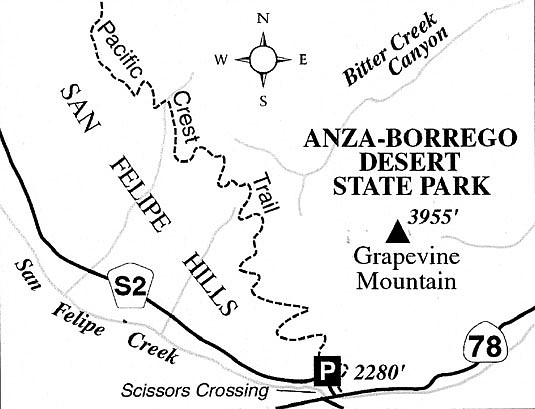
The 2600-mile Pacific Crest Trail (PCT), which was intended to hit as many high points as possible along its mountainous route between the Mexican and Canadian borders, takes an anomalous detour into the Anza-Borrego Desert within San Diego County. At the time this segment of the PCT was built (1980s), a shorter, high-elevation route following the forested Volcan Mountain crest to the west was unavailable due to a large parcel of private property in the way. As a result, the PCT was circuitously routed down from the Laguna Mountain crest to Scissors Crossing, then up and over the dry San Felipe Hills toward Warner Springs. The excessively winding, 24-mile stretch between Scissors Crossing and Highway S-22, featuring no water, furnace-like heat at times, and only marginal camping spots, challenges the patience of anyone who tries to follow it all the way — including the Mexico-to-Canada “through-hikers,” who typically travel this section in April.
For those with an interest in botany, however, the San Felipe stretch of the PCT — at least the initial couple of miles upward from Scissors Crossing — is rewarding, especially after winter rains bring sufficient moisture to the desert.
From Scissors Crossing (the intersection of Highways 78 and S-2, which is 12 miles east of Julian), drive 0.2 mile north on S-2 from Highway 78 to a large parking lot on the right, which is a staging area for the PCT. From the northeast corner of that parking lot, hike north up a wide, sandy wash for 0.1 mile. On the left you’ll find the PCT trail tread cut into the hillside. Climb up to it, go left and steadily ascend for the next two miles on a winding course through an excellent cross-section of mid-level desert vegetation, mainly of the succulent and prickly variety.
Look for and try to identify the following common desert plants: teddy-bear cholla, buckhorn cholla, hedgehog cactus, prickly-pear cactus, barrel cactus, ocotillo, mojave yucca, desert apricot, jojoba, juniper, and agave. The cactus plants plump up with abundant rainfall and shrink during periods of drought. After periods of rainfall, the normally dry and stony slopes wear a fresh coat of tender grass, highlighted by annual and perennial wildflowers of a dozen hues.
As you climb upward, the sound of traffic on the highways below mutes, and the cinemascopic view takes in the long sweep of the aligned San Felipe and Earthquake valleys below, and the parallel Volcan Mountain crest. The generally linear alignments of landforms are due to the parallel Elsinore and Earthquake Valley faults, which underlie the area.
After about two miles of upward travel, the trail crosses a small wash and begins to level out. You’ve gained 700 feet of elevation and come about as far as it’s worth going for a casual hike. The view potential and the botanical interest of the trail ahead do not improve.
This article contains information about a publicly owned recreation or wilderness area. Trails and pathways are not necessarily marked. Conditions can change rapidly. Hikers should be properly equipped and have safety and navigational skills. The Reader and Jerry Schad assume no responsibility for any adverse experience.
San Felipe Hills
Explore a botanically rich segment of the Pacific Crest Trail in the arid San Felipe Hills of Anza-Borrego.
Distance from downtown San Diego: 72 miles
Hiking length: 4 miles round-trip
Difficulty: Moderate
Here's something you might be interested in.
San Felipe Hills
San Felipe Hills
The 2600-mile Pacific Crest Trail (PCT), which was intended to hit as many high points as possible along its mountainous route between the Mexican and Canadian borders, takes an anomalous detour into the Anza-Borrego Desert within San Diego County. At the time this segment of the PCT was built (1980s), a shorter, high-elevation route following the forested Volcan Mountain crest to the west was unavailable due to a large parcel of private property in the way. As a result, the PCT was circuitously routed down from the Laguna Mountain crest to Scissors Crossing, then up and over the dry San Felipe Hills toward Warner Springs. The excessively winding, 24-mile stretch between Scissors Crossing and Highway S-22, featuring no water, furnace-like heat at times, and only marginal camping spots, challenges the patience of anyone who tries to follow it all the way — including the Mexico-to-Canada “through-hikers,” who typically travel this section in April.
For those with an interest in botany, however, the San Felipe stretch of the PCT — at least the initial couple of miles upward from Scissors Crossing — is rewarding, especially after winter rains bring sufficient moisture to the desert.
From Scissors Crossing (the intersection of Highways 78 and S-2, which is 12 miles east of Julian), drive 0.2 mile north on S-2 from Highway 78 to a large parking lot on the right, which is a staging area for the PCT. From the northeast corner of that parking lot, hike north up a wide, sandy wash for 0.1 mile. On the left you’ll find the PCT trail tread cut into the hillside. Climb up to it, go left and steadily ascend for the next two miles on a winding course through an excellent cross-section of mid-level desert vegetation, mainly of the succulent and prickly variety.
Look for and try to identify the following common desert plants: teddy-bear cholla, buckhorn cholla, hedgehog cactus, prickly-pear cactus, barrel cactus, ocotillo, mojave yucca, desert apricot, jojoba, juniper, and agave. The cactus plants plump up with abundant rainfall and shrink during periods of drought. After periods of rainfall, the normally dry and stony slopes wear a fresh coat of tender grass, highlighted by annual and perennial wildflowers of a dozen hues.
As you climb upward, the sound of traffic on the highways below mutes, and the cinemascopic view takes in the long sweep of the aligned San Felipe and Earthquake valleys below, and the parallel Volcan Mountain crest. The generally linear alignments of landforms are due to the parallel Elsinore and Earthquake Valley faults, which underlie the area.
After about two miles of upward travel, the trail crosses a small wash and begins to level out. You’ve gained 700 feet of elevation and come about as far as it’s worth going for a casual hike. The view potential and the botanical interest of the trail ahead do not improve.
This article contains information about a publicly owned recreation or wilderness area. Trails and pathways are not necessarily marked. Conditions can change rapidly. Hikers should be properly equipped and have safety and navigational skills. The Reader and Jerry Schad assume no responsibility for any adverse experience.
San Felipe Hills
Explore a botanically rich segment of the Pacific Crest Trail in the arid San Felipe Hills of Anza-Borrego.
Distance from downtown San Diego: 72 miles
Hiking length: 4 miles round-trip
Difficulty: Moderate