Here's something you might be interested in.
Ask a Hipster — Advice you didn't know you needed
Big Screen — Movie commentary
Blurt — Music's inside track
Booze News — San Diego spirits
Classical Music — Immortal beauty
Classifieds — Free and easy
Cover Stories — Front-page features
Drinks All Around — Bartenders' drink recipes
Excerpts — Literary and spiritual excerpts
Feast! — Food & drink reviews
Feature Stories — Local news & stories
Fishing Report — What’s getting hooked from ship and shore
From the Archives — Spotlight on the past
Golden Dreams — Talk of the town
The Gonzo Report — Making the musical scene, or at least reporting from it
Letters — Our inbox
Movies@Home — Local movie buffs share favorites
Movie Reviews — Our critics' picks and pans
Musician Interviews — Up close with local artists
Neighborhood News from Stringers — Hyperlocal news
News Ticker — News & politics
Obermeyer — San Diego politics illustrated
Outdoors — Weekly changes in flora and fauna
Overheard in San Diego — Eavesdropping illustrated
Poetry — The old and the new
Reader Travel — Travel section built by travelers
Reading — The hunt for intellectuals
Roam-O-Rama — SoCal's best hiking/biking trails
San Diego Beer — Inside San Diego suds
SD on the QT — Almost factual news
Sheep and Goats — Places of worship
Special Issues — The best of
Street Style — San Diego streets have style
Surf Diego — Real stories from those braving the waves
Theater — On stage in San Diego this week
Tin Fork — Silver spoon alternative
Under the Radar — Matt Potter's undercover work
Unforgettable — Long-ago San Diego
Unreal Estate — San Diego's priciest pads
Your Week — Daily event picks
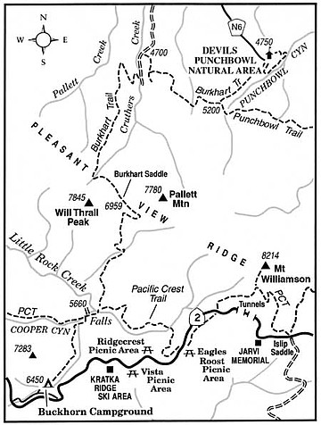
Traverse the San Gabriel Mountains from Angeles Crest to desert bottom on the rugged Burkhart Trail.
Far from sight and sound of the city, the Burkhart Trail blazes a lonely path over the desert bordering range of the San Gabriel Mountains and down into the upper margins of the Mojave Desert. Here the clean, dry air bears the melded exudations of both pines and desert sage. Although the route is superbly scenic, stretching between the Angeles Crest and Devil's Punchbowl Natural Area, relatively few hikers make the significant climb and long descent. The route features 2000 feet of cumulative elevation gain and 3700 feet of cumulative elevation descent.
You'll need to solve some transportation challenges first. Arrange to have someone drop you off at the start, Buckhorn Campground off Angeles Crest Highway, and pick you up later at Devil's Punchbowl -- perhaps five to seven hours later, depending on how strong your hiking party is. You reach the campground by driving 34 miles up Angeles Crest Highway (Highway 2) from Interstate 210 at La Cañada. Devil's Punchbowl is seven miles southeast of the town of Pearblossom in the Mojave Desert. The shortest way by pavement between the start and end points is an eastern route by way of Big Pines and Big Pines Road, but this year a section of Angeles Crest Highway near Big Pines has been plagued with rock slides. Check with Angeles National Forest or Caltrans to determine if this section is open; if not, the route by car is back to La Cañada and then by way of Palmdale.
From the far end of Buckhorn Campground, pick up the Burkhart Trail and descend 1.5 miles to join the Pacific Crest Trail. Turn right to follow the combined PCT/Burkhart Trail, passing the agreeably scenic Cooper Canyon falls singing in a ravine to the left. Cross Cooper Canyon's stream at 1.7 miles and bear left (PCT goes right) on the Burkhart Trail.
Now you commence a long climb to Burkhart Saddle -- a gap on the high crest of Pleasant View Ridge, the desert-bordering ridge of the San Gabriel Mountains. You wind steadily upward on sparsely forested slopes resplendent with blue and white lupines, red and blue penstemons, sunflowers, and other wildflowers. Little Rock Creek lies below, its stream coursing through a thirsty-looking gorge.
A series of long switchbacks precedes your arrival at Burkhart Saddle. If you are ahead of schedule at this point, consider bagging the nearby Pallett Mountain or Will Thrall Peak summits. Both feature expansive views of the broad, brown Mojave Desert floor to the north.
Down the other side, conifer forest grades into chaparral as you drop north down along a canyon wall overlooking the upper gorge of Cruthers Creek. After a couple of zigzags near the bottom you join a ranch road (8.3 miles). Its crooked course takes you down along the creek, then east onto a gently sloping hillside. Keep an eye out for the signed Burkhart Trail on the right, which departs from the ranch road and heads east toward Devil's Punchbowl Natural Area.
You climb about 500 feet, then contour for almost two miles across the northern spurs of the San Gabriels, passing an agreeable mix of cactus, sage, chaparral, and scattered pines. At 11.5 miles bear left on the signed Burkhart Trail (Punchbowl Trail continues straight ahead) and walk the remaining short mile to the parking lot at Devil's Punchbowl Natural Area.
Here's something you might be interested in.
Traverse the San Gabriel Mountains from Angeles Crest to desert bottom on the rugged Burkhart Trail.
Traverse the San Gabriel Mountains from Angeles Crest to desert bottom on the rugged Burkhart Trail.
Far from sight and sound of the city, the Burkhart Trail blazes a lonely path over the desert bordering range of the San Gabriel Mountains and down into the upper margins of the Mojave Desert. Here the clean, dry air bears the melded exudations of both pines and desert sage. Although the route is superbly scenic, stretching between the Angeles Crest and Devil's Punchbowl Natural Area, relatively few hikers make the significant climb and long descent. The route features 2000 feet of cumulative elevation gain and 3700 feet of cumulative elevation descent.
You'll need to solve some transportation challenges first. Arrange to have someone drop you off at the start, Buckhorn Campground off Angeles Crest Highway, and pick you up later at Devil's Punchbowl -- perhaps five to seven hours later, depending on how strong your hiking party is. You reach the campground by driving 34 miles up Angeles Crest Highway (Highway 2) from Interstate 210 at La Cañada. Devil's Punchbowl is seven miles southeast of the town of Pearblossom in the Mojave Desert. The shortest way by pavement between the start and end points is an eastern route by way of Big Pines and Big Pines Road, but this year a section of Angeles Crest Highway near Big Pines has been plagued with rock slides. Check with Angeles National Forest or Caltrans to determine if this section is open; if not, the route by car is back to La Cañada and then by way of Palmdale.
From the far end of Buckhorn Campground, pick up the Burkhart Trail and descend 1.5 miles to join the Pacific Crest Trail. Turn right to follow the combined PCT/Burkhart Trail, passing the agreeably scenic Cooper Canyon falls singing in a ravine to the left. Cross Cooper Canyon's stream at 1.7 miles and bear left (PCT goes right) on the Burkhart Trail.
Now you commence a long climb to Burkhart Saddle -- a gap on the high crest of Pleasant View Ridge, the desert-bordering ridge of the San Gabriel Mountains. You wind steadily upward on sparsely forested slopes resplendent with blue and white lupines, red and blue penstemons, sunflowers, and other wildflowers. Little Rock Creek lies below, its stream coursing through a thirsty-looking gorge.
A series of long switchbacks precedes your arrival at Burkhart Saddle. If you are ahead of schedule at this point, consider bagging the nearby Pallett Mountain or Will Thrall Peak summits. Both feature expansive views of the broad, brown Mojave Desert floor to the north.
Down the other side, conifer forest grades into chaparral as you drop north down along a canyon wall overlooking the upper gorge of Cruthers Creek. After a couple of zigzags near the bottom you join a ranch road (8.3 miles). Its crooked course takes you down along the creek, then east onto a gently sloping hillside. Keep an eye out for the signed Burkhart Trail on the right, which departs from the ranch road and heads east toward Devil's Punchbowl Natural Area.
You climb about 500 feet, then contour for almost two miles across the northern spurs of the San Gabriels, passing an agreeable mix of cactus, sage, chaparral, and scattered pines. At 11.5 miles bear left on the signed Burkhart Trail (Punchbowl Trail continues straight ahead) and walk the remaining short mile to the parking lot at Devil's Punchbowl Natural Area.