Here's something you might be interested in.
Ask a Hipster — Advice you didn't know you needed
Big Screen — Movie commentary
Blurt — Music's inside track
Booze News — San Diego spirits
Classical Music — Immortal beauty
Classifieds — Free and easy
Cover Stories — Front-page features
Drinks All Around — Bartenders' drink recipes
Excerpts — Literary and spiritual excerpts
Feast! — Food & drink reviews
Feature Stories — Local news & stories
Fishing Report — What’s getting hooked from ship and shore
From the Archives — Spotlight on the past
Golden Dreams — Talk of the town
The Gonzo Report — Making the musical scene, or at least reporting from it
Letters — Our inbox
Movies@Home — Local movie buffs share favorites
Movie Reviews — Our critics' picks and pans
Musician Interviews — Up close with local artists
Neighborhood News from Stringers — Hyperlocal news
News Ticker — News & politics
Obermeyer — San Diego politics illustrated
Outdoors — Weekly changes in flora and fauna
Overheard in San Diego — Eavesdropping illustrated
Poetry — The old and the new
Reader Travel — Travel section built by travelers
Reading — The hunt for intellectuals
Roam-O-Rama — SoCal's best hiking/biking trails
San Diego Beer — Inside San Diego suds
SD on the QT — Almost factual news
Sheep and Goats — Places of worship
Special Issues — The best of
Street Style — San Diego streets have style
Surf Diego — Real stories from those braving the waves
Theater — On stage in San Diego this week
Tin Fork — Silver spoon alternative
Under the Radar — Matt Potter's undercover work
Unforgettable — Long-ago San Diego
Unreal Estate — San Diego's priciest pads
Your Week — Daily event picks
Discover a showery 20-foot cascade in Coal Canyon, Orange County's premier wildlife corridor.
For at least three decades, the Coal Canyon diamond interchange on the Riverside Freeway through Santa Ana Canyon was a virtual joke, featuring ramps to and from nowhere. "Nowhere" might have been replaced by subdivisions spreading eastward from Yorba Linda and Anaheim Hills. That hasn't happened, and likely will never happen. The Coal Canyon undercrossing, it was discovered, was the one and only practical wildlife corridor between 40,000 acres of undeveloped lands in the Chino and Puente Hills to the north and half a million acres of wild land in the Santa Ana Mountains to the south. Mountain lions were using it to avoid being flattened by an endless river of cars, 10 to 12 lanes wide. Biologists increasingly insist that preserving habitat linkages, even lowly ones such as freeway crossings and tunnels, are essential to the regional survival of migratory wild animals.
Coal Canyon's freeway ramps were closed in 2003. The asphalt strip of the putative parkway underneath is gone, and a wide stretch of Coal Canyon south of the freeway is now friendlier to both migrating creatures and hikers curious enough to visit. Formerly under private ownership, the canyon has fallen under the jurisdiction of Chino Hills State Park and California's Department of Fish and Game.
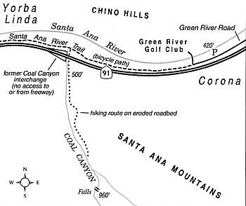
To get to the present starting point of the Coal Canyon hike from central San Diego, use Interstate 5 and Orange County's Eastern Transportation Corridor toll road to reach Highway 91 (Riverside Freeway). Travel east four miles to the Green River Road exit, and turn left (west). After one mile, park on the right side of Green River Road where space is available at a point 0.2 mile short of the entrance to the Green River Golf Club. (Note: It is faster for residents of north inland San Diego County to follow Interstate 15 north to Corona, and Highway 91 west to Green River Road.)
On foot, walk the 0.2 mile stretch along Green River Road toward the golf course entrance, and continue on the paved Santa Ana River bike trail that closely parallels the freeway. Endure for the next few minutes the insanely roaring traffic on your left. Also, take note of the massive damage to the Santa Ana River concrete flood channel on your right, due to near-catastrophic flows of water in recent months. Construction crews will likely be active in this area for several months to come.
When you reach the Coal Canyon crossing after 1.2 miles, walk underneath the overpasses and continue south into Chino Hills State Park territory (signs say no bikes and no dogs allowed). Follow an old, often eroded truck trail up Coal Canyon's wide floodplain, staying to the left of the canyon's sand-and-gravel-coated stream bed.
After a mile of uphill hiking, just short of where the canyon significantly narrows, you'll need to drop down onto the gravelly canyon floor itself. Proceed one-half mile farther upstream, following a silvery strand of water, to where the canyon walls soar and pinch in tightly. There, the sound of spattering water heralds your arrival at a sublime grotto graced with a 20-foot high shower of crystal-clear water. It pours off a mineralized outcrop shaped like the spout of a teapot. This is a rare sight -- but so, too, is this season's overabundance of rain.
Here's something you might be interested in.
Discover a showery 20-foot cascade in Coal Canyon, Orange County's premier wildlife corridor.
Discover a showery 20-foot cascade in Coal Canyon, Orange County's premier wildlife corridor.
For at least three decades, the Coal Canyon diamond interchange on the Riverside Freeway through Santa Ana Canyon was a virtual joke, featuring ramps to and from nowhere. "Nowhere" might have been replaced by subdivisions spreading eastward from Yorba Linda and Anaheim Hills. That hasn't happened, and likely will never happen. The Coal Canyon undercrossing, it was discovered, was the one and only practical wildlife corridor between 40,000 acres of undeveloped lands in the Chino and Puente Hills to the north and half a million acres of wild land in the Santa Ana Mountains to the south. Mountain lions were using it to avoid being flattened by an endless river of cars, 10 to 12 lanes wide. Biologists increasingly insist that preserving habitat linkages, even lowly ones such as freeway crossings and tunnels, are essential to the regional survival of migratory wild animals.
Coal Canyon's freeway ramps were closed in 2003. The asphalt strip of the putative parkway underneath is gone, and a wide stretch of Coal Canyon south of the freeway is now friendlier to both migrating creatures and hikers curious enough to visit. Formerly under private ownership, the canyon has fallen under the jurisdiction of Chino Hills State Park and California's Department of Fish and Game.
To get to the present starting point of the Coal Canyon hike from central San Diego, use Interstate 5 and Orange County's Eastern Transportation Corridor toll road to reach Highway 91 (Riverside Freeway). Travel east four miles to the Green River Road exit, and turn left (west). After one mile, park on the right side of Green River Road where space is available at a point 0.2 mile short of the entrance to the Green River Golf Club. (Note: It is faster for residents of north inland San Diego County to follow Interstate 15 north to Corona, and Highway 91 west to Green River Road.)
On foot, walk the 0.2 mile stretch along Green River Road toward the golf course entrance, and continue on the paved Santa Ana River bike trail that closely parallels the freeway. Endure for the next few minutes the insanely roaring traffic on your left. Also, take note of the massive damage to the Santa Ana River concrete flood channel on your right, due to near-catastrophic flows of water in recent months. Construction crews will likely be active in this area for several months to come.
When you reach the Coal Canyon crossing after 1.2 miles, walk underneath the overpasses and continue south into Chino Hills State Park territory (signs say no bikes and no dogs allowed). Follow an old, often eroded truck trail up Coal Canyon's wide floodplain, staying to the left of the canyon's sand-and-gravel-coated stream bed.
After a mile of uphill hiking, just short of where the canyon significantly narrows, you'll need to drop down onto the gravelly canyon floor itself. Proceed one-half mile farther upstream, following a silvery strand of water, to where the canyon walls soar and pinch in tightly. There, the sound of spattering water heralds your arrival at a sublime grotto graced with a 20-foot high shower of crystal-clear water. It pours off a mineralized outcrop shaped like the spout of a teapot. This is a rare sight -- but so, too, is this season's overabundance of rain.
Comments