Here's something you might be interested in.
Ask a Hipster — Advice you didn't know you needed
Big Screen — Movie commentary
Blurt — Music's inside track
Booze News — San Diego spirits
Classical Music — Immortal beauty
Classifieds — Free and easy
Cover Stories — Front-page features
Drinks All Around — Bartenders' drink recipes
Excerpts — Literary and spiritual excerpts
Feast! — Food & drink reviews
Feature Stories — Local news & stories
Fishing Report — What’s getting hooked from ship and shore
From the Archives — Spotlight on the past
Golden Dreams — Talk of the town
The Gonzo Report — Making the musical scene, or at least reporting from it
Letters — Our inbox
Movies@Home — Local movie buffs share favorites
Movie Reviews — Our critics' picks and pans
Musician Interviews — Up close with local artists
Neighborhood News from Stringers — Hyperlocal news
News Ticker — News & politics
Obermeyer — San Diego politics illustrated
Outdoors — Weekly changes in flora and fauna
Overheard in San Diego — Eavesdropping illustrated
Poetry — The old and the new
Reader Travel — Travel section built by travelers
Reading — The hunt for intellectuals
Roam-O-Rama — SoCal's best hiking/biking trails
San Diego Beer — Inside San Diego suds
SD on the QT — Almost factual news
Sheep and Goats — Places of worship
Special Issues — The best of
Street Style — San Diego streets have style
Surf Diego — Real stories from those braving the waves
Theater — On stage in San Diego this week
Tin Fork — Silver spoon alternative
Under the Radar — Matt Potter's undercover work
Unforgettable — Long-ago San Diego
Unreal Estate — San Diego's priciest pads
Your Week — Daily event picks
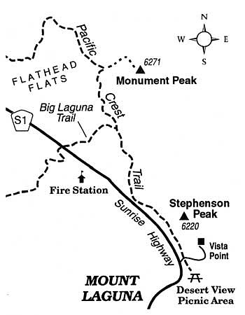
Check out a comprehensive mountain and desert view from the 6000+ foot summit of Monument Peak in the Laguna Mountains.
San Diego County is riddled with edges or "ecotones" -- boundaries between different geographic regions or ecological habitats. Ecotones harbor great biological diversity and often feature spectacular scenery, especially when the transition from one type of landscape to another is abrupt. Ecotones abound at the ocean's edge, where coastal sage scrub changes into coastal strand or rocky shore habitat and that in turn grades into the intertidal zone. Another major ecotone snakes its way along the county's peaked roof -- the top of the Peninsular Ranges some 40 to 50 miles inland. In places, a strip of land just a few hundred feet wide separates cool plateau forests from steeply plunging slopes falling straightway to the desert floor.
A 40-minute stroll through pine woods and windblown chaparral in the Laguna Mountains suffices to take you to Monument Peak, smack-dab on the mountain-desert ecotone. A small cluster of communication antennas rests on Monument Peak, a testament to the mountain's strategic geographic position. Few hikers come this way; as a result, the shortest route to the summit is obscure and requires a bit of navigational attention.
From San Diego drive east on Interstate 8 to Sunrise Highway, and follow Sunrise Highway north about ten miles to mile 25.2 (according to the small green highway mile markers posted every half mile). Park off the pavement on the right (east) side of the road, and start walking uphill on the signed Big Laguna Trail. Initially, you traverse an area dotted with Jeffrey pines and black oaks that was spared in both the 2002 Pines Fire and the 2003 Cedar Fire conflagrations. Proceed 0.5 mile uphill to a junction with the Pacific Crest Trail. Turn left, and continue moderately uphill, counting your paces as you go. After about 800 steps, you get a glimpse of microwave antennas ahead. This is an important clue. At the next sharp leftward bend in the trail, keep going straight on an informal path up the rocky slope. Soon, the path bends to the right and you clamber up to and around a fenced laser-research facility to join a paved access road that is closed to public automobile traffic.
Follow that road to Monument Peak's summit, where the vista of earth and sky spreads incredibly far and wide, particularly around the beginning and the end of each clear day. Early in the day, the sun vaults above a bluish horizon shaped by Arizona peaks. Late in the afternoon, Laguna Mountain shadows lengthen across the floor of the Anza-Borrego Desert, racing ever faster over sandy flats and badlands a mile in elevation below.
Here's something you might be interested in.
Check out a comprehensive mountain and desert view from the 6000+ foot summit of Monument Peak in the Laguna Mountains.
Check out a comprehensive mountain and desert view from the 6000+ foot summit of Monument Peak in the Laguna Mountains.
San Diego County is riddled with edges or "ecotones" -- boundaries between different geographic regions or ecological habitats. Ecotones harbor great biological diversity and often feature spectacular scenery, especially when the transition from one type of landscape to another is abrupt. Ecotones abound at the ocean's edge, where coastal sage scrub changes into coastal strand or rocky shore habitat and that in turn grades into the intertidal zone. Another major ecotone snakes its way along the county's peaked roof -- the top of the Peninsular Ranges some 40 to 50 miles inland. In places, a strip of land just a few hundred feet wide separates cool plateau forests from steeply plunging slopes falling straightway to the desert floor.
A 40-minute stroll through pine woods and windblown chaparral in the Laguna Mountains suffices to take you to Monument Peak, smack-dab on the mountain-desert ecotone. A small cluster of communication antennas rests on Monument Peak, a testament to the mountain's strategic geographic position. Few hikers come this way; as a result, the shortest route to the summit is obscure and requires a bit of navigational attention.
From San Diego drive east on Interstate 8 to Sunrise Highway, and follow Sunrise Highway north about ten miles to mile 25.2 (according to the small green highway mile markers posted every half mile). Park off the pavement on the right (east) side of the road, and start walking uphill on the signed Big Laguna Trail. Initially, you traverse an area dotted with Jeffrey pines and black oaks that was spared in both the 2002 Pines Fire and the 2003 Cedar Fire conflagrations. Proceed 0.5 mile uphill to a junction with the Pacific Crest Trail. Turn left, and continue moderately uphill, counting your paces as you go. After about 800 steps, you get a glimpse of microwave antennas ahead. This is an important clue. At the next sharp leftward bend in the trail, keep going straight on an informal path up the rocky slope. Soon, the path bends to the right and you clamber up to and around a fenced laser-research facility to join a paved access road that is closed to public automobile traffic.
Follow that road to Monument Peak's summit, where the vista of earth and sky spreads incredibly far and wide, particularly around the beginning and the end of each clear day. Early in the day, the sun vaults above a bluish horizon shaped by Arizona peaks. Late in the afternoon, Laguna Mountain shadows lengthen across the floor of the Anza-Borrego Desert, racing ever faster over sandy flats and badlands a mile in elevation below.