Here's something you might be interested in.
Ask a Hipster — Advice you didn't know you needed
Big Screen — Movie commentary
Blurt — Music's inside track
Booze News — San Diego spirits
Classical Music — Immortal beauty
Classifieds — Free and easy
Cover Stories — Front-page features
Drinks All Around — Bartenders' drink recipes
Excerpts — Literary and spiritual excerpts
Feast! — Food & drink reviews
Feature Stories — Local news & stories
Fishing Report — What’s getting hooked from ship and shore
From the Archives — Spotlight on the past
Golden Dreams — Talk of the town
The Gonzo Report — Making the musical scene, or at least reporting from it
Letters — Our inbox
Movies@Home — Local movie buffs share favorites
Movie Reviews — Our critics' picks and pans
Musician Interviews — Up close with local artists
Neighborhood News from Stringers — Hyperlocal news
News Ticker — News & politics
Obermeyer — San Diego politics illustrated
Outdoors — Weekly changes in flora and fauna
Overheard in San Diego — Eavesdropping illustrated
Poetry — The old and the new
Reader Travel — Travel section built by travelers
Reading — The hunt for intellectuals
Roam-O-Rama — SoCal's best hiking/biking trails
San Diego Beer — Inside San Diego suds
SD on the QT — Almost factual news
Sheep and Goats — Places of worship
Special Issues — The best of
Street Style — San Diego streets have style
Surf Diego — Real stories from those braving the waves
Theater — On stage in San Diego this week
Tin Fork — Silver spoon alternative
Under the Radar — Matt Potter's undercover work
Unforgettable — Long-ago San Diego
Unreal Estate — San Diego's priciest pads
Your Week — Daily event picks
The San Diego Bird Atlas Project
479 three-mile squares surveyed
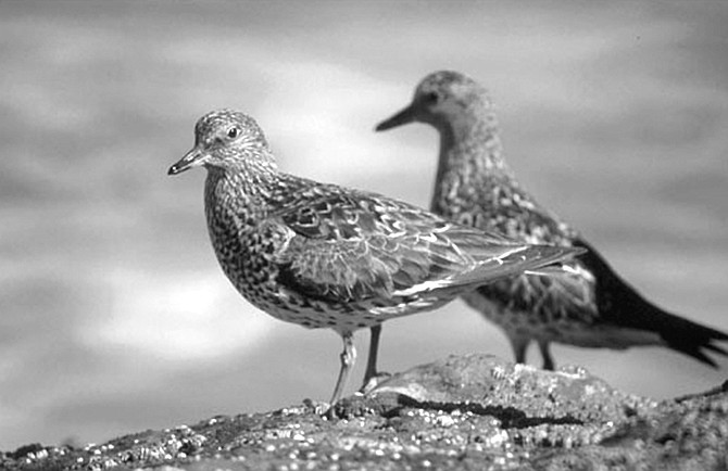
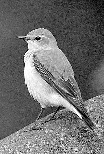
“One, two, three, four, five, six, seven surfbirds. They’re the little fat birds with the yellow legs and yellowish beaks."
A steer skeleton lay in the dry creek bed. Tom extracted a tooth from its skull and handed it to me like a picked flower. Its roots were long and brown, so desiccated they looked almost wooden. Only its crown was any bit of white. I slipped the gift into my backpack — a souvenir of square V17.
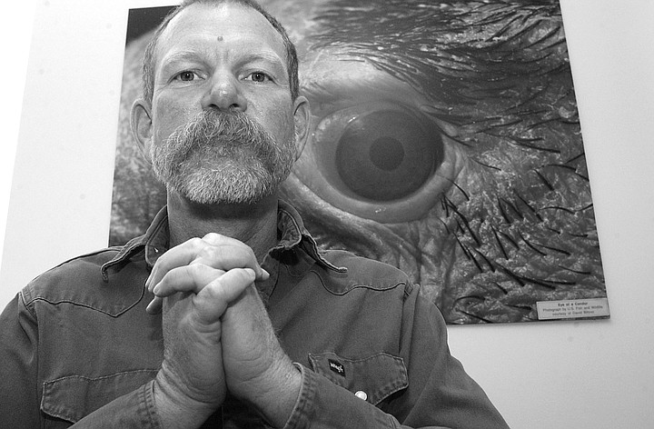
Philip Unitt: “A group of us talked about doing an atlas in 1978. But as time went on, the other people fell by the wayside until I was the only one left."
Tom's wife, Ann, said that things had changed completely since the last time she and Tom were here in V17. "In the spring, this was neck-high grasses! We got lost, separated from each other a couple of times. We were tripped by the logs that were hidden and fell on our faces. It was difficult to find a true path; eventually you'd find that it was a false path. We practically had to hack our way through here with our bare hands. A machete would have come in handy." She lifted her binoculars. "There's a California towhee," she said, pointing the lenses at a place on the ground about 100 yards away. "They're around our house in La Mesa. They come right into the garage. The cats wish they could have them."
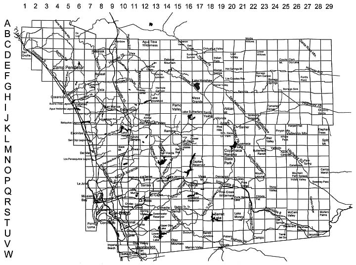
San Diego County Bird Atlas grid. "For the bird atlas we set up our grid and tried to sample each cell to some minimum threshold."
As Ann wrote in a small spiral-bound notebook, I found the towhee with my own binoculars. What I saw was a chubby, gray-brown, robin-sized bird with a rust-streaked breast, a conical beak, and a way of foraging that made me think it was annoyed. Using both its beak and feet, it hunted for seed in the short, dead grasses. Despite its vexed manner, I envied the bird its lack of distractions and its purposefulness. It would never think of spying on me.
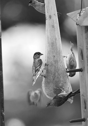
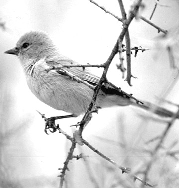
Goldfinch. “We usually see just the lesser goldfinch, a more common species that shows up here.”
But the Keenans have a purpose here too; they’re not just birding for idle pleasure. They’re collecting data for the San Diego County Bird Atlas. “Citizen science” is one name I’ve seen to describe projects that use volunteers who engage in fieldwork under the supervision of the professionals who recruit them. Tom’s background isn’t biology: he retired early, 15 years ago, from his job as an electrical engineer (or “double e,” as he says); at the same time, Ann left hers as a computer scientist. Together they started exploring things. In 1988, they took their first birding course from a local chapter of the Audubon Society. “As far as we’re concerned,” Tom told me, “birds entered the planet that year.”
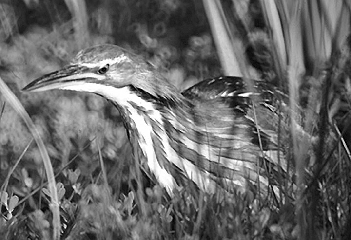
They saw a pair of American Bitterns at Camp Pendleton, along with a juvenile, hiding in cattails. “It’s like a heron or an egret, but short-legged, and its breast is streaked with white and tan.”
V17, as it’s known on the bird-atlas grid of the county, is a three-by-three-mile square close to the border near Tecate. On our way to it we took a dirt road that became a washboard road. Our voices vibrated as we rode along in the Keenans’ 1999 black Mercedes SUV. The part of the square that we were on now was grazing land. We could see the herd in a distant pasture; later we would almost stumble into a stray herd member who was sitting as still as a big, black boulder under a live oak tree. Tom pointed out that all the oaks in the area were trimmed up to steer-mouth height and that no smaller ones grew underneath them: the steers had eaten the seedlings too. Meanwhile, Ann spotted lark sparrows feeding under one of those oaks and wrote in her notebook again.
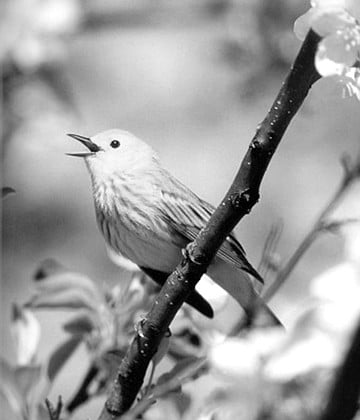
Yellow warbler: "We recorded only a single instance of cowbird parasitism on the Yellow Warbler — a female feeding a fledgling cowbird in Kit Carson Park."
The smell in the air was the sea at low tide. The Tecate and Cottonwood Creeks come together in V17, then flow into the Tijuana River. The land is owned by the San Diego County Water Authority — a rancher rents it — and the Keenans and I needed permission to be on it, along with a key to unlock the gate. They hadn’t bothered to put their official sign on the windshield: “Bird Atlas. Volunteers Conducting Bird Survey. A Project of the Biodiversity Research Center of the Californias of the San Diego Natural History Museum.” The Border Patrol had probably already seen us with our birding gear anyway. Their cars occasionally appeared on the cliffs above us, and their helicopters sometimes passed overhead.
Susan Smith made an even more significant find; she sighted a Northern wheatear during a lunch-hour walk in Torrey Pines.
The Keenans signed up for the bird-atlas project as soon as it began, on February 22, 1997. When the results of the five years of fieldwork are published by the museum, as a series of color-coded maps with detailed commentary, we will know exactly what birds were where — and when — and what they were doing during the five-year period that ended on February 28, 2002. A comparison of this fresh data with available historical data will reveal how distributions have changed over the past century. We’ll also know which birds are adapting to urbanization and “habitat fragmentation” — and which ones aren’t.
Northern wheatear. The wheatear “barely enters North America.”
The project isn’t unique. Bird-atlas work has been conducted in Europe since the mid-1960s. In the United States, the first results of bird-atlas surveys were published by Vermont and Maryland in the 1970s. The California counties of Marin, Monterey, and Sonoma have published bird atlases recently. Fieldwork for the bird atlases of several other counties in the state is underway. And San Diego itself has had a forerunner to this current project; the results were published by the museum in 1984 as The Birds of San Diego County.
Ann and I saw a verdin eating insects off a creosote bush.
Philip Unitt, collection manager of the museum’s birds and mammals department, was the author of that earlier study and did most of the fieldwork for it himself. That wasn’t what he had intended to happen. “A group of us talked about doing an atlas in 1978,” he told me in his office one day. “But as time went on, the other people fell by the wayside until I was the only one left. We all realized an atlas was needed; the latest thing available was from the 1950s.”
Rich and Susan Breisch. Susan: "All of a sudden a Border Patrol vehicle comes up out of nowhere, and he doesn’t look at our faces. He’s looking at our feet. And he says something like, ‘Oh, darn. I’ve been tracking you.’ ”
Unitt’s reference is to the 1959 annotated list of birds in San Diego County compiled by James R. Sams and Ken Stott. Forty years earlier, Frank Stephens (1849–1937), a self-taught ornithologist, compiled the first list for the region. In 1924, Stephens became the San Diego Natural History Museum’s director; his collection of study skins formed the nucleus of the museum’s collection.
Unitt, whose job is to oversee that collection today, will be the author of the forthcoming volume. But having recruited a core of 200 consistent long-term data collectors like the Keenans, he has been able to be much more ambitious than anyone at any previous time, including his younger self. In fact, the new project is acknowledged by some experts to be one of the most ambitious bird-atlas projects in the world. That’s because it will include birds that winter here as well as birds that breed here. There’s a good reason to include them: more species spend winters in San Diego than breed here. The latest British studies have included winter birds, and a few other places around the world are starting to do the same. But the winter portion of the San Diego project is among the first for North America. It is definitely the first for California — and is likely to be precedent setting.
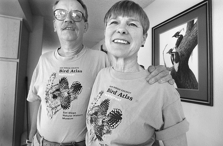
Not every good birder in San Diego has been involved. “A certain number of people with adequate birding skills flunked the paperwork,” Unitt said. Reams of it have been required. A couple who, like the Keenans, have been among the most loyal participants showed me the biggest, thickest three-ring binders I had ever seen when I interviewed them at their home. The binders were filled over the five-year period with copies of their bird-atlas forms.
I looked at some of those forms that volunteers were required to submit to the project. They made it clear that bird-atlas work was no mere walk in the woods. The Winter Record Form (which isn’t even as complicated as the form required during breeding season) lists six columns of bird species, about 300 in all. “Specify a single date” for your sighting, the instructions say. “Enter count or estimate of number observed in square in one day. Enter a specific number, even if just an estimate, rather than a range or order of abundance level. Estimate the abundance level only when you have achieved the threshold criteria for covering the square. Abundance level: E1, 1–10; E2, 10–100; E3, 100–1000; E4, 1000–10,000. If a more accurate estimate or count is possible, enter it without the ‘E’ prefix.” Some of the species have asterisks after their names. For those one must plot the precise location of the sighting on another form, the Daily Field Map.
To be committed participants, birders needed something else besides tolerance for tedium. They needed to be free from their own long-term birding goals and interests — rare-bird sightings, for example.
(Even if some of the county’s great birders didn’t adopt a square and weren’t working specifically for the bird atlas, they were constantly feeding data into it. In addition, the last five years of Christmas bird counts, sponsored by the National Audubon Society, have been folded into the bird-atlas data. Same goes for the Breeding Bird Survey, sponsored by the U.S. Geological Survey and conducted by volunteers.)
Those who signed on for the full term of the project also had to believe in its usefulness as a conservation “tool.” That tool would logically take the form of maps, because any bird that gets listed as an endangered species is put into geographical context: the area considered essential to its survival must be listed along with it, as a critical habitat.
“San Diego’s Multiple Species Conservation Program advertises itself as being able to preserve species while at the same time it alleviates the conflict between development and conservation,” said Unitt. “It will consign substantial areas to development all at once as well as to conservation all at once.” Whether it will actually accomplish these goals won’t be known for some time. “What it amounts to is a big experiment. Well, with an experiment you need a control group.”
Portraying the bird atlas as that control group was, he said, one of his primary means of marketing the project to both funding sources and volunteers. “Other monitoring programs have been proposed, and I’m not sure what has been decided, because a lot goes on inside the bureaucracy of the U.S. Fish and Wildlife Service which I’m not privy to. But we were fortunate that many people bought into the bird-atlas idea and saw the value of its approach.”
It was “bought” literally, since the project is being paid for by more than $600,000 of grants and contracts as well as cooperative agreements from the Cleveland National Forest, California State Parks, California Department of Transportation, Zoological Society of San Diego, National Fish and Wildlife Foundation, U.S. Department of the Navy, California Department of Fish and Game, San Diego Unified Port District, and San Diego Foundation. Another $30,000 came from individual donations and from local groups, including the Palomar Audubon Society and the San Diego Audubon Society. The estimated worth of the fieldwork by the volunteers is more than $700,000. Another $100,000 is being sought for publication expenses.
The three- by three-mile square is standard for bird atlases. The fine scale was essential for San Diego, Unitt said, because of the diversity of its habitat and its endemism, an ecological term meaning native to or confined to a certain region. “A hundred and fifty years ago, when the first naturalists were starting to visit the West, it was like ‘Location: California.’ They didn’t yet know that one mountain or one river could be different from the next. That knowledge took decades to accumulate. A plant example is one species of yucca relative, Nolina interrata. It grows on something like five peaks in central San Diego County in a certain soil type. If there’s going to be effective conservation, obviously you want to emphasize the peaks that are relevant. So for the bird atlas we set up our grid and tried to sample each cell to some minimum threshold. That’s the fundamental principle behind our project.”
Birding is acknowledged to be a mental challenge. “It’s an intellectual exercise,” Ann Keenan told me while we were in V17. “You have to put a lot of information together to make the identifications.” But a project of this scope — designed to cover the whole county, the remotest and most rugged parts of which few people had ever seen and no ornithologists had ever studied — has also been an extraordinary physical challenge for many volunteers.
“Five days out of the last seven I’ve been on ten-mile hikes,” the 60-year-old Ann told me on the phone one day last spring, six months before we met. “I’ve been birding in really remote parts of the county. What people for this project do is adopt a square. They’re responsible for reporting on the birding activity there. Many squares in the remotest spots weren’t adopted by anybody. So now we have what we call blockbusters, where a group of us do the square. Last weekend I helped do a square that we had to hike two and a half miles just to reach. There were a few squares Phil was ready to give up on. He thought nobody was going to get there. But everybody is pitching in, and we’re all learning about these places we would never have known about otherwise.”
The number of squares is 479. The A’s start in the north; the W’s are the southernmost row. The numbers start in the west and move eastward, from 1 to 29. So you can approximate a square’s location if you know its number and letter. Each square was also given a name based on a landmark within its borders. Some squares on the eastern edge of the county have lyrical landmark names, perhaps the better to entice volunteers to adopt them — “Well of Eight Echoes,” for example, and “Hills of the Moon Wash.” Other landmark names — “Thing Valley,” “Arsenic Spring,” and “Hellhole Canyon” — don’t pretend to be luring.
The landmark name for V17 is the relatively neutral “Little Tecate Peak.” No one had adopted it; the Keenans were part of a blockbuster whenever they went there. The terrain wasn’t the reason why it needed a blockbuster. As Unitt explained it, touching on other challenges of the project: “V17 wasn’t difficult to get to, provided you made arrangements ahead of time to pick up the key, had a vehicle you were comfortable driving on dirt roads, and weren’t intimidated by the nearness of the Mexican border, at a point where armed drug smugglers could easily slip across. It actually wasn’t until the last year of the project that we found out we could get the key to the gate on the line between U17 [‘Engineer Springs’] and V17 from the Bureau of Land Management. Previously, we’d had to borrow a key from the rancher who leases the land, a situation requiring much more diplomacy.” One project member went to a community meeting in Dulzura to familiarize people with the bird atlas. “His central goal was maintaining friendly relations with this lessee. Finding out how to negotiate some of these difficult areas took us years. Even if an area is owned by some more or less public agency, there may be all sorts of other obstacles to our just wandering in and looking at birds.”
Unitt knew that three squares in the Santa Rosa Mountains of Anza-Borrego Desert State Park — C27, C28, and D28 (“Villager Peak,” “Santa Rosa Mountains Northeast,” and “Santa Rosa Mountains Southeast”) — were so remote that one simply could not hope to drive out there, hike to the square, have time to bird, and carry enough water to make it out alive. It’s some of the steepest terrain in the county. So he and two others were helicoptered to those places. Lori Hargrove was one of those two. “It only took a few minutes from the Borrego Springs airport before we were looking down at the ridges we would be exploring,” the 36-year-old Hargrove wrote of her experiences for Wrenderings, the bird-atlas project’s quarterly newsletter. “After dropping Phil off at Villager Peak, the helicopter pilot wanted to know where to take me, so I motioned toward the range I was to cover just east of Rattlesnake Canyon and told him ‘anywhere you can find an open spot.’ We soon alighted gently in a small clearing next to a rocky peak. I got myself and gear out, waved goodbye, and while I squinted from the blowing sand watching him fly off, I wondered if he would be able to find this same spot three days from now.”
Securing permission to bird on Indian reservations posed a challenge of another sort. Each tribe reacted in its own way to requests from volunteers.
“I had anticipated the varying reactions,” said Unitt. “Their reputations were already known. For example, the La Jolla and the Los Coyotes reservations have public camping facilities, and as long as you pay the fee, there’s no problem gaining access.”
In the case of Los Coyotes, it was particularly important for the project to have this tribe’s cooperation. Six squares are either entirely or significantly within its borders. “And if we had not gotten on there, we simply wouldn’t have been able to cover those areas at all. So that was really good. They have been extremely friendly. In addition, the highest mountain in San Diego County is on their land, and in the 1980s, while working on the old book, I went to that mountain, the first birder or ornithologist ever to go there. Hot Springs Mountain. So this time we’ve been able to cover it much more thoroughly than I did. It spreads over four squares, E20 [‘Hot Springs Mountain West’], E21 [‘Hot Springs Mountain East’]; F20 [‘Eagle’s Nest’], and F21 [‘Los Coyotes’]. The summit is in E20, but the most interesting habitat is in E21. Two of our volunteers covered these squares for us very thoroughly, making some overnight owling trips as part of it.”
The Kumeyaay Indians, by contrast, were not cooperative, unfortunately for Unitt. “We just discovered a new colony of willow flycatchers up at El Capitan Reservoir, and now the Indians are patrolling around the reservoir and are not even — ” He paused, choosing his words. “We don’t want to antagonize them. We want to be friendly with them. See, the thing is that these requests have to go to their tribal councils, and then it gets ratcheted up to another level of politics. And I think a lot of it is done by consensus. And unless it has unanimous enthusiasm from everybody, which as a possibility is basically nil, nothing happens.”
In the end, for a variety of reasons, only three squares would prove to be unconquerable. One is D13, or “Frey Creek.” That square is mostly an extremely steep slope on Palomar Mountain belonging to the Pauma Indians and has no driving access. The second inaccessible square is C4 — yes, like the plastic explosive. It’s an appropriate designation: C4 is the bombing range of Camp Pendleton. (All the rest of Camp Pendleton was surveyed.) The third inaccessible square is D14. Also known as “French Valley,” D14 is not unreasonably rugged, but the way to it was blocked by someone Unitt described to me as a “xenophobic landowner.”
“Many squares have a lot of private property,” Unitt said, “and we have had to rely entirely on public-access roads or the goodwill of private-property owners to get to those places. And in San Diego we are on the front line of — ” He stopped himself. “I have been told not to use this expression, and you will not print it.”
I turned off my tape recorder. The man whose wit has been characterized by volunteers as “diabolical,” “mischievous,” and “creative” muttered the unprintable phrase. Suffice it to say it uses “private-property rights” and “state religion” in the same sentence.
Trying to be fair, Unitt acknowledged that “quite a number of friendly landowners” have “balanced out” the others — “all too many” — who said, “ ‘Get the hell out’ or ‘We don’t even want you walking on the public road in front of our property.’ ”
Not that landowners who have welcomed Unitt “with open arms” always endeared themselves to him. “One thing that gets me is people who use birds and other organisms as pawns in a battle that’s social and political and not biological,” he said. “There’s the example of the landowners who say, ‘Oh, can you find such-and-such a bird on my property and stop a power line, road, or whatever?’ People call the museum with questions like that all the time. Nobody likes going to endless hearings, lobbying their representatives, and duking it out with the opposition. But if you want a certain end, that’s what needs to be done. We should not expect some law like the Endangered Species Act to do our work for us. Besides, as a tactic, that has frequently been counterproductive, because it starts to antagonize the property owners against endangered species and against native wildlife plants. There have been episodes of landowners piling land over land just to kill everything.”
The materials that volunteers got when they signed up for a square included a form letter to landowners. They were instructed to use it or something similar when seeking permission to go birding on private property. “The volunteers will make arrangements with you at your convenience,” the letter says. “They go alone or in very small groups and are as quiet and unobtrusive as possible — this is the only way in which birds can be studied effectively. They will comply with whatever conditions you stipulate.”
Jack Gibson, spokesperson for Citizens for Private Property Rights, phoned and faxed a volunteer after members of his organization received copies of the letter from her. In a phone call to me, he said that some members have chased away birders with threats: “ ‘Don’t come on the property,’ they have said. ‘Your life might be in jeopardy.’ ”
Gibson was vague about where he lives, so I cannot name the square. He would say only that it’s “between Ramona and Santa Ysabel, probably closer to Santa Ysabel, in a very isolated area.” How many acres is it? “I’m not going to go into that. I will tell you that I’m at the end of a driveway a mile and three-quarters long. I have an ocean view, and I’m way inland. I don’t have neighbors. Step out my front door and you’re as rural as you’re going to get.”
Gibson, who speaks quickly and in the timbre of a radio talk-show host, wanted me to know that John James Audubon shot birds. “Piles and piles of them.” The artist was no conservationist, he said. As for himself: “I’m not someone who lives in the city and thinks nature is beautiful and should be protected. I’m someone who lives in nature. I respect nature as much as anyone you’re gonna find, but only within certain limits of, let’s say, the Constitution and capitalism. Surveys like [the bird atlas] are used against rural landowners. There are people who would try to impede progress on the bird atlas because the bird atlas is going to be used against them. And the people who come on the property will do everything they can to hurt these people — the rural landowners. People who live in the city don’t understand rural issues. They think the land out here should be totally preserved. I am well versed in ornithology, archaeology, natural history, as much as most people you might find. And I have a high respect for nature, but I don’t have a feel for people saying that fairy shrimp or kangaroo rats have precedence over people. I don’t have a good feel for that at all; in fact, I have a very, very bad feel, because once you say that you can’t touch your land because of things like that, we’re heading for Communism. That system doesn’t work. It’s tyranny.”
An instruction handbook is yet another paper item issued to volunteers. “Despite our best efforts,” the booklet says, “it’s inevitable that certain tracts, even important ones, of private property will remain inaccessible to us. There is no point in agonizing over this. We will cover the accessible areas best we can, use gentle persuasion to open as many areas as possible, and not worry about the rest. Remember, even in squares that are entirely public ownership, many areas won’t get covered. The project can only sample each square. Exhaustiveness is an unattainable ideal.”
Ann Keenan, for her part, gave me her shorthand assessment of the situation, and her solution: “You have to avoid the landowners. People don’t want a rare species to be found on their property.” The Keenans themselves, significantly, own a 700-acre ranch in the San Felipe Valley.
I met the Keenans for the first time in the parking lot of the Jamul post office on the day before we went to V17. We would be visiting another square on this opening day of the first blockbuster weekend of the project’s final winter season — a Saturday morning in early December under a blue sky marbled with pink and purple.
To get to Jamul I passed persimmons for sale, horses for rent, and Jake’s Drive-Through Espresso, as well as the usual number of highway construction sites. It’s easy to think of moveable concrete barriers (often called Jersey barriers) as ominous for birds. According to bird-atlas fieldwork, the California quail, for example, has been eliminated from R8, R9, S9, S10, and T10 (“Old Town,” “Mission Valley,” “Downtown San Diego,” “Greenwood/Mount Hope,” and “National City”), where there are historical records to prove the fact. It’s a good guess that the species, with its distinctive loop of a black plume topknot, has also been eliminated from Q7, R7, S8, S11, and U11 (“Pacific Beach,” “Ocean Beach,” “North Island,” “Encanto,” and “Chula Vista”), where there are no records from the past. The bird is beginning to disappear from H5, J11, and Q13 (“Oceanside,” “Escondido,” and “El Cajon”).
But not all species react negatively to development, according to a preliminary draft of Unitt’s analysis of the fieldwork. Lots of observant San Diegans have probably come to similar conclusions. Some birds have adapted remarkably well to the new conditions. House finches, Brewer’s blackbirds, and Anna’s hummingbirds are obvious cases. So is what’s perhaps San Diego’s most aggressive urban colonizer, the American crow. In addition, the spread of Nuttall’s woodpeckers has occurred in urbanized areas over the past 15 years. Cooper’s hawks are another species that has suddenly and dramatically taken up city living. House wrens and Western bluebirds are starting to move in, aided by back-yard birdhouses.
Urban adaptation doesn’t mean they’ll stay healthy city dwellers. Burrowing owls lived in drains along El Cajon Boulevard in the 1930s, the historical records show. Now they’re nearly absent from all of San Diego County, known to survive only precariously in parts of S8, at the Naval Air Station in “North Island”; V10, at Ream Field in “Imperial Beach”; and V13 and V14, whose landmark names are “Otay Mesa East” and “O’Neal Canyon.” Unitt considers these owls, who nest in abandoned animal burrows, the most endangered bird species in all of San Diego County.
About halfway through the fieldwork, Unitt detected a pattern in the adaptations: “Arboreal species that can take advantage of urban trees and live in a stratum above us people on the ground ultimately adapt to urbanization,” he wrote in a speech he gave to a meeting of professional wildlife biologists. “Terrestrial” and “undergrowth” species, on the other hand, “retreat.”
I met Unitt for the first time in Jamul, as he organized all of the dozen volunteers who had gathered that morning. The temperature was 34 degrees, and volunteer Susan Breisch, for one, wore earmuffs. She also wore her gardening gloves, lacking mittens to keep her hands warm. She and her husband Rich were the couple who would show me their giant three-ring binders when I interviewed them later in the week. That afternoon, Susan would go home to the warmth of their house in Tecolote Canyon, while Rich would camp out with Unitt and others in Potrero.
Unitt is 46 years old, slender but solidly built. He wore a broad-brimmed, navy-blue cowboy hat, one of his signature hats, I was told. Beneath the hat, his hair was reddish, to match his reddish-blond mustache and short beard. His chiseled jawline gave him the look of self-portraits of Vincent van Gogh. As he pointed to places on a map spread out on a car hood, it was hard not to think of another image: a general with his troops — a congenial general, with a courtly manner and a sonorous voice.
A native San Diegan, Unitt grew up in S10 (“Greenwood/Mount Hope”); his mother lives there still. S10 is one of his own personally adopted squares. He chose it for three reasons, he said. First, he didn’t anticipate that others would request an urban area, so he wanted to fill what might otherwise be a gap in the coverage. Second, the square was close to his home in Hillcrest and his office in Balboa Park, so he could cover it easily. Third, it gave him a chance to reacquaint himself with places where he began looking seriously at birds, for the first time, as a junior high school student.
Unitt lived in North Park for many years before moving to Hillcrest, so his habitat has always been “inner city,” he said. But his family, especially his mother, instilled in him a love of nature. “My mother grew up in complete poverty in Descanso. My grandmother’s husband was killed — he was a janitor in the school in Descanso. But anyway, she had an attachment to that area. And when I was a kid, we would go camping at Green Valley Falls in Cuyamaca State Park, just up the road from Descanso. That was our playground.
“It wasn’t until I was 13, though, that I picked up my mother’s bird book, which was a very crummy bird book, and wondered, ‘How many of these birds have I seen?’ Well, I could identify 30. I went on from there.”
Yes, he has. Today the number of birds on his “life list” (all birds ever seen anywhere) is well over 1000. To put this into perspective, consider that, while 70 million Americans are estimated to watch birds, fewer than 100 of them can claim 800 or more birds on their life lists. It’s also helpful to realize that the number of species on the American Bird Association’s checklist is 906. In other words, many birds on Unitt’s life list are those he has traveled to see in other parts of the world. (To put these counts into another sort of perspective, some 9000 bird species inhabit the earth.)
Unitt is respected by the volunteers not only for his knowledge but for his way of imparting it to them. “Un-show-offy” is a word I have heard used to describe him. Once, at a meeting, someone brought in a tape of a birdsong, and everyone was guessing that it was an indigo bunting. Phil was the only one who said quietly, “Lazuli bunting.” He was right. For the record, in the National Audubon Society’s Sibley Guide to Birds, the fine distinction between the two songs is noted: “Indigo Bunting: Voice: Song a high, sharp warble with most phrases repeated; quality musical and metallic ti ti whee whee zerre zerre (‘fire, fire where where here here’).” The lazuli’s song “averages slightly longer, higher, faster, and perhaps less repetitive than Indigo.”
The Breisches told me another story about their leader. “I won’t mention any names,” said Rich, “but when Phil was a teenager, a bird expert would just put down the amateurs and he put down Phil. So Phil said that if he ever got into the same position, he would never — ” Susan finished her husband’s thought: “ — behave that way and make people think they were worthless. We all crowd around Phil, like little kids: ‘Phil! Phil! Teacher! Teacher!’ And he gives you his attention: he’s so good at that. And I think it’s partly because of that experience he had as a young man, of being made to feel unimportant and ignorant, so he’s not going to do that to anyone else.”
Susan is a teacher herself, of third grade, so she knows whereof she speaks. (Her expressiveness and animated manner of speaking must be put to good use in her classroom.) Rich is a software engineer. For all of these citizen-scientists, birding is a hobby. I asked Unitt when a hobbyist-birder became an ornithologist. “Ah, well. It’s a question of semantics,” he said. “ ‘Birder’ implies that it’s a sport; ‘ornithologist’ implies that it’s a science. Now, of course, many people who are entirely amateur birders make an enormous contribution to science. In fact, that’s one of the things that our project is all about. There are also lots of ornithologists who enjoy birding recreationally, even if they don’t like to admit it. Ornithology is unique, because it’s one of the few sciences that maintain a continuum of highest-end Ph.D.s to people who may just look at birds at their back-yard feeder. Astronomy still has a heavy involvement of amateurs too. But most other sciences have gotten beyond the reach of people without specialized gadgetry. Field biology in general is one of the few places where the general public can still get a finger in the pie.”
I wondered aloud if Unitt himself had time for any non-birding-related hobbies. When I had looked over the list of squares and their adopters, I had seen his name appended to dozens besides S10. After thinking a moment, he said, “I enjoy cooking. I’m interested in languages and in history. But birds are — ” He thought again. “When I was in French Polynesia in 1991, I met a botanist — the San Diego Zoo had sent me there to search for ultramarine lorikeet — and I’ll never forget the botanist’s line: La botanique est une maîtresse exigeante. ‘Botany is a demanding mistress.’ It’s a phrase that can equally be applied to birding.”
The amateurs in San Diego County are less amateurish now. Maybe it happens to birders in every locale that undertakes a bird atlas. And yet this byproduct — a huge increase in birding skills among the participants — is something Unitt hadn’t anticipated. Still, he called it “one of the most gratifying aspects of the whole project.”
Partly it’s the result of the sheer number of hours volunteers have been required to spend in the field. (About 46,000 hours have been officially reported; thousands more were not.) The minimum number required per square was 25. And many of the most devoted volunteers had numerous squares. (The Keenans, for example, signed up for 5 initially, then added several more, in addition to participating in the blockbusters. The Breisches had at least 12.)
Partly, too, the improvements in skills were the result of the intensified observations required to confirm breeding. It’s no exaggeration to say that each spring for the duration of the project, evidence of the sex lives of birds in San Diego County was more scrutinized than ever before.
The instruction handbook lists behaviors that volunteers must have observed in order to make their breeding claims. Behaviors range from specific actions like nest-building to more subtle signs like territorial behavior. (“Use this category with caution,” the handbook states; “some species, like hawks and hummingbirds, will defend a feeding territory or favorite perch while wintering or migrating.”)
Of course, using volunteers, some of whom began with only average skills, meant that Unitt spent lots of time checking their reports. “Everything that got reported I reviewed,” he said. “And some things got crossed out. Other things people got grilled on, for further details.”
The Breisches had this to say about Unitt’s reviews of their submissions and of their own rigorous reporting techniques. “Rich is a real stickler for details,” said Susan, putting most of the onus for rigor on her husband.
“Susan would write half a page for just one bird,” Rich countered.
“And after a year or two Phil told us that we were a little too stringent in what we demanded in order to confirm breeding. I had seen a shrike going back and forth, back and forth, from the wire here to the tree there. I said, ‘There has to be a nest.’ Rich said, ‘We can’t confirm it.’ ‘Okay, okay.’ So I get underneath the tree and look up. ‘I can see a nest! I can see a nest!’ Rich said, ‘Not good enough.’ So I climbed up this elderberry, which is sort of brushy.”
“I had to boost you,” said Rich.
“So a bird flew off the nest in which there were eggs — incubating eggs. One adult was feeding while the other stayed on the eggs. So I got down from the tree. ‘Okay, can we count this nowwwww?’ ”
Still, Unitt did question even the Breisches several times. “For example,” said Susan, “he called us on a violet-green swallow: ‘Are you sure it wasn’t a tree swallow?’ And I said, ‘Okay, I was hiking on such-and-such hill and the bird flew below me so I could see his rump.’ And on a violet-green, the white wraps around and makes a little white on either side, with the dark in the center, whereas with the tree swallow it’s all dark and you can’t see any white going up to the top of the rump. So I said, ‘The bird was below me. I could see it completely.’ But my best story is the time we were going down the highway 65 miles an hour and Phil was with us. And I said, ‘Stop! There’s a hawk on that pole! I think it’s a ferruginous!’ So we turned around and sure enough, it was a ferruginous. And I think Phil thought, ‘Maybe she does know birds.’ ”
“I definitely recall the ferruginous hawk incident,” Unitt would tell me. “Susan has always been a cautious observer, and I’ve always taken her identifications seriously. But it’s episodes like that one in the field that familiarized me with our participants’ abilities.”
From the Jamul post office I went into the field with the Keenans, prepared for a strenuous outing. It wasn’t. That first day, in U15 — “Otay Mountain North” — we mostly “birded by car.” It was either that or hike the 3572 feet up the Otay Mountain Truck Trail to Doghouse Junction. Just like V17 the following day, U15 required a four-wheel-drive vehicle — and a key to unlock the gate. As Unitt had told us with a grin before we left: “When the Border Patrol took over Otay Mountain, they made it more difficult to get through and to look there for birds, but they also improved the roads.”
For this trip the Keenans had their beige Ford 4X4, from which we disembarked at every turnout, not to admire the view, but to conduct our business.
Among the birds we saw was an American pipit. “Nobody has gotten one for this square yet,” said Ann, happy with the discovery of this slender, upright bird that bobs its tail in pump-handle fashion.
Participants, in order to fulfill their responsibility, need to observe 90 percent of the species on “target lists” prepared by Unitt. Sometimes that means finding the opposite of a rare bird.
The Breisches, whose many squares included two in Camp Pendleton, had a frustrating time trying to find a house sparrow. “That was the last bird we needed in order to finish,” Susan would tell me. “Isn’t that sick and disgusting?” They finally found one near a barracks. “They have these little Marine villages. It’s surprising how many — a village every five miles or so — maybe 15 or 20 barracks.”
Around a barracks they also found their most unusual bird. It was emerald-colored, with a red forehead, black chin, and turquoise shoulders. They saw it, among some orioles, in sycamore trees. They thought it must be a tropical bird from Mexico.
When they got back home, they went to their library and had a race to see who could find it first. Susan grabbed a book about Mexican birds, Rich one about South American species. They tried Europe next.
They couldn’t find it, but when they gave their description to Unitt, he knew its country of origin: India. An escaped caged bird, it must have been a pet lost by a Marine.
Joe Barth, a paid field assistant (there were four or five in all), told me he had a frustrating time trying to find mourning doves in some of the highest-numbered squares. “I have done several of the 29s,” he said in a phone conversation, “and they have been the most rewarding, because out in the desert you have to fight for every observation. Phil says, ‘When things are slow in the desert, you have to initiate a bush-to-bush search.’ It’s very challenging and thus very rewarding. It’s not like the coast, where all the shorebirds are just sitting there. Two birds out in the desert that have been difficult to confirm as breeding are easy to spot in the city: they nest on windowsills and flower boxes. They’re the mourning dove and the Northern mockingbird. In the city they’re common as anything and are used to humans, but in the desert they’re wary and do everything they can to hide.”
Another memorable bird of my day with the Keenans in U15 was a glossy black phainopepla. Anyway, it was memorable for me, because I had never seen one. “A very acrobatic bird,” Tom said of this long-tailed insect-eating bird that somersaults in flight as it feeds. “With a punk rocker’s hairdo,” he added, referring to its ragged black crest, “and red eyes, like the devil’s.”
Still, as we approached the peak, I must confess that I looked more at the view than I did at birds. (“It’s probably one of the most spectacular views in all of San Diego County,” Unitt had said.) I could see the Otay Reservoirs, the San Ysidro Mountains, San Diego Bay, and northern Baja. I also found Mount Palomar Observatory — a little white pearl embedded in the mountains. Volcan Mountain was on the other side of that. What interested me most, however, was downtown San Diego and the blue of the Coronado Bay Bridge, which looked like a magnificent model of a toy bridge.
“It’s easy to get distracted,” said Ann of my fascination with this perspective on “civilization.”
It’s true that no one would call me a nature girl. If compelled by friends to go on a hike, I’m apt to say, halfway up the trail, “Oh, good. Here comes a sign — something to read.” But gradually I have come to understand the attraction of the long-rangedness of this project, which was my draw to these birders in the first place. They may be data lovers, but they also make the kind of leap of imagination that’s required by those engaged in more conventionally creative acts. Each of them, as they birded in one square, imagined the whole, the completed vision.
On the second day of the blockbuster the Keenans and I birded mostly on foot. Neither they nor I had camped out with the other volunteers, but we met at their Potrero campsite. From a fur-hatted Unitt (the temperature was in the low 30s again) we got our assignment, then drove to V17.
“To bird best, you walk a little, then stop and hunker down,” said Tom. “You don’t make much progress that way, but you might make some friends.” Watching Ann ahead of us, I saw how she moved — slowly, deliberately, as gracefully as a dancer. The balletic impression was enhanced by her pixie-style haircut, her upright posture, and by the gaiters she wore around the cuffs of her pants: they looked like leg warmers but were meant merely to keep the burrs off her socks.
Among the birds she found were mourning doves sunning themselves on a hill; white-crowned and rufous-crowned sparrows; a Northern flicker; a lesser goldfinch; a ruby-crowned kinglet, with its big white eye rings; and a yellow-rumped warbler. We didn’t know it yet, but we’d be seeing lots of yellow-rumped warblers in V17, and in her notebook Ann would keep track of their number to transfer to her forms at home. “It’s giving me a nice good view,” she said of the first yellow-rumped, “like a shorebird.” When I found it, I watched it flit up from a branch to catch a flying insect, then alight again on the branch, like a gymnast on a trampoline.
“You’ll discover today that Ann is a more accomplished birder than I am, even though we usually go together,” said Tom. “She’s more motivated.” It may be true. “I’ve been a searcher all my life,” Ann herself once told me — she, who attends four book groups; has meditated and studied yoga for 30 years (which accounts for her upright posture); been a vegetarian for 40 years; a vegan for 4. But Tom is no slacker. Besides spotting his share of birds, he showed me many other things, especially among the plants — for example, an old cactus wren’s nest protected inside a cholla. And birding without knowledge of plant life is just about impossible, as every birder learns.
When I spoke later in the week with Lori Hargrove, one of the three who went by helicopter into the Santa Rosa Mountains, she would say that she, for one, can’t separate the two — birds and where they live. A self-described “inveterate volunteer,” Hargrove took on acres and acres of monotonous chaparral when the project began. (On certain occasions, she was also acting as a paid field assistant, like Joe Barth.) Very often she went alone to her squares, using weekends and vacation time from her job as a cytotechnologist at the Sharp Pathology Lab in Mission Valley. What she learned as a result of all her work will become known with the bird-atlas’s publication. What, I wondered, had Hargrove learned about herself as a result of her participation. She would dismiss my question. “I don’t feel like it’s about me. Ultimately, it’s an evolutionary question, how the whole habitat evolved. It’s a snapshot of the birds. Ultimately, I am interested in conservation issues.” The bird atlas will help the county make “informed decisions,” she would tell me, slipping into the language of the hospital.
In V17, besides evidence of birds and mammals, the Keenans and I saw signs of people: pieces of clothing; a pair of boots in an old feeding trough; empty food tins; a comb. We saw also a warning posted in Spanish: “Danger. Contaminated water. Avoid all contact.” Ann and Tom said they gave their snacks one day to some border crossers they met up with in another square.
Susan Breisch would tell me that in the last three years of the project, after border restrictions got tighter, they did not see as many crossers. “But in those first couple years, when we would go out to Lake Morena and squares nearby, there wasn’t one trip where we didn’t see people making their way across. One time Rich saw a group of 30. Another time, before we got our radios, Rich said he was going back to the car with Domino, our dalmatian. I said, ‘I want to see a little more on this tree. See if I can get these birds.’ And as I started down the path, about nine men came out of a little canyon. And I said to myself, ‘I know they’re just going on their way, but — ’ So I yelled for Domino. Rich couldn’t hear me but Dom could. And as soon as I started yelling, the men, of course, immediately went back up into their little canyon.”
Just as the Keenans and I were seeing today, the Breisches often saw empty food tins and clothing. They would also see abandoned water jugs, as well as flags marking caches of full water bottles placed by people involved in “some kind of a compassion movement — because so many have died in the desert.” But the Breisches believe that it wasn’t the border crossers that they needed to worry about; it was the drug smugglers. In our conversation, Susan would mention another volunteer who has a ranch on the border. “It’s in U26 or U27 [‘Lake Domingo’ or ‘Boundary Creek’]. It’s a second house he’s had there for 25, 30 years. In the past, he knew that people were using his property to come across, and he did not object. But then he realized that there were probably smugglers too. He says he never goes out on his property without a side arm now — for protection. Also in the past, he had not allowed Border Patrol on his property. But now he allows them.”
The Breisches have had their own encounters with the Border Patrol. According to Susan: “At one place where we had seen ‘travelers,’ all of a sudden a Border Patrol vehicle comes up out of nowhere, and he doesn’t look at our faces. He’s looking at our feet. And he says something like, ‘Oh, darn. I’ve been tracking you.’ ”
In V17, on the banks of the Tijuana River, the Keenans and I ate the snacks we had brought. It was warm now (40 degrees warmer than it was that morning, we would note when we got back to the car and read its thermometer). As we sat there, we peeled layers of clothing, Tom put on the sun hat that had been folded into a pocket, and Ann continued to spot birds. They included a white-breasted nuthatch walking down the side of a tree, in the posture of a downhill skier, headfirst, looking for insects with its long, pointy bill. She also noted a pair of red-winged blackbirds as they flew by, just above the sedges growing in the green water. Tom said they had seen hundreds of red-winged blackbirds in K23, a desert square called “Earthquake Valley West.” But at Lake Cuyamaca, they saw what Ann called their “most memorable” bird sighting: hundreds of intensely colored mountain bluebirds. “Clouds of them,” said Ann, “the color of the sky.”
When we got ready to move again, Ann thought she saw a rail in the sedges, but she didn’t know what kind. She needed a better view. She clapped her hands three times, and it responded with sounds of its own. Still, she didn’t know what kind it was — it didn’t show any of itself again after that; she said she would ask Phil when everybody reassembled at the post office.
For the last part of the day’s outing, we ventured a bit into V16 (“Mine Canyon”). The Keenans wanted me to see some nests at an old abandoned farmhouse. On the way to it I saw my own mountain bluebirds, three of them, as well as a peach-bellied Say’s phoebe, one scrub jay, and then another, with an acorn in its beak that made it look like a toucan.
Outside the farmhouse, hanging from a sycamore, was one of the nests we had come to see — an oriole’s. It hung like a long net sack, threaded with blue ribbons. “An oriole builds a nest, and if it hangs too low, it has to build another,” said Tom as we entered the farmhouse. It was single story, four or five rooms, whose walls were painted various shades of green, from neon to olive. Our feet crunched on the animal scat on the floor. In the ceiling corners I saw two more nests, made of sticks and mud by phoebes. I also saw a pair of pants; a large-sized bra; a couch; some dented pots and pans. There was, too, a strong feeling of ghosts watching. “Indian graveyards are worse,” said Tom. The Keenans have one on their property.
I wondered why the place had been abandoned. The river got polluted; the water had become a hazard instead of a boon. The old ways didn’t work any longer for these people, just as they sometimes stopped working for birds. So they, too, had been forced to “retreat.”
We returned to the Jamul post office, where Unitt was conferring with others who had returned from their own squares. He himself had been in U15, our square of yesterday.
Ann asked him what kind of rail would respond to three claps. Unitt needed more details: he wanted to know what kind of sound it had made in response to her claps. Ann wasn’t sure how to describe it. Unitt said, “The Virginia rail would do a low-sounding oink — sort of like urff, urff, urff. And the sora would be higher-pitched, like heeheeheehehe.”
How impressive were Unitt’s bird imitations! It wasn’t just the sounds he made; it was the way he seemed to transform himself into the birds themselves to make them. I was so impressed, I forgot to write down which rail they decided it was.
He was pleased to learn that we had seen mountain bluebirds. Some years in that area of the county there have been none. The fluctuations are “one reason for spreading the study over five years,” he said. “Conditions in no single year can be considered ‘typical.’ We have seen a lot of variation within the five years due to weather. Quite a few species extended both their ranges and their breeding seasons during and immediately after the wet El Niño of 1997–98, then retracted as drought took hold.”
Some variations were actually genuine, small-scale changes, however, due to human activity. “For example, a spot near Ramona where a volunteer found our largest concentration of grasshopper sparrows was later graded and developed. The one spot in S10 where I found Western meadowlarks and a pair of loggerhead shrikes was turned into a Home Depot, with its accompanying vast parking lot. Of course, many such small-scale changes add up to big changes.”
The second blockbuster of the final winter season would take place the following weekend, in the Vista Irrigation District, which was another otherwise-closed property that Unitt had secured permission for volunteers to enter. Consisting of six bird-atlas squares, the land was bought years ago for Vista’s water supply. During the previous spring’s blockbuster in the same area, participants found 101 species, and 49 confirmed breeding. Ann and Tom had spent 15 hours in the effort. Next weekend I would go there with them, but not as part of the blockbuster. One square of the six was a late adoptee of the Keenans’.
That evening, I read some of the bird reference books I had been accumulating, both old and new ones. Reading them was an unexpected pleasure. In fact, it was a book — The Handbook of Birds of Eastern North America, published in 1895 by Frank M. Chapman (1864–1945) — that introduced birding to the general public.
I liked the secondhand books for their lavish illustrations, old-fashioned writing, and the new-to-me phraseology — for example, “accidental in spring” — which struck me as an accidentally poetic term. (Unitt would explain the phrase to me this way, apologizing for “draining the poetry” from it: “The term applies to the rarest of the rare vagrants. There’s no formal definition, and the concept has evolved with birders’ realization that deviation from normal migration routes happens every time birds migrate. But ‘accidental’ implies that many years pass between occurrences of that species in some regions. Because migration routes in spring often differ from those in fall, a bird could easily be ‘accidental’ in California in spring but of regular occurrence in fall, or at some other season.”)
Birds of America (1917) includes quotations from other, early-20th-century bird books, published when the birding hobby was still new. Here is a quotation about the snowy plover by a Dr. Baird: “Great was the alarm of the colony as soon as Mr. Henshaw’s presence was known. They gathered into little knots, following him at a distance with sorrowful cries. When her nest was seen to be really discovered, the female would fly close to him and make use of all the arts which birds of this kind know so well how to employ on like occasions. With wings drooping and trailing on the sand, she would move in front till his attention was secured and would then fall helplessly down and, burying her breast in the sand, present the very picture of despair and woe, while the male bird and the other pairs expressed their sympathy by loud cries.”
I looked up “snowy plover” in Unitt’s Birds of San Diego County and read of what happened to that species here: “Numbers have decreased greatly during this century as a result of human development and disturbance of coastal habitats. [Frank Stephens, in his 1919 study, considered the species] an abundant resident of sandy beaches near the surf.” It was, Unitt wrote in 1984, “an evaluation that certainly does not hold true 60 years later.” (Unitt’s current assessment of the species is this: “It’s doing no better than it was two decades ago, probably worse. I’d consider it the second most threatened species in San Diego County, after the burrowing owl.”)
I thought about the idea of extinction. All my pretty ones? In another book, I read that the last passenger pigeon died in a Cincinnati zoo in 1914, despite Audubon’s estimate that the migrating flocks he saw in his lifetime numbered between 1 and 2 billion. At the time of Audubon (1785–1851), passenger pigeons were considered to be among the most populous bird species in the world. What had happened to them all? All these and others? In those days it wasn’t just development that did them in. A lot of the doing-in was more direct: they were shot for food, feathers, or sport. (Until the 1940s, ornithologists shot them too. That was how they “collected” them and made the stuffed specimens available to others for study.)
In Birds of America I read about the sport of shooting black rails, which have been “extirpated,” as they say, in San Diego County: “The Black Rail runs swiftly, like a mouse, through the herbage, and seldom flies, although in migration it has reached the Bermuda islands. [Another authority] quotes a Mr. Robinson who says that in Jamaica it is so foolish as to hide its head and cock up its tail, thinking itself safe, when it is easily taken alive.”
Next I turned to a book called Thoreau on Birds (1964), compiled and with a commentary by Helen Cruickshank. On May 10, 1854, Henry David wrote in his journal: “In Boston yesterday an ornithologist said significantly, ‘If you held the bird in your hand — ’; but I would rather hold it in my affections.”
Thoreau’s ear, I learned, was known to be keen for bird language; he was considered skilled at translating birdsongs and calls into “English.” Orioles, for example, sounded to him as if they were saying, “Eat it, Potter, eat it.”
In Cruickshank’s book was another, startling fact: Thoreau birded without binoculars or any other optical aid for a dozen years before he bought a “spyglass.” On the occasion of his purchase he wrote, “I buy few things, and those not till long after I begin to want them, so that when I do get them I am prepared to make a perfect use of them and extract their whole sweet.”
Finally, in my copy of The Sibley Guide to Bird Life & Behavior, a companion to The Sibley Guide, I read this: “In birds the dominant sense, by far, is vision. Birds’ eyes are so large relative to their skulls that there is no room left to rotate them, as mammals can; birds must turn their heads frequently to align their field of view.”
I read more about bird vision according to David Allen Sibley: “The acuity of avian eyesight is unparalleled among vertebrates: On average, birds can see two to three times more sharply than humans.” I had already known about eagles and owls; I had observed robins, with cocked heads, looking down into wormholes. But now I understood that all birds were seers. That pulled me up short. I began to wonder if some of the birds I had seen over the last two days had been looking back at me and the Keenans, spying after all. If so, it would have served us right.
At eight the next morning I drove to P7, where I would go birding with another volunteer in a venue entirely different from the weekend’s. P7 is “La Jolla.” It runs from La Jolla Shores south through La Jolla Cove down to Bird Rock and east to include Mount Soledad. My guide would be Leslie Polinsky, who adopted P7 with her husband Mark. “We’ll meet at La Jolla Cove around eight,” Leslie told me on the phone from her home in Fashion Hills, above Mission Valley. “I have blond hair and a red convertible Mustang. It’s my midlife crisis car, and I highly recommend it.”
Leslie works as a family-law paralegal, and when she pulled into the small parking lot near the entrance to the caves, she was dressed for the office in a short, tailored, black skirt and matching jacket. “I’m wearing heels,” she pointed out as we walked up the path above the caves, “but I don’t care. I come here before work a lot. In fact, I prefer weekdays, because on weekends it’s crazy with tourists and I can’t get a parking place. So I cruise and bird from the car. I pull in, look up, jump back in the car, and drive on.”
She put the strap of her binoculars around her neck. “I told my husband, ‘Don’t buy me jewelry. Buy me some top-notch binoculars — buy me Leicas — and take me birding.’ But I have to add that my boss buys me jewelry, so my husband’s off the hook. I work for a great lawyer. I’ve been with him 17 years, and I’ve been with my husband 17 years. So I don’t know if I’m boring or consistent.”
Seventeen years is also the length of time that the Polinskys have been birders. “We lived in a house in Pacific Beach, and a great blue heron lived in a tree near us. We had no clue what it was. ‘Oh, is that a crane?’ ” she imitated herself. “One thing led to another. When we bought our first bird book, that was either the beginning of the beginning or the beginning of the end. We started actively birding, then we started traveling all over the country to bird. About 12 years ago we started rehabilitating injured birds of prey for Project Wildlife. We house four nonreleasable handicapped birds now: two American kestrels — falcons; a Western screech owl; and a barn owl. Because of their handicaps they can’t go back to living in the wild. Two of them have eye injuries and two have wing injuries. And we take them out to do public-educational programs for schools, scouts, and anyone else who will listen.”
Because of these commitments, the Polinskys hesitated before signing up for the bird-atlas project. “I don’t like to do things halfway. But when some friends got bogged down and asked me for help, I said, ‘You know, I better take a square.’ I ended up with quite a few, but the one I started out with was ‘La Jolla.’ ”
Considered a plum, “La Jolla” was offered to them, because “the guy who is a super expert on pelagic birds, ones that actually live out in the ocean, has bad knees.” His name is Stan Walens. “Stan is a phenomenal birder. He can often be found birding the Cove after winter storms, when pelagic birds come inland, and is usually the first to report the rarities.” But he couldn’t do the walking that the square required.
“And then I took the square south of here, which is Q7. That’s ‘Pacific Beach.’ It goes all the way down to the roller coaster at Mission Beach.” The Polinskys also took another adjacent square, P8 (“San Clemente Canyon”). “And then I volunteered to help with five or six desert squares, because Mark and I go out to the desert a lot. And then I just got to the point where I would ask Phil, ‘What do you need? Where do you need help?’ ”
Occasionally Leslie and Mark faced the obstacle of a gated community in P7. “But most times, when people asked me what I was doing, they got excited when I told them. ‘Is La Jolla special?’ they’d ask. And I’d say, ‘Yes, it’s very special.’ ” Despite the human population density and the traffic congestion, the square has lots of habitat variety and upwards of 150 species on the target list. One spring day, in just two hours the Polinskys saw nine kinds of warblers, hermit and Swainson’s thrushes, hooded and Bullock’s orioles, a lazuli bunting, Western tanagers, black phoebes, nesting mockingbirds, Western flycatchers, a warbling vireo, four black-headed grosbeaks, and two California quail. President Clinton had chosen the same day to visit La Jolla, so they also saw — and heard — plenty of police helicopters.
All told, the couple has spent 100 hours birding in P7 — that doesn’t count time spent shopping, eating, and “carousing,” said Leslie. In fact, the bird-atlas work in P7 had already been completed by the time she offered to show me what she has come to consider her square.
“This is where I would usually start,” she said as we reached an overlook above the caves. “I would come out here and scan. And then I’d get in the car and work my way down to Bird Rock.”
We didn’t need binoculars to watch the brown pelicans plunge headlong into the ocean below us, diving for their breakfast; but optical aids helped to tell the gulls apart. “Here’s a California gull,” said Leslie. “No, I’m sorry, it’s a ring-billed. You’ll see Western gulls too. They’re the big ones with the dark backs. They’re here year-round; they nest on these cliffs and on the roofs of the buildings. Another pretty gull — it’s gray with a red beak — is a Heermann’s gull. They’re a Mexican species, but they’re here for part of the year.”
A man in a flowered tank suit passed us; he was about to amble down the rocks to the water. He wore his hair in a long white ponytail.
“Good morning. You look cold to me,” said Leslie.
“Are you birders?” the swimmer asked.
“This is my square,” she said to him. “This is my bird-atlas square. I census all the birds in La Jolla and report them to the Natural History Museum.”
“You census right from here? Have you seen any surfbirds lately?”
“Oh, yeah. Just last week. The best time is low tide, and you’ll see them on the rocks. And if you want to see big numbers of them, wait till they start to group to migrate north, like in late spring.”
“But how many lately?”
“I’ve been seeing anywhere from four to eight.”
“Well, I’ve been wondering if the numbers of surfbirds have gone down. I haven’t seen many. Say hello to Phil when you see him.”
“Small world,” said Leslie, as the swimmer went on his way. She predicted that we would see some surfbirds at another of her habitual outlooks, but for now she showed me some Brandt’s cormorants.
“See the big black birds flying in here and over here?” They had necks as long as broomsticks and their wings were flapping madly. Were they geese? No, cormorants. The cliffs beyond where we were standing featured the only nesting colony of Brandt’s cormorants in the county, and the birds we were seeing were headed for that colony. “Cormorants eat fish, and even if we don’t see them, we can always smell them.” The fish smell was, indeed, intense, but until then, I hadn’t attributed it to anything with feathers. “They like the rocky cliffs, and they nest on the ledges underneath us. La Jolla’s unique because of the rocky shoreline. It’s not like this anywhere else except at the Cabrillo monument on Point Loma. La Jolla also has pelagic cormorants in winter and double-crested cormorants. But the Brandt’s are the stars.”
I asked Leslie why the birds didn’t also nest at Point Loma. She wasn’t sure. (I would ask Unitt the same question. His reply: “I’m sorry, but I don’t speak the language of Brandt’s cormorants! Seriously, bird distributions are governed by all sorts of factors that may not be obvious when we classify habitats by such gross terminology as ‘grassland,’ ‘sage scrub,’ or ‘rocky cliffs.’ The effects of history and chance likely also play a major role. That is, in colonial species, once one pair starts the nucleus of a colony, other pairs will be attracted to the neighborhood of that pair in preference to other, seemingly equally suitable habitat elsewhere.”)
How many Brandt’s cormorants did Leslie think were here? “In winter, there’s probably a couple of hundred. Unlike birds of prey, cormorants are social. They group together. Where you find one, you’ll find a lot more. Unfortunately pigeons have been taking over.” We associate pigeons with man-made structures, but I had read that they did make homes on “rocky cliffs” like these. Bird-lover that she is, I wondered how Leslie felt about pigeons. “I’ll sum it up in two words: hawk food. But they do provide me with entertainment. Some days I come here and not much is happening, and I watch them copulate, which they do with a lot of regularity, no matter what time of year it is.”
We returned to the Mustang and drove a short distance south, parking easily. The hour was still too early for tourists.
“For the bird atlas you’re supposed to find the best of each habitat within your square,” she said, scanning the rocks and tidepools with her binoculars. “I’m not expected to cover every square inch. It’s impossible. You pick the best that you can get of each habitat within your square. This is one of my favorite spots, because we’re away from the Village, and there are benches.”
Were there any habitats in La Jolla that surprised her? “Yeah, there are some hidden canyons, a couple of canyons that were really productive.”
What birds were in there? “Some wintering hummingbirds. There’s a beautiful place called Pottery Canyon — Oh! There’s a surfbird! All these tidepools are filled with mollusks and crabs and green slimy algae and little bugs, and this is where the surfbirds like to feed. Oh, here we go! I told you they were here, buddy,” she said, addressing in absentia the swimmer we had seen above the caves. “One, two, three, four, five, six, seven surfbirds. They’re the little fat birds with the yellow legs and yellowish beaks. They’re gray with white bellies. I like them, because they’re tough. They’ll stand there, even as the waves crash over them. They’re always looking down in the crevices on the algae-covered rocks, and the waves will blast them, and they won’t even move. This is home for them. They strictly like the rocky shoreline. So you can search all over for them, but you have to be in this kind of habitat to see them. I have seen groups of 50, 60 at a time, when they’re getting ready to migrate. They’re frenzied in spring. This is the best place in the county without a doubt to see them. Are you getting a good look?”
I found them — they were pudgy, chicklike things, all right, the color of the rocks.
“A lot of the rocks are getting covered by the incoming tide. Usually I would be able to say, ‘Oh, there’s a turnstone, there’s a whimbrel, there’s a this-or-that.’ At low tide this is one of my favorite — Okay, here we go! There are some Western sandpipers, and I’m going to find you — Oh! Here’s a great bird! A spotted sandpiper! You’ll see him shake his butt, like he’s dancing.”
I saw that its tail did bob, like the tail of the American pipit that Ann Keenan had shown me in U15.
“Oh! Here! See the one running? That’s a black turnstone. He’s going to run away from us, but let’s go over here, because there’s a whole bunch of them.” We moved down the way. “Turnstones are like the surfbirds in that you’ll only find them in this kind of setting. There are several birds like that — they’re called the rocky shoreline specialties.”
The turnstone’s bill was the perfect tool for doing what its name implied it could do. Its wing feathers resembled scalloped roof shingles.
“And here, these are willets; they are real plain-looking until they fly, and then they have a nice white patch.”
I found the willets. They looked a bit like surfbirds on stilts.
“And off in this far corner, you’ll see a ruddy turnstone. The blacks are different from the ruddys, but they do hang out together.”
As I tried to find it, Leslie said: “Ooh! Ooh! We’ve got a royal tern. He’s grooming himself. Terns are so beautiful. I can’t say they’re favorites of mine. I’m so full of baloney, because I like them all. And there’s another black turnstone! But find the ruddy turnstone first. The other black turnstone is right next to him. Oh! There’s the black turnstone in flight. Black and white? They’re really pretty in flight. Are you with me? Here, take my Leicas — they’re an extension of me. And the tern? With its head bent down? Far corner? Royal terns come in and rest when the tide’s out. Can you see? And right here, close to us, to the right of the gull? That’s a willet behind him, taking a bath. Oh, look to the left of the willet! You’ll see another good bird, sleeping. It has a speckled back? That’s a black-bellied plover in winter plumage.”
I told Leslie that I did get discouraged when people talked about winter plumage and juvenile plumage. “It can make you nuts,” she said. “It’s just like birding by ear. When you first start watching birds, you say, ‘How will I ever know a bird, just by hearing it?’ And then you do. I just heard an Anna’s hummingbird chasing another one, right over there.” She gestured behind her. “I never thought I would ever be able to bird by ear. But you do.” What did an Anna’s hummingbird sound like? “When they’re guarding their food source, they’ll do like a tick-tick-tick-tick, meaning ‘Stay away, please.’ And if they’re chasing someone, it’s kind of a faster-paced chick-chick-chick-chick. Hummingbirds are really — how do I put this? They’re antisocial.”
We got back in the car and went a few blocks farther south. “This is one of my most reliable spots,” she said. “I can just cruise the rocks and count. After a storm is when we might see something rare, and also the pelagic birds. And this is where I get a little upset, when it is so overrun with people that the birds can’t do what they need to do. People climb on the rocks. I see little boys chasing the birds, when they need to rest. And tidepooling is really neat, and I don’t blame anyone for wanting to tidepool. If we had the right shoes, we could walk down there ourselves… It’s an age-old problem. I don’t know what the answer is.”
It was after nine now; Leslie had to get to work. “Down here is another raw stretch of rocks. From here down, coastal access is restricted, because of the houses. So I’ll turn around here and cruise back up. I’ve had many a lunch here.”
As she headed back toward the caves to drop me off at my car, she mentioned having been “stuck” with other squares not nearly as exciting as P7. But she really wasn’t complaining, she stressed. “If I had to do it over again, I’d have done even more. I loved it, and it’s so important, because now we know what’s here. We know where the important areas are and what birds need to be protected.” She said she wanted to tell as many people as possible about this project. “When I refer to La Jolla as P7 and people look at me like, ‘You’re out of your mind,’ well, that’s a chance for me to give my spiel.”
The Breisches, in T21 (“Lake Morena”), likewise, were happy to inform the curious — and the initially hostile in one case — of what they were doing as they set up their telescope. “ ‘Oh, come in!’ ” Susan recalled the initially hostile man said when he understood their purpose. A woman invited them not only onto her property but into her house to see her doll collection and her late husband’s clocks.
T21 was one of two squares that the Breisches adopted at the start, they told me when I went to see them at their house in Tecolote Canyon. The other was N28 (“Arroyo Seco del Diablo”) in the Anza-Borrego Desert State Park. Rich’s first trip to N28, in spring 1997, was discouragingly uneventful. He walked alone up and down desert washes for five and a half hours and saw a total of four birds: a couple of ravens and two white-throated swifts. Perhaps others were discouraged by similar experiences. The volunteer list is a lot longer than the core 200 people that Unitt grew to rely on. (He says the total of those who contributed fieldwork of any kind is 590, but that includes even people like me, a mere looker-on, and only for a matter of days.) Still, Rich and Susan continued, and continued to adopt squares.
“We purposely picked squares all around the county,” Susan said. “If you look on a map, you’ll see we have a couple of squares in the desert, a couple on the coast, a couple down at the border, a couple in the middle by the reservoirs. So we didn’t do this just to be altruistic. We got to see a lot of areas in the county that we might not have even thought about visiting and others that we couldn’t have” — a reference to their two squares at Camp Pendleton. “The only places we didn’t have squares were in the Cuyamacas and the Lagunas, because it was too cold.”
They were familiar with Lake Morena, because Rich was a cave explorer long before he was a birder, and Lake Morena has mud caves. He only came to birding in 1977 when he was in his 30s and living in China Lake. “My brother’s a biologist, and while he was visiting me, we went somewhere and he said, ‘What’s that bird?’ And I said, ‘I don’t know.’ ” He was shamed into becoming a birder, he said.
When Susan was herself “just a youth of 20,” about 38 years ago, she was introduced to birding in Vancouver while visiting a friend who had married an ornithologist. “ ‘Well, do you want to go out and look at birds?’ ” he had asked. She said sure. Had she looked at birds before? I asked. “Not really. Not really. He was so enthusiastic. It was infectious enthusiasm. And he didn’t overwhelm me with his knowledge. It was just gradual. ‘Notice this. Notice that.’ ” Could she remember any birds that she saw with him? “Yes. Canada goose.” Hard to miss. No binoculars necessary, certainly. “Nope. And that’s a good way to start: something big and obvious. Go to a bird refuge, where they’re not hidden in the trees.”
If not for birding she and Rich might not be together. “It’s a story of romance!” said Susan. “We were thrown together” for a Christmas bird count. “Then he started asking me out: ‘Do you want to go birding at the dump?’ ” They were married in 1983.
Besides adopting squares, where they averaged 30 hours per square in the winter and 105 hours per square in the breeding season, one or both of them participated in nearly every blockbuster. (Unitt estimates that there were 36.) They consider their sighting of a prairie falcon pair one of their best bird-atlas experiences. “This was in the desert.” They wouldn’t say exactly where — “because the birds would be snatched up by falconers.” It was still winter, February, but they saw them copulating repeatedly. “We camped that night,” said Rich. “We had the telescope trained on them until it got too dark to see.”
Their most exciting experiences, though, were at Camp Pendleton. “The reason we volunteered for Camp Pendleton was because we figured we’d never get in there otherwise,” said Rich. Not unless he joined up. “I had a job interview there once…”
Their first Camp Pendleton square was E3 (“Agra”); they later adopted D3 (“Horno Canyon”). “In many areas the Marines do a good job of protecting the habitat,” said Rich. “They used to have three or four biologists whose duty was to make sure that the guys weren’t running vehicles all over sensitive areas. In our squares, places were roped off by order of the commandant or whatever.”
What was so great about Camp Pendleton, from a birder’s point of view, was the varied habitat, said Susan. “It runs from the coast to the grasslands. They have agricultural fields. Intermittent streams. A river. They have lakes. So it provides you with a broad spectrum of species. It’s a wonderful place for any kind of biologist. When it drops down on the other side, it gets nearly to desert-type conditions. But the mountains go up pretty high. So we have oaks and oak woodlands… Then, of course, the Marines have their ‘exercise’ areas. And impact zones.”
Of C4, one of the three squares that the bird atlas never did manage to access, Rich said, “That’s 100 percent impact zone. And the guy who has been head of environmental services at Camp Pendleton for 10 or 15 years told me he has only gone into that area once, and he had an EOD [explosive ordnance demolition] team walking ahead of him, looking for any unexploded bombs.”
All volunteers with Camp Pendleton squares had to go through clearances, not only when they adopted the squares but each time they wanted to visit them. The Breisches visited 20 times, they estimated. “ ‘No, we’re going to have practice there that day,’ they might say.” Otherwise, the Breisches would be cleared and make their plans.
The clearance for one square didn’t mean there wasn’t “practice” going on in some other square. “When you go into Pendleton they give you one of their radios, because every hour you have to radio them your location, what you’re doing,” said Rich. “So if they have a report of a vehicle in a certain area, they know who it is. ‘It’s the butterfly watchers.’ Or other science people. So we heard several times on the radio: ‘We’re going hot.’ That’s live fire. And then you hear, ‘Send the ambulance!’ Something exploded, and somebody got ‘burnt’!”
“Well, we were all cleared for Red Beach,” said Susan, referring to an area where they loved to bird, because it had a marsh. “It’s at the downstream end of Las Flores Creek, near the Las Pulgas exit on I-5. It’s really a primo area. So, we’re walking along and we hear this noise. And see these half-tracks? They’re sort of like tanks, and they go fast! Rrrrrrrrrr!”
“We were on top of cliffs looking down on them,” said Rich.
“But we had been down there,” said Susan. “It was so scary. We could have been crushed to death underneath those rolling tracks. And here it was supposed to be okay for us to be there.”
“It turned out that the Marines did not have permission to be out there, and we did,” said Rich.
Another time they had clearance to be in a square of theirs until four o’clock. “At three we noticed the camouflage trucks rumbling up the road,” said Susan. “We had to jump into a ditch. All the guys had their faces painted green and brown. They had their weapons! ‘Gee, they’re early,’ I’m thinking. ‘Okay, we better get out of here.’ But then we see that the perimeter has been razor-wired. We can’t get out. We have to undo it, pull it to the side, go through, and put it back. And then we do the same when we come to another piece of it. By this time there are guys everywhere.” They had to deal with lots more razor wire before they got back to their car.
“We always wore orange vests at Camp Pendleton,” Susan said, “especially during hunting season.” Sometimes they looked in hunters’ bags — “with their permission.” Dead or alive, birds were counted for the bird atlas. “We saw ducks — and we saw coots, which were shot through misidentification, allegedly.”
Despite the distractions, they had what they rank as their “top” bird-atlas experience at Camp Pendleton: confirmation of the first breeding of American bitterns in San Diego County.
In Unitt’s Birds of San Diego County, he writes, “Usually only a single individual of this secretive species is noticed at one place.” The Breisches saw a pair, along with a juvenile, hiding in cattails. Susan described the bird this way: “It’s like a heron or an egret, but short-legged, rather than long-legged, and its breast is streaked with white and tan.” The streaks are camouflage. In addition to its color protection, it moves slowly through the marsh grass — its gait is “agonizingly” slow, says The Sibley Guide to Birds. Susan said, “And then it freezes with its bill up, so that it blends right in with cattails or whatever. So it’s usually found by its booming voice rather than by sight. Phil describes the song very well. He says it sounds like a pump — a water pump. Oo-whoo. Oo-whoo. And nothing else sounds like that.” The Breisches not only heard the birds, they saw them. “It was very exciting. We have water shoes, so we could walk out into the marsh. And I got in there and flushed them, and they flew up.”
Susan Smith and David Au, bird-atlas volunteers who work as fishery biologists at the Southwest Fisheries Center in La Jolla, made an even more significant find while on watch in one of their squares. They sighted a Northern wheatear during a lunch-hour walk in O7 (“Torrey Pines”).
The Sibley Guide to Birds says that the Northern wheatear is a Eurasian species that “barely enters North America.” In Smith and Au’s article for Wrenderings, they called it “an arctic bird that commutes between Alaska and Siberia.” One mid-December day Smith agreed to show me the spot where she and Au had seen it a few months earlier.
We met at her office, where she studies “the potential of different shark species in their abilities to rebound from fishing pressure.” She uses demographic methods and information on their reproductive rates and life spans to do this. She and Au collaborate on this type of work. On her filing cabinet was a can of shark-fin soup; she brings it along to the educational programs she conducts. “There is conservation concern about fishing sharks for shark-fin soup,” she said. “It’s a lucrative market in the Pacific Rim.”
Smith’s office connects with Au’s, and when she introduced us, Au was quick to say that Smith was a better birder than he was; but, said Smith, Dave was the botanist: “He knows the plants.” A good team for that reason? “Yes, and he does spot birds that I don’t see. After all, he was the first to spot the wheatear.”
Au showed me the Christmas gift Smith had just given him. Original artwork by Smith, it was a watercolor of three varieties of violet-eared hummingbirds, natives of Peru. Smith’s earlier career choice had been artist, and she has a bachelor of fine arts degree. But one summer she got a job drawing fish embryos as they developed in a lab. To do so, she had to sleep on a cot nearby them, since there was no stopping their growth once they got started. At two o’clock one morning, she saw the first heartbeat. She says, “I was converted.” She went back to school to prepare herself for the career she has pursued. Smith’s drawing ability came in handy when she and Au sighted the wheatear.
The lunchtime walk took us through a neighboring residential area and out along pathways in the Scripps Coastal Reserve, a grassy bluff that overlooks Black’s Canyon. Black’s Beach is around the corner from that. Across the way, on an adjacent cliff, is “one of the most expensive houses ever built in San Diego County,” said Smith as we both trained our binoculars on this Italianate villa at the edge of the Pacific. “Dave and I watched its construction.”
On our way to the southern part of the loop trail, Smith pointed out a Savannah’s sparrow, a California thrasher, and an American goldfinch. “The finch is a new species for lunchtime,” she said. “We usually see just the lesser goldfinch, a more common species that shows up here.”
In addition to O7, Smith and Au worked on five squares in the Santa Ysabel/Wynola area (J18, J19, I18, I19, and K19, or “Santa Ysabel,” “Wynola,” “Santa Ysabel Mission,” “Upper Santa Ysabel Creek,” and “Pine Hills”). They were also responsible for S21 (“Morena Creek”) off Buckman Springs Road. Being in those places, she said, was “like walking around in old California before the malls and the superhighways.”
When we got to the spot, near the base of a lemonadeberry bush, where she and Au had seen what turned out to be the Northern wheatear, I told her how impressed I had been by their process of identification, as they recounted it in Wrenderings. “At least I knew what it wasn’t,” Smith said. A lengthy quotation from the newsletter article shows how modest a statement that is:
“Dave pointed to a bird about 125 feet away, beside the trail, hawking insects from a low perch about 2 to 3 feet above the ground. Sue saw it had a general Say’s Phoebe coloration (grayish brown above, cinnamon below, with a dark eye/face mask and black tail), but something did not fit the Say’s Phoebe mold. The bird was closer to the bluebird mold. Dave also noticed that the throat and chest pattern looked wrong for a Say’s. And there were two Say’s Phoebes nearby, so we could see the difference.… It had a definite bluebird look and size, including a very vertical posture and a bright cinnamon-orange bib on the breast with color most intense high up on the chest, higher than a Say’s, which is dusky in the upper chest. It also had an unusual face pattern and a whitish throat faintly reminiscent of a female Vermilion Flycatcher. It was flicking its tail like a Palm or Prairie Warbler and bobbing its body, which a Say’s does not do. As we moved closer we could see more details. The tail was very black and medium-short. Dave later said he was struck by the shortness of it. Sue saw thin slashes of white in the outer tail feathers as the bird was perched. The wings were very long in proportion to the tail, like a Mountain Bluebird’s. There was also a subtle buff eyebrow that continued across the forehead like a pale diadem above the eyes. This Sue dimly remembered being a Wheatear characteristic (fitting with the bluebird ‘look’ and white and black tail feathers), and at that point she suggested that the bird might be a Wheatear. But we couldn’t remember exactly what a Wheatear was supposed to look like, much less in fall! All we knew was that if it was a Northern Wheatear, it would be a life-list bird for both of us, and a very good bird for San Diego.
“So we simply kept on looking and hoping. Then, as we got closer and continued to watch the bird flycatching for about a minute or so longer, Sue saw the rump, upper and undertail coverts, and upper tail flash bright white. She also saw that the eyes were black with a dark broken eyeline through them, and above and below were narrow whitish supra- and sub-ocular crescents. Other details were a creamy peach below the bright cinnamon bib fading to white ventrally, a uniform dark brownish gray color to the upper wing, pale edges to the primary tips, and black bill and feet.
“After another 3 to 5 minutes of viewing, we lost the bird as it dove toward another lemonadeberry bush, on the ridge of the bluff, and after a search we were unable to refind it. We had hoped to get better looks (especially of the tail pattern, an important feature) but still felt lucky to have seen it, if only briefly. We hurried back to the lab.”
Smith made field notes and color sketches, including front view, side view, back view, and bird in flight. She also phoned some rare-bird experts, including Guy McCaskie of Imperial Beach, a civil engineer by profession, who has been one of the major forces in Western birding since the early 1960s.
“Guy made it up here in 30 minutes or less! I said, ‘Guy, you must have broken the sound barrier.’ ” In a few hours many other birders converged on the site. But the bird was gone. Smith and Au got worried. Finally, at about 4:30, McCaskie and others resighted it. If the report is accepted by the California Bird Records Committee (Unitt thinks it will be a mere formality), it will establish the first Northern wheatear for San Diego County and only the second for Southern California.
North of Lake Henshaw, in F17 (“West Fork San Luis Rey”), Smith and other bird-atlas volunteers spotted another rarity. Not quite as singular a spectacle as the wheatear, it was a group of Swainson’s hawks. She couldn’t name the species at the time. She knew only that it wasn’t a red-tailed hawk or some of the other more common ones. The birds were slender with white heads. When she told Unitt about them, he didn’t say the word “Swainson’s,” Smith told me. He didn’t want to put an idea into her head, she realized later. But, she said, “I could see that little smile of his, and I could tell he was mulling it over.” On another trip to the square, others saw the same hawks and confirmed that they were, indeed, juvenile Swainson’s (first-year birds). “The basin of Lake Henshaw is overrun with vast numbers of grasshoppers — hundreds of millions,” Unitt wrote in his report. “Apparently a flock of young ones found this bonanza (Swainson’s are well known to feed on grasshoppers) on its spring migration and stayed. The record has no precedent.”
Smith isn’t ordinarily a seeker after rare birds, and her attitude toward “trash birds,” as she calls them, is magnanimous. On our way back to her office, she told me she had taken pleasure in watching a tenacious house finch by UCSD graduate-student housing, where she sometimes takes an alternative lunch-hour walk. It was spring and the finch was trying to pluck strings from a mop on a balcony — nesting material, she presumed, given the season.
“This was a very determined female that would take a string and start to fly away with it and get yanked back. She never did get her string but kept trying.”
Several years ago, while living in Marin County, Smith worked on its bird atlas, so her work on the San Diego project was her second such experience. She had praise for Marin’s project but said that San Diego’s is “more comprehensive and complex.” As the fieldwork here draws to a close, people are claiming they will really miss the activity, Smith said, but “they’ll always be able to do research for themselves.” One model is the famous “Mrs. Nice” — Margaret Morse Nice (1883–1974) — and her study of song sparrows. It’s one of the earliest documented long-term studies of an individual animal species. And she didn’t even have to leave home to do it. “Mrs. Nice wrote scientific papers [250 of them] based on what she observed in her back yard. She was a housewife who became an authority.”
A “post–bird-atlas support group” was Lori Hargrove’s suggestion for what might come next after the close of the project’s fieldwork. When there were still three months to go, Hargrove and I spoke at a vegetarian restaurant in Normal Heights, where she has recently bought a house. I had wanted to meet her and hear more about her helicopter ride into the Santa Rosa Mountains.
In Wrenderings she had written of the dramatic 360-degree view and of seeing the Salton Sea and Coachella Valley that lay below her. The range where she had been dropped off for her three-day mission was “a series of several small but well-vegetated peaks connected by narrow rocky ridges, in places only a few feet across.” Below her lay a “maze of tortuous and convoluted dry hills and canyons.” Every July 4 weekend for the last six years, Hargrove has participated in the bighorn sheep count in the Anza-Borrego Desert. It requires an arduous hike just to get where the sheep may be, but she doubted she would ever have been able to hike to this spot.
She pitched her tent in as sheltered a spot as she could find. “The stunted and twisted shapes of the pinyon pines and junipers reminded me to expect very windy conditions, and dark clouds threatened over the mountains to the west,” she wrote. She was grateful for calm winds the first day but suffered severe winds in the next two days.
Noticing fragments of Indian pottery embedded in the rocky soil, she wondered how long it had been since the last Indians had collected pinyon nuts here — and how many explorers like herself had been here since then, “if any.” Hers was the “first biological reconnaissance of any kind” in the southeast section of the mountains.
She took both notes and photographs. Birds were “quite scarce.” She reported a total of 150 individual birds, only 50 a day — a mix of 19 species, including mountain quail and sage sparrow.
She also found a pile of 30 old cans labeled “US Govt. Property — Emergency Drinking Water” and two bighorn skeletons.
Her favorite moment was a visit by a golden eagle, a species whose wingspan is typically over six and a half feet and whose habitat is bigger than a single bird-atlas square. “It soared by, 15 yards in front of me, at eye level.” Because of her isolation, she said, the moment was even more intense than it might otherwise have been.
When the end came and the helicopter found her, she felt relieved — “of course.” But she regretted having to leave her “new, and now-familiar, home.” After landing at the airport, someone asked her to point out the peak where she had been. She wrote of this backward glance: “I was amazed at how unrecognizable and distant it seemed. It had returned to its own kind of solitude.” She guesses the peak will remain mostly undiscovered.
Hargrove, who is slightly built, expressed no physical fears about this and other adventurous bird-atlas experiences she described to me. Being in remote squares for the project, even by herself, “is so much safer than being in a city,” to her way of thinking. “I could easily be killed in a car accident,” she said. Besides, if she had been fearful, that wouldn’t have stopped her: “I like to overcome any fears that I have.” She also said, “I know my limits.” And “I am very careful, and observant. I pay attention to landmarks.” Having camped and hiked since she was a little girl, she possesses the equivalent of street smarts in the wilderness, we agreed it could be said. She claimed, further, never to have been lost, and to have run into many rattlesnakes but never been bitten.
Hargrove grew up in Orange County, where her parents, John and Beverly, still live. All three Hargroves participated in the bird atlas. The family has a deep connection to San Diego. Hargrove’s paternal grandparents had a five-acre avocado grove in Bonsall. They bought it in their retirement, in 1959. Hargrove used to love to visit them as a child. “It seemed like a paradise,” she said, recalling the native plants, the lizards, and coyotes, as well as the solo train rides she took to come for her visits. The avocado trees used to grow to be three stories high, and she loved to climb them. She actually worked the groves, hired by her grandparents beginning when she was eight. “Today the area is mostly tract housing. The farm is still there, owned by someone else, but root rot is doing it in. It’s a dead grove more or less.”
Hargrove’s grandparents were birders. Her grandmother put up dozens of hummingbird feeders, and the migrant workers’ nickname for the place was Rancho Chuparosa (“Hummingbird Ranch”). One of the first words Hargrove uttered as a baby was “bird,” according to the family story. She received binoculars and a field guide from her parents when she was very young. At UC Santa Barbara she earned a degree in biology. She is currently taking courses at SDSU with an eye toward building a second career: field biologist. For now, she noted, there are similarities between birding and the kind of work she does as a cytotechnologist. In both cases, she looks for “patterns and differences between patterns.” For both birding and diagnosing cancer, she uses optical instruments: binoculars and an electron microscope respectively. “And there is some subjective criteria in each instance.”
In the spring of 1999, Hargrove, Unitt, and others blockbusted K28 (“Vallecito Mountains Southeast”). It required a two-and-a-half-mile hike just to get to the edge of the square. “On a map, K28 looks like the most remote and desolate square imaginable,” Unitt has written of the expedition, “and in a sense it is. Yet it yielded one of the most notable results of the entire atlas effort.”
What they found that weekend were gray vireos, a declining species in California, owing to brood parasitism by the brown-headed cowbird. Brood parasites lay their eggs in nests built by other birds, disrupting the host species’ breeding success. Change brought about by humans is blamed for this situation. Fragmentation of forest habitat and the keeping of livestock have improved conditions for cowbirds and allowed their populations to spread, according to Sibley.
Seeing the gray vireos on the blockbuster wasn’t a chance sighting. On a previous trip to K28, Hargrove had noticed large stands of elephant trees along the canyon leading to Starfish Cove and mentioned them to Unitt. He knew that gray vireos and elephant trees had “a mutualistic” relationship. The birds feed mainly on the tree’s fruit, while the tree relies on the birds to disperse its seeds through regurgitation of the digested pulp. (Yes, this does mean that the seeds don’t exit the other end of the digestive tract. “These seeds come back up the esophagus and out the bird’s mouth,” Unitt told me. “Birds do this all the time; for example, owls commonly regurgitate pellets of undigested bones, and large flycatchers commonly regurgitate pellets of undigested chitinous exoskeletons. And many fruit-eating birds regurgitate the pits or seeds of fruit after they digest the pulp. Digest pulp; regurgitate pit. Remember, the physics of flight demands that birds put a premium on lightness. Why carry a heavy pit while it makes its way through your intestines if you can rid yourself of the burden so much the quicker by just regurgitating it?”)
Unitt reasoned that, even though the gray vireo had never been confirmed wintering in California, a substantial population of elephant trees must need some “seed-dispersers.” So the stand of elephant trees in the Starfish Cove area — confirmed as the largest in the state — would be the best place to look for the birds.
Along with their camping gear, they brought a recording of a gray vireo. The Sibley Guide says the bird sounds like this: “tiree pwideer dew tiree pwideer dew.” Early the first morning, their first gray vireo, hearing it, came into view. It’s a plain gray bird, smaller than most sparrows, that raises and flips its tail. “It didn’t sing in response but uttered a short sharp trill,” Unitt wrote. They later found four more.
Hargrove made two other visits to the square. She found one additional gray vireo not seen on the first weekend. (How did she know it wasn’t one of the first four counted? “Of course, unless a bird is uniquely color-banded or has some unusual individual characteristic, we don’t know for sure,” Unitt said. “But in the vast majority of cases we infer the bird remains within the home range or territory appropriate for its species’ biology. In the case of the gray vireo, we actually have excellent evidence for this in the form of John Bates’s study of its winter ecology in Sonora. One of his two publications coming out of the research for his master’s thesis was titled ‘Winter territorial behavior of Gray Vireos.’ ”)
Higher numbers of gray vireos may well live in the area; many slopes with elephant trees — itself an endangered species in the state, according to the California Native Plant Society — were extremely steep and unstable, and no one attempted to conquer them. But finding the birds so readily on initial tries implied to Unitt that they are a regular winter visitor to the area, and he added the new species to San Diego County’s and California’s winter avifauna. In doing so, Unitt called the expedition “a stunning example of why thorough coverage — exploring the unknown — is worthwhile.”
The bird-atlas project didn’t only utilize recordings; some volunteers made their own. “Perhaps the most interesting recording was that of a winter wren summering in Jeff Valley on Palomar Mountain,” Unitt told me. “That’s way outside the winter wren normal range; even in winter, a winter wren is a very rare visitor here. Two volunteers found this winter wren singing away in Jeff Valley.” They turned on their machine, “no more sophisticated than your cassette recorder,” said Unitt.
There was still a question for Unitt to ask himself: “ ‘Well, where the hell is this winter wren from?’ It’s a complex and interesting species, with several subspecies, and some are more strongly migratory than others. But the ones in the West have songs and calls that are very different from those in the East, and it easily could have been that an Eastern bird got off its migration route.”
He sent the tape to Kimball Garrett, collection manager at the Natural History Museum of Los Angeles County and one of North America’s leading birdsong experts. “He determined that it was a Western bird. So that was a bizarre finding that came out of the project. And it was only because of the recording that identification was positively made.”
In the end, however, most bird-atlas work was not made up of exciting discoveries; it was, well, workaday, for the army of the unpaid who walked up and down the county’s metaphorical corn rows looking for the specific birds on their target lists. On my second weekend with the Keenans, with bird-atlas work no longer a novelty for me, I began truly to understand the depths of the citizen-scientist’s commitment. On another December Saturday we would visit not only their Vista Irrigation District square (G20 — “Upper Warner Valley”) but some of their other nearby adoptees.
The Keenans adopted G20 in 2000, three years into the project, as they got more involved and as certain gaps in coverage became apparent to Unitt. Its entrance is near the intersection of highways S-2 and S-22, between Lake Henshaw and Ranchita. One attraction to the Keenans was that the Pacific Crest Trail crosses the entire length of the square from north to south.
The wind was up in this habitat of grassland, chaparral, and oak woodland. It was rustling everything around us. Birds don’t like wind, and initially we saw none. We did see clean-cut timber: somebody had cleared the path we were following. We saw horse hoof marks. We saw both pencil cactus and desert willows (since a creek went through here). And we saw manzanita, whose bark, cold to the touch that morning, looks just like copper tubing.
Finally we came upon chain-link fencing beyond which there was a house. Under a stand of pines we saw three robins drinking from a trickle coming from a hose. “It’s a new bird for the square,” said Ann, making a note. “You love to come upon a house in the boonies, because there’s always birds around. We must be on the fringes of Ranchita.”
We saw other birds in that back yard, dark-eyed juncos among them. “See their white tails?” said Tom. “We saw these birds for the first time in northern New Mexico. We had to ask the ranger what they were. That’s birding after the fact.”
I loved the look of this bird that has a black hood like an executioner’s. That surprisingly sinister detail delighted me. I felt that birds did indeed inhabit their own world, full of signs and symbols and meanings distinctly different from humans’. It deepened their mystery.
A yellow-rumped warbler also made an appearance. Common in last weekend’s square, it was another new one for this square, which made Ann happy.
We left when a barking Weimaraner emerged from the house. Someone inside must have seen us and let the dog out to warn us away. On our return trip to the car, we weren’t sure which way to go. Eventually Ann and Tom figured it out by reading the trees and other landmarks.
On this day we were driving in a third Keenan vehicle, a Dodge Caravan that once belonged to Tom’s son. He’s in the Coast Guard and had just shipped off to Bogotá, to work at the American embassy. The sides of the car were scratched, as if keyed by vandals. It was the work of scratchy desert plants, said Tom, as we entered another of their squares, K22 (“Granite Mountain”), a desert square at the southwest edge of Anza-Borrego.
We made thick dust driving into it even though our speed was no more than three or four miles an hour. The road was just the car’s width, no wider. The desert plants clawed the car’s chassis and its doors with the sound of fingernails on the blackboard. We parked. It was dead quiet, except for the sound of a couple of fighter jets overhead that soon were gone.
We saw ants, lots of Yucca whipplei (Our Lord’s Candle), but not too many birds. It wasn’t the wind’s fault now. “It’s because we’re not being still and listening,” Ann admonished. We had been chattering. After we got silent, still nothing.
Then while Tom took a nap on a rock, Ann and I saw a verdin eating insects off a creosote bush. It’s a tiny gray bird, only about four inches in length, with red epaulets on its shoulders and a bright yellow head that could be mistaken for a wildflower. No verdin had yet been seen in the square, so it was another nice sighting for our day’s work on the project.
While Tom continued to nap, Ann and I came up with very little else, just a ladder-backed woodpecker. It wore a zebra-patterned feather coat. Ann said to notice the white stripe below its eye, which is thicker than the eye stripe of the more common Nuttall’s woodpecker. As we watched it and listened to its drumming, Ann was reminded of what she considers her most difficult square: her visit with Rich Breisch and Joe Barth to “Carrizo Gorge” (S28). “My nose went right into a woodpecker’s hole as I was climbing,” she said. “It’s amazing how round a hole a bird can make.”
This was the trip she had told me about on the phone, the first time we spoke. The way to the square took her and the others along railroad tracks to Goat Canyon Trestle, which they crossed. At more than 100 feet, it’s the highest curved wooden trestle in the country. When they got to the other side, they dropped to the bottom of the canyon some 800 feet. You don’t have to rappel, but you do have to bushwhack. There’s no trail. The way down was full of loose boulders, one of which, having become dislodged, headed straight for Ann. She watched it carefully, judging which way it would go, and managed to avoid it.
Stories like these, I was beginning to realize, were like war tales. They made their tellers proud, understandably, and would be retold years from now.
The last two squares I visited with the Keenans — H20 and I20 (“San Felipe” and “Volcan Mountain”) — were the ones that they know best. Their 700-acre ranch, which has a San Felipe address, straddles them. “Bienvenida a Rancho de la Paz,” said Tom, welcoming me to their “Ranch of Peace.”
Four years ago they bought this acreage that faces San Felipe Mountain; that was a year after the bird-atlas project began. They adopted the squares when they bought the land.
They had looked all over the Southwest for a ranch, settling on this one because, among other things, it has water. The state just bought the 5000 acres next door.
The living quarters consist of a one-room stone cabin that looked not much bigger than Thoreau’s, which was 10 by 15 feet. Their three dogs, who had been inside, greeted us. (The cats had stayed in La Mesa.) Winnie and Charlie were rescues; Sonny was a foundling.
We walked down to the Indian cemetery that we had passed on the way into the property. The tribes who have relatives buried here are mostly Kumeyaay. On All Soul’s Day, November 2, family members come to visit their dead and to decorate their graves. “They say a man dies three times,” said Tom. “When he stops breathing, when he’s put into the ground, and when nobody comes to see him.”
The cemetery isn’t large, perhaps 500 square feet, and enclosed by a wrought-iron fence. Inside, a rotted wooden cross was lying on the ground with faded crepe paper wrapped around it. On the graves I saw pottery shards, small rocks set in patterns, artificial flowers. I also saw some unorthodox grave decorations: collectibles and beer bottles. Recurring names on the headstones were Maxcy, Grand, and Hyde. The life spans were uniformly short.
Behind the cabin Ann showed me another remnant of Native American life: an acorn-grinding hole so deep it must have taken centuries to make.
The paths were lined with the oaks from which the Indians had harvested some of those acorns; the black oak and Engelmann oak are becoming rare. “All the different warblers love the oaks,” said Ann.
On this land, too, were acres of blackberries, old pear trees, persimmons, pomegranates, wild grapes. “We’ve taken down miles of barbed wire,” said Ann as we walked deeper into the property. At the pond, near dusk, we saw an American coot. It rode high in the water, with most of its bluish-black body exposed, pumping its head back and forth in a gesture that teenaged girls in inner cities sometimes use for emphasis. Upturning itself, it dove, looking for food.
“The other pond is the mountain lion’s dining room right now,” said Ann as we walked to it. In other words, it was a seasonal pond, dry at the moment. As we stepped down and crossed to the other side of it, we passed big, oval indentations in the tall, yellowed grasses. They had been made by deer who slept there. The mountain lion’s dining room was the deer’s bedroom.
On the way back to the cabin, we saw few birds. “Now it’s their bedtime,” said Ann.
Three months later, on the last day of the bird-atlas project, Ann and Tom “celebrated” by birding for nine hours in the Salton Sea area in Imperial County. Ann wrote me in an e-mail: “We hadn’t been there for almost two years. The last time was when we were late for a blockbuster in the desert and missed Phil, so we decided to go there instead.”
After three more months had passed, celebration had given way to “letdown,” Ann told me on the phone. She and Tom were missing the “little bit of pressure” to bird that the bird atlas had provided. They were getting out less, Ann said.
Furthermore, she believed a lot of people were feeling the same way. “There are messages on the bird atlas listserv now. ‘Does anybody know about any other projects?’ It’s a little bit of a withdrawal situation.”
There was an upside to her melancholy, she said. “Because I’m not out and around as much, I think I’m paying more attention to the birds right here,” she said, reminding me of Mrs. Nice. “I saw a bird for my life list the other day outside my window in La Mesa. It was a white-throated sparrow, with the white patch under its throat outlined in black — a really pretty bird.”
Some volunteers — Rich Breisch is one — have been urging Unitt to organize a bird-atlas project next for Imperial County. When I asked Unitt, on the day of my visit to his office, what he thought about that idea, he laughed; then he said, “Please,” seriously imploring for mercy. For while the fieldwork is completed, he must produce the bird atlas itself. (It is scheduled to be published in 2003.)
It’s also true that Breisch and the other volunteers who thought they were through with San Diego’s bird atlas may yet hear from Unitt as he writes up the nearly 500 species accounts. In the second-to-last issue of Wrenderings, spring 2002, Unitt wrote: “Thanks very much to all of you who have participated in the project so faithfully over the past five years. Your efforts exceeded my wildest expectations. Please stick with us as we move into this final phase of the project. I will be contacting many of you with questions as I work on the accounts, and I will be asking many of you to review accounts of species with which you’re especially familiar.”
Print is not the only form that the bird atlas will take. “We’re also envisioning something on CD-ROM and on a website,” said Unitt. The electronic forms of the bird atlas were being proposed to grant-givers when he and I spoke. “Electronic would allow us to have more material and interactive capabilities. A number of our techno-savvy participants are helping with that.”
Unitt’s office is a cramped space on an upper floor of the museum. He shares it with his administrative assistant, Ann Klovstad. “Keeping all of our massive quantities of paperwork organized has been Ann’s task exclusively,” said Unitt of Klovstad, who managed the database, besides doing virtually all of the data entry. “I don’t move anything from one stack or file to another on my own.”
“Overqualified for her position” was the phrase he used to characterize her in brief. “She should be running her own company or a department of a large organization.”
Unitt and Klovstad showed me bird-atlas maps-in-progress — the county in mosaic. The squares were green, olive, and yellow for the breeding season, depending on the counts. Various cross-hatch patterns denoted the instances of breeding that were possible, probable, and confirmed. The counts in winter squares were denoted by a range of blues from sapphire to ice.
I also saw one of Unitt’s sample analyses, on the yellow warbler, illustrated with photographs by Anthony Mercieca taken in Chula Vista. The male is a small golden short-tailed bird with a red streaked breast; the female, a drab copy.
“The Yellow Warbler is well known throughout its range as a frequent host of the Brown-headed Cowbird,” Unitt wrote of this riparian woodland resident, “and famous for its response of flooring over parasitized nests to build a new nest atop the old.” But the situation is improving for the inventive yellow warbler, according to Unitt’s account. “From 1997 through 2002, we recorded only a single instance of cowbird parasitism on the Yellow Warbler — a female feeding a fledgling cowbird in Kit Carson Park (J11).”
The reason? Cowbird trapping began throughout the county several years ago, after least Bell’s vireos, another cowbird victim, were officially listed as endangered. Yellow warblers were among the species who directly benefited.
Beyond the cowbird trapping, Unitt wrote, regulations restricting the removal of riparian woodland have been critical in slowing the loss of the yellow warbler’s habitat. Also, the damming of rivers has largely eliminated the flooding that once knocked over large trees. These warblers like streamside cottonwood, willow, alder, and ash trees that have reached full height. Continuing negative factors, though, are the proliferation of the exotic giant reed Arundo donax, which replaces native riparian trees, and the pumping of groundwater, which lowers the water table.
I wondered when the next San Diego County Bird Atlas project would have to be conducted. “That’s a completely open question,” Unitt said. “I may have a long attention span, but I need to set a feasible goal. It may not be in my lifetime.”
I rephrased my question. What I really wanted to know was how long the information would be accurate. How long before it became obsolete, given the rate of change — big change, small change, natural change, change brought about by humans? How long before the “snapshot of the birds,” as Lori Hargrove had called it, would come to seem like an aged family snapshot? In some of our own, literal snapshots, we hardly recognize ourselves.
“Our expectation is that it will be useful for a long time,” Unitt said. He would be no more specific, and when pressed, he asked a question of his own: “How much of the future can you foresee?”
Here's something you might be interested in.
The San Diego Bird Atlas Project
479 three-mile squares surveyed
The San Diego Bird Atlas Project
479 three-mile squares surveyed
“One, two, three, four, five, six, seven surfbirds. They’re the little fat birds with the yellow legs and yellowish beaks."
A steer skeleton lay in the dry creek bed. Tom extracted a tooth from its skull and handed it to me like a picked flower. Its roots were long and brown, so desiccated they looked almost wooden. Only its crown was any bit of white. I slipped the gift into my backpack — a souvenir of square V17.
Philip Unitt: “A group of us talked about doing an atlas in 1978. But as time went on, the other people fell by the wayside until I was the only one left."
Tom's wife, Ann, said that things had changed completely since the last time she and Tom were here in V17. "In the spring, this was neck-high grasses! We got lost, separated from each other a couple of times. We were tripped by the logs that were hidden and fell on our faces. It was difficult to find a true path; eventually you'd find that it was a false path. We practically had to hack our way through here with our bare hands. A machete would have come in handy." She lifted her binoculars. "There's a California towhee," she said, pointing the lenses at a place on the ground about 100 yards away. "They're around our house in La Mesa. They come right into the garage. The cats wish they could have them."
San Diego County Bird Atlas grid. "For the bird atlas we set up our grid and tried to sample each cell to some minimum threshold."
As Ann wrote in a small spiral-bound notebook, I found the towhee with my own binoculars. What I saw was a chubby, gray-brown, robin-sized bird with a rust-streaked breast, a conical beak, and a way of foraging that made me think it was annoyed. Using both its beak and feet, it hunted for seed in the short, dead grasses. Despite its vexed manner, I envied the bird its lack of distractions and its purposefulness. It would never think of spying on me.
Goldfinch. “We usually see just the lesser goldfinch, a more common species that shows up here.”
But the Keenans have a purpose here too; they’re not just birding for idle pleasure. They’re collecting data for the San Diego County Bird Atlas. “Citizen science” is one name I’ve seen to describe projects that use volunteers who engage in fieldwork under the supervision of the professionals who recruit them. Tom’s background isn’t biology: he retired early, 15 years ago, from his job as an electrical engineer (or “double e,” as he says); at the same time, Ann left hers as a computer scientist. Together they started exploring things. In 1988, they took their first birding course from a local chapter of the Audubon Society. “As far as we’re concerned,” Tom told me, “birds entered the planet that year.”
They saw a pair of American Bitterns at Camp Pendleton, along with a juvenile, hiding in cattails. “It’s like a heron or an egret, but short-legged, and its breast is streaked with white and tan.”
V17, as it’s known on the bird-atlas grid of the county, is a three-by-three-mile square close to the border near Tecate. On our way to it we took a dirt road that became a washboard road. Our voices vibrated as we rode along in the Keenans’ 1999 black Mercedes SUV. The part of the square that we were on now was grazing land. We could see the herd in a distant pasture; later we would almost stumble into a stray herd member who was sitting as still as a big, black boulder under a live oak tree. Tom pointed out that all the oaks in the area were trimmed up to steer-mouth height and that no smaller ones grew underneath them: the steers had eaten the seedlings too. Meanwhile, Ann spotted lark sparrows feeding under one of those oaks and wrote in her notebook again.
Yellow warbler: "We recorded only a single instance of cowbird parasitism on the Yellow Warbler — a female feeding a fledgling cowbird in Kit Carson Park."
The smell in the air was the sea at low tide. The Tecate and Cottonwood Creeks come together in V17, then flow into the Tijuana River. The land is owned by the San Diego County Water Authority — a rancher rents it — and the Keenans and I needed permission to be on it, along with a key to unlock the gate. They hadn’t bothered to put their official sign on the windshield: “Bird Atlas. Volunteers Conducting Bird Survey. A Project of the Biodiversity Research Center of the Californias of the San Diego Natural History Museum.” The Border Patrol had probably already seen us with our birding gear anyway. Their cars occasionally appeared on the cliffs above us, and their helicopters sometimes passed overhead.
Susan Smith made an even more significant find; she sighted a Northern wheatear during a lunch-hour walk in Torrey Pines.
The Keenans signed up for the bird-atlas project as soon as it began, on February 22, 1997. When the results of the five years of fieldwork are published by the museum, as a series of color-coded maps with detailed commentary, we will know exactly what birds were where — and when — and what they were doing during the five-year period that ended on February 28, 2002. A comparison of this fresh data with available historical data will reveal how distributions have changed over the past century. We’ll also know which birds are adapting to urbanization and “habitat fragmentation” — and which ones aren’t.
Northern wheatear. The wheatear “barely enters North America.”
The project isn’t unique. Bird-atlas work has been conducted in Europe since the mid-1960s. In the United States, the first results of bird-atlas surveys were published by Vermont and Maryland in the 1970s. The California counties of Marin, Monterey, and Sonoma have published bird atlases recently. Fieldwork for the bird atlases of several other counties in the state is underway. And San Diego itself has had a forerunner to this current project; the results were published by the museum in 1984 as The Birds of San Diego County.
Ann and I saw a verdin eating insects off a creosote bush.
Philip Unitt, collection manager of the museum’s birds and mammals department, was the author of that earlier study and did most of the fieldwork for it himself. That wasn’t what he had intended to happen. “A group of us talked about doing an atlas in 1978,” he told me in his office one day. “But as time went on, the other people fell by the wayside until I was the only one left. We all realized an atlas was needed; the latest thing available was from the 1950s.”
Rich and Susan Breisch. Susan: "All of a sudden a Border Patrol vehicle comes up out of nowhere, and he doesn’t look at our faces. He’s looking at our feet. And he says something like, ‘Oh, darn. I’ve been tracking you.’ ”
Unitt’s reference is to the 1959 annotated list of birds in San Diego County compiled by James R. Sams and Ken Stott. Forty years earlier, Frank Stephens (1849–1937), a self-taught ornithologist, compiled the first list for the region. In 1924, Stephens became the San Diego Natural History Museum’s director; his collection of study skins formed the nucleus of the museum’s collection.
Unitt, whose job is to oversee that collection today, will be the author of the forthcoming volume. But having recruited a core of 200 consistent long-term data collectors like the Keenans, he has been able to be much more ambitious than anyone at any previous time, including his younger self. In fact, the new project is acknowledged by some experts to be one of the most ambitious bird-atlas projects in the world. That’s because it will include birds that winter here as well as birds that breed here. There’s a good reason to include them: more species spend winters in San Diego than breed here. The latest British studies have included winter birds, and a few other places around the world are starting to do the same. But the winter portion of the San Diego project is among the first for North America. It is definitely the first for California — and is likely to be precedent setting.
Not every good birder in San Diego has been involved. “A certain number of people with adequate birding skills flunked the paperwork,” Unitt said. Reams of it have been required. A couple who, like the Keenans, have been among the most loyal participants showed me the biggest, thickest three-ring binders I had ever seen when I interviewed them at their home. The binders were filled over the five-year period with copies of their bird-atlas forms.
I looked at some of those forms that volunteers were required to submit to the project. They made it clear that bird-atlas work was no mere walk in the woods. The Winter Record Form (which isn’t even as complicated as the form required during breeding season) lists six columns of bird species, about 300 in all. “Specify a single date” for your sighting, the instructions say. “Enter count or estimate of number observed in square in one day. Enter a specific number, even if just an estimate, rather than a range or order of abundance level. Estimate the abundance level only when you have achieved the threshold criteria for covering the square. Abundance level: E1, 1–10; E2, 10–100; E3, 100–1000; E4, 1000–10,000. If a more accurate estimate or count is possible, enter it without the ‘E’ prefix.” Some of the species have asterisks after their names. For those one must plot the precise location of the sighting on another form, the Daily Field Map.
To be committed participants, birders needed something else besides tolerance for tedium. They needed to be free from their own long-term birding goals and interests — rare-bird sightings, for example.
(Even if some of the county’s great birders didn’t adopt a square and weren’t working specifically for the bird atlas, they were constantly feeding data into it. In addition, the last five years of Christmas bird counts, sponsored by the National Audubon Society, have been folded into the bird-atlas data. Same goes for the Breeding Bird Survey, sponsored by the U.S. Geological Survey and conducted by volunteers.)
Those who signed on for the full term of the project also had to believe in its usefulness as a conservation “tool.” That tool would logically take the form of maps, because any bird that gets listed as an endangered species is put into geographical context: the area considered essential to its survival must be listed along with it, as a critical habitat.
“San Diego’s Multiple Species Conservation Program advertises itself as being able to preserve species while at the same time it alleviates the conflict between development and conservation,” said Unitt. “It will consign substantial areas to development all at once as well as to conservation all at once.” Whether it will actually accomplish these goals won’t be known for some time. “What it amounts to is a big experiment. Well, with an experiment you need a control group.”
Portraying the bird atlas as that control group was, he said, one of his primary means of marketing the project to both funding sources and volunteers. “Other monitoring programs have been proposed, and I’m not sure what has been decided, because a lot goes on inside the bureaucracy of the U.S. Fish and Wildlife Service which I’m not privy to. But we were fortunate that many people bought into the bird-atlas idea and saw the value of its approach.”
It was “bought” literally, since the project is being paid for by more than $600,000 of grants and contracts as well as cooperative agreements from the Cleveland National Forest, California State Parks, California Department of Transportation, Zoological Society of San Diego, National Fish and Wildlife Foundation, U.S. Department of the Navy, California Department of Fish and Game, San Diego Unified Port District, and San Diego Foundation. Another $30,000 came from individual donations and from local groups, including the Palomar Audubon Society and the San Diego Audubon Society. The estimated worth of the fieldwork by the volunteers is more than $700,000. Another $100,000 is being sought for publication expenses.
The three- by three-mile square is standard for bird atlases. The fine scale was essential for San Diego, Unitt said, because of the diversity of its habitat and its endemism, an ecological term meaning native to or confined to a certain region. “A hundred and fifty years ago, when the first naturalists were starting to visit the West, it was like ‘Location: California.’ They didn’t yet know that one mountain or one river could be different from the next. That knowledge took decades to accumulate. A plant example is one species of yucca relative, Nolina interrata. It grows on something like five peaks in central San Diego County in a certain soil type. If there’s going to be effective conservation, obviously you want to emphasize the peaks that are relevant. So for the bird atlas we set up our grid and tried to sample each cell to some minimum threshold. That’s the fundamental principle behind our project.”
Birding is acknowledged to be a mental challenge. “It’s an intellectual exercise,” Ann Keenan told me while we were in V17. “You have to put a lot of information together to make the identifications.” But a project of this scope — designed to cover the whole county, the remotest and most rugged parts of which few people had ever seen and no ornithologists had ever studied — has also been an extraordinary physical challenge for many volunteers.
“Five days out of the last seven I’ve been on ten-mile hikes,” the 60-year-old Ann told me on the phone one day last spring, six months before we met. “I’ve been birding in really remote parts of the county. What people for this project do is adopt a square. They’re responsible for reporting on the birding activity there. Many squares in the remotest spots weren’t adopted by anybody. So now we have what we call blockbusters, where a group of us do the square. Last weekend I helped do a square that we had to hike two and a half miles just to reach. There were a few squares Phil was ready to give up on. He thought nobody was going to get there. But everybody is pitching in, and we’re all learning about these places we would never have known about otherwise.”
The number of squares is 479. The A’s start in the north; the W’s are the southernmost row. The numbers start in the west and move eastward, from 1 to 29. So you can approximate a square’s location if you know its number and letter. Each square was also given a name based on a landmark within its borders. Some squares on the eastern edge of the county have lyrical landmark names, perhaps the better to entice volunteers to adopt them — “Well of Eight Echoes,” for example, and “Hills of the Moon Wash.” Other landmark names — “Thing Valley,” “Arsenic Spring,” and “Hellhole Canyon” — don’t pretend to be luring.
The landmark name for V17 is the relatively neutral “Little Tecate Peak.” No one had adopted it; the Keenans were part of a blockbuster whenever they went there. The terrain wasn’t the reason why it needed a blockbuster. As Unitt explained it, touching on other challenges of the project: “V17 wasn’t difficult to get to, provided you made arrangements ahead of time to pick up the key, had a vehicle you were comfortable driving on dirt roads, and weren’t intimidated by the nearness of the Mexican border, at a point where armed drug smugglers could easily slip across. It actually wasn’t until the last year of the project that we found out we could get the key to the gate on the line between U17 [‘Engineer Springs’] and V17 from the Bureau of Land Management. Previously, we’d had to borrow a key from the rancher who leases the land, a situation requiring much more diplomacy.” One project member went to a community meeting in Dulzura to familiarize people with the bird atlas. “His central goal was maintaining friendly relations with this lessee. Finding out how to negotiate some of these difficult areas took us years. Even if an area is owned by some more or less public agency, there may be all sorts of other obstacles to our just wandering in and looking at birds.”
Unitt knew that three squares in the Santa Rosa Mountains of Anza-Borrego Desert State Park — C27, C28, and D28 (“Villager Peak,” “Santa Rosa Mountains Northeast,” and “Santa Rosa Mountains Southeast”) — were so remote that one simply could not hope to drive out there, hike to the square, have time to bird, and carry enough water to make it out alive. It’s some of the steepest terrain in the county. So he and two others were helicoptered to those places. Lori Hargrove was one of those two. “It only took a few minutes from the Borrego Springs airport before we were looking down at the ridges we would be exploring,” the 36-year-old Hargrove wrote of her experiences for Wrenderings, the bird-atlas project’s quarterly newsletter. “After dropping Phil off at Villager Peak, the helicopter pilot wanted to know where to take me, so I motioned toward the range I was to cover just east of Rattlesnake Canyon and told him ‘anywhere you can find an open spot.’ We soon alighted gently in a small clearing next to a rocky peak. I got myself and gear out, waved goodbye, and while I squinted from the blowing sand watching him fly off, I wondered if he would be able to find this same spot three days from now.”
Securing permission to bird on Indian reservations posed a challenge of another sort. Each tribe reacted in its own way to requests from volunteers.
“I had anticipated the varying reactions,” said Unitt. “Their reputations were already known. For example, the La Jolla and the Los Coyotes reservations have public camping facilities, and as long as you pay the fee, there’s no problem gaining access.”
In the case of Los Coyotes, it was particularly important for the project to have this tribe’s cooperation. Six squares are either entirely or significantly within its borders. “And if we had not gotten on there, we simply wouldn’t have been able to cover those areas at all. So that was really good. They have been extremely friendly. In addition, the highest mountain in San Diego County is on their land, and in the 1980s, while working on the old book, I went to that mountain, the first birder or ornithologist ever to go there. Hot Springs Mountain. So this time we’ve been able to cover it much more thoroughly than I did. It spreads over four squares, E20 [‘Hot Springs Mountain West’], E21 [‘Hot Springs Mountain East’]; F20 [‘Eagle’s Nest’], and F21 [‘Los Coyotes’]. The summit is in E20, but the most interesting habitat is in E21. Two of our volunteers covered these squares for us very thoroughly, making some overnight owling trips as part of it.”
The Kumeyaay Indians, by contrast, were not cooperative, unfortunately for Unitt. “We just discovered a new colony of willow flycatchers up at El Capitan Reservoir, and now the Indians are patrolling around the reservoir and are not even — ” He paused, choosing his words. “We don’t want to antagonize them. We want to be friendly with them. See, the thing is that these requests have to go to their tribal councils, and then it gets ratcheted up to another level of politics. And I think a lot of it is done by consensus. And unless it has unanimous enthusiasm from everybody, which as a possibility is basically nil, nothing happens.”
In the end, for a variety of reasons, only three squares would prove to be unconquerable. One is D13, or “Frey Creek.” That square is mostly an extremely steep slope on Palomar Mountain belonging to the Pauma Indians and has no driving access. The second inaccessible square is C4 — yes, like the plastic explosive. It’s an appropriate designation: C4 is the bombing range of Camp Pendleton. (All the rest of Camp Pendleton was surveyed.) The third inaccessible square is D14. Also known as “French Valley,” D14 is not unreasonably rugged, but the way to it was blocked by someone Unitt described to me as a “xenophobic landowner.”
“Many squares have a lot of private property,” Unitt said, “and we have had to rely entirely on public-access roads or the goodwill of private-property owners to get to those places. And in San Diego we are on the front line of — ” He stopped himself. “I have been told not to use this expression, and you will not print it.”
I turned off my tape recorder. The man whose wit has been characterized by volunteers as “diabolical,” “mischievous,” and “creative” muttered the unprintable phrase. Suffice it to say it uses “private-property rights” and “state religion” in the same sentence.
Trying to be fair, Unitt acknowledged that “quite a number of friendly landowners” have “balanced out” the others — “all too many” — who said, “ ‘Get the hell out’ or ‘We don’t even want you walking on the public road in front of our property.’ ”
Not that landowners who have welcomed Unitt “with open arms” always endeared themselves to him. “One thing that gets me is people who use birds and other organisms as pawns in a battle that’s social and political and not biological,” he said. “There’s the example of the landowners who say, ‘Oh, can you find such-and-such a bird on my property and stop a power line, road, or whatever?’ People call the museum with questions like that all the time. Nobody likes going to endless hearings, lobbying their representatives, and duking it out with the opposition. But if you want a certain end, that’s what needs to be done. We should not expect some law like the Endangered Species Act to do our work for us. Besides, as a tactic, that has frequently been counterproductive, because it starts to antagonize the property owners against endangered species and against native wildlife plants. There have been episodes of landowners piling land over land just to kill everything.”
The materials that volunteers got when they signed up for a square included a form letter to landowners. They were instructed to use it or something similar when seeking permission to go birding on private property. “The volunteers will make arrangements with you at your convenience,” the letter says. “They go alone or in very small groups and are as quiet and unobtrusive as possible — this is the only way in which birds can be studied effectively. They will comply with whatever conditions you stipulate.”
Jack Gibson, spokesperson for Citizens for Private Property Rights, phoned and faxed a volunteer after members of his organization received copies of the letter from her. In a phone call to me, he said that some members have chased away birders with threats: “ ‘Don’t come on the property,’ they have said. ‘Your life might be in jeopardy.’ ”
Gibson was vague about where he lives, so I cannot name the square. He would say only that it’s “between Ramona and Santa Ysabel, probably closer to Santa Ysabel, in a very isolated area.” How many acres is it? “I’m not going to go into that. I will tell you that I’m at the end of a driveway a mile and three-quarters long. I have an ocean view, and I’m way inland. I don’t have neighbors. Step out my front door and you’re as rural as you’re going to get.”
Gibson, who speaks quickly and in the timbre of a radio talk-show host, wanted me to know that John James Audubon shot birds. “Piles and piles of them.” The artist was no conservationist, he said. As for himself: “I’m not someone who lives in the city and thinks nature is beautiful and should be protected. I’m someone who lives in nature. I respect nature as much as anyone you’re gonna find, but only within certain limits of, let’s say, the Constitution and capitalism. Surveys like [the bird atlas] are used against rural landowners. There are people who would try to impede progress on the bird atlas because the bird atlas is going to be used against them. And the people who come on the property will do everything they can to hurt these people — the rural landowners. People who live in the city don’t understand rural issues. They think the land out here should be totally preserved. I am well versed in ornithology, archaeology, natural history, as much as most people you might find. And I have a high respect for nature, but I don’t have a feel for people saying that fairy shrimp or kangaroo rats have precedence over people. I don’t have a good feel for that at all; in fact, I have a very, very bad feel, because once you say that you can’t touch your land because of things like that, we’re heading for Communism. That system doesn’t work. It’s tyranny.”
An instruction handbook is yet another paper item issued to volunteers. “Despite our best efforts,” the booklet says, “it’s inevitable that certain tracts, even important ones, of private property will remain inaccessible to us. There is no point in agonizing over this. We will cover the accessible areas best we can, use gentle persuasion to open as many areas as possible, and not worry about the rest. Remember, even in squares that are entirely public ownership, many areas won’t get covered. The project can only sample each square. Exhaustiveness is an unattainable ideal.”
Ann Keenan, for her part, gave me her shorthand assessment of the situation, and her solution: “You have to avoid the landowners. People don’t want a rare species to be found on their property.” The Keenans themselves, significantly, own a 700-acre ranch in the San Felipe Valley.
I met the Keenans for the first time in the parking lot of the Jamul post office on the day before we went to V17. We would be visiting another square on this opening day of the first blockbuster weekend of the project’s final winter season — a Saturday morning in early December under a blue sky marbled with pink and purple.
To get to Jamul I passed persimmons for sale, horses for rent, and Jake’s Drive-Through Espresso, as well as the usual number of highway construction sites. It’s easy to think of moveable concrete barriers (often called Jersey barriers) as ominous for birds. According to bird-atlas fieldwork, the California quail, for example, has been eliminated from R8, R9, S9, S10, and T10 (“Old Town,” “Mission Valley,” “Downtown San Diego,” “Greenwood/Mount Hope,” and “National City”), where there are historical records to prove the fact. It’s a good guess that the species, with its distinctive loop of a black plume topknot, has also been eliminated from Q7, R7, S8, S11, and U11 (“Pacific Beach,” “Ocean Beach,” “North Island,” “Encanto,” and “Chula Vista”), where there are no records from the past. The bird is beginning to disappear from H5, J11, and Q13 (“Oceanside,” “Escondido,” and “El Cajon”).
But not all species react negatively to development, according to a preliminary draft of Unitt’s analysis of the fieldwork. Lots of observant San Diegans have probably come to similar conclusions. Some birds have adapted remarkably well to the new conditions. House finches, Brewer’s blackbirds, and Anna’s hummingbirds are obvious cases. So is what’s perhaps San Diego’s most aggressive urban colonizer, the American crow. In addition, the spread of Nuttall’s woodpeckers has occurred in urbanized areas over the past 15 years. Cooper’s hawks are another species that has suddenly and dramatically taken up city living. House wrens and Western bluebirds are starting to move in, aided by back-yard birdhouses.
Urban adaptation doesn’t mean they’ll stay healthy city dwellers. Burrowing owls lived in drains along El Cajon Boulevard in the 1930s, the historical records show. Now they’re nearly absent from all of San Diego County, known to survive only precariously in parts of S8, at the Naval Air Station in “North Island”; V10, at Ream Field in “Imperial Beach”; and V13 and V14, whose landmark names are “Otay Mesa East” and “O’Neal Canyon.” Unitt considers these owls, who nest in abandoned animal burrows, the most endangered bird species in all of San Diego County.
About halfway through the fieldwork, Unitt detected a pattern in the adaptations: “Arboreal species that can take advantage of urban trees and live in a stratum above us people on the ground ultimately adapt to urbanization,” he wrote in a speech he gave to a meeting of professional wildlife biologists. “Terrestrial” and “undergrowth” species, on the other hand, “retreat.”
I met Unitt for the first time in Jamul, as he organized all of the dozen volunteers who had gathered that morning. The temperature was 34 degrees, and volunteer Susan Breisch, for one, wore earmuffs. She also wore her gardening gloves, lacking mittens to keep her hands warm. She and her husband Rich were the couple who would show me their giant three-ring binders when I interviewed them later in the week. That afternoon, Susan would go home to the warmth of their house in Tecolote Canyon, while Rich would camp out with Unitt and others in Potrero.
Unitt is 46 years old, slender but solidly built. He wore a broad-brimmed, navy-blue cowboy hat, one of his signature hats, I was told. Beneath the hat, his hair was reddish, to match his reddish-blond mustache and short beard. His chiseled jawline gave him the look of self-portraits of Vincent van Gogh. As he pointed to places on a map spread out on a car hood, it was hard not to think of another image: a general with his troops — a congenial general, with a courtly manner and a sonorous voice.
A native San Diegan, Unitt grew up in S10 (“Greenwood/Mount Hope”); his mother lives there still. S10 is one of his own personally adopted squares. He chose it for three reasons, he said. First, he didn’t anticipate that others would request an urban area, so he wanted to fill what might otherwise be a gap in the coverage. Second, the square was close to his home in Hillcrest and his office in Balboa Park, so he could cover it easily. Third, it gave him a chance to reacquaint himself with places where he began looking seriously at birds, for the first time, as a junior high school student.
Unitt lived in North Park for many years before moving to Hillcrest, so his habitat has always been “inner city,” he said. But his family, especially his mother, instilled in him a love of nature. “My mother grew up in complete poverty in Descanso. My grandmother’s husband was killed — he was a janitor in the school in Descanso. But anyway, she had an attachment to that area. And when I was a kid, we would go camping at Green Valley Falls in Cuyamaca State Park, just up the road from Descanso. That was our playground.
“It wasn’t until I was 13, though, that I picked up my mother’s bird book, which was a very crummy bird book, and wondered, ‘How many of these birds have I seen?’ Well, I could identify 30. I went on from there.”
Yes, he has. Today the number of birds on his “life list” (all birds ever seen anywhere) is well over 1000. To put this into perspective, consider that, while 70 million Americans are estimated to watch birds, fewer than 100 of them can claim 800 or more birds on their life lists. It’s also helpful to realize that the number of species on the American Bird Association’s checklist is 906. In other words, many birds on Unitt’s life list are those he has traveled to see in other parts of the world. (To put these counts into another sort of perspective, some 9000 bird species inhabit the earth.)
Unitt is respected by the volunteers not only for his knowledge but for his way of imparting it to them. “Un-show-offy” is a word I have heard used to describe him. Once, at a meeting, someone brought in a tape of a birdsong, and everyone was guessing that it was an indigo bunting. Phil was the only one who said quietly, “Lazuli bunting.” He was right. For the record, in the National Audubon Society’s Sibley Guide to Birds, the fine distinction between the two songs is noted: “Indigo Bunting: Voice: Song a high, sharp warble with most phrases repeated; quality musical and metallic ti ti whee whee zerre zerre (‘fire, fire where where here here’).” The lazuli’s song “averages slightly longer, higher, faster, and perhaps less repetitive than Indigo.”
The Breisches told me another story about their leader. “I won’t mention any names,” said Rich, “but when Phil was a teenager, a bird expert would just put down the amateurs and he put down Phil. So Phil said that if he ever got into the same position, he would never — ” Susan finished her husband’s thought: “ — behave that way and make people think they were worthless. We all crowd around Phil, like little kids: ‘Phil! Phil! Teacher! Teacher!’ And he gives you his attention: he’s so good at that. And I think it’s partly because of that experience he had as a young man, of being made to feel unimportant and ignorant, so he’s not going to do that to anyone else.”
Susan is a teacher herself, of third grade, so she knows whereof she speaks. (Her expressiveness and animated manner of speaking must be put to good use in her classroom.) Rich is a software engineer. For all of these citizen-scientists, birding is a hobby. I asked Unitt when a hobbyist-birder became an ornithologist. “Ah, well. It’s a question of semantics,” he said. “ ‘Birder’ implies that it’s a sport; ‘ornithologist’ implies that it’s a science. Now, of course, many people who are entirely amateur birders make an enormous contribution to science. In fact, that’s one of the things that our project is all about. There are also lots of ornithologists who enjoy birding recreationally, even if they don’t like to admit it. Ornithology is unique, because it’s one of the few sciences that maintain a continuum of highest-end Ph.D.s to people who may just look at birds at their back-yard feeder. Astronomy still has a heavy involvement of amateurs too. But most other sciences have gotten beyond the reach of people without specialized gadgetry. Field biology in general is one of the few places where the general public can still get a finger in the pie.”
I wondered aloud if Unitt himself had time for any non-birding-related hobbies. When I had looked over the list of squares and their adopters, I had seen his name appended to dozens besides S10. After thinking a moment, he said, “I enjoy cooking. I’m interested in languages and in history. But birds are — ” He thought again. “When I was in French Polynesia in 1991, I met a botanist — the San Diego Zoo had sent me there to search for ultramarine lorikeet — and I’ll never forget the botanist’s line: La botanique est une maîtresse exigeante. ‘Botany is a demanding mistress.’ It’s a phrase that can equally be applied to birding.”
The amateurs in San Diego County are less amateurish now. Maybe it happens to birders in every locale that undertakes a bird atlas. And yet this byproduct — a huge increase in birding skills among the participants — is something Unitt hadn’t anticipated. Still, he called it “one of the most gratifying aspects of the whole project.”
Partly it’s the result of the sheer number of hours volunteers have been required to spend in the field. (About 46,000 hours have been officially reported; thousands more were not.) The minimum number required per square was 25. And many of the most devoted volunteers had numerous squares. (The Keenans, for example, signed up for 5 initially, then added several more, in addition to participating in the blockbusters. The Breisches had at least 12.)
Partly, too, the improvements in skills were the result of the intensified observations required to confirm breeding. It’s no exaggeration to say that each spring for the duration of the project, evidence of the sex lives of birds in San Diego County was more scrutinized than ever before.
The instruction handbook lists behaviors that volunteers must have observed in order to make their breeding claims. Behaviors range from specific actions like nest-building to more subtle signs like territorial behavior. (“Use this category with caution,” the handbook states; “some species, like hawks and hummingbirds, will defend a feeding territory or favorite perch while wintering or migrating.”)
Of course, using volunteers, some of whom began with only average skills, meant that Unitt spent lots of time checking their reports. “Everything that got reported I reviewed,” he said. “And some things got crossed out. Other things people got grilled on, for further details.”
The Breisches had this to say about Unitt’s reviews of their submissions and of their own rigorous reporting techniques. “Rich is a real stickler for details,” said Susan, putting most of the onus for rigor on her husband.
“Susan would write half a page for just one bird,” Rich countered.
“And after a year or two Phil told us that we were a little too stringent in what we demanded in order to confirm breeding. I had seen a shrike going back and forth, back and forth, from the wire here to the tree there. I said, ‘There has to be a nest.’ Rich said, ‘We can’t confirm it.’ ‘Okay, okay.’ So I get underneath the tree and look up. ‘I can see a nest! I can see a nest!’ Rich said, ‘Not good enough.’ So I climbed up this elderberry, which is sort of brushy.”
“I had to boost you,” said Rich.
“So a bird flew off the nest in which there were eggs — incubating eggs. One adult was feeding while the other stayed on the eggs. So I got down from the tree. ‘Okay, can we count this nowwwww?’ ”
Still, Unitt did question even the Breisches several times. “For example,” said Susan, “he called us on a violet-green swallow: ‘Are you sure it wasn’t a tree swallow?’ And I said, ‘Okay, I was hiking on such-and-such hill and the bird flew below me so I could see his rump.’ And on a violet-green, the white wraps around and makes a little white on either side, with the dark in the center, whereas with the tree swallow it’s all dark and you can’t see any white going up to the top of the rump. So I said, ‘The bird was below me. I could see it completely.’ But my best story is the time we were going down the highway 65 miles an hour and Phil was with us. And I said, ‘Stop! There’s a hawk on that pole! I think it’s a ferruginous!’ So we turned around and sure enough, it was a ferruginous. And I think Phil thought, ‘Maybe she does know birds.’ ”
“I definitely recall the ferruginous hawk incident,” Unitt would tell me. “Susan has always been a cautious observer, and I’ve always taken her identifications seriously. But it’s episodes like that one in the field that familiarized me with our participants’ abilities.”
From the Jamul post office I went into the field with the Keenans, prepared for a strenuous outing. It wasn’t. That first day, in U15 — “Otay Mountain North” — we mostly “birded by car.” It was either that or hike the 3572 feet up the Otay Mountain Truck Trail to Doghouse Junction. Just like V17 the following day, U15 required a four-wheel-drive vehicle — and a key to unlock the gate. As Unitt had told us with a grin before we left: “When the Border Patrol took over Otay Mountain, they made it more difficult to get through and to look there for birds, but they also improved the roads.”
For this trip the Keenans had their beige Ford 4X4, from which we disembarked at every turnout, not to admire the view, but to conduct our business.
Among the birds we saw was an American pipit. “Nobody has gotten one for this square yet,” said Ann, happy with the discovery of this slender, upright bird that bobs its tail in pump-handle fashion.
Participants, in order to fulfill their responsibility, need to observe 90 percent of the species on “target lists” prepared by Unitt. Sometimes that means finding the opposite of a rare bird.
The Breisches, whose many squares included two in Camp Pendleton, had a frustrating time trying to find a house sparrow. “That was the last bird we needed in order to finish,” Susan would tell me. “Isn’t that sick and disgusting?” They finally found one near a barracks. “They have these little Marine villages. It’s surprising how many — a village every five miles or so — maybe 15 or 20 barracks.”
Around a barracks they also found their most unusual bird. It was emerald-colored, with a red forehead, black chin, and turquoise shoulders. They saw it, among some orioles, in sycamore trees. They thought it must be a tropical bird from Mexico.
When they got back home, they went to their library and had a race to see who could find it first. Susan grabbed a book about Mexican birds, Rich one about South American species. They tried Europe next.
They couldn’t find it, but when they gave their description to Unitt, he knew its country of origin: India. An escaped caged bird, it must have been a pet lost by a Marine.
Joe Barth, a paid field assistant (there were four or five in all), told me he had a frustrating time trying to find mourning doves in some of the highest-numbered squares. “I have done several of the 29s,” he said in a phone conversation, “and they have been the most rewarding, because out in the desert you have to fight for every observation. Phil says, ‘When things are slow in the desert, you have to initiate a bush-to-bush search.’ It’s very challenging and thus very rewarding. It’s not like the coast, where all the shorebirds are just sitting there. Two birds out in the desert that have been difficult to confirm as breeding are easy to spot in the city: they nest on windowsills and flower boxes. They’re the mourning dove and the Northern mockingbird. In the city they’re common as anything and are used to humans, but in the desert they’re wary and do everything they can to hide.”
Another memorable bird of my day with the Keenans in U15 was a glossy black phainopepla. Anyway, it was memorable for me, because I had never seen one. “A very acrobatic bird,” Tom said of this long-tailed insect-eating bird that somersaults in flight as it feeds. “With a punk rocker’s hairdo,” he added, referring to its ragged black crest, “and red eyes, like the devil’s.”
Still, as we approached the peak, I must confess that I looked more at the view than I did at birds. (“It’s probably one of the most spectacular views in all of San Diego County,” Unitt had said.) I could see the Otay Reservoirs, the San Ysidro Mountains, San Diego Bay, and northern Baja. I also found Mount Palomar Observatory — a little white pearl embedded in the mountains. Volcan Mountain was on the other side of that. What interested me most, however, was downtown San Diego and the blue of the Coronado Bay Bridge, which looked like a magnificent model of a toy bridge.
“It’s easy to get distracted,” said Ann of my fascination with this perspective on “civilization.”
It’s true that no one would call me a nature girl. If compelled by friends to go on a hike, I’m apt to say, halfway up the trail, “Oh, good. Here comes a sign — something to read.” But gradually I have come to understand the attraction of the long-rangedness of this project, which was my draw to these birders in the first place. They may be data lovers, but they also make the kind of leap of imagination that’s required by those engaged in more conventionally creative acts. Each of them, as they birded in one square, imagined the whole, the completed vision.
On the second day of the blockbuster the Keenans and I birded mostly on foot. Neither they nor I had camped out with the other volunteers, but we met at their Potrero campsite. From a fur-hatted Unitt (the temperature was in the low 30s again) we got our assignment, then drove to V17.
“To bird best, you walk a little, then stop and hunker down,” said Tom. “You don’t make much progress that way, but you might make some friends.” Watching Ann ahead of us, I saw how she moved — slowly, deliberately, as gracefully as a dancer. The balletic impression was enhanced by her pixie-style haircut, her upright posture, and by the gaiters she wore around the cuffs of her pants: they looked like leg warmers but were meant merely to keep the burrs off her socks.
Among the birds she found were mourning doves sunning themselves on a hill; white-crowned and rufous-crowned sparrows; a Northern flicker; a lesser goldfinch; a ruby-crowned kinglet, with its big white eye rings; and a yellow-rumped warbler. We didn’t know it yet, but we’d be seeing lots of yellow-rumped warblers in V17, and in her notebook Ann would keep track of their number to transfer to her forms at home. “It’s giving me a nice good view,” she said of the first yellow-rumped, “like a shorebird.” When I found it, I watched it flit up from a branch to catch a flying insect, then alight again on the branch, like a gymnast on a trampoline.
“You’ll discover today that Ann is a more accomplished birder than I am, even though we usually go together,” said Tom. “She’s more motivated.” It may be true. “I’ve been a searcher all my life,” Ann herself once told me — she, who attends four book groups; has meditated and studied yoga for 30 years (which accounts for her upright posture); been a vegetarian for 40 years; a vegan for 4. But Tom is no slacker. Besides spotting his share of birds, he showed me many other things, especially among the plants — for example, an old cactus wren’s nest protected inside a cholla. And birding without knowledge of plant life is just about impossible, as every birder learns.
When I spoke later in the week with Lori Hargrove, one of the three who went by helicopter into the Santa Rosa Mountains, she would say that she, for one, can’t separate the two — birds and where they live. A self-described “inveterate volunteer,” Hargrove took on acres and acres of monotonous chaparral when the project began. (On certain occasions, she was also acting as a paid field assistant, like Joe Barth.) Very often she went alone to her squares, using weekends and vacation time from her job as a cytotechnologist at the Sharp Pathology Lab in Mission Valley. What she learned as a result of all her work will become known with the bird-atlas’s publication. What, I wondered, had Hargrove learned about herself as a result of her participation. She would dismiss my question. “I don’t feel like it’s about me. Ultimately, it’s an evolutionary question, how the whole habitat evolved. It’s a snapshot of the birds. Ultimately, I am interested in conservation issues.” The bird atlas will help the county make “informed decisions,” she would tell me, slipping into the language of the hospital.
In V17, besides evidence of birds and mammals, the Keenans and I saw signs of people: pieces of clothing; a pair of boots in an old feeding trough; empty food tins; a comb. We saw also a warning posted in Spanish: “Danger. Contaminated water. Avoid all contact.” Ann and Tom said they gave their snacks one day to some border crossers they met up with in another square.
Susan Breisch would tell me that in the last three years of the project, after border restrictions got tighter, they did not see as many crossers. “But in those first couple years, when we would go out to Lake Morena and squares nearby, there wasn’t one trip where we didn’t see people making their way across. One time Rich saw a group of 30. Another time, before we got our radios, Rich said he was going back to the car with Domino, our dalmatian. I said, ‘I want to see a little more on this tree. See if I can get these birds.’ And as I started down the path, about nine men came out of a little canyon. And I said to myself, ‘I know they’re just going on their way, but — ’ So I yelled for Domino. Rich couldn’t hear me but Dom could. And as soon as I started yelling, the men, of course, immediately went back up into their little canyon.”
Just as the Keenans and I were seeing today, the Breisches often saw empty food tins and clothing. They would also see abandoned water jugs, as well as flags marking caches of full water bottles placed by people involved in “some kind of a compassion movement — because so many have died in the desert.” But the Breisches believe that it wasn’t the border crossers that they needed to worry about; it was the drug smugglers. In our conversation, Susan would mention another volunteer who has a ranch on the border. “It’s in U26 or U27 [‘Lake Domingo’ or ‘Boundary Creek’]. It’s a second house he’s had there for 25, 30 years. In the past, he knew that people were using his property to come across, and he did not object. But then he realized that there were probably smugglers too. He says he never goes out on his property without a side arm now — for protection. Also in the past, he had not allowed Border Patrol on his property. But now he allows them.”
The Breisches have had their own encounters with the Border Patrol. According to Susan: “At one place where we had seen ‘travelers,’ all of a sudden a Border Patrol vehicle comes up out of nowhere, and he doesn’t look at our faces. He’s looking at our feet. And he says something like, ‘Oh, darn. I’ve been tracking you.’ ”
In V17, on the banks of the Tijuana River, the Keenans and I ate the snacks we had brought. It was warm now (40 degrees warmer than it was that morning, we would note when we got back to the car and read its thermometer). As we sat there, we peeled layers of clothing, Tom put on the sun hat that had been folded into a pocket, and Ann continued to spot birds. They included a white-breasted nuthatch walking down the side of a tree, in the posture of a downhill skier, headfirst, looking for insects with its long, pointy bill. She also noted a pair of red-winged blackbirds as they flew by, just above the sedges growing in the green water. Tom said they had seen hundreds of red-winged blackbirds in K23, a desert square called “Earthquake Valley West.” But at Lake Cuyamaca, they saw what Ann called their “most memorable” bird sighting: hundreds of intensely colored mountain bluebirds. “Clouds of them,” said Ann, “the color of the sky.”
When we got ready to move again, Ann thought she saw a rail in the sedges, but she didn’t know what kind. She needed a better view. She clapped her hands three times, and it responded with sounds of its own. Still, she didn’t know what kind it was — it didn’t show any of itself again after that; she said she would ask Phil when everybody reassembled at the post office.
For the last part of the day’s outing, we ventured a bit into V16 (“Mine Canyon”). The Keenans wanted me to see some nests at an old abandoned farmhouse. On the way to it I saw my own mountain bluebirds, three of them, as well as a peach-bellied Say’s phoebe, one scrub jay, and then another, with an acorn in its beak that made it look like a toucan.
Outside the farmhouse, hanging from a sycamore, was one of the nests we had come to see — an oriole’s. It hung like a long net sack, threaded with blue ribbons. “An oriole builds a nest, and if it hangs too low, it has to build another,” said Tom as we entered the farmhouse. It was single story, four or five rooms, whose walls were painted various shades of green, from neon to olive. Our feet crunched on the animal scat on the floor. In the ceiling corners I saw two more nests, made of sticks and mud by phoebes. I also saw a pair of pants; a large-sized bra; a couch; some dented pots and pans. There was, too, a strong feeling of ghosts watching. “Indian graveyards are worse,” said Tom. The Keenans have one on their property.
I wondered why the place had been abandoned. The river got polluted; the water had become a hazard instead of a boon. The old ways didn’t work any longer for these people, just as they sometimes stopped working for birds. So they, too, had been forced to “retreat.”
We returned to the Jamul post office, where Unitt was conferring with others who had returned from their own squares. He himself had been in U15, our square of yesterday.
Ann asked him what kind of rail would respond to three claps. Unitt needed more details: he wanted to know what kind of sound it had made in response to her claps. Ann wasn’t sure how to describe it. Unitt said, “The Virginia rail would do a low-sounding oink — sort of like urff, urff, urff. And the sora would be higher-pitched, like heeheeheehehe.”
How impressive were Unitt’s bird imitations! It wasn’t just the sounds he made; it was the way he seemed to transform himself into the birds themselves to make them. I was so impressed, I forgot to write down which rail they decided it was.
He was pleased to learn that we had seen mountain bluebirds. Some years in that area of the county there have been none. The fluctuations are “one reason for spreading the study over five years,” he said. “Conditions in no single year can be considered ‘typical.’ We have seen a lot of variation within the five years due to weather. Quite a few species extended both their ranges and their breeding seasons during and immediately after the wet El Niño of 1997–98, then retracted as drought took hold.”
Some variations were actually genuine, small-scale changes, however, due to human activity. “For example, a spot near Ramona where a volunteer found our largest concentration of grasshopper sparrows was later graded and developed. The one spot in S10 where I found Western meadowlarks and a pair of loggerhead shrikes was turned into a Home Depot, with its accompanying vast parking lot. Of course, many such small-scale changes add up to big changes.”
The second blockbuster of the final winter season would take place the following weekend, in the Vista Irrigation District, which was another otherwise-closed property that Unitt had secured permission for volunteers to enter. Consisting of six bird-atlas squares, the land was bought years ago for Vista’s water supply. During the previous spring’s blockbuster in the same area, participants found 101 species, and 49 confirmed breeding. Ann and Tom had spent 15 hours in the effort. Next weekend I would go there with them, but not as part of the blockbuster. One square of the six was a late adoptee of the Keenans’.
That evening, I read some of the bird reference books I had been accumulating, both old and new ones. Reading them was an unexpected pleasure. In fact, it was a book — The Handbook of Birds of Eastern North America, published in 1895 by Frank M. Chapman (1864–1945) — that introduced birding to the general public.
I liked the secondhand books for their lavish illustrations, old-fashioned writing, and the new-to-me phraseology — for example, “accidental in spring” — which struck me as an accidentally poetic term. (Unitt would explain the phrase to me this way, apologizing for “draining the poetry” from it: “The term applies to the rarest of the rare vagrants. There’s no formal definition, and the concept has evolved with birders’ realization that deviation from normal migration routes happens every time birds migrate. But ‘accidental’ implies that many years pass between occurrences of that species in some regions. Because migration routes in spring often differ from those in fall, a bird could easily be ‘accidental’ in California in spring but of regular occurrence in fall, or at some other season.”)
Birds of America (1917) includes quotations from other, early-20th-century bird books, published when the birding hobby was still new. Here is a quotation about the snowy plover by a Dr. Baird: “Great was the alarm of the colony as soon as Mr. Henshaw’s presence was known. They gathered into little knots, following him at a distance with sorrowful cries. When her nest was seen to be really discovered, the female would fly close to him and make use of all the arts which birds of this kind know so well how to employ on like occasions. With wings drooping and trailing on the sand, she would move in front till his attention was secured and would then fall helplessly down and, burying her breast in the sand, present the very picture of despair and woe, while the male bird and the other pairs expressed their sympathy by loud cries.”
I looked up “snowy plover” in Unitt’s Birds of San Diego County and read of what happened to that species here: “Numbers have decreased greatly during this century as a result of human development and disturbance of coastal habitats. [Frank Stephens, in his 1919 study, considered the species] an abundant resident of sandy beaches near the surf.” It was, Unitt wrote in 1984, “an evaluation that certainly does not hold true 60 years later.” (Unitt’s current assessment of the species is this: “It’s doing no better than it was two decades ago, probably worse. I’d consider it the second most threatened species in San Diego County, after the burrowing owl.”)
I thought about the idea of extinction. All my pretty ones? In another book, I read that the last passenger pigeon died in a Cincinnati zoo in 1914, despite Audubon’s estimate that the migrating flocks he saw in his lifetime numbered between 1 and 2 billion. At the time of Audubon (1785–1851), passenger pigeons were considered to be among the most populous bird species in the world. What had happened to them all? All these and others? In those days it wasn’t just development that did them in. A lot of the doing-in was more direct: they were shot for food, feathers, or sport. (Until the 1940s, ornithologists shot them too. That was how they “collected” them and made the stuffed specimens available to others for study.)
In Birds of America I read about the sport of shooting black rails, which have been “extirpated,” as they say, in San Diego County: “The Black Rail runs swiftly, like a mouse, through the herbage, and seldom flies, although in migration it has reached the Bermuda islands. [Another authority] quotes a Mr. Robinson who says that in Jamaica it is so foolish as to hide its head and cock up its tail, thinking itself safe, when it is easily taken alive.”
Next I turned to a book called Thoreau on Birds (1964), compiled and with a commentary by Helen Cruickshank. On May 10, 1854, Henry David wrote in his journal: “In Boston yesterday an ornithologist said significantly, ‘If you held the bird in your hand — ’; but I would rather hold it in my affections.”
Thoreau’s ear, I learned, was known to be keen for bird language; he was considered skilled at translating birdsongs and calls into “English.” Orioles, for example, sounded to him as if they were saying, “Eat it, Potter, eat it.”
In Cruickshank’s book was another, startling fact: Thoreau birded without binoculars or any other optical aid for a dozen years before he bought a “spyglass.” On the occasion of his purchase he wrote, “I buy few things, and those not till long after I begin to want them, so that when I do get them I am prepared to make a perfect use of them and extract their whole sweet.”
Finally, in my copy of The Sibley Guide to Bird Life & Behavior, a companion to The Sibley Guide, I read this: “In birds the dominant sense, by far, is vision. Birds’ eyes are so large relative to their skulls that there is no room left to rotate them, as mammals can; birds must turn their heads frequently to align their field of view.”
I read more about bird vision according to David Allen Sibley: “The acuity of avian eyesight is unparalleled among vertebrates: On average, birds can see two to three times more sharply than humans.” I had already known about eagles and owls; I had observed robins, with cocked heads, looking down into wormholes. But now I understood that all birds were seers. That pulled me up short. I began to wonder if some of the birds I had seen over the last two days had been looking back at me and the Keenans, spying after all. If so, it would have served us right.
At eight the next morning I drove to P7, where I would go birding with another volunteer in a venue entirely different from the weekend’s. P7 is “La Jolla.” It runs from La Jolla Shores south through La Jolla Cove down to Bird Rock and east to include Mount Soledad. My guide would be Leslie Polinsky, who adopted P7 with her husband Mark. “We’ll meet at La Jolla Cove around eight,” Leslie told me on the phone from her home in Fashion Hills, above Mission Valley. “I have blond hair and a red convertible Mustang. It’s my midlife crisis car, and I highly recommend it.”
Leslie works as a family-law paralegal, and when she pulled into the small parking lot near the entrance to the caves, she was dressed for the office in a short, tailored, black skirt and matching jacket. “I’m wearing heels,” she pointed out as we walked up the path above the caves, “but I don’t care. I come here before work a lot. In fact, I prefer weekdays, because on weekends it’s crazy with tourists and I can’t get a parking place. So I cruise and bird from the car. I pull in, look up, jump back in the car, and drive on.”
She put the strap of her binoculars around her neck. “I told my husband, ‘Don’t buy me jewelry. Buy me some top-notch binoculars — buy me Leicas — and take me birding.’ But I have to add that my boss buys me jewelry, so my husband’s off the hook. I work for a great lawyer. I’ve been with him 17 years, and I’ve been with my husband 17 years. So I don’t know if I’m boring or consistent.”
Seventeen years is also the length of time that the Polinskys have been birders. “We lived in a house in Pacific Beach, and a great blue heron lived in a tree near us. We had no clue what it was. ‘Oh, is that a crane?’ ” she imitated herself. “One thing led to another. When we bought our first bird book, that was either the beginning of the beginning or the beginning of the end. We started actively birding, then we started traveling all over the country to bird. About 12 years ago we started rehabilitating injured birds of prey for Project Wildlife. We house four nonreleasable handicapped birds now: two American kestrels — falcons; a Western screech owl; and a barn owl. Because of their handicaps they can’t go back to living in the wild. Two of them have eye injuries and two have wing injuries. And we take them out to do public-educational programs for schools, scouts, and anyone else who will listen.”
Because of these commitments, the Polinskys hesitated before signing up for the bird-atlas project. “I don’t like to do things halfway. But when some friends got bogged down and asked me for help, I said, ‘You know, I better take a square.’ I ended up with quite a few, but the one I started out with was ‘La Jolla.’ ”
Considered a plum, “La Jolla” was offered to them, because “the guy who is a super expert on pelagic birds, ones that actually live out in the ocean, has bad knees.” His name is Stan Walens. “Stan is a phenomenal birder. He can often be found birding the Cove after winter storms, when pelagic birds come inland, and is usually the first to report the rarities.” But he couldn’t do the walking that the square required.
“And then I took the square south of here, which is Q7. That’s ‘Pacific Beach.’ It goes all the way down to the roller coaster at Mission Beach.” The Polinskys also took another adjacent square, P8 (“San Clemente Canyon”). “And then I volunteered to help with five or six desert squares, because Mark and I go out to the desert a lot. And then I just got to the point where I would ask Phil, ‘What do you need? Where do you need help?’ ”
Occasionally Leslie and Mark faced the obstacle of a gated community in P7. “But most times, when people asked me what I was doing, they got excited when I told them. ‘Is La Jolla special?’ they’d ask. And I’d say, ‘Yes, it’s very special.’ ” Despite the human population density and the traffic congestion, the square has lots of habitat variety and upwards of 150 species on the target list. One spring day, in just two hours the Polinskys saw nine kinds of warblers, hermit and Swainson’s thrushes, hooded and Bullock’s orioles, a lazuli bunting, Western tanagers, black phoebes, nesting mockingbirds, Western flycatchers, a warbling vireo, four black-headed grosbeaks, and two California quail. President Clinton had chosen the same day to visit La Jolla, so they also saw — and heard — plenty of police helicopters.
All told, the couple has spent 100 hours birding in P7 — that doesn’t count time spent shopping, eating, and “carousing,” said Leslie. In fact, the bird-atlas work in P7 had already been completed by the time she offered to show me what she has come to consider her square.
“This is where I would usually start,” she said as we reached an overlook above the caves. “I would come out here and scan. And then I’d get in the car and work my way down to Bird Rock.”
We didn’t need binoculars to watch the brown pelicans plunge headlong into the ocean below us, diving for their breakfast; but optical aids helped to tell the gulls apart. “Here’s a California gull,” said Leslie. “No, I’m sorry, it’s a ring-billed. You’ll see Western gulls too. They’re the big ones with the dark backs. They’re here year-round; they nest on these cliffs and on the roofs of the buildings. Another pretty gull — it’s gray with a red beak — is a Heermann’s gull. They’re a Mexican species, but they’re here for part of the year.”
A man in a flowered tank suit passed us; he was about to amble down the rocks to the water. He wore his hair in a long white ponytail.
“Good morning. You look cold to me,” said Leslie.
“Are you birders?” the swimmer asked.
“This is my square,” she said to him. “This is my bird-atlas square. I census all the birds in La Jolla and report them to the Natural History Museum.”
“You census right from here? Have you seen any surfbirds lately?”
“Oh, yeah. Just last week. The best time is low tide, and you’ll see them on the rocks. And if you want to see big numbers of them, wait till they start to group to migrate north, like in late spring.”
“But how many lately?”
“I’ve been seeing anywhere from four to eight.”
“Well, I’ve been wondering if the numbers of surfbirds have gone down. I haven’t seen many. Say hello to Phil when you see him.”
“Small world,” said Leslie, as the swimmer went on his way. She predicted that we would see some surfbirds at another of her habitual outlooks, but for now she showed me some Brandt’s cormorants.
“See the big black birds flying in here and over here?” They had necks as long as broomsticks and their wings were flapping madly. Were they geese? No, cormorants. The cliffs beyond where we were standing featured the only nesting colony of Brandt’s cormorants in the county, and the birds we were seeing were headed for that colony. “Cormorants eat fish, and even if we don’t see them, we can always smell them.” The fish smell was, indeed, intense, but until then, I hadn’t attributed it to anything with feathers. “They like the rocky cliffs, and they nest on the ledges underneath us. La Jolla’s unique because of the rocky shoreline. It’s not like this anywhere else except at the Cabrillo monument on Point Loma. La Jolla also has pelagic cormorants in winter and double-crested cormorants. But the Brandt’s are the stars.”
I asked Leslie why the birds didn’t also nest at Point Loma. She wasn’t sure. (I would ask Unitt the same question. His reply: “I’m sorry, but I don’t speak the language of Brandt’s cormorants! Seriously, bird distributions are governed by all sorts of factors that may not be obvious when we classify habitats by such gross terminology as ‘grassland,’ ‘sage scrub,’ or ‘rocky cliffs.’ The effects of history and chance likely also play a major role. That is, in colonial species, once one pair starts the nucleus of a colony, other pairs will be attracted to the neighborhood of that pair in preference to other, seemingly equally suitable habitat elsewhere.”)
How many Brandt’s cormorants did Leslie think were here? “In winter, there’s probably a couple of hundred. Unlike birds of prey, cormorants are social. They group together. Where you find one, you’ll find a lot more. Unfortunately pigeons have been taking over.” We associate pigeons with man-made structures, but I had read that they did make homes on “rocky cliffs” like these. Bird-lover that she is, I wondered how Leslie felt about pigeons. “I’ll sum it up in two words: hawk food. But they do provide me with entertainment. Some days I come here and not much is happening, and I watch them copulate, which they do with a lot of regularity, no matter what time of year it is.”
We returned to the Mustang and drove a short distance south, parking easily. The hour was still too early for tourists.
“For the bird atlas you’re supposed to find the best of each habitat within your square,” she said, scanning the rocks and tidepools with her binoculars. “I’m not expected to cover every square inch. It’s impossible. You pick the best that you can get of each habitat within your square. This is one of my favorite spots, because we’re away from the Village, and there are benches.”
Were there any habitats in La Jolla that surprised her? “Yeah, there are some hidden canyons, a couple of canyons that were really productive.”
What birds were in there? “Some wintering hummingbirds. There’s a beautiful place called Pottery Canyon — Oh! There’s a surfbird! All these tidepools are filled with mollusks and crabs and green slimy algae and little bugs, and this is where the surfbirds like to feed. Oh, here we go! I told you they were here, buddy,” she said, addressing in absentia the swimmer we had seen above the caves. “One, two, three, four, five, six, seven surfbirds. They’re the little fat birds with the yellow legs and yellowish beaks. They’re gray with white bellies. I like them, because they’re tough. They’ll stand there, even as the waves crash over them. They’re always looking down in the crevices on the algae-covered rocks, and the waves will blast them, and they won’t even move. This is home for them. They strictly like the rocky shoreline. So you can search all over for them, but you have to be in this kind of habitat to see them. I have seen groups of 50, 60 at a time, when they’re getting ready to migrate. They’re frenzied in spring. This is the best place in the county without a doubt to see them. Are you getting a good look?”
I found them — they were pudgy, chicklike things, all right, the color of the rocks.
“A lot of the rocks are getting covered by the incoming tide. Usually I would be able to say, ‘Oh, there’s a turnstone, there’s a whimbrel, there’s a this-or-that.’ At low tide this is one of my favorite — Okay, here we go! There are some Western sandpipers, and I’m going to find you — Oh! Here’s a great bird! A spotted sandpiper! You’ll see him shake his butt, like he’s dancing.”
I saw that its tail did bob, like the tail of the American pipit that Ann Keenan had shown me in U15.
“Oh! Here! See the one running? That’s a black turnstone. He’s going to run away from us, but let’s go over here, because there’s a whole bunch of them.” We moved down the way. “Turnstones are like the surfbirds in that you’ll only find them in this kind of setting. There are several birds like that — they’re called the rocky shoreline specialties.”
The turnstone’s bill was the perfect tool for doing what its name implied it could do. Its wing feathers resembled scalloped roof shingles.
“And here, these are willets; they are real plain-looking until they fly, and then they have a nice white patch.”
I found the willets. They looked a bit like surfbirds on stilts.
“And off in this far corner, you’ll see a ruddy turnstone. The blacks are different from the ruddys, but they do hang out together.”
As I tried to find it, Leslie said: “Ooh! Ooh! We’ve got a royal tern. He’s grooming himself. Terns are so beautiful. I can’t say they’re favorites of mine. I’m so full of baloney, because I like them all. And there’s another black turnstone! But find the ruddy turnstone first. The other black turnstone is right next to him. Oh! There’s the black turnstone in flight. Black and white? They’re really pretty in flight. Are you with me? Here, take my Leicas — they’re an extension of me. And the tern? With its head bent down? Far corner? Royal terns come in and rest when the tide’s out. Can you see? And right here, close to us, to the right of the gull? That’s a willet behind him, taking a bath. Oh, look to the left of the willet! You’ll see another good bird, sleeping. It has a speckled back? That’s a black-bellied plover in winter plumage.”
I told Leslie that I did get discouraged when people talked about winter plumage and juvenile plumage. “It can make you nuts,” she said. “It’s just like birding by ear. When you first start watching birds, you say, ‘How will I ever know a bird, just by hearing it?’ And then you do. I just heard an Anna’s hummingbird chasing another one, right over there.” She gestured behind her. “I never thought I would ever be able to bird by ear. But you do.” What did an Anna’s hummingbird sound like? “When they’re guarding their food source, they’ll do like a tick-tick-tick-tick, meaning ‘Stay away, please.’ And if they’re chasing someone, it’s kind of a faster-paced chick-chick-chick-chick. Hummingbirds are really — how do I put this? They’re antisocial.”
We got back in the car and went a few blocks farther south. “This is one of my most reliable spots,” she said. “I can just cruise the rocks and count. After a storm is when we might see something rare, and also the pelagic birds. And this is where I get a little upset, when it is so overrun with people that the birds can’t do what they need to do. People climb on the rocks. I see little boys chasing the birds, when they need to rest. And tidepooling is really neat, and I don’t blame anyone for wanting to tidepool. If we had the right shoes, we could walk down there ourselves… It’s an age-old problem. I don’t know what the answer is.”
It was after nine now; Leslie had to get to work. “Down here is another raw stretch of rocks. From here down, coastal access is restricted, because of the houses. So I’ll turn around here and cruise back up. I’ve had many a lunch here.”
As she headed back toward the caves to drop me off at my car, she mentioned having been “stuck” with other squares not nearly as exciting as P7. But she really wasn’t complaining, she stressed. “If I had to do it over again, I’d have done even more. I loved it, and it’s so important, because now we know what’s here. We know where the important areas are and what birds need to be protected.” She said she wanted to tell as many people as possible about this project. “When I refer to La Jolla as P7 and people look at me like, ‘You’re out of your mind,’ well, that’s a chance for me to give my spiel.”
The Breisches, in T21 (“Lake Morena”), likewise, were happy to inform the curious — and the initially hostile in one case — of what they were doing as they set up their telescope. “ ‘Oh, come in!’ ” Susan recalled the initially hostile man said when he understood their purpose. A woman invited them not only onto her property but into her house to see her doll collection and her late husband’s clocks.
T21 was one of two squares that the Breisches adopted at the start, they told me when I went to see them at their house in Tecolote Canyon. The other was N28 (“Arroyo Seco del Diablo”) in the Anza-Borrego Desert State Park. Rich’s first trip to N28, in spring 1997, was discouragingly uneventful. He walked alone up and down desert washes for five and a half hours and saw a total of four birds: a couple of ravens and two white-throated swifts. Perhaps others were discouraged by similar experiences. The volunteer list is a lot longer than the core 200 people that Unitt grew to rely on. (He says the total of those who contributed fieldwork of any kind is 590, but that includes even people like me, a mere looker-on, and only for a matter of days.) Still, Rich and Susan continued, and continued to adopt squares.
“We purposely picked squares all around the county,” Susan said. “If you look on a map, you’ll see we have a couple of squares in the desert, a couple on the coast, a couple down at the border, a couple in the middle by the reservoirs. So we didn’t do this just to be altruistic. We got to see a lot of areas in the county that we might not have even thought about visiting and others that we couldn’t have” — a reference to their two squares at Camp Pendleton. “The only places we didn’t have squares were in the Cuyamacas and the Lagunas, because it was too cold.”
They were familiar with Lake Morena, because Rich was a cave explorer long before he was a birder, and Lake Morena has mud caves. He only came to birding in 1977 when he was in his 30s and living in China Lake. “My brother’s a biologist, and while he was visiting me, we went somewhere and he said, ‘What’s that bird?’ And I said, ‘I don’t know.’ ” He was shamed into becoming a birder, he said.
When Susan was herself “just a youth of 20,” about 38 years ago, she was introduced to birding in Vancouver while visiting a friend who had married an ornithologist. “ ‘Well, do you want to go out and look at birds?’ ” he had asked. She said sure. Had she looked at birds before? I asked. “Not really. Not really. He was so enthusiastic. It was infectious enthusiasm. And he didn’t overwhelm me with his knowledge. It was just gradual. ‘Notice this. Notice that.’ ” Could she remember any birds that she saw with him? “Yes. Canada goose.” Hard to miss. No binoculars necessary, certainly. “Nope. And that’s a good way to start: something big and obvious. Go to a bird refuge, where they’re not hidden in the trees.”
If not for birding she and Rich might not be together. “It’s a story of romance!” said Susan. “We were thrown together” for a Christmas bird count. “Then he started asking me out: ‘Do you want to go birding at the dump?’ ” They were married in 1983.
Besides adopting squares, where they averaged 30 hours per square in the winter and 105 hours per square in the breeding season, one or both of them participated in nearly every blockbuster. (Unitt estimates that there were 36.) They consider their sighting of a prairie falcon pair one of their best bird-atlas experiences. “This was in the desert.” They wouldn’t say exactly where — “because the birds would be snatched up by falconers.” It was still winter, February, but they saw them copulating repeatedly. “We camped that night,” said Rich. “We had the telescope trained on them until it got too dark to see.”
Their most exciting experiences, though, were at Camp Pendleton. “The reason we volunteered for Camp Pendleton was because we figured we’d never get in there otherwise,” said Rich. Not unless he joined up. “I had a job interview there once…”
Their first Camp Pendleton square was E3 (“Agra”); they later adopted D3 (“Horno Canyon”). “In many areas the Marines do a good job of protecting the habitat,” said Rich. “They used to have three or four biologists whose duty was to make sure that the guys weren’t running vehicles all over sensitive areas. In our squares, places were roped off by order of the commandant or whatever.”
What was so great about Camp Pendleton, from a birder’s point of view, was the varied habitat, said Susan. “It runs from the coast to the grasslands. They have agricultural fields. Intermittent streams. A river. They have lakes. So it provides you with a broad spectrum of species. It’s a wonderful place for any kind of biologist. When it drops down on the other side, it gets nearly to desert-type conditions. But the mountains go up pretty high. So we have oaks and oak woodlands… Then, of course, the Marines have their ‘exercise’ areas. And impact zones.”
Of C4, one of the three squares that the bird atlas never did manage to access, Rich said, “That’s 100 percent impact zone. And the guy who has been head of environmental services at Camp Pendleton for 10 or 15 years told me he has only gone into that area once, and he had an EOD [explosive ordnance demolition] team walking ahead of him, looking for any unexploded bombs.”
All volunteers with Camp Pendleton squares had to go through clearances, not only when they adopted the squares but each time they wanted to visit them. The Breisches visited 20 times, they estimated. “ ‘No, we’re going to have practice there that day,’ they might say.” Otherwise, the Breisches would be cleared and make their plans.
The clearance for one square didn’t mean there wasn’t “practice” going on in some other square. “When you go into Pendleton they give you one of their radios, because every hour you have to radio them your location, what you’re doing,” said Rich. “So if they have a report of a vehicle in a certain area, they know who it is. ‘It’s the butterfly watchers.’ Or other science people. So we heard several times on the radio: ‘We’re going hot.’ That’s live fire. And then you hear, ‘Send the ambulance!’ Something exploded, and somebody got ‘burnt’!”
“Well, we were all cleared for Red Beach,” said Susan, referring to an area where they loved to bird, because it had a marsh. “It’s at the downstream end of Las Flores Creek, near the Las Pulgas exit on I-5. It’s really a primo area. So, we’re walking along and we hear this noise. And see these half-tracks? They’re sort of like tanks, and they go fast! Rrrrrrrrrr!”
“We were on top of cliffs looking down on them,” said Rich.
“But we had been down there,” said Susan. “It was so scary. We could have been crushed to death underneath those rolling tracks. And here it was supposed to be okay for us to be there.”
“It turned out that the Marines did not have permission to be out there, and we did,” said Rich.
Another time they had clearance to be in a square of theirs until four o’clock. “At three we noticed the camouflage trucks rumbling up the road,” said Susan. “We had to jump into a ditch. All the guys had their faces painted green and brown. They had their weapons! ‘Gee, they’re early,’ I’m thinking. ‘Okay, we better get out of here.’ But then we see that the perimeter has been razor-wired. We can’t get out. We have to undo it, pull it to the side, go through, and put it back. And then we do the same when we come to another piece of it. By this time there are guys everywhere.” They had to deal with lots more razor wire before they got back to their car.
“We always wore orange vests at Camp Pendleton,” Susan said, “especially during hunting season.” Sometimes they looked in hunters’ bags — “with their permission.” Dead or alive, birds were counted for the bird atlas. “We saw ducks — and we saw coots, which were shot through misidentification, allegedly.”
Despite the distractions, they had what they rank as their “top” bird-atlas experience at Camp Pendleton: confirmation of the first breeding of American bitterns in San Diego County.
In Unitt’s Birds of San Diego County, he writes, “Usually only a single individual of this secretive species is noticed at one place.” The Breisches saw a pair, along with a juvenile, hiding in cattails. Susan described the bird this way: “It’s like a heron or an egret, but short-legged, rather than long-legged, and its breast is streaked with white and tan.” The streaks are camouflage. In addition to its color protection, it moves slowly through the marsh grass — its gait is “agonizingly” slow, says The Sibley Guide to Birds. Susan said, “And then it freezes with its bill up, so that it blends right in with cattails or whatever. So it’s usually found by its booming voice rather than by sight. Phil describes the song very well. He says it sounds like a pump — a water pump. Oo-whoo. Oo-whoo. And nothing else sounds like that.” The Breisches not only heard the birds, they saw them. “It was very exciting. We have water shoes, so we could walk out into the marsh. And I got in there and flushed them, and they flew up.”
Susan Smith and David Au, bird-atlas volunteers who work as fishery biologists at the Southwest Fisheries Center in La Jolla, made an even more significant find while on watch in one of their squares. They sighted a Northern wheatear during a lunch-hour walk in O7 (“Torrey Pines”).
The Sibley Guide to Birds says that the Northern wheatear is a Eurasian species that “barely enters North America.” In Smith and Au’s article for Wrenderings, they called it “an arctic bird that commutes between Alaska and Siberia.” One mid-December day Smith agreed to show me the spot where she and Au had seen it a few months earlier.
We met at her office, where she studies “the potential of different shark species in their abilities to rebound from fishing pressure.” She uses demographic methods and information on their reproductive rates and life spans to do this. She and Au collaborate on this type of work. On her filing cabinet was a can of shark-fin soup; she brings it along to the educational programs she conducts. “There is conservation concern about fishing sharks for shark-fin soup,” she said. “It’s a lucrative market in the Pacific Rim.”
Smith’s office connects with Au’s, and when she introduced us, Au was quick to say that Smith was a better birder than he was; but, said Smith, Dave was the botanist: “He knows the plants.” A good team for that reason? “Yes, and he does spot birds that I don’t see. After all, he was the first to spot the wheatear.”
Au showed me the Christmas gift Smith had just given him. Original artwork by Smith, it was a watercolor of three varieties of violet-eared hummingbirds, natives of Peru. Smith’s earlier career choice had been artist, and she has a bachelor of fine arts degree. But one summer she got a job drawing fish embryos as they developed in a lab. To do so, she had to sleep on a cot nearby them, since there was no stopping their growth once they got started. At two o’clock one morning, she saw the first heartbeat. She says, “I was converted.” She went back to school to prepare herself for the career she has pursued. Smith’s drawing ability came in handy when she and Au sighted the wheatear.
The lunchtime walk took us through a neighboring residential area and out along pathways in the Scripps Coastal Reserve, a grassy bluff that overlooks Black’s Canyon. Black’s Beach is around the corner from that. Across the way, on an adjacent cliff, is “one of the most expensive houses ever built in San Diego County,” said Smith as we both trained our binoculars on this Italianate villa at the edge of the Pacific. “Dave and I watched its construction.”
On our way to the southern part of the loop trail, Smith pointed out a Savannah’s sparrow, a California thrasher, and an American goldfinch. “The finch is a new species for lunchtime,” she said. “We usually see just the lesser goldfinch, a more common species that shows up here.”
In addition to O7, Smith and Au worked on five squares in the Santa Ysabel/Wynola area (J18, J19, I18, I19, and K19, or “Santa Ysabel,” “Wynola,” “Santa Ysabel Mission,” “Upper Santa Ysabel Creek,” and “Pine Hills”). They were also responsible for S21 (“Morena Creek”) off Buckman Springs Road. Being in those places, she said, was “like walking around in old California before the malls and the superhighways.”
When we got to the spot, near the base of a lemonadeberry bush, where she and Au had seen what turned out to be the Northern wheatear, I told her how impressed I had been by their process of identification, as they recounted it in Wrenderings. “At least I knew what it wasn’t,” Smith said. A lengthy quotation from the newsletter article shows how modest a statement that is:
“Dave pointed to a bird about 125 feet away, beside the trail, hawking insects from a low perch about 2 to 3 feet above the ground. Sue saw it had a general Say’s Phoebe coloration (grayish brown above, cinnamon below, with a dark eye/face mask and black tail), but something did not fit the Say’s Phoebe mold. The bird was closer to the bluebird mold. Dave also noticed that the throat and chest pattern looked wrong for a Say’s. And there were two Say’s Phoebes nearby, so we could see the difference.… It had a definite bluebird look and size, including a very vertical posture and a bright cinnamon-orange bib on the breast with color most intense high up on the chest, higher than a Say’s, which is dusky in the upper chest. It also had an unusual face pattern and a whitish throat faintly reminiscent of a female Vermilion Flycatcher. It was flicking its tail like a Palm or Prairie Warbler and bobbing its body, which a Say’s does not do. As we moved closer we could see more details. The tail was very black and medium-short. Dave later said he was struck by the shortness of it. Sue saw thin slashes of white in the outer tail feathers as the bird was perched. The wings were very long in proportion to the tail, like a Mountain Bluebird’s. There was also a subtle buff eyebrow that continued across the forehead like a pale diadem above the eyes. This Sue dimly remembered being a Wheatear characteristic (fitting with the bluebird ‘look’ and white and black tail feathers), and at that point she suggested that the bird might be a Wheatear. But we couldn’t remember exactly what a Wheatear was supposed to look like, much less in fall! All we knew was that if it was a Northern Wheatear, it would be a life-list bird for both of us, and a very good bird for San Diego.
“So we simply kept on looking and hoping. Then, as we got closer and continued to watch the bird flycatching for about a minute or so longer, Sue saw the rump, upper and undertail coverts, and upper tail flash bright white. She also saw that the eyes were black with a dark broken eyeline through them, and above and below were narrow whitish supra- and sub-ocular crescents. Other details were a creamy peach below the bright cinnamon bib fading to white ventrally, a uniform dark brownish gray color to the upper wing, pale edges to the primary tips, and black bill and feet.
“After another 3 to 5 minutes of viewing, we lost the bird as it dove toward another lemonadeberry bush, on the ridge of the bluff, and after a search we were unable to refind it. We had hoped to get better looks (especially of the tail pattern, an important feature) but still felt lucky to have seen it, if only briefly. We hurried back to the lab.”
Smith made field notes and color sketches, including front view, side view, back view, and bird in flight. She also phoned some rare-bird experts, including Guy McCaskie of Imperial Beach, a civil engineer by profession, who has been one of the major forces in Western birding since the early 1960s.
“Guy made it up here in 30 minutes or less! I said, ‘Guy, you must have broken the sound barrier.’ ” In a few hours many other birders converged on the site. But the bird was gone. Smith and Au got worried. Finally, at about 4:30, McCaskie and others resighted it. If the report is accepted by the California Bird Records Committee (Unitt thinks it will be a mere formality), it will establish the first Northern wheatear for San Diego County and only the second for Southern California.
North of Lake Henshaw, in F17 (“West Fork San Luis Rey”), Smith and other bird-atlas volunteers spotted another rarity. Not quite as singular a spectacle as the wheatear, it was a group of Swainson’s hawks. She couldn’t name the species at the time. She knew only that it wasn’t a red-tailed hawk or some of the other more common ones. The birds were slender with white heads. When she told Unitt about them, he didn’t say the word “Swainson’s,” Smith told me. He didn’t want to put an idea into her head, she realized later. But, she said, “I could see that little smile of his, and I could tell he was mulling it over.” On another trip to the square, others saw the same hawks and confirmed that they were, indeed, juvenile Swainson’s (first-year birds). “The basin of Lake Henshaw is overrun with vast numbers of grasshoppers — hundreds of millions,” Unitt wrote in his report. “Apparently a flock of young ones found this bonanza (Swainson’s are well known to feed on grasshoppers) on its spring migration and stayed. The record has no precedent.”
Smith isn’t ordinarily a seeker after rare birds, and her attitude toward “trash birds,” as she calls them, is magnanimous. On our way back to her office, she told me she had taken pleasure in watching a tenacious house finch by UCSD graduate-student housing, where she sometimes takes an alternative lunch-hour walk. It was spring and the finch was trying to pluck strings from a mop on a balcony — nesting material, she presumed, given the season.
“This was a very determined female that would take a string and start to fly away with it and get yanked back. She never did get her string but kept trying.”
Several years ago, while living in Marin County, Smith worked on its bird atlas, so her work on the San Diego project was her second such experience. She had praise for Marin’s project but said that San Diego’s is “more comprehensive and complex.” As the fieldwork here draws to a close, people are claiming they will really miss the activity, Smith said, but “they’ll always be able to do research for themselves.” One model is the famous “Mrs. Nice” — Margaret Morse Nice (1883–1974) — and her study of song sparrows. It’s one of the earliest documented long-term studies of an individual animal species. And she didn’t even have to leave home to do it. “Mrs. Nice wrote scientific papers [250 of them] based on what she observed in her back yard. She was a housewife who became an authority.”
A “post–bird-atlas support group” was Lori Hargrove’s suggestion for what might come next after the close of the project’s fieldwork. When there were still three months to go, Hargrove and I spoke at a vegetarian restaurant in Normal Heights, where she has recently bought a house. I had wanted to meet her and hear more about her helicopter ride into the Santa Rosa Mountains.
In Wrenderings she had written of the dramatic 360-degree view and of seeing the Salton Sea and Coachella Valley that lay below her. The range where she had been dropped off for her three-day mission was “a series of several small but well-vegetated peaks connected by narrow rocky ridges, in places only a few feet across.” Below her lay a “maze of tortuous and convoluted dry hills and canyons.” Every July 4 weekend for the last six years, Hargrove has participated in the bighorn sheep count in the Anza-Borrego Desert. It requires an arduous hike just to get where the sheep may be, but she doubted she would ever have been able to hike to this spot.
She pitched her tent in as sheltered a spot as she could find. “The stunted and twisted shapes of the pinyon pines and junipers reminded me to expect very windy conditions, and dark clouds threatened over the mountains to the west,” she wrote. She was grateful for calm winds the first day but suffered severe winds in the next two days.
Noticing fragments of Indian pottery embedded in the rocky soil, she wondered how long it had been since the last Indians had collected pinyon nuts here — and how many explorers like herself had been here since then, “if any.” Hers was the “first biological reconnaissance of any kind” in the southeast section of the mountains.
She took both notes and photographs. Birds were “quite scarce.” She reported a total of 150 individual birds, only 50 a day — a mix of 19 species, including mountain quail and sage sparrow.
She also found a pile of 30 old cans labeled “US Govt. Property — Emergency Drinking Water” and two bighorn skeletons.
Her favorite moment was a visit by a golden eagle, a species whose wingspan is typically over six and a half feet and whose habitat is bigger than a single bird-atlas square. “It soared by, 15 yards in front of me, at eye level.” Because of her isolation, she said, the moment was even more intense than it might otherwise have been.
When the end came and the helicopter found her, she felt relieved — “of course.” But she regretted having to leave her “new, and now-familiar, home.” After landing at the airport, someone asked her to point out the peak where she had been. She wrote of this backward glance: “I was amazed at how unrecognizable and distant it seemed. It had returned to its own kind of solitude.” She guesses the peak will remain mostly undiscovered.
Hargrove, who is slightly built, expressed no physical fears about this and other adventurous bird-atlas experiences she described to me. Being in remote squares for the project, even by herself, “is so much safer than being in a city,” to her way of thinking. “I could easily be killed in a car accident,” she said. Besides, if she had been fearful, that wouldn’t have stopped her: “I like to overcome any fears that I have.” She also said, “I know my limits.” And “I am very careful, and observant. I pay attention to landmarks.” Having camped and hiked since she was a little girl, she possesses the equivalent of street smarts in the wilderness, we agreed it could be said. She claimed, further, never to have been lost, and to have run into many rattlesnakes but never been bitten.
Hargrove grew up in Orange County, where her parents, John and Beverly, still live. All three Hargroves participated in the bird atlas. The family has a deep connection to San Diego. Hargrove’s paternal grandparents had a five-acre avocado grove in Bonsall. They bought it in their retirement, in 1959. Hargrove used to love to visit them as a child. “It seemed like a paradise,” she said, recalling the native plants, the lizards, and coyotes, as well as the solo train rides she took to come for her visits. The avocado trees used to grow to be three stories high, and she loved to climb them. She actually worked the groves, hired by her grandparents beginning when she was eight. “Today the area is mostly tract housing. The farm is still there, owned by someone else, but root rot is doing it in. It’s a dead grove more or less.”
Hargrove’s grandparents were birders. Her grandmother put up dozens of hummingbird feeders, and the migrant workers’ nickname for the place was Rancho Chuparosa (“Hummingbird Ranch”). One of the first words Hargrove uttered as a baby was “bird,” according to the family story. She received binoculars and a field guide from her parents when she was very young. At UC Santa Barbara she earned a degree in biology. She is currently taking courses at SDSU with an eye toward building a second career: field biologist. For now, she noted, there are similarities between birding and the kind of work she does as a cytotechnologist. In both cases, she looks for “patterns and differences between patterns.” For both birding and diagnosing cancer, she uses optical instruments: binoculars and an electron microscope respectively. “And there is some subjective criteria in each instance.”
In the spring of 1999, Hargrove, Unitt, and others blockbusted K28 (“Vallecito Mountains Southeast”). It required a two-and-a-half-mile hike just to get to the edge of the square. “On a map, K28 looks like the most remote and desolate square imaginable,” Unitt has written of the expedition, “and in a sense it is. Yet it yielded one of the most notable results of the entire atlas effort.”
What they found that weekend were gray vireos, a declining species in California, owing to brood parasitism by the brown-headed cowbird. Brood parasites lay their eggs in nests built by other birds, disrupting the host species’ breeding success. Change brought about by humans is blamed for this situation. Fragmentation of forest habitat and the keeping of livestock have improved conditions for cowbirds and allowed their populations to spread, according to Sibley.
Seeing the gray vireos on the blockbuster wasn’t a chance sighting. On a previous trip to K28, Hargrove had noticed large stands of elephant trees along the canyon leading to Starfish Cove and mentioned them to Unitt. He knew that gray vireos and elephant trees had “a mutualistic” relationship. The birds feed mainly on the tree’s fruit, while the tree relies on the birds to disperse its seeds through regurgitation of the digested pulp. (Yes, this does mean that the seeds don’t exit the other end of the digestive tract. “These seeds come back up the esophagus and out the bird’s mouth,” Unitt told me. “Birds do this all the time; for example, owls commonly regurgitate pellets of undigested bones, and large flycatchers commonly regurgitate pellets of undigested chitinous exoskeletons. And many fruit-eating birds regurgitate the pits or seeds of fruit after they digest the pulp. Digest pulp; regurgitate pit. Remember, the physics of flight demands that birds put a premium on lightness. Why carry a heavy pit while it makes its way through your intestines if you can rid yourself of the burden so much the quicker by just regurgitating it?”)
Unitt reasoned that, even though the gray vireo had never been confirmed wintering in California, a substantial population of elephant trees must need some “seed-dispersers.” So the stand of elephant trees in the Starfish Cove area — confirmed as the largest in the state — would be the best place to look for the birds.
Along with their camping gear, they brought a recording of a gray vireo. The Sibley Guide says the bird sounds like this: “tiree pwideer dew tiree pwideer dew.” Early the first morning, their first gray vireo, hearing it, came into view. It’s a plain gray bird, smaller than most sparrows, that raises and flips its tail. “It didn’t sing in response but uttered a short sharp trill,” Unitt wrote. They later found four more.
Hargrove made two other visits to the square. She found one additional gray vireo not seen on the first weekend. (How did she know it wasn’t one of the first four counted? “Of course, unless a bird is uniquely color-banded or has some unusual individual characteristic, we don’t know for sure,” Unitt said. “But in the vast majority of cases we infer the bird remains within the home range or territory appropriate for its species’ biology. In the case of the gray vireo, we actually have excellent evidence for this in the form of John Bates’s study of its winter ecology in Sonora. One of his two publications coming out of the research for his master’s thesis was titled ‘Winter territorial behavior of Gray Vireos.’ ”)
Higher numbers of gray vireos may well live in the area; many slopes with elephant trees — itself an endangered species in the state, according to the California Native Plant Society — were extremely steep and unstable, and no one attempted to conquer them. But finding the birds so readily on initial tries implied to Unitt that they are a regular winter visitor to the area, and he added the new species to San Diego County’s and California’s winter avifauna. In doing so, Unitt called the expedition “a stunning example of why thorough coverage — exploring the unknown — is worthwhile.”
The bird-atlas project didn’t only utilize recordings; some volunteers made their own. “Perhaps the most interesting recording was that of a winter wren summering in Jeff Valley on Palomar Mountain,” Unitt told me. “That’s way outside the winter wren normal range; even in winter, a winter wren is a very rare visitor here. Two volunteers found this winter wren singing away in Jeff Valley.” They turned on their machine, “no more sophisticated than your cassette recorder,” said Unitt.
There was still a question for Unitt to ask himself: “ ‘Well, where the hell is this winter wren from?’ It’s a complex and interesting species, with several subspecies, and some are more strongly migratory than others. But the ones in the West have songs and calls that are very different from those in the East, and it easily could have been that an Eastern bird got off its migration route.”
He sent the tape to Kimball Garrett, collection manager at the Natural History Museum of Los Angeles County and one of North America’s leading birdsong experts. “He determined that it was a Western bird. So that was a bizarre finding that came out of the project. And it was only because of the recording that identification was positively made.”
In the end, however, most bird-atlas work was not made up of exciting discoveries; it was, well, workaday, for the army of the unpaid who walked up and down the county’s metaphorical corn rows looking for the specific birds on their target lists. On my second weekend with the Keenans, with bird-atlas work no longer a novelty for me, I began truly to understand the depths of the citizen-scientist’s commitment. On another December Saturday we would visit not only their Vista Irrigation District square (G20 — “Upper Warner Valley”) but some of their other nearby adoptees.
The Keenans adopted G20 in 2000, three years into the project, as they got more involved and as certain gaps in coverage became apparent to Unitt. Its entrance is near the intersection of highways S-2 and S-22, between Lake Henshaw and Ranchita. One attraction to the Keenans was that the Pacific Crest Trail crosses the entire length of the square from north to south.
The wind was up in this habitat of grassland, chaparral, and oak woodland. It was rustling everything around us. Birds don’t like wind, and initially we saw none. We did see clean-cut timber: somebody had cleared the path we were following. We saw horse hoof marks. We saw both pencil cactus and desert willows (since a creek went through here). And we saw manzanita, whose bark, cold to the touch that morning, looks just like copper tubing.
Finally we came upon chain-link fencing beyond which there was a house. Under a stand of pines we saw three robins drinking from a trickle coming from a hose. “It’s a new bird for the square,” said Ann, making a note. “You love to come upon a house in the boonies, because there’s always birds around. We must be on the fringes of Ranchita.”
We saw other birds in that back yard, dark-eyed juncos among them. “See their white tails?” said Tom. “We saw these birds for the first time in northern New Mexico. We had to ask the ranger what they were. That’s birding after the fact.”
I loved the look of this bird that has a black hood like an executioner’s. That surprisingly sinister detail delighted me. I felt that birds did indeed inhabit their own world, full of signs and symbols and meanings distinctly different from humans’. It deepened their mystery.
A yellow-rumped warbler also made an appearance. Common in last weekend’s square, it was another new one for this square, which made Ann happy.
We left when a barking Weimaraner emerged from the house. Someone inside must have seen us and let the dog out to warn us away. On our return trip to the car, we weren’t sure which way to go. Eventually Ann and Tom figured it out by reading the trees and other landmarks.
On this day we were driving in a third Keenan vehicle, a Dodge Caravan that once belonged to Tom’s son. He’s in the Coast Guard and had just shipped off to Bogotá, to work at the American embassy. The sides of the car were scratched, as if keyed by vandals. It was the work of scratchy desert plants, said Tom, as we entered another of their squares, K22 (“Granite Mountain”), a desert square at the southwest edge of Anza-Borrego.
We made thick dust driving into it even though our speed was no more than three or four miles an hour. The road was just the car’s width, no wider. The desert plants clawed the car’s chassis and its doors with the sound of fingernails on the blackboard. We parked. It was dead quiet, except for the sound of a couple of fighter jets overhead that soon were gone.
We saw ants, lots of Yucca whipplei (Our Lord’s Candle), but not too many birds. It wasn’t the wind’s fault now. “It’s because we’re not being still and listening,” Ann admonished. We had been chattering. After we got silent, still nothing.
Then while Tom took a nap on a rock, Ann and I saw a verdin eating insects off a creosote bush. It’s a tiny gray bird, only about four inches in length, with red epaulets on its shoulders and a bright yellow head that could be mistaken for a wildflower. No verdin had yet been seen in the square, so it was another nice sighting for our day’s work on the project.
While Tom continued to nap, Ann and I came up with very little else, just a ladder-backed woodpecker. It wore a zebra-patterned feather coat. Ann said to notice the white stripe below its eye, which is thicker than the eye stripe of the more common Nuttall’s woodpecker. As we watched it and listened to its drumming, Ann was reminded of what she considers her most difficult square: her visit with Rich Breisch and Joe Barth to “Carrizo Gorge” (S28). “My nose went right into a woodpecker’s hole as I was climbing,” she said. “It’s amazing how round a hole a bird can make.”
This was the trip she had told me about on the phone, the first time we spoke. The way to the square took her and the others along railroad tracks to Goat Canyon Trestle, which they crossed. At more than 100 feet, it’s the highest curved wooden trestle in the country. When they got to the other side, they dropped to the bottom of the canyon some 800 feet. You don’t have to rappel, but you do have to bushwhack. There’s no trail. The way down was full of loose boulders, one of which, having become dislodged, headed straight for Ann. She watched it carefully, judging which way it would go, and managed to avoid it.
Stories like these, I was beginning to realize, were like war tales. They made their tellers proud, understandably, and would be retold years from now.
The last two squares I visited with the Keenans — H20 and I20 (“San Felipe” and “Volcan Mountain”) — were the ones that they know best. Their 700-acre ranch, which has a San Felipe address, straddles them. “Bienvenida a Rancho de la Paz,” said Tom, welcoming me to their “Ranch of Peace.”
Four years ago they bought this acreage that faces San Felipe Mountain; that was a year after the bird-atlas project began. They adopted the squares when they bought the land.
They had looked all over the Southwest for a ranch, settling on this one because, among other things, it has water. The state just bought the 5000 acres next door.
The living quarters consist of a one-room stone cabin that looked not much bigger than Thoreau’s, which was 10 by 15 feet. Their three dogs, who had been inside, greeted us. (The cats had stayed in La Mesa.) Winnie and Charlie were rescues; Sonny was a foundling.
We walked down to the Indian cemetery that we had passed on the way into the property. The tribes who have relatives buried here are mostly Kumeyaay. On All Soul’s Day, November 2, family members come to visit their dead and to decorate their graves. “They say a man dies three times,” said Tom. “When he stops breathing, when he’s put into the ground, and when nobody comes to see him.”
The cemetery isn’t large, perhaps 500 square feet, and enclosed by a wrought-iron fence. Inside, a rotted wooden cross was lying on the ground with faded crepe paper wrapped around it. On the graves I saw pottery shards, small rocks set in patterns, artificial flowers. I also saw some unorthodox grave decorations: collectibles and beer bottles. Recurring names on the headstones were Maxcy, Grand, and Hyde. The life spans were uniformly short.
Behind the cabin Ann showed me another remnant of Native American life: an acorn-grinding hole so deep it must have taken centuries to make.
The paths were lined with the oaks from which the Indians had harvested some of those acorns; the black oak and Engelmann oak are becoming rare. “All the different warblers love the oaks,” said Ann.
On this land, too, were acres of blackberries, old pear trees, persimmons, pomegranates, wild grapes. “We’ve taken down miles of barbed wire,” said Ann as we walked deeper into the property. At the pond, near dusk, we saw an American coot. It rode high in the water, with most of its bluish-black body exposed, pumping its head back and forth in a gesture that teenaged girls in inner cities sometimes use for emphasis. Upturning itself, it dove, looking for food.
“The other pond is the mountain lion’s dining room right now,” said Ann as we walked to it. In other words, it was a seasonal pond, dry at the moment. As we stepped down and crossed to the other side of it, we passed big, oval indentations in the tall, yellowed grasses. They had been made by deer who slept there. The mountain lion’s dining room was the deer’s bedroom.
On the way back to the cabin, we saw few birds. “Now it’s their bedtime,” said Ann.
Three months later, on the last day of the bird-atlas project, Ann and Tom “celebrated” by birding for nine hours in the Salton Sea area in Imperial County. Ann wrote me in an e-mail: “We hadn’t been there for almost two years. The last time was when we were late for a blockbuster in the desert and missed Phil, so we decided to go there instead.”
After three more months had passed, celebration had given way to “letdown,” Ann told me on the phone. She and Tom were missing the “little bit of pressure” to bird that the bird atlas had provided. They were getting out less, Ann said.
Furthermore, she believed a lot of people were feeling the same way. “There are messages on the bird atlas listserv now. ‘Does anybody know about any other projects?’ It’s a little bit of a withdrawal situation.”
There was an upside to her melancholy, she said. “Because I’m not out and around as much, I think I’m paying more attention to the birds right here,” she said, reminding me of Mrs. Nice. “I saw a bird for my life list the other day outside my window in La Mesa. It was a white-throated sparrow, with the white patch under its throat outlined in black — a really pretty bird.”
Some volunteers — Rich Breisch is one — have been urging Unitt to organize a bird-atlas project next for Imperial County. When I asked Unitt, on the day of my visit to his office, what he thought about that idea, he laughed; then he said, “Please,” seriously imploring for mercy. For while the fieldwork is completed, he must produce the bird atlas itself. (It is scheduled to be published in 2003.)
It’s also true that Breisch and the other volunteers who thought they were through with San Diego’s bird atlas may yet hear from Unitt as he writes up the nearly 500 species accounts. In the second-to-last issue of Wrenderings, spring 2002, Unitt wrote: “Thanks very much to all of you who have participated in the project so faithfully over the past five years. Your efforts exceeded my wildest expectations. Please stick with us as we move into this final phase of the project. I will be contacting many of you with questions as I work on the accounts, and I will be asking many of you to review accounts of species with which you’re especially familiar.”
Print is not the only form that the bird atlas will take. “We’re also envisioning something on CD-ROM and on a website,” said Unitt. The electronic forms of the bird atlas were being proposed to grant-givers when he and I spoke. “Electronic would allow us to have more material and interactive capabilities. A number of our techno-savvy participants are helping with that.”
Unitt’s office is a cramped space on an upper floor of the museum. He shares it with his administrative assistant, Ann Klovstad. “Keeping all of our massive quantities of paperwork organized has been Ann’s task exclusively,” said Unitt of Klovstad, who managed the database, besides doing virtually all of the data entry. “I don’t move anything from one stack or file to another on my own.”
“Overqualified for her position” was the phrase he used to characterize her in brief. “She should be running her own company or a department of a large organization.”
Unitt and Klovstad showed me bird-atlas maps-in-progress — the county in mosaic. The squares were green, olive, and yellow for the breeding season, depending on the counts. Various cross-hatch patterns denoted the instances of breeding that were possible, probable, and confirmed. The counts in winter squares were denoted by a range of blues from sapphire to ice.
I also saw one of Unitt’s sample analyses, on the yellow warbler, illustrated with photographs by Anthony Mercieca taken in Chula Vista. The male is a small golden short-tailed bird with a red streaked breast; the female, a drab copy.
“The Yellow Warbler is well known throughout its range as a frequent host of the Brown-headed Cowbird,” Unitt wrote of this riparian woodland resident, “and famous for its response of flooring over parasitized nests to build a new nest atop the old.” But the situation is improving for the inventive yellow warbler, according to Unitt’s account. “From 1997 through 2002, we recorded only a single instance of cowbird parasitism on the Yellow Warbler — a female feeding a fledgling cowbird in Kit Carson Park (J11).”
The reason? Cowbird trapping began throughout the county several years ago, after least Bell’s vireos, another cowbird victim, were officially listed as endangered. Yellow warblers were among the species who directly benefited.
Beyond the cowbird trapping, Unitt wrote, regulations restricting the removal of riparian woodland have been critical in slowing the loss of the yellow warbler’s habitat. Also, the damming of rivers has largely eliminated the flooding that once knocked over large trees. These warblers like streamside cottonwood, willow, alder, and ash trees that have reached full height. Continuing negative factors, though, are the proliferation of the exotic giant reed Arundo donax, which replaces native riparian trees, and the pumping of groundwater, which lowers the water table.
I wondered when the next San Diego County Bird Atlas project would have to be conducted. “That’s a completely open question,” Unitt said. “I may have a long attention span, but I need to set a feasible goal. It may not be in my lifetime.”
I rephrased my question. What I really wanted to know was how long the information would be accurate. How long before it became obsolete, given the rate of change — big change, small change, natural change, change brought about by humans? How long before the “snapshot of the birds,” as Lori Hargrove had called it, would come to seem like an aged family snapshot? In some of our own, literal snapshots, we hardly recognize ourselves.
“Our expectation is that it will be useful for a long time,” Unitt said. He would be no more specific, and when pressed, he asked a question of his own: “How much of the future can you foresee?”
Comments