Here's something you might be interested in.
Ask a Hipster — Advice you didn't know you needed
Big Screen — Movie commentary
Blurt — Music's inside track
Booze News — San Diego spirits
Classical Music — Immortal beauty
Classifieds — Free and easy
Cover Stories — Front-page features
Drinks All Around — Bartenders' drink recipes
Excerpts — Literary and spiritual excerpts
Feast! — Food & drink reviews
Feature Stories — Local news & stories
Fishing Report — What’s getting hooked from ship and shore
From the Archives — Spotlight on the past
Golden Dreams — Talk of the town
The Gonzo Report — Making the musical scene, or at least reporting from it
Letters — Our inbox
Movies@Home — Local movie buffs share favorites
Movie Reviews — Our critics' picks and pans
Musician Interviews — Up close with local artists
Neighborhood News from Stringers — Hyperlocal news
News Ticker — News & politics
Obermeyer — San Diego politics illustrated
Outdoors — Weekly changes in flora and fauna
Overheard in San Diego — Eavesdropping illustrated
Poetry — The old and the new
Reader Travel — Travel section built by travelers
Reading — The hunt for intellectuals
Roam-O-Rama — SoCal's best hiking/biking trails
San Diego Beer — Inside San Diego suds
SD on the QT — Almost factual news
Sheep and Goats — Places of worship
Special Issues — The best of
Street Style — San Diego streets have style
Surf Diego — Real stories from those braving the waves
Theater — On stage in San Diego this week
Tin Fork — Silver spoon alternative
Under the Radar — Matt Potter's undercover work
Unforgettable — Long-ago San Diego
Unreal Estate — San Diego's priciest pads
Your Week — Daily event picks
Surreal landscapes of stacked boulders amaze hikers on a trek through Myer Valley near Jacumba.
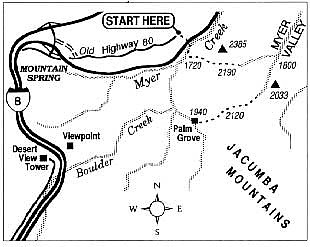
Have you ever driven down Interstate 8 east of Jacumba and, eyeing the immense boulder piles that rise on both sides, wondered what it would be like to clamber over them? Here's your chance. Follow these directions, and you'll be on your way into what is known as the Jacumba Wilderness. This rugged and picturesque high-desert area gets relatively few footprints from recreational hikers and quite a number of them from migrants heading north from Mexico. So -- a word to the wise -- it is better to travel in large groups. Also bear in mind that by May the desert heat may reach an oppressive level on some days.
Exit I-8 at Mountain Spring. At a point midway in the "island" between the eastbound and westbound lanes of the freeway, turn east on a rough dirt road. In 0.2 mile this road joins the abandoned concrete ribbon of old US Highway 80. Drive (or walk if the road is too rough) east for an additional 1.3 miles and park near the road's end -- just before the brink of a road cut made for the eastbound lanes of I-8. What lies ahead is a 4-mile loop hike, or a shorter or longer reconnaissance of the area according to your taste. Knowledgeable hikers will want to have a copy of the US Geological Survey 7.5-minute In-Ko-Pah Gorge topographic map with them.
Scramble down the slope about 100 feet to the sandy bed of Myer Creek. Pass under the lanes of I-8 through the large culvert to the west and continue 0.1 mile in the wash until you come to the base of a rocky gully on the left (east). Scramble up the coarse-grained granitic boulders in this gully; after 400 feet of elevation gain you join a sandy wash. Continue east, passing over a saddle and then on down into Myer Valley. The half-square-mile valley, thickly grown with creosote-bush and ocotillo, sheds water to the north. A maze of disused jeep roads (closed to vehicle traffic even before this area was declared a Bureau of Land Management wilderness) laces the valley.
Upon reaching the edge of the valley, you can turn south and skirt the west edge of the valley, following a minor wash. Pick up traces of an old jeep trail about 0.3 mile southwest of a peak labeled elevation 2033 on the topographic map. Follow this west-southwest to the top of a broad divide and then descend toward a ravine that leads west into a north-flowing tributary of Boulder Creek. After some moderate scrambling, you'll arrive at a beautiful palm oasis, complete with a year-round spring. A dry fall (perhaps streaked with moisture if rains have come) and some Indian grinding holes are nearby.
From the palm oasis, it's an easy 1.2 miles back to the culvert under I-8, via Boulder and Myer creeks -- downhill in wash bottoms all the way.
Here's something you might be interested in.
Surreal landscapes of stacked boulders amaze hikers on a trek through Myer Valley near Jacumba.
Surreal landscapes of stacked boulders amaze hikers on a trek through Myer Valley near Jacumba.
Have you ever driven down Interstate 8 east of Jacumba and, eyeing the immense boulder piles that rise on both sides, wondered what it would be like to clamber over them? Here's your chance. Follow these directions, and you'll be on your way into what is known as the Jacumba Wilderness. This rugged and picturesque high-desert area gets relatively few footprints from recreational hikers and quite a number of them from migrants heading north from Mexico. So -- a word to the wise -- it is better to travel in large groups. Also bear in mind that by May the desert heat may reach an oppressive level on some days.
Exit I-8 at Mountain Spring. At a point midway in the "island" between the eastbound and westbound lanes of the freeway, turn east on a rough dirt road. In 0.2 mile this road joins the abandoned concrete ribbon of old US Highway 80. Drive (or walk if the road is too rough) east for an additional 1.3 miles and park near the road's end -- just before the brink of a road cut made for the eastbound lanes of I-8. What lies ahead is a 4-mile loop hike, or a shorter or longer reconnaissance of the area according to your taste. Knowledgeable hikers will want to have a copy of the US Geological Survey 7.5-minute In-Ko-Pah Gorge topographic map with them.
Scramble down the slope about 100 feet to the sandy bed of Myer Creek. Pass under the lanes of I-8 through the large culvert to the west and continue 0.1 mile in the wash until you come to the base of a rocky gully on the left (east). Scramble up the coarse-grained granitic boulders in this gully; after 400 feet of elevation gain you join a sandy wash. Continue east, passing over a saddle and then on down into Myer Valley. The half-square-mile valley, thickly grown with creosote-bush and ocotillo, sheds water to the north. A maze of disused jeep roads (closed to vehicle traffic even before this area was declared a Bureau of Land Management wilderness) laces the valley.
Upon reaching the edge of the valley, you can turn south and skirt the west edge of the valley, following a minor wash. Pick up traces of an old jeep trail about 0.3 mile southwest of a peak labeled elevation 2033 on the topographic map. Follow this west-southwest to the top of a broad divide and then descend toward a ravine that leads west into a north-flowing tributary of Boulder Creek. After some moderate scrambling, you'll arrive at a beautiful palm oasis, complete with a year-round spring. A dry fall (perhaps streaked with moisture if rains have come) and some Indian grinding holes are nearby.
From the palm oasis, it's an easy 1.2 miles back to the culvert under I-8, via Boulder and Myer creeks -- downhill in wash bottoms all the way.