Here's something you might be interested in.
Ask a Hipster — Advice you didn't know you needed
Big Screen — Movie commentary
Blurt — Music's inside track
Booze News — San Diego spirits
Classical Music — Immortal beauty
Classifieds — Free and easy
Cover Stories — Front-page features
Drinks All Around — Bartenders' drink recipes
Excerpts — Literary and spiritual excerpts
Feast! — Food & drink reviews
Feature Stories — Local news & stories
Fishing Report — What’s getting hooked from ship and shore
From the Archives — Spotlight on the past
Golden Dreams — Talk of the town
The Gonzo Report — Making the musical scene, or at least reporting from it
Letters — Our inbox
Movies@Home — Local movie buffs share favorites
Movie Reviews — Our critics' picks and pans
Musician Interviews — Up close with local artists
Neighborhood News from Stringers — Hyperlocal news
News Ticker — News & politics
Obermeyer — San Diego politics illustrated
Outdoors — Weekly changes in flora and fauna
Overheard in San Diego — Eavesdropping illustrated
Poetry — The old and the new
Reader Travel — Travel section built by travelers
Reading — The hunt for intellectuals
Roam-O-Rama — SoCal's best hiking/biking trails
San Diego Beer — Inside San Diego suds
SD on the QT — Almost factual news
Sheep and Goats — Places of worship
Special Issues — The best of
Street Style — San Diego streets have style
Surf Diego — Real stories from those braving the waves
Theater — On stage in San Diego this week
Tin Fork — Silver spoon alternative
Under the Radar — Matt Potter's undercover work
Unforgettable — Long-ago San Diego
Unreal Estate — San Diego's priciest pads
Your Week — Daily event picks
Carrizo Gorge Overlook
Few travelers on Interstate 8 in eastern San Diego County fail to be impressed by the enormous stacks of rounded boulders thrusting skyward over the high-desert landscape.
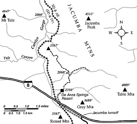
On this hike, you’ll get up-close and familiar with some of those big boulder piles and enjoy a panoramic view of a deep cleft called Carrizo Gorge. You start on private De Anza Springs resort property, so you might want to call the resort (619-766-4301) for planning purposes.
To get to the trailhead, exit Interstate 8 at the Jacumba exit. Turn sharply right (west, back toward San Diego) and follow a smoothly graded, unpaved frontage road two miles to the DeAnza Springs clothing-optional resort. At the entrance gate, use the intercom to ask permission to hike from the property into Anza-Borrego Desert State Park. Staff will likely direct you to park your car outside the resort’s office building, and go inside to register and pay a small fee.
You actually “hit the trail” at a marked trailhead on the northeast edge of the resort. That trail follows a sandy wash east for about 50 yards, then veers left, joining an old jeep road swinging north. You soon pass through a gap in a wire fence marking your transition between the resort property and lands inside Anza-Borrego Desert State Park.
What’s the deal with the boulders here? Just the result of weathering of a rising mass of granitic rock taking place underground and on the surface. Groundwater infiltrates the joints (cracks) in the rock mass before any overlying layers of rock or soil have eroded away. Gaps open up as the rock is subject to slow decomposition by physical forces and chemical processes. Further, the mineral grains on any sharp corner of a rock surface will tend to loosen and fall away easier, thus contributing to an overall rounding effect. The stacks of rounded boulders you see are like the tiniest tips of icebergs. They will “rot away” completely in the next few tens of thousands of years. Meanwhile, more rock will rise to replace them.
At 0.7 mile into the hike, the old road tops a rise and descends a little. Ahead you can see another old jeep road climbing eastward. This is not the route either out or back, so try to avoid straying onto this when you are returning later. (Yes, this is one area where a detailed topographic map or GPS unit is useful for navigation.)
You stay left on an obscure roadbed going northwest down to a sandy wash. Go east along the north bank of the wash for 50 yards, and then cut left to resume your travel northwest. Some juniper bushes and plenty of chaparral and desert shrubs grow among the giant stacks of boulders on both sides of the old road.
At 1.7 miles, the ascent, which has been gentle for the last mile, quickens. You zigzag up a dry, south-facing slope, maintaining the same general northwest direction. Continue over a rise at 2.0 miles, descend a bit, then climb steeply to the rounded top of a ridge (peak 3367). To get the best view, don’t stop here. Keep going 0.2 mile west along the ridge to its west shoulder, where a magnificent panorama opens of the entire middle section of Carrizo Gorge. As you look down upon the San Diego & Arizona Eastern tracks precariously threading the east side of the gorge, you’ll understand why the famed rail line has long been nicknamed the “Impossible Railroad.”
This article contains information about a publicly owned recreation or wilderness area. Trails and pathways are not necessarily marked. Conditions can change rapidly. Hikers should be properly equipped and have safety and navigational skills. The Reader and Jerry Schad assume no responsibility for any adverse experience.
Carrizo Gorge Overlook
Get an eagle’s eye view of rugged Carrizo Gorge, home of the “Impossible Railroad.”
Distance from downtown San Diego: 70 miles
Hiking length: 5.0 miles round trip
Difficulty: Moderate
Here's something you might be interested in.
Carrizo Gorge Overlook
Carrizo Gorge Overlook
Few travelers on Interstate 8 in eastern San Diego County fail to be impressed by the enormous stacks of rounded boulders thrusting skyward over the high-desert landscape.
On this hike, you’ll get up-close and familiar with some of those big boulder piles and enjoy a panoramic view of a deep cleft called Carrizo Gorge. You start on private De Anza Springs resort property, so you might want to call the resort (619-766-4301) for planning purposes.
To get to the trailhead, exit Interstate 8 at the Jacumba exit. Turn sharply right (west, back toward San Diego) and follow a smoothly graded, unpaved frontage road two miles to the DeAnza Springs clothing-optional resort. At the entrance gate, use the intercom to ask permission to hike from the property into Anza-Borrego Desert State Park. Staff will likely direct you to park your car outside the resort’s office building, and go inside to register and pay a small fee.
You actually “hit the trail” at a marked trailhead on the northeast edge of the resort. That trail follows a sandy wash east for about 50 yards, then veers left, joining an old jeep road swinging north. You soon pass through a gap in a wire fence marking your transition between the resort property and lands inside Anza-Borrego Desert State Park.
What’s the deal with the boulders here? Just the result of weathering of a rising mass of granitic rock taking place underground and on the surface. Groundwater infiltrates the joints (cracks) in the rock mass before any overlying layers of rock or soil have eroded away. Gaps open up as the rock is subject to slow decomposition by physical forces and chemical processes. Further, the mineral grains on any sharp corner of a rock surface will tend to loosen and fall away easier, thus contributing to an overall rounding effect. The stacks of rounded boulders you see are like the tiniest tips of icebergs. They will “rot away” completely in the next few tens of thousands of years. Meanwhile, more rock will rise to replace them.
At 0.7 mile into the hike, the old road tops a rise and descends a little. Ahead you can see another old jeep road climbing eastward. This is not the route either out or back, so try to avoid straying onto this when you are returning later. (Yes, this is one area where a detailed topographic map or GPS unit is useful for navigation.)
You stay left on an obscure roadbed going northwest down to a sandy wash. Go east along the north bank of the wash for 50 yards, and then cut left to resume your travel northwest. Some juniper bushes and plenty of chaparral and desert shrubs grow among the giant stacks of boulders on both sides of the old road.
At 1.7 miles, the ascent, which has been gentle for the last mile, quickens. You zigzag up a dry, south-facing slope, maintaining the same general northwest direction. Continue over a rise at 2.0 miles, descend a bit, then climb steeply to the rounded top of a ridge (peak 3367). To get the best view, don’t stop here. Keep going 0.2 mile west along the ridge to its west shoulder, where a magnificent panorama opens of the entire middle section of Carrizo Gorge. As you look down upon the San Diego & Arizona Eastern tracks precariously threading the east side of the gorge, you’ll understand why the famed rail line has long been nicknamed the “Impossible Railroad.”
This article contains information about a publicly owned recreation or wilderness area. Trails and pathways are not necessarily marked. Conditions can change rapidly. Hikers should be properly equipped and have safety and navigational skills. The Reader and Jerry Schad assume no responsibility for any adverse experience.
Carrizo Gorge Overlook
Get an eagle’s eye view of rugged Carrizo Gorge, home of the “Impossible Railroad.”
Distance from downtown San Diego: 70 miles
Hiking length: 5.0 miles round trip
Difficulty: Moderate