Here's something you might be interested in.
Ask a Hipster — Advice you didn't know you needed
Big Screen — Movie commentary
Blurt — Music's inside track
Booze News — San Diego spirits
Classical Music — Immortal beauty
Classifieds — Free and easy
Cover Stories — Front-page features
Drinks All Around — Bartenders' drink recipes
Excerpts — Literary and spiritual excerpts
Feast! — Food & drink reviews
Feature Stories — Local news & stories
Fishing Report — What’s getting hooked from ship and shore
From the Archives — Spotlight on the past
Golden Dreams — Talk of the town
The Gonzo Report — Making the musical scene, or at least reporting from it
Letters — Our inbox
Movies@Home — Local movie buffs share favorites
Movie Reviews — Our critics' picks and pans
Musician Interviews — Up close with local artists
Neighborhood News from Stringers — Hyperlocal news
News Ticker — News & politics
Obermeyer — San Diego politics illustrated
Outdoors — Weekly changes in flora and fauna
Overheard in San Diego — Eavesdropping illustrated
Poetry — The old and the new
Reader Travel — Travel section built by travelers
Reading — The hunt for intellectuals
Roam-O-Rama — SoCal's best hiking/biking trails
San Diego Beer — Inside San Diego suds
SD on the QT — Almost factual news
Sheep and Goats — Places of worship
Special Issues — The best of
Street Style — San Diego streets have style
Surf Diego — Real stories from those braving the waves
Theater — On stage in San Diego this week
Tin Fork — Silver spoon alternative
Under the Radar — Matt Potter's undercover work
Unforgettable — Long-ago San Diego
Unreal Estate — San Diego's priciest pads
Your Week — Daily event picks
Enchanted by a ring of mountains
Discovering the center of the universe in the mountains of San Diego
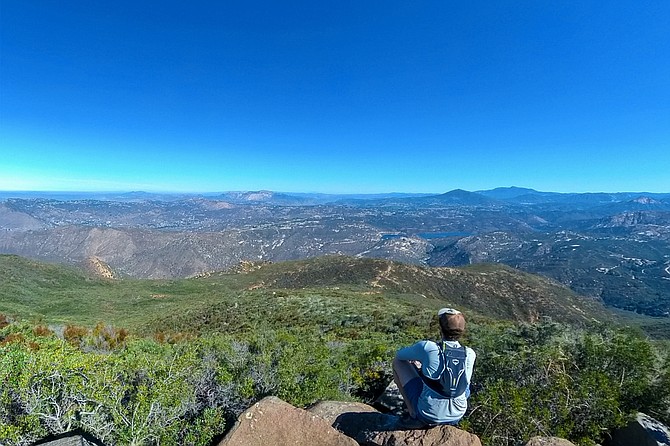
Me looking east.
- Located in Jamul, Sycuan Peak is a moderate hike. Given its length of around 2 miles and an elevation gain of 800 feet, the hike will take most people a little over an hour.
- Distance from downtown San Diego: 25 miles
- Hike length: 2.1 miles • Difficulty: Moderate • Season: October to April
Years ago, during a self-guided rafting expedition in Alaska, I found myself on a small island where four major valleys and two mighty rivers converged. Nestled on this island was a giant boulder adorned with a petroglyph that revealed itself when wet. The carving depicted a dot encircled by two concentric rings, with straight lines extending from the outer ring. The indigenous people referred to this confluence as "the center of the universe," and while standing on that boulder above the treeline, I had unknowingly stepped into a panorama where the grandeur of the mountains, glaciers, and the powerful rivers' merging forces enveloped me.
As I’ve explored the rolling hills and peaks of San Diego, I’ve frequently sought a similar place—a location where it felt as though all the mountains and valleys converged into one and flowed through me. Well, it turns out that I’ve been skirting around this vantage point for years. Like a blind man feeling his way along the walls of a room, stopping to feel every bit of decoration, so too did I ascend every peak while unwittingly orbiting this central point. Now, only after summiting Sycuan Peak on a whim, can I confidently say that I've discovered the peak I had been hopelessly searching for.
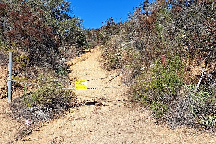
Trailhead
The hike up had been rather unremarkable. I parked along the side of Lawson Valley Road on a strip of dirt that could fit no more than six cars. But on this warm weekday morning, I was alone. The trailhead was marked by two metal posts connected by two steel chains with a sign that read, “boundary ecological reserve,” fastened between them. Beyond it, the trail twisted up a sharp slope that switched back on itself twice, between which was a steep climb up a wash. Just past this section, to the left, were two silver water tanks with an American flag waving between them. Upon passing them, I was greeted by an even steeper climb up a deeper wash, but the trail was wide and easy to read.
From here on, the trail became even less distinguishing. The air was arid, with the occasional breeze from the west. The earth took on an orange hue in certain areas, and traces of animal scat dotted the path. Countless chamise thrived along the edges of the trail, while small yellow-flowered broomweed and Russian thistle popped up here and there. Like many of the hikes in Jamul, the trail appeared as though it had once been a service road for vehicles but had since been reclaimed by nature's grasp and eroded by the steady drip of time. Overhead, in the deep blue sky, passing planes flew low and turned sharply to the west to begin their final descent into San Diego.
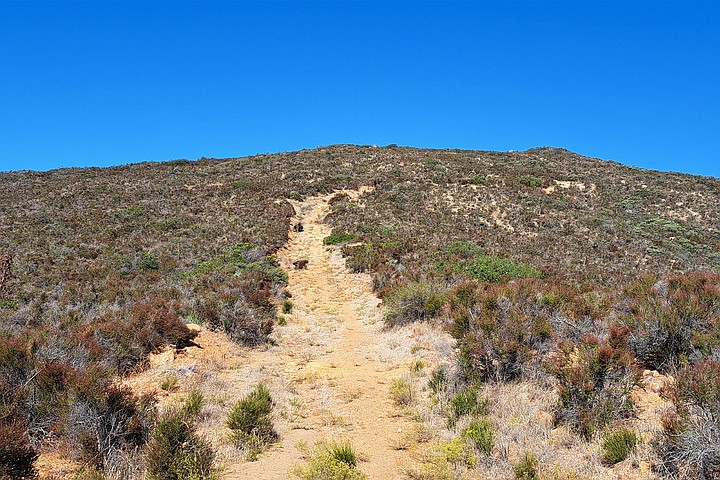
Trail ascending while near the top.
At one point, I turned around to look eastward and saw a grim scene. The trail I’d climbed up veered left, disappearing behind the vegetation, and it felt as if there was no indication of a mountain beneath me. Instead, it appeared as though I stood before the edge of a steep cliff. Had I moved closer to this ledge, I would have seen the mountain below, but from where I stood, it and the valley below were hidden. Although the sky remained a clear blue, the scene reminded me of a John Martin painting, with the distant valley seemingly tilting towards the heavens. Had the valley tilted any further, I would have thought the distant homes and dirt roads would have broken apart and slid into an unseen abyss; like scraps of food sliding off a plate and into the trash.
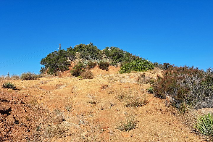
The summit
The top of the mountain was rough and unpolished. It looked less like a peak and more like a large mound covered in shrubs. In the center of these shrubs were small boulders covered in painted graffiti. On the other side of the mound, a lone wooden telephone pole stood erect. There was no breeze. The only sound was a loud buzzing as flies chased one another over the surrounding thicket like soldiers in a battlefield. There was nothing charming about the place. It was only when looking out onto the view that I found myself enchanted.
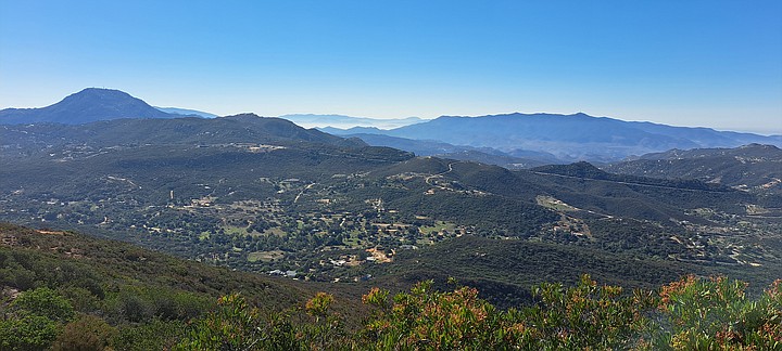
Looking south
A ring of mountains encircled me, beyond which lay another ring with distant peaks. These peaks had a familiar bearing, and as I regarded each one, many of them I recognized and spoke their names aloud. Like a long-awaited reunion between close friends, it dawned on me that I knew every one of these peaks. And even more astonishing, none were missing or obstructed.
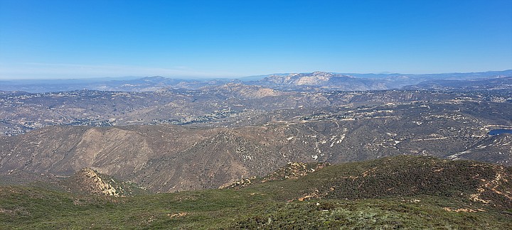
Looking north
To the north, I beheld the granite face of El Cajon Mountain, the sharp point of Iron Mountain, and the long ridge of Mt. Woodson with its antennas. To the east, more familiar faces rose up from the earth, but it was to the south that the closest face loomed, as Lyons Peak rose up, large and mighty with a crown of antennas. Further west stretched the full ridge of Otay Mountain towards Mexico, gradually vanishing into misty hills.
After greeting each mountain, I espied an unexpected guest far to the northeast. Just beyond the Palomar range was San Jacinto Peak, poking its head out like a whale surfacing from the sea with a friendly nod.
In retracing my steps down the mountain, I wondered whether I would have discovered this vantage point sooner had I invested more time studying maps. But as I followed the trail down, I remembered that the path unfolds only when we discern the subtle signs that guide our way. Had I climbed Sycuan sooner than its neighbors, I would not have recognized the peaks that embraced me. And instead of discovering the center of the universe in the mountains of San Diego, I would have felt caught between strangers.
Here's something you might be interested in.
Enchanted by a ring of mountains
Discovering the center of the universe in the mountains of San Diego
Enchanted by a ring of mountains
Discovering the center of the universe in the mountains of San Diego
Me looking east.
- Located in Jamul, Sycuan Peak is a moderate hike. Given its length of around 2 miles and an elevation gain of 800 feet, the hike will take most people a little over an hour.
- Distance from downtown San Diego: 25 miles
- Hike length: 2.1 miles • Difficulty: Moderate • Season: October to April
Years ago, during a self-guided rafting expedition in Alaska, I found myself on a small island where four major valleys and two mighty rivers converged. Nestled on this island was a giant boulder adorned with a petroglyph that revealed itself when wet. The carving depicted a dot encircled by two concentric rings, with straight lines extending from the outer ring. The indigenous people referred to this confluence as "the center of the universe," and while standing on that boulder above the treeline, I had unknowingly stepped into a panorama where the grandeur of the mountains, glaciers, and the powerful rivers' merging forces enveloped me.
As I’ve explored the rolling hills and peaks of San Diego, I’ve frequently sought a similar place—a location where it felt as though all the mountains and valleys converged into one and flowed through me. Well, it turns out that I’ve been skirting around this vantage point for years. Like a blind man feeling his way along the walls of a room, stopping to feel every bit of decoration, so too did I ascend every peak while unwittingly orbiting this central point. Now, only after summiting Sycuan Peak on a whim, can I confidently say that I've discovered the peak I had been hopelessly searching for.
Trailhead
The hike up had been rather unremarkable. I parked along the side of Lawson Valley Road on a strip of dirt that could fit no more than six cars. But on this warm weekday morning, I was alone. The trailhead was marked by two metal posts connected by two steel chains with a sign that read, “boundary ecological reserve,” fastened between them. Beyond it, the trail twisted up a sharp slope that switched back on itself twice, between which was a steep climb up a wash. Just past this section, to the left, were two silver water tanks with an American flag waving between them. Upon passing them, I was greeted by an even steeper climb up a deeper wash, but the trail was wide and easy to read.
From here on, the trail became even less distinguishing. The air was arid, with the occasional breeze from the west. The earth took on an orange hue in certain areas, and traces of animal scat dotted the path. Countless chamise thrived along the edges of the trail, while small yellow-flowered broomweed and Russian thistle popped up here and there. Like many of the hikes in Jamul, the trail appeared as though it had once been a service road for vehicles but had since been reclaimed by nature's grasp and eroded by the steady drip of time. Overhead, in the deep blue sky, passing planes flew low and turned sharply to the west to begin their final descent into San Diego.
Trail ascending while near the top.
At one point, I turned around to look eastward and saw a grim scene. The trail I’d climbed up veered left, disappearing behind the vegetation, and it felt as if there was no indication of a mountain beneath me. Instead, it appeared as though I stood before the edge of a steep cliff. Had I moved closer to this ledge, I would have seen the mountain below, but from where I stood, it and the valley below were hidden. Although the sky remained a clear blue, the scene reminded me of a John Martin painting, with the distant valley seemingly tilting towards the heavens. Had the valley tilted any further, I would have thought the distant homes and dirt roads would have broken apart and slid into an unseen abyss; like scraps of food sliding off a plate and into the trash.
The summit
The top of the mountain was rough and unpolished. It looked less like a peak and more like a large mound covered in shrubs. In the center of these shrubs were small boulders covered in painted graffiti. On the other side of the mound, a lone wooden telephone pole stood erect. There was no breeze. The only sound was a loud buzzing as flies chased one another over the surrounding thicket like soldiers in a battlefield. There was nothing charming about the place. It was only when looking out onto the view that I found myself enchanted.
Looking south
A ring of mountains encircled me, beyond which lay another ring with distant peaks. These peaks had a familiar bearing, and as I regarded each one, many of them I recognized and spoke their names aloud. Like a long-awaited reunion between close friends, it dawned on me that I knew every one of these peaks. And even more astonishing, none were missing or obstructed.
Looking north
To the north, I beheld the granite face of El Cajon Mountain, the sharp point of Iron Mountain, and the long ridge of Mt. Woodson with its antennas. To the east, more familiar faces rose up from the earth, but it was to the south that the closest face loomed, as Lyons Peak rose up, large and mighty with a crown of antennas. Further west stretched the full ridge of Otay Mountain towards Mexico, gradually vanishing into misty hills.
After greeting each mountain, I espied an unexpected guest far to the northeast. Just beyond the Palomar range was San Jacinto Peak, poking its head out like a whale surfacing from the sea with a friendly nod.
In retracing my steps down the mountain, I wondered whether I would have discovered this vantage point sooner had I invested more time studying maps. But as I followed the trail down, I remembered that the path unfolds only when we discern the subtle signs that guide our way. Had I climbed Sycuan sooner than its neighbors, I would not have recognized the peaks that embraced me. And instead of discovering the center of the universe in the mountains of San Diego, I would have felt caught between strangers.
Comments