Here's something you might be interested in.
Ask a Hipster — Advice you didn't know you needed
Big Screen — Movie commentary
Blurt — Music's inside track
Booze News — San Diego spirits
Classical Music — Immortal beauty
Classifieds — Free and easy
Cover Stories — Front-page features
Drinks All Around — Bartenders' drink recipes
Excerpts — Literary and spiritual excerpts
Feast! — Food & drink reviews
Feature Stories — Local news & stories
Fishing Report — What’s getting hooked from ship and shore
From the Archives — Spotlight on the past
Golden Dreams — Talk of the town
The Gonzo Report — Making the musical scene, or at least reporting from it
Letters — Our inbox
Movies@Home — Local movie buffs share favorites
Movie Reviews — Our critics' picks and pans
Musician Interviews — Up close with local artists
Neighborhood News from Stringers — Hyperlocal news
News Ticker — News & politics
Obermeyer — San Diego politics illustrated
Outdoors — Weekly changes in flora and fauna
Overheard in San Diego — Eavesdropping illustrated
Poetry — The old and the new
Reader Travel — Travel section built by travelers
Reading — The hunt for intellectuals
Roam-O-Rama — SoCal's best hiking/biking trails
San Diego Beer — Inside San Diego suds
SD on the QT — Almost factual news
Sheep and Goats — Places of worship
Special Issues — The best of
Street Style — San Diego streets have style
Surf Diego — Real stories from those braving the waves
Theater — On stage in San Diego this week
Tin Fork — Silver spoon alternative
Under the Radar — Matt Potter's undercover work
Unforgettable — Long-ago San Diego
Unreal Estate — San Diego's priciest pads
Your Week — Daily event picks
Vast views from Viejas Mountain
Viejas Mountain South Approach from Willows Road
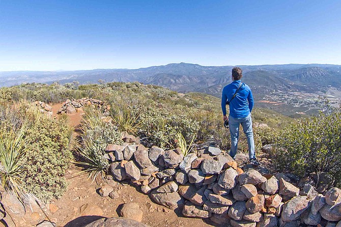
Standing on top of Viejas Mountain looking towards Cuyamaca Peak.
- Viejas Mountain
- Located in Alpine, Viejas Mountain is a challenging hike and long pants are recommended. With a length of 4.6 miles and an elevation gain of 2000+ feet, the hike will take most people between 2 and 4 hours to reach the summit and descend. Dogs are allowed, but not recommended for this approach.
- Distance from downtown San Diego: 32 miles
- Hike length: 4.6 miles • Difficulty: Strenuous • Season: October - April
I was stalling. I had driven out to the trailhead in Alpine and parked 10 minutes earlier, then set my watch to record my hike time and stretched my legs thoroughly. Now I was fumbling through my backpack for the third time, making sure my keys were still in the upper pocket (unfortunately, they were). I sighed anxiously, aware that I had run out of excuses, then closed my car door and crossed the lonely parking lot toward the trailhead. I had made the decision to hike up Viejas Mountain from the south approach, to test myself. Since the pandemic, I had grown accustomed to short comfortable hikes close to home and I wanted to see whether I still had my trail legs.

Looking up at the first climb from the trailhead.
As I reached the trailhead, I looked up at the side of the steep hill. Before me was a 2000’ climb over 2.3 miles. I felt daunted, not just from the steep incline, but from the fear that in these last couple of years, I had become a shadow of my former hiking self. I tried to reassure myself, but couldn’t find any comfort in my thoughts, so I took a breath and plunged onto the path.
The dirt was brownish-red and covered in loose rocks. Within a hundred paces the trail curved sharply upwards, and after a few minutes I was already breathing heavily. The warm air had found me and I could hear the whoosh of cars on the freeway behind me. As I pressed on, I began to feel myself slipping into what I call the void — a cozy silence in which my thoughts fade and my body flows along the earth.

Looking west from the peak.
An hour later, I was standing on the peak. Evidently my trail legs had returned, though my cap and shirt were damp with sweat from the effort. My lungs burned slightly and I rubbed the salt crystals from my eyelids as I looked around. The top was long and flat, and I was standing alone in between several rock windbreaks that had been assembled like the foundations of an old cabin. In the center of them, on a stone, were three metal tea canisters. Although they were dented and covered in stickers, the canisters softly shined in the late morning sun; I opened one to find a summit log containing scraps of paper. I fingered through them and pulled out a blue-tinted polaroid of a young couple. It showed them standing on the peak with weary smiles. I tucked it back in then read through a few of the notes. I won’t disclose what they said as it doesn’t seem proper, so you’ll just have to make the climb yourself if you’re curious.

Looking east from the peak.
With the canisters put away, I took in the panoramic display surrounding me. Viejas Mountain is perhaps as central a view as one can get of the inland peaks and distant mountains. To the north was the long, hunched ridge of the Palomar Mountain range, with San Gorgonio and San Jacinto lurking behind it. The low-slung top of Cuyamaca Peak squatted in the east, atop which I could see two vast radio towers. To the south, I had a rare view of Lawson and Gaskill Peaks, with Tecate Peak far away near the border. And to the west, I saw several familiar mountains, including El Cajon Mountain, Iron Mountain, Mount Woodson, and even Black Mountain and the five peaks of Mission Trails.
The sun watched me as I gazed at the mountains, and feeling its heat on my skin, I slung my pack on my shoulder and started back. The way down was much more enjoyable, as I stopped to identify plants and take photos. You see, there are two ways to journey along a trail. The first is to walk along it leisurely; stopping often to take in the rich sights and sounds surrounding you. On a very pleasant and solitary walk, you might even begin to hum absentmindedly while looking at a plant. The second way is to hike it. That is, to heave yourself along the trail, keeping your eyes just ahead of your boots as you try to keep a swift pace just short of fainting. The aim isn’t to race to the end, but to use your body with succinct precision, such that each step forward is one measured step closer to the goal. I myself prefer to hike uphill to satisfy my legs and then walk downhill to satisfy my curiosity. Thus, it was only in retracing my steps that I began to notice my surroundings.

An Instaworthy metal post with a sign that reads 4189 Elev. Viejas Mtn.
Starting from the peak, there were several markers to follow back down. The first was an Instaworthy metal post with a sign that read ‘4189 Elev. Viejas Mtn.’ It was bolted atop a large boulder, one of many that I had to scramble over and press against to keep on the trail. After a hundred or so paces, the path split, with the main path veering down to the west while the south path continued along the ridgeline. After following the latter for a while, the trail spilled down from the crest where I overlooked a gorgeous sea of silver-green chaparral that receded into a dark-green shadow. Further in the distance, the dark emerald hills behind Alpine seemed to rise and swell like ocean waves. The trail here was narrow and easy to follow, though I found it difficult to take my eyes off the view.
From there, the south approach alternated between steep slopes and gradual plateaus, almost like traveling along very tall and wide steps. The trail was easy to follow during the gradual portions, but for the steeper sections, it often splintered into two or three paths before reuniting further ahead. I never felt lost, but I often found myself cutting through agave and golden-floreted rabbitbrush to get back on the main path. One reliable marker for determining whether I was on the right track was to look for small, dried out stumps. These typically indicated where the brush had been cleared to build a path.

Looking down from the top of the first section.
Continuing down the hillside, I saw Viejas Casino to the east and the concrete artery of I-8 disappearing into the mountains. Along it, distant cars seemed to crawl like tiny ants. As I reached the final descent, the trail connected with a drainage for runoff water. The dirt was dry but erodingm and I trod carefully to keep from falling off the hillside. The section loses about 1000’ of elevation in a little under a mile and I found my knees beginning to ache slightly from the amount of bracing I had to do to keep my footing.
As I neared the bottom, the brush-and-dirt path faded into asphalt and I could hear the hiss of cars on the freeway again as I stepped over shreds of sun-worn trash. The return to civilization was jarring, like being roused from a dream; and I found myself not wanting to wake, but to drift off and return to the vast views atop Viejas Mountain.
Here's something you might be interested in.
Vast views from Viejas Mountain
Viejas Mountain South Approach from Willows Road
Vast views from Viejas Mountain
Viejas Mountain South Approach from Willows Road
Standing on top of Viejas Mountain looking towards Cuyamaca Peak.
- Viejas Mountain
- Located in Alpine, Viejas Mountain is a challenging hike and long pants are recommended. With a length of 4.6 miles and an elevation gain of 2000+ feet, the hike will take most people between 2 and 4 hours to reach the summit and descend. Dogs are allowed, but not recommended for this approach.
- Distance from downtown San Diego: 32 miles
- Hike length: 4.6 miles • Difficulty: Strenuous • Season: October - April
I was stalling. I had driven out to the trailhead in Alpine and parked 10 minutes earlier, then set my watch to record my hike time and stretched my legs thoroughly. Now I was fumbling through my backpack for the third time, making sure my keys were still in the upper pocket (unfortunately, they were). I sighed anxiously, aware that I had run out of excuses, then closed my car door and crossed the lonely parking lot toward the trailhead. I had made the decision to hike up Viejas Mountain from the south approach, to test myself. Since the pandemic, I had grown accustomed to short comfortable hikes close to home and I wanted to see whether I still had my trail legs.
Looking up at the first climb from the trailhead.
As I reached the trailhead, I looked up at the side of the steep hill. Before me was a 2000’ climb over 2.3 miles. I felt daunted, not just from the steep incline, but from the fear that in these last couple of years, I had become a shadow of my former hiking self. I tried to reassure myself, but couldn’t find any comfort in my thoughts, so I took a breath and plunged onto the path.
The dirt was brownish-red and covered in loose rocks. Within a hundred paces the trail curved sharply upwards, and after a few minutes I was already breathing heavily. The warm air had found me and I could hear the whoosh of cars on the freeway behind me. As I pressed on, I began to feel myself slipping into what I call the void — a cozy silence in which my thoughts fade and my body flows along the earth.
Looking west from the peak.
An hour later, I was standing on the peak. Evidently my trail legs had returned, though my cap and shirt were damp with sweat from the effort. My lungs burned slightly and I rubbed the salt crystals from my eyelids as I looked around. The top was long and flat, and I was standing alone in between several rock windbreaks that had been assembled like the foundations of an old cabin. In the center of them, on a stone, were three metal tea canisters. Although they were dented and covered in stickers, the canisters softly shined in the late morning sun; I opened one to find a summit log containing scraps of paper. I fingered through them and pulled out a blue-tinted polaroid of a young couple. It showed them standing on the peak with weary smiles. I tucked it back in then read through a few of the notes. I won’t disclose what they said as it doesn’t seem proper, so you’ll just have to make the climb yourself if you’re curious.
Looking east from the peak.
With the canisters put away, I took in the panoramic display surrounding me. Viejas Mountain is perhaps as central a view as one can get of the inland peaks and distant mountains. To the north was the long, hunched ridge of the Palomar Mountain range, with San Gorgonio and San Jacinto lurking behind it. The low-slung top of Cuyamaca Peak squatted in the east, atop which I could see two vast radio towers. To the south, I had a rare view of Lawson and Gaskill Peaks, with Tecate Peak far away near the border. And to the west, I saw several familiar mountains, including El Cajon Mountain, Iron Mountain, Mount Woodson, and even Black Mountain and the five peaks of Mission Trails.
The sun watched me as I gazed at the mountains, and feeling its heat on my skin, I slung my pack on my shoulder and started back. The way down was much more enjoyable, as I stopped to identify plants and take photos. You see, there are two ways to journey along a trail. The first is to walk along it leisurely; stopping often to take in the rich sights and sounds surrounding you. On a very pleasant and solitary walk, you might even begin to hum absentmindedly while looking at a plant. The second way is to hike it. That is, to heave yourself along the trail, keeping your eyes just ahead of your boots as you try to keep a swift pace just short of fainting. The aim isn’t to race to the end, but to use your body with succinct precision, such that each step forward is one measured step closer to the goal. I myself prefer to hike uphill to satisfy my legs and then walk downhill to satisfy my curiosity. Thus, it was only in retracing my steps that I began to notice my surroundings.
An Instaworthy metal post with a sign that reads 4189 Elev. Viejas Mtn.
Starting from the peak, there were several markers to follow back down. The first was an Instaworthy metal post with a sign that read ‘4189 Elev. Viejas Mtn.’ It was bolted atop a large boulder, one of many that I had to scramble over and press against to keep on the trail. After a hundred or so paces, the path split, with the main path veering down to the west while the south path continued along the ridgeline. After following the latter for a while, the trail spilled down from the crest where I overlooked a gorgeous sea of silver-green chaparral that receded into a dark-green shadow. Further in the distance, the dark emerald hills behind Alpine seemed to rise and swell like ocean waves. The trail here was narrow and easy to follow, though I found it difficult to take my eyes off the view.
From there, the south approach alternated between steep slopes and gradual plateaus, almost like traveling along very tall and wide steps. The trail was easy to follow during the gradual portions, but for the steeper sections, it often splintered into two or three paths before reuniting further ahead. I never felt lost, but I often found myself cutting through agave and golden-floreted rabbitbrush to get back on the main path. One reliable marker for determining whether I was on the right track was to look for small, dried out stumps. These typically indicated where the brush had been cleared to build a path.
Looking down from the top of the first section.
Continuing down the hillside, I saw Viejas Casino to the east and the concrete artery of I-8 disappearing into the mountains. Along it, distant cars seemed to crawl like tiny ants. As I reached the final descent, the trail connected with a drainage for runoff water. The dirt was dry but erodingm and I trod carefully to keep from falling off the hillside. The section loses about 1000’ of elevation in a little under a mile and I found my knees beginning to ache slightly from the amount of bracing I had to do to keep my footing.
As I neared the bottom, the brush-and-dirt path faded into asphalt and I could hear the hiss of cars on the freeway again as I stepped over shreds of sun-worn trash. The return to civilization was jarring, like being roused from a dream; and I found myself not wanting to wake, but to drift off and return to the vast views atop Viejas Mountain.
Comments