Here's something you might be interested in.
Ask a Hipster — Advice you didn't know you needed
Big Screen — Movie commentary
Blurt — Music's inside track
Booze News — San Diego spirits
Classical Music — Immortal beauty
Classifieds — Free and easy
Cover Stories — Front-page features
Drinks All Around — Bartenders' drink recipes
Excerpts — Literary and spiritual excerpts
Feast! — Food & drink reviews
Feature Stories — Local news & stories
Fishing Report — What’s getting hooked from ship and shore
From the Archives — Spotlight on the past
Golden Dreams — Talk of the town
The Gonzo Report — Making the musical scene, or at least reporting from it
Letters — Our inbox
Movies@Home — Local movie buffs share favorites
Movie Reviews — Our critics' picks and pans
Musician Interviews — Up close with local artists
Neighborhood News from Stringers — Hyperlocal news
News Ticker — News & politics
Obermeyer — San Diego politics illustrated
Outdoors — Weekly changes in flora and fauna
Overheard in San Diego — Eavesdropping illustrated
Poetry — The old and the new
Reader Travel — Travel section built by travelers
Reading — The hunt for intellectuals
Roam-O-Rama — SoCal's best hiking/biking trails
San Diego Beer — Inside San Diego suds
SD on the QT — Almost factual news
Sheep and Goats — Places of worship
Special Issues — The best of
Street Style — San Diego streets have style
Surf Diego — Real stories from those braving the waves
Theater — On stage in San Diego this week
Tin Fork — Silver spoon alternative
Under the Radar — Matt Potter's undercover work
Unforgettable — Long-ago San Diego
Unreal Estate — San Diego's priciest pads
Your Week — Daily event picks
A lesson in pine cones
San Jacinto Peak in neighbor Riverside County
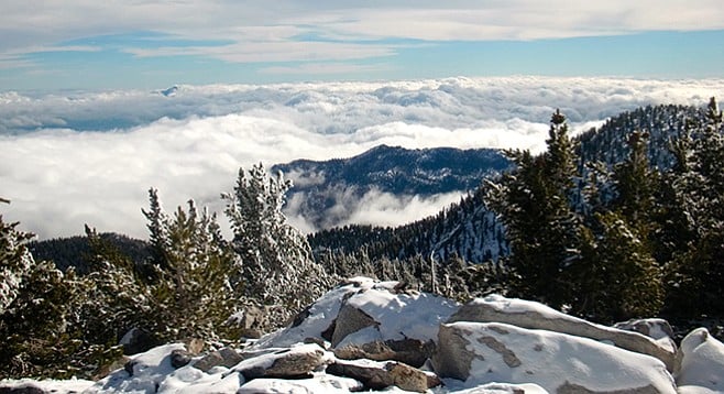
The view from San Jacinto Peak
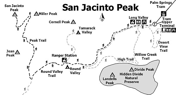
Mount San Jacinto State Park in neighboring Riverside County has plenty of hiking trails to satisfy those looking for a full-day adventure within a mountain setting. The hike to San Jacinto Summit (10,834 feet) is strenuous but stunning vistas and exposure to the unique mountain ecosystem can be enjoyed with less-challenging trails departing from the same trailhead (Desert View Trail, 1.5 miles round-trip, easy; Round Valley Trail, 4.0 miles round-trip with 600 feet elevation gain). Hiking within the park is enjoyable in any season. Mountain conditions can change rapidly, so check the weather.
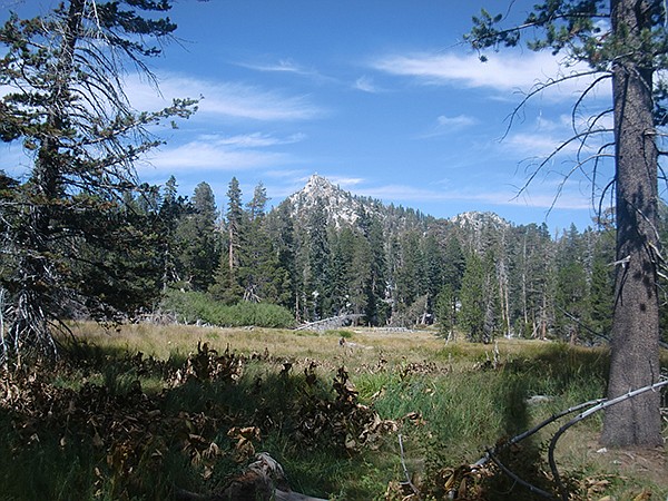
Round Valley in the fall
For maximum time to enjoy the high-country, park at the Palm Springs Aerial Tramway station. Fifteen minutes will carry you 2.5 miles and up 6000 feet. Be prepared to pay for round-trip tickets ($26), and, if not planning to arrive in time to take the first tram up the mountain (10 a.m. weekdays, 8 a.m. weekends), you will likely spend some time waiting for the next available tram. After leaving the tram station, fill out a day-use wilderness permit at the Long Valley Ranger Station, about a ten-minute walk from the tram station.
Fill out a day-use wilderness permit at the Long Valley Ranger Station.
From the Long Valley Ranger Station, hike two miles to Round Valley. Look for the easily identified, large bodied and blue Steller’s Jays (Cyanocitta stelleri). You will likely see them year-round. Along the way, notice the tall Jeffrey (Pinus jeffreyi) and ponderosa (Pinus ponderosa) pines. Both species have leaves in bundles of three. Jeffrey pine is often thought to smell like vanilla or butterscotch (smell within furrows of the bark) and have less prickly pine cones than the ponderosa. Perhaps a more reliable identification method is by pine-cone size. If you observe pine cones mostly less than 4.5 inches in length under a tree, it is likely a ponderosa. Bigger pine cones indicate Jeffrey. You are unlikely to confuse Jeffrey or ponderosa pines with sugar pines (Pinus lambertiana), but if you encounter cones bigger than 12 inches, you have found one of the park’s sugar pines. Sugar pines have the largest cones of any conifer and have needles found in bunches of five.
Continuing past Round Valley, a steep, one-mile hike will lead you to Wellman Divide. With vistas of the Coachella Valley, this area provides a nice turn-around point if the high-elevation hiking is proving particularly challenging, conditions on the switchbacks are too poor to continue, or if there is concern about adequate daylight hours. Passing Wellman Divide, you will start to encounter bush chinquapin (Chrysolepis sempervirens), which becomes particularly abundant on the switchbacks. It is in the oak family and typically grows to a height of between three and six feet. In the fall, the spiny nuts are highly characteristic. Also notice how the underside of the oblong leaves are yellow — this is observable in all seasons, as the shrub is evergreen. A careful eye will also be able to identify lupines in this section of the trail. As with most legumes, the high-quality leaf tissue of this nitrogen-fixing plant makes lupine a particularly tasty treat for deer and other herbivores; look for signs of leaves and buds being eaten.
Once reaching the summit, enjoy the view! Also, be sure to try to identify several limber pines (Pinus flexilis). Limber pines typically occur at high elevations and are not found in San Diego County. As a white pine, leaves are in bundles of five and usually under four inches in length. A fun trick is to age the needles. The limber pine retains its needles for several years, and each year’s growth reflects the growing conditions during that year. Once you see a clear change in length between sections of needles, you are likely looking at needles produced in two separate years. Shorter needles produced during a year could be indicative of conditions such as drought, while longer needles would reflect less-stressful growing conditions. Limber pines generally shed needles after about six years. What are the oldest needles you can find? Counting years backward, which years seemed to have the best and worst growing conditions? The tram back to the Coachella Valley floor is reached by retracing your steps.
Distance from downtown San Diego: 141 miles (Palm Springs). Allow 2 hours and 10 minutes driving time. From SR-163N, merge onto I-15N, then take I-215N toward Riverside/San Bernardino. Exit onto CA-60E then onto I-10E. Merge onto CA-111 toward Palm Springs and turn right onto Tram Way. Hiking length: 12 miles round trip with options for shorter hikes.
Difficulty: Very difficult. 12 miles round trip with extreme elevation gain/loss of 2500 feet at high altitude (10,834 feet at the peak). Options for shorter, below-9500 altitude hikes are available. Check current tram information at: pstramway.com/.
No dogs. Facilities at trailhead/tram station.
Here's something you might be interested in.
A lesson in pine cones
San Jacinto Peak in neighbor Riverside County
A lesson in pine cones
San Jacinto Peak in neighbor Riverside County
The view from San Jacinto Peak
Mount San Jacinto State Park in neighboring Riverside County has plenty of hiking trails to satisfy those looking for a full-day adventure within a mountain setting. The hike to San Jacinto Summit (10,834 feet) is strenuous but stunning vistas and exposure to the unique mountain ecosystem can be enjoyed with less-challenging trails departing from the same trailhead (Desert View Trail, 1.5 miles round-trip, easy; Round Valley Trail, 4.0 miles round-trip with 600 feet elevation gain). Hiking within the park is enjoyable in any season. Mountain conditions can change rapidly, so check the weather.
Round Valley in the fall
For maximum time to enjoy the high-country, park at the Palm Springs Aerial Tramway station. Fifteen minutes will carry you 2.5 miles and up 6000 feet. Be prepared to pay for round-trip tickets ($26), and, if not planning to arrive in time to take the first tram up the mountain (10 a.m. weekdays, 8 a.m. weekends), you will likely spend some time waiting for the next available tram. After leaving the tram station, fill out a day-use wilderness permit at the Long Valley Ranger Station, about a ten-minute walk from the tram station.
Fill out a day-use wilderness permit at the Long Valley Ranger Station.
From the Long Valley Ranger Station, hike two miles to Round Valley. Look for the easily identified, large bodied and blue Steller’s Jays (Cyanocitta stelleri). You will likely see them year-round. Along the way, notice the tall Jeffrey (Pinus jeffreyi) and ponderosa (Pinus ponderosa) pines. Both species have leaves in bundles of three. Jeffrey pine is often thought to smell like vanilla or butterscotch (smell within furrows of the bark) and have less prickly pine cones than the ponderosa. Perhaps a more reliable identification method is by pine-cone size. If you observe pine cones mostly less than 4.5 inches in length under a tree, it is likely a ponderosa. Bigger pine cones indicate Jeffrey. You are unlikely to confuse Jeffrey or ponderosa pines with sugar pines (Pinus lambertiana), but if you encounter cones bigger than 12 inches, you have found one of the park’s sugar pines. Sugar pines have the largest cones of any conifer and have needles found in bunches of five.
Continuing past Round Valley, a steep, one-mile hike will lead you to Wellman Divide. With vistas of the Coachella Valley, this area provides a nice turn-around point if the high-elevation hiking is proving particularly challenging, conditions on the switchbacks are too poor to continue, or if there is concern about adequate daylight hours. Passing Wellman Divide, you will start to encounter bush chinquapin (Chrysolepis sempervirens), which becomes particularly abundant on the switchbacks. It is in the oak family and typically grows to a height of between three and six feet. In the fall, the spiny nuts are highly characteristic. Also notice how the underside of the oblong leaves are yellow — this is observable in all seasons, as the shrub is evergreen. A careful eye will also be able to identify lupines in this section of the trail. As with most legumes, the high-quality leaf tissue of this nitrogen-fixing plant makes lupine a particularly tasty treat for deer and other herbivores; look for signs of leaves and buds being eaten.
Once reaching the summit, enjoy the view! Also, be sure to try to identify several limber pines (Pinus flexilis). Limber pines typically occur at high elevations and are not found in San Diego County. As a white pine, leaves are in bundles of five and usually under four inches in length. A fun trick is to age the needles. The limber pine retains its needles for several years, and each year’s growth reflects the growing conditions during that year. Once you see a clear change in length between sections of needles, you are likely looking at needles produced in two separate years. Shorter needles produced during a year could be indicative of conditions such as drought, while longer needles would reflect less-stressful growing conditions. Limber pines generally shed needles after about six years. What are the oldest needles you can find? Counting years backward, which years seemed to have the best and worst growing conditions? The tram back to the Coachella Valley floor is reached by retracing your steps.
Distance from downtown San Diego: 141 miles (Palm Springs). Allow 2 hours and 10 minutes driving time. From SR-163N, merge onto I-15N, then take I-215N toward Riverside/San Bernardino. Exit onto CA-60E then onto I-10E. Merge onto CA-111 toward Palm Springs and turn right onto Tram Way. Hiking length: 12 miles round trip with options for shorter hikes.
Difficulty: Very difficult. 12 miles round trip with extreme elevation gain/loss of 2500 feet at high altitude (10,834 feet at the peak). Options for shorter, below-9500 altitude hikes are available. Check current tram information at: pstramway.com/.
No dogs. Facilities at trailhead/tram station.
Comments