 another. In tracking, those are good signs.)
Here's something you might be interested in.
Ask a Hipster — Advice you didn't know you needed
Big Screen — Movie commentary
Blurt — Music's inside track
Booze News — San Diego spirits
Classical Music — Immortal beauty
Classifieds — Free and easy
Cover Stories — Front-page features
Drinks All Around — Bartenders' drink recipes
Excerpts — Literary and spiritual excerpts
Feast! — Food & drink reviews
Feature Stories — Local news & stories
Fishing Report — What’s getting hooked from ship and shore
From the Archives — Spotlight on the past
Golden Dreams — Talk of the town
The Gonzo Report — Making the musical scene, or at least reporting from it
Letters — Our inbox
Movies@Home — Local movie buffs share favorites
Movie Reviews — Our critics' picks and pans
Musician Interviews — Up close with local artists
Neighborhood News from Stringers — Hyperlocal news
News Ticker — News & politics
Obermeyer — San Diego politics illustrated
Outdoors — Weekly changes in flora and fauna
Overheard in San Diego — Eavesdropping illustrated
Poetry — The old and the new
Reader Travel — Travel section built by travelers
Reading — The hunt for intellectuals
Roam-O-Rama — SoCal's best hiking/biking trails
San Diego Beer — Inside San Diego suds
SD on the QT — Almost factual news
Sheep and Goats — Places of worship
Special Issues — The best of
Street Style — San Diego streets have style
Surf Diego — Real stories from those braving the waves
Theater — On stage in San Diego this week
Tin Fork — Silver spoon alternative
Under the Radar — Matt Potter's undercover work
Unforgettable — Long-ago San Diego
Unreal Estate — San Diego's priciest pads
Your Week — Daily event picks
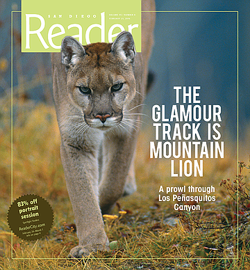
A prowl through Los Peñasquitos Canyon
The glamour track is mountain lion
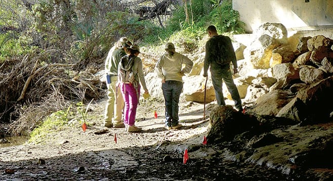
Volunteer tracking training under the bridge
Here kitty, kitty
We’re squatting in the mud in a culvert under Black Mountain Road, just east of Los Peñasquitos Canyon Preserve.
Even in the shade provided by the four-lane concrete-slab bridge, it’s 90 degrees. We’ve come out in a heat wave to learn how to look for evidence of animals in the dirt and help collect data for countywide wildlife surveys. We’re in the right place. Paw prints crisscross the spongy bank of the flowing creek, a popular watering hole in these drought conditions. Presence of water and adjacency to the preserve make this wildlife crossing a fitting classroom for the San Diego Tracking Team.
While kids played Saturday-morning soccer in the park fields, we practiced looking for signs of the animals that come out at dusk and dawn to make their living near the preserve. At first glance we recognized the heart-shaped prints of mule deer, the sole type of deer in San Diego. There’s plenty of domestic dog, of course — instructors alerted us to the distinctions between our faithful companions and other canines, like coyote. A dog track typically shows all four claws, while a coyote track usually registers only the inner two. Coyote tracks tend to be more oval, while dog prints are more circular (but can be slightly oval). To conserve energy coyotes walk a more direct path than pet dogs, which of course enjoy sniffing and exploring in all directions.
With all tracks, there is a variation in what registers — not every print is perfectly complete. Type and condition of substrate determine how much of an impression an animal will leave. Mud makes for good tracks, while hard dirt, pebbles, and vegetation obscure the evidence. Sometimes just a toe will show. Scat (a.k.a. poop) can be a more reliable sign of an animal’s presence — it stays behind. Our teachers promised we would learn more about scat in the advanced classes.
“The glamour track is mountain lion,” said team president Denise Harter, who started tracking in 2006 when her daughter began to show an interest in “mythical beasts.” To redirect her energies, Harter signed up for animal tracking. Though the mountain lion can be almost as elusive as a unicorn, the cat does still prowl in San Diego County. Their numbers are estimated at 4000 to 6000 in the state of California.
“Some of us think it is very cool to find ringtail or badger signs, because neither of them are very common here,“ Harter added. She told us about the last badger known to inhabit the area near Sorrento Valley Road, who met his fate shortly after an extension to the road was completed in the early 2000s. The badger, though notoriously tough, was no match for cars in his territory.
Harter was lucky enough to spot ringtail tracks on a special survey project in Carlsbad. Ringtails, which are also known as ring-tailed cats though they’re not feline, are members of the raccoon family. California has three sub-species, including the San Diego ringtail. They usually live in rocky, mountainous areas near water sources, but the tracks Harter saw were in a suburban neighborhood. She surmises the animal might have relocated due to stressors such as drought or fire, or someone might have been keeping it as a pet (illegally).
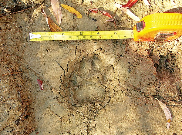
We didn’t see any mountain lion or ringtail tracks (or scat) under Black Mountain Road, but we were surprised and delighted when our teacher, Bob, set up a lesson for us to identify the tracks of what turned out to be a bobcat, Felis rufus. The bobcat tracks we saw were like a house cat’s but larger.
It’s estimated that there are 4000 to 6000 mountain lions roaming California.
Feline tracks are rounder than canine. Feline claws can partially or fully retract, but canine claws do not retract. Claw marks usually indicate canine — but claws can show if a cat is climbing or slipping. Another indicator trackers use when they’re kneeling in the dirt is to see if they can draw an imaginary X on the print without crossing the heel pad. An X marks a canine spot.
Enthused by the bobcat finding, we got to work on another set of prints a few feet away. We drew an X and found that it crossed over the heel pad; not canine, so possibly feline. The shape of the heel pad looked almost identical to the bobcat, a bit smaller but similar in size. We were ready to declare it Felis rufus.
Bobcat track
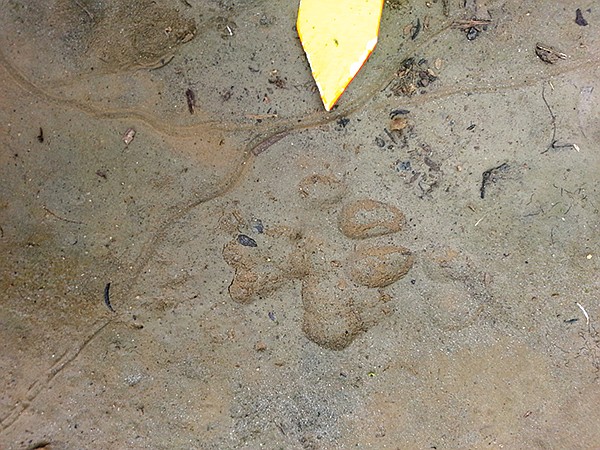
“I’m not sure if I would agree with that. Take a good look at the toes,” Bob said.
“See how that toe is set back, and it tapers at the top?” We were skeptical. We were hoping it was another bobcat, maybe a juvenile.
“Okay, I’ll give it away,” he conceded. “I know it looks a lot like bobcat, but it’s actually raccoon—otherwise known as ‘fake bobcat.’” Bob consoled us with the fact that even seasoned trackers mistake it. We were disappointed, but the experience reminded us to set aside our expectations and take a closer look.
The most unexpected animal evidence we encountered under the bridge was something neither canine nor feline nor rodent. Toward the end of class, the teacher pointed our attention to little holes lining the banks of the creek. There were dozens.
“What do you think could’ve made those holes?” Bob asked, chuckling to himself. We pondered what might’ve burrowed in.
“Spiders?” I thought of tarantulas.
“Wood rats?” We had learned about the diminutive rodents in class and seen some dainty prints that might belong to one.
“Something that raccoons really like to eat,” Bob gave us a clue. We ventured a few more incorrect guesses.
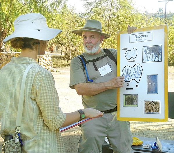
Tracking class instructor, Bob, shows how to identify raccoon tracks.
“No, no,” Bob laughed as he revealed the identity of the mysterious hole-maker. “It’s crayfish!” We laughed, too, at the presence of crustaceans down there, but it made sense why there were so many different kinds of tracks by the water: that spot is popular not only for the drinks but for the snacks. Raccoons go there for the seafood. Voles and rats go for the scraps, and bobcats go for the voles and rats.

Bobcat
The San Diego Tracking Team began its efforts as Friends of Los Peñasquitos Canyon in the late 1980s, partnering with the San Diego Biodiversity Project. Together they convinced the City of San Diego and Caltrans, among other agencies, of the importance of including wildlife corridors in urbanization plans. A “wildlife corridor” is a link or narrow area of native vegetation that joins larger areas of habitat between developed lands. Links between habitats are crucial to maintaining healthy viable populations of species.
Over the years, several San Diego County tracking teams merged into one umbrella group, while volunteers have been continuously compiling data since 1996. The database on the California Department of Fish and Wildlife website is available to the public. Collaborators such as San Diego State University, the United States Geological Society, and the Center for Natural Land Management use and analyze the data.
The team monitors the county by choosing 60 one-kilometer trail sections, called transects, with regular monitoring of each. From Anza-Borrego Desert State Park, where Harter saw a bighorn sheep nursing a baby, to urban areas like Rose Canyon near University City, volunteers walk “one usually hot and dusty trail (and muddy underpass and dark tunnel or sandy wash) at a time and compile data one track and one scat at a time.” Senior trackers must have at least five years of dirt time before “holding the clipboard” on surveys.
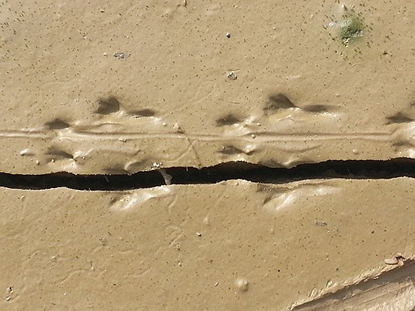
Kangaroo rat tracks
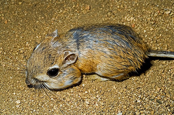
Kangaroo rat
During the surveys, volunteers look for signs of animals on the trail (going off-trail is a no-no) and the leader records findings on a chart. Apex predators bobcat, coyote, gray fox, kit fox, and mountain lion are all on the list. The team also keeps track of opossum, raccoon, striped skunk, spotted skunk, mule deer, wood rat, badger, bighorn sheep, black bear (rare in San Diego), black-tailed jackrabbit, burrowing owl, long-tailed weasel, ringtail, roadrunner, and kangaroo rat. Nests, burrows, scat, nibbled vegetation, dig marks, dust baths, fur and feathers, and caches of prey are all signs that animals have visited a spot.
“The rigor of our training program is one of the reasons our data is so sound, which in turn is largely responsible for our good reputation in the local conservation community,” Harter said. With the exception of a paid part-time administrative assistant and a data-entry person, members of the tracking team donate their time.
Tracking-team volunteers meet for citizen science training at Los Peñasquitos Adobe Ranch House, built by Capt. George Alonzo Johnson in 1861. The house was an expansion of earlier adobes built on the property by Capt. Francisco María Ruiz, who also constructed the first house in Old Town. In 1823, Ruiz received 4000 acres at Los Peñasquitos: the first land grant in San Diego under the Mexican government. It’s ironic that the place where development of the area began is now a place where people meet to learn how to help monitor human encroachment on animal habitat.
Eleven people showed up for the free class, including two children. When we introduced ourselves, one of the kids said he was there with his mom to do something besides play video games. He lost interest shortly after we got down in the mud and stood on the sidelines sullenly until his mom took him home. There was a ranger from Black Mountain Open Space Park, and a graduate student who studied waterfowl at UC Davis. Right up her alley: we found egret tracks among the many others under the bridge. A big and tall guy who rode in on a motorcycle started out with enthusiasm, but it looked like the heat got to him. Sweating profusely, he headed out early.
Photographs on the walls of the cozy ranch house conference room, where we gathered before heading out to the field, showed ladies of the family in long gingham and damask dresses, squinting into the sun. Over 100 years ago they lived on the ranch with horses, goats, cows, and chickens — probably worrying about losing livestock to the very predators the tracking team hopes to find in its surveys.
Kept by volunteers for nostalgia’s sake, domestic goats and chickens still call the preserve home. But now cows do. In 1989 cowboys staged a final cattle roundup: the legacy of roaming herds left from when George Sawday and Oliver Sexon, two of San Diego’s best-known cattlemen, bought the ranch in 1921. While we were in class a docent walked by dressed in heavy turn-of-the-century costume, despite the baking temperatures, on her way to give a tour of the adobe. Also on the grounds is the stone Springhouse, built over an artesian spring. Spanish missionaries watered their vineyards from the well, and later the road to Yuma ran through Los Peñasquitos, providing a watering stop for horses and horseless carriages alike. The same groundwater made this land a significant resource for the Kumeyaay for at least 12,000 years prior.
Los Peñasquitos Canyon Preserve links Carmel Mountain, Del Mar Mesa, and Black Mountain open-space preserves. Adjacent lands are owned by the California Department of Fish and Game and the U.S. Fish and Wildlife Service. Harter pointed out that from where we stood, near Black Mountain Road, open space runs contiguous to the coast ten miles west. It’s rare to find such corridors of undeveloped land — thus, Peñasquitos preserve sees many types of wildlife cross en route to eastern mountains or western wetlands. Indeed, the crossing makes a convenient, and historic corridor — in 1846 Kit Carson traversed the canyon and waded through the creek on his way to San Diego to secure reinforcements in the Battle of San Pasqual.
Concrete evidence of the tracking team’s efforts shows in the lack of concrete in other areas around San Diego. Available data helped make the case to keep recent expansion of State Route 56 out of Deer Canyon, preserving what Harter said is “San Diego County’s last coastal canyon.” Wildlife corridors have been maintained in multiple development projects, including the I-5/I-805 merge, Sorrento Valley Road and Carmel Valley Creek, and Rhodes Crossing (near Camino del Sur and Carmel Mountain Road). The team also contributes to studies of wildlife tunnel design, making sure that existing tunnels are large enough and that future projects plan for proper size and shape for animals to use crossings as intended.
Among its accomplishments, the team also counts the relocation of a hydroelectric pumping station that was slated for a narrow wildlife crossing behind Ridgewood Park in Rancho Peñasquitos in 2002. Armed with tracking-survey data from an adjacent transect, neighbors convinced planners to move the pump, which is 30 feet high, 70 feet wide, and 110 feet long, to an already developed commercial area just southwest of Interstate 15.
Harter spent December 2015 working with the U.S. Geological Survey to upload historical data to geographic information systems maps and deploying and monitoring wildlife cameras. A coyote mauled one of the cameras, and a bobcat marked (that’s right — urinated on) another. In tracking, those are good signs.
Here's something you might be interested in.
A prowl through Los Peñasquitos Canyon
The glamour track is mountain lion
A prowl through Los Peñasquitos Canyon
The glamour track is mountain lion
Volunteer tracking training under the bridge
Here kitty, kitty
We’re squatting in the mud in a culvert under Black Mountain Road, just east of Los Peñasquitos Canyon Preserve.
Even in the shade provided by the four-lane concrete-slab bridge, it’s 90 degrees. We’ve come out in a heat wave to learn how to look for evidence of animals in the dirt and help collect data for countywide wildlife surveys. We’re in the right place. Paw prints crisscross the spongy bank of the flowing creek, a popular watering hole in these drought conditions. Presence of water and adjacency to the preserve make this wildlife crossing a fitting classroom for the San Diego Tracking Team.
While kids played Saturday-morning soccer in the park fields, we practiced looking for signs of the animals that come out at dusk and dawn to make their living near the preserve. At first glance we recognized the heart-shaped prints of mule deer, the sole type of deer in San Diego. There’s plenty of domestic dog, of course — instructors alerted us to the distinctions between our faithful companions and other canines, like coyote. A dog track typically shows all four claws, while a coyote track usually registers only the inner two. Coyote tracks tend to be more oval, while dog prints are more circular (but can be slightly oval). To conserve energy coyotes walk a more direct path than pet dogs, which of course enjoy sniffing and exploring in all directions.
With all tracks, there is a variation in what registers — not every print is perfectly complete. Type and condition of substrate determine how much of an impression an animal will leave. Mud makes for good tracks, while hard dirt, pebbles, and vegetation obscure the evidence. Sometimes just a toe will show. Scat (a.k.a. poop) can be a more reliable sign of an animal’s presence — it stays behind. Our teachers promised we would learn more about scat in the advanced classes.
“The glamour track is mountain lion,” said team president Denise Harter, who started tracking in 2006 when her daughter began to show an interest in “mythical beasts.” To redirect her energies, Harter signed up for animal tracking. Though the mountain lion can be almost as elusive as a unicorn, the cat does still prowl in San Diego County. Their numbers are estimated at 4000 to 6000 in the state of California.
“Some of us think it is very cool to find ringtail or badger signs, because neither of them are very common here,“ Harter added. She told us about the last badger known to inhabit the area near Sorrento Valley Road, who met his fate shortly after an extension to the road was completed in the early 2000s. The badger, though notoriously tough, was no match for cars in his territory.
Harter was lucky enough to spot ringtail tracks on a special survey project in Carlsbad. Ringtails, which are also known as ring-tailed cats though they’re not feline, are members of the raccoon family. California has three sub-species, including the San Diego ringtail. They usually live in rocky, mountainous areas near water sources, but the tracks Harter saw were in a suburban neighborhood. She surmises the animal might have relocated due to stressors such as drought or fire, or someone might have been keeping it as a pet (illegally).
We didn’t see any mountain lion or ringtail tracks (or scat) under Black Mountain Road, but we were surprised and delighted when our teacher, Bob, set up a lesson for us to identify the tracks of what turned out to be a bobcat, Felis rufus. The bobcat tracks we saw were like a house cat’s but larger.
It’s estimated that there are 4000 to 6000 mountain lions roaming California.
Feline tracks are rounder than canine. Feline claws can partially or fully retract, but canine claws do not retract. Claw marks usually indicate canine — but claws can show if a cat is climbing or slipping. Another indicator trackers use when they’re kneeling in the dirt is to see if they can draw an imaginary X on the print without crossing the heel pad. An X marks a canine spot.
Enthused by the bobcat finding, we got to work on another set of prints a few feet away. We drew an X and found that it crossed over the heel pad; not canine, so possibly feline. The shape of the heel pad looked almost identical to the bobcat, a bit smaller but similar in size. We were ready to declare it Felis rufus.
Bobcat track
“I’m not sure if I would agree with that. Take a good look at the toes,” Bob said.
“See how that toe is set back, and it tapers at the top?” We were skeptical. We were hoping it was another bobcat, maybe a juvenile.
“Okay, I’ll give it away,” he conceded. “I know it looks a lot like bobcat, but it’s actually raccoon—otherwise known as ‘fake bobcat.’” Bob consoled us with the fact that even seasoned trackers mistake it. We were disappointed, but the experience reminded us to set aside our expectations and take a closer look.
The most unexpected animal evidence we encountered under the bridge was something neither canine nor feline nor rodent. Toward the end of class, the teacher pointed our attention to little holes lining the banks of the creek. There were dozens.
“What do you think could’ve made those holes?” Bob asked, chuckling to himself. We pondered what might’ve burrowed in.
“Spiders?” I thought of tarantulas.
“Wood rats?” We had learned about the diminutive rodents in class and seen some dainty prints that might belong to one.
“Something that raccoons really like to eat,” Bob gave us a clue. We ventured a few more incorrect guesses.
Tracking class instructor, Bob, shows how to identify raccoon tracks.
“No, no,” Bob laughed as he revealed the identity of the mysterious hole-maker. “It’s crayfish!” We laughed, too, at the presence of crustaceans down there, but it made sense why there were so many different kinds of tracks by the water: that spot is popular not only for the drinks but for the snacks. Raccoons go there for the seafood. Voles and rats go for the scraps, and bobcats go for the voles and rats.
Bobcat
The San Diego Tracking Team began its efforts as Friends of Los Peñasquitos Canyon in the late 1980s, partnering with the San Diego Biodiversity Project. Together they convinced the City of San Diego and Caltrans, among other agencies, of the importance of including wildlife corridors in urbanization plans. A “wildlife corridor” is a link or narrow area of native vegetation that joins larger areas of habitat between developed lands. Links between habitats are crucial to maintaining healthy viable populations of species.
Over the years, several San Diego County tracking teams merged into one umbrella group, while volunteers have been continuously compiling data since 1996. The database on the California Department of Fish and Wildlife website is available to the public. Collaborators such as San Diego State University, the United States Geological Society, and the Center for Natural Land Management use and analyze the data.
The team monitors the county by choosing 60 one-kilometer trail sections, called transects, with regular monitoring of each. From Anza-Borrego Desert State Park, where Harter saw a bighorn sheep nursing a baby, to urban areas like Rose Canyon near University City, volunteers walk “one usually hot and dusty trail (and muddy underpass and dark tunnel or sandy wash) at a time and compile data one track and one scat at a time.” Senior trackers must have at least five years of dirt time before “holding the clipboard” on surveys.
Kangaroo rat tracks
Kangaroo rat
During the surveys, volunteers look for signs of animals on the trail (going off-trail is a no-no) and the leader records findings on a chart. Apex predators bobcat, coyote, gray fox, kit fox, and mountain lion are all on the list. The team also keeps track of opossum, raccoon, striped skunk, spotted skunk, mule deer, wood rat, badger, bighorn sheep, black bear (rare in San Diego), black-tailed jackrabbit, burrowing owl, long-tailed weasel, ringtail, roadrunner, and kangaroo rat. Nests, burrows, scat, nibbled vegetation, dig marks, dust baths, fur and feathers, and caches of prey are all signs that animals have visited a spot.
“The rigor of our training program is one of the reasons our data is so sound, which in turn is largely responsible for our good reputation in the local conservation community,” Harter said. With the exception of a paid part-time administrative assistant and a data-entry person, members of the tracking team donate their time.
Tracking-team volunteers meet for citizen science training at Los Peñasquitos Adobe Ranch House, built by Capt. George Alonzo Johnson in 1861. The house was an expansion of earlier adobes built on the property by Capt. Francisco María Ruiz, who also constructed the first house in Old Town. In 1823, Ruiz received 4000 acres at Los Peñasquitos: the first land grant in San Diego under the Mexican government. It’s ironic that the place where development of the area began is now a place where people meet to learn how to help monitor human encroachment on animal habitat.
Eleven people showed up for the free class, including two children. When we introduced ourselves, one of the kids said he was there with his mom to do something besides play video games. He lost interest shortly after we got down in the mud and stood on the sidelines sullenly until his mom took him home. There was a ranger from Black Mountain Open Space Park, and a graduate student who studied waterfowl at UC Davis. Right up her alley: we found egret tracks among the many others under the bridge. A big and tall guy who rode in on a motorcycle started out with enthusiasm, but it looked like the heat got to him. Sweating profusely, he headed out early.
Photographs on the walls of the cozy ranch house conference room, where we gathered before heading out to the field, showed ladies of the family in long gingham and damask dresses, squinting into the sun. Over 100 years ago they lived on the ranch with horses, goats, cows, and chickens — probably worrying about losing livestock to the very predators the tracking team hopes to find in its surveys.
Kept by volunteers for nostalgia’s sake, domestic goats and chickens still call the preserve home. But now cows do. In 1989 cowboys staged a final cattle roundup: the legacy of roaming herds left from when George Sawday and Oliver Sexon, two of San Diego’s best-known cattlemen, bought the ranch in 1921. While we were in class a docent walked by dressed in heavy turn-of-the-century costume, despite the baking temperatures, on her way to give a tour of the adobe. Also on the grounds is the stone Springhouse, built over an artesian spring. Spanish missionaries watered their vineyards from the well, and later the road to Yuma ran through Los Peñasquitos, providing a watering stop for horses and horseless carriages alike. The same groundwater made this land a significant resource for the Kumeyaay for at least 12,000 years prior.
Los Peñasquitos Canyon Preserve links Carmel Mountain, Del Mar Mesa, and Black Mountain open-space preserves. Adjacent lands are owned by the California Department of Fish and Game and the U.S. Fish and Wildlife Service. Harter pointed out that from where we stood, near Black Mountain Road, open space runs contiguous to the coast ten miles west. It’s rare to find such corridors of undeveloped land — thus, Peñasquitos preserve sees many types of wildlife cross en route to eastern mountains or western wetlands. Indeed, the crossing makes a convenient, and historic corridor — in 1846 Kit Carson traversed the canyon and waded through the creek on his way to San Diego to secure reinforcements in the Battle of San Pasqual.
Concrete evidence of the tracking team’s efforts shows in the lack of concrete in other areas around San Diego. Available data helped make the case to keep recent expansion of State Route 56 out of Deer Canyon, preserving what Harter said is “San Diego County’s last coastal canyon.” Wildlife corridors have been maintained in multiple development projects, including the I-5/I-805 merge, Sorrento Valley Road and Carmel Valley Creek, and Rhodes Crossing (near Camino del Sur and Carmel Mountain Road). The team also contributes to studies of wildlife tunnel design, making sure that existing tunnels are large enough and that future projects plan for proper size and shape for animals to use crossings as intended.
Among its accomplishments, the team also counts the relocation of a hydroelectric pumping station that was slated for a narrow wildlife crossing behind Ridgewood Park in Rancho Peñasquitos in 2002. Armed with tracking-survey data from an adjacent transect, neighbors convinced planners to move the pump, which is 30 feet high, 70 feet wide, and 110 feet long, to an already developed commercial area just southwest of Interstate 15.
Harter spent December 2015 working with the U.S. Geological Survey to upload historical data to geographic information systems maps and deploying and monitoring wildlife cameras. A coyote mauled one of the cameras, and a bobcat marked (that’s right — urinated on) another. In tracking, those are good signs.
Comments