Here's something you might be interested in.
Ask a Hipster — Advice you didn't know you needed
Big Screen — Movie commentary
Blurt — Music's inside track
Booze News — San Diego spirits
Classical Music — Immortal beauty
Classifieds — Free and easy
Cover Stories — Front-page features
Drinks All Around — Bartenders' drink recipes
Excerpts — Literary and spiritual excerpts
Feast! — Food & drink reviews
Feature Stories — Local news & stories
Fishing Report — What’s getting hooked from ship and shore
From the Archives — Spotlight on the past
Golden Dreams — Talk of the town
The Gonzo Report — Making the musical scene, or at least reporting from it
Letters — Our inbox
Movies@Home — Local movie buffs share favorites
Movie Reviews — Our critics' picks and pans
Musician Interviews — Up close with local artists
Neighborhood News from Stringers — Hyperlocal news
News Ticker — News & politics
Obermeyer — San Diego politics illustrated
Outdoors — Weekly changes in flora and fauna
Overheard in San Diego — Eavesdropping illustrated
Poetry — The old and the new
Reader Travel — Travel section built by travelers
Reading — The hunt for intellectuals
Roam-O-Rama — SoCal's best hiking/biking trails
San Diego Beer — Inside San Diego suds
SD on the QT — Almost factual news
Sheep and Goats — Places of worship
Special Issues — The best of
Street Style — San Diego streets have style
Surf Diego — Real stories from those braving the waves
Theater — On stage in San Diego this week
Tin Fork — Silver spoon alternative
Under the Radar — Matt Potter's undercover work
Unforgettable — Long-ago San Diego
Unreal Estate — San Diego's priciest pads
Your Week — Daily event picks
Mother offers grape-soda lupine and wine cup clarkia
Spectacular views of distant ridges and grasslands from this rolling plateau
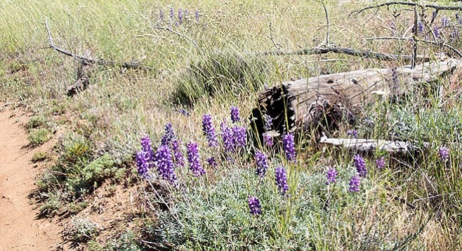
Grape-soda lupine along the trail — it smells like grape soda!
Prior the 2003 Cedar Fire, the Cuyamaca Mountains in general, and this area in particular, had a beautiful forest of mature shady oaks and tall pines, with occasional openings of grassy meadows. The area is not what it was before the fire, but there is still much to see and experience in this large wilderness area. A visit provides an opportunity to see the forests’ remarkable level of recovery from the fire, though it is still a work in progress. Also, there are views of distant ridges and grasslands from this rolling plateau, perched on the flanks of Cuyamaca and Japacha peaks. In the spring you will find a spectacular array of wildflowers, including grape-soda lupine (yes, it does smell like grape soda), wine cup clarkia, splendid mariposa, yarrow, and scarlet larkspur.
Cross the highway from the parking area and find a locked gate crossing a dirt road leading up the hill from SR-79. This is the West Mesa Fire Road (Google Maps shows it as the Japacha Fire Road). There is a sign on the right for the West Side Trail, but it is not part of this hike. Go around the gate and continue up the fire road for 0.6 mile to its junction with the Fern Flat Fire Road. At this point you have completed the stem of the loop. Go either left or right to complete the loop, but this description recommends a right turn up the Fern Flat Fire Road where you will return to this point on the last leg of the hike.
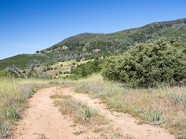
View of Japacha Peak from the West Mesa Trail
Although evidence of the fire remains in the ghostly dead trees, they stand above the bright green of montane chaparral shrubs and grasses that now cover the hillsides. Periodically the trail passes through dense stands of tall whitethorn ceanothus or California lilac that appeared and have grown vigorously after and in response to the fire. Almost all of the pines were killed by the 2003 fire and are now either blackened or silver spears rising into the sky or fallen logs. Many interior live oaks were killed, but those that survived, though badly scarred, are now recovering. Seedling black oaks have appeared while fire casualties, with dead branches, have new growth sprouting from roots that survived the fire. Assisting this natural reforestation, the park managers have planted numerous pine seedlings, some of which are now several feet high.
Go northwest on the Fern Flat Fire Road for 0.8 mile, then find the single-track West Mesa Trail, branching off to the left, and take it. At this point you enter the designated wilderness area where mountain bikes are not permitted. The West Mesa Trail goes through grassy meadows, dense patches of chaparral, and recovering black and live oak forest. At 1.4 miles, pass the Burnt Pine Trail to Cuyamaca Peak on the right and continue straight ahead on the West Mesa Trail for another 1.5 miles. Pass the Arroyo Seco Trail junction and continue east along Airplane Ridge to the Monument Trail coming up from Green Valley. The West Mesa Trail takes a sharp left turn at this point, descending down to Japacha Creek.
You might consider a short but steep detour to the Airplane Monument off to the right that is a memorial for two aviators who were killed when their plane crashed here in 1922.
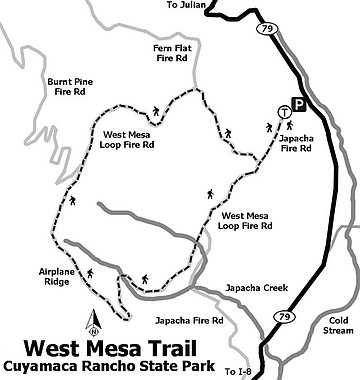
West Mesa Trail Map, Cuyamaca Rancho State Park
Come back to the West Mesa Trail and descend another 0.2 mile into the dense riparian growth along Japacha Creek, with thickets of native azaleas, wild rose, and ferns under tall willows and sycamores. The trail goes northeast after it leaves the creek, following the contours of the canyon, but is 40 to 80 feet above it. In about half a mile, the trail will pass Japacha Spring on the right. This is another opportunity for a short detour, though the spring is now only a wet spot. Just ahead is the junction of the West Mesa Trail with the Japacha Fire Road, also on the right. Your path is straight ahead in a northeasterly direction on the trail now signed “West Mesa Fire Road.” In another mile will be the junction of the West Mesa Fire Road with the Fern Flat Fire Road, on your left. Continue down the West Mesa Fire Road to reach SR-79 and your parked vehicle.
WEST MESA LOOP HIKE — Cuyamaca Rancho State Park
Distance from downtown San Diego: 49 miles. Allow 55 minutes driving time (Cuyamaca Mountains). Directions: Take I-8 east and exit at SR-79/Japatul Valley Rd. Drive north about 10 miles on SR-79 to the signed “West Mesa Parking” on the right that serves other trails in addition to this one. If driving south from Julian it is 13.8 miles to the trailhead.
Hiking length: 6.9 miles.
Difficulty: Moderate. Elevation gain/loss of about 1000 feet. No facilities or drinking water. The fire roads that are part of this loop are open to mountain bikers, but much of this hike is on trails restricted to hikers and equestrians. Dogs are not permitted on any trails or unpaved fire roads. Best time for this hike is from October through June.
Here's something you might be interested in.
Mother offers grape-soda lupine and wine cup clarkia
Spectacular views of distant ridges and grasslands from this rolling plateau
Mother offers grape-soda lupine and wine cup clarkia
Spectacular views of distant ridges and grasslands from this rolling plateau
Grape-soda lupine along the trail — it smells like grape soda!
Prior the 2003 Cedar Fire, the Cuyamaca Mountains in general, and this area in particular, had a beautiful forest of mature shady oaks and tall pines, with occasional openings of grassy meadows. The area is not what it was before the fire, but there is still much to see and experience in this large wilderness area. A visit provides an opportunity to see the forests’ remarkable level of recovery from the fire, though it is still a work in progress. Also, there are views of distant ridges and grasslands from this rolling plateau, perched on the flanks of Cuyamaca and Japacha peaks. In the spring you will find a spectacular array of wildflowers, including grape-soda lupine (yes, it does smell like grape soda), wine cup clarkia, splendid mariposa, yarrow, and scarlet larkspur.
Cross the highway from the parking area and find a locked gate crossing a dirt road leading up the hill from SR-79. This is the West Mesa Fire Road (Google Maps shows it as the Japacha Fire Road). There is a sign on the right for the West Side Trail, but it is not part of this hike. Go around the gate and continue up the fire road for 0.6 mile to its junction with the Fern Flat Fire Road. At this point you have completed the stem of the loop. Go either left or right to complete the loop, but this description recommends a right turn up the Fern Flat Fire Road where you will return to this point on the last leg of the hike.
View of Japacha Peak from the West Mesa Trail
Although evidence of the fire remains in the ghostly dead trees, they stand above the bright green of montane chaparral shrubs and grasses that now cover the hillsides. Periodically the trail passes through dense stands of tall whitethorn ceanothus or California lilac that appeared and have grown vigorously after and in response to the fire. Almost all of the pines were killed by the 2003 fire and are now either blackened or silver spears rising into the sky or fallen logs. Many interior live oaks were killed, but those that survived, though badly scarred, are now recovering. Seedling black oaks have appeared while fire casualties, with dead branches, have new growth sprouting from roots that survived the fire. Assisting this natural reforestation, the park managers have planted numerous pine seedlings, some of which are now several feet high.
Go northwest on the Fern Flat Fire Road for 0.8 mile, then find the single-track West Mesa Trail, branching off to the left, and take it. At this point you enter the designated wilderness area where mountain bikes are not permitted. The West Mesa Trail goes through grassy meadows, dense patches of chaparral, and recovering black and live oak forest. At 1.4 miles, pass the Burnt Pine Trail to Cuyamaca Peak on the right and continue straight ahead on the West Mesa Trail for another 1.5 miles. Pass the Arroyo Seco Trail junction and continue east along Airplane Ridge to the Monument Trail coming up from Green Valley. The West Mesa Trail takes a sharp left turn at this point, descending down to Japacha Creek.
You might consider a short but steep detour to the Airplane Monument off to the right that is a memorial for two aviators who were killed when their plane crashed here in 1922.
West Mesa Trail Map, Cuyamaca Rancho State Park
Come back to the West Mesa Trail and descend another 0.2 mile into the dense riparian growth along Japacha Creek, with thickets of native azaleas, wild rose, and ferns under tall willows and sycamores. The trail goes northeast after it leaves the creek, following the contours of the canyon, but is 40 to 80 feet above it. In about half a mile, the trail will pass Japacha Spring on the right. This is another opportunity for a short detour, though the spring is now only a wet spot. Just ahead is the junction of the West Mesa Trail with the Japacha Fire Road, also on the right. Your path is straight ahead in a northeasterly direction on the trail now signed “West Mesa Fire Road.” In another mile will be the junction of the West Mesa Fire Road with the Fern Flat Fire Road, on your left. Continue down the West Mesa Fire Road to reach SR-79 and your parked vehicle.
WEST MESA LOOP HIKE — Cuyamaca Rancho State Park
Distance from downtown San Diego: 49 miles. Allow 55 minutes driving time (Cuyamaca Mountains). Directions: Take I-8 east and exit at SR-79/Japatul Valley Rd. Drive north about 10 miles on SR-79 to the signed “West Mesa Parking” on the right that serves other trails in addition to this one. If driving south from Julian it is 13.8 miles to the trailhead.
Hiking length: 6.9 miles.
Difficulty: Moderate. Elevation gain/loss of about 1000 feet. No facilities or drinking water. The fire roads that are part of this loop are open to mountain bikers, but much of this hike is on trails restricted to hikers and equestrians. Dogs are not permitted on any trails or unpaved fire roads. Best time for this hike is from October through June.
Comments